Pangbourne Circular walk
Pretty villages, a toll bridge, fine views of the Thames in the morning and a serene stroll through a rural idyll after lunch.


Book 1, Walk 4, Pangbourne Round 1
27 January '07
book1 round pangbourne walk4 swcwalks tocw14 378746574
Book 1, Walk 4, Pangbourne Round 2
27 January '07
book1 round pangbourne walk4 swcwalks tocw14 378749013

Book 1, Walk 4, Pangbourne Round 3
27 January '07
book1 round pangbourne walk4 swcwalks tocw14 378751005

River Thames & Crays Pond
| Length |
13.7 km (8.51 miles), 4 hours. For the whole outing, including trains, sights and meals, allow at least 7 hours 30 minutes. |
|---|---|
| Toughness |
3 out of 10 |
| OS Maps |
Explorer 171 or Landranger 175. Pangbourne, map reference SU 633 766, is in Berkshire, 8 km west along the River Thames from Reading. |
| Features |
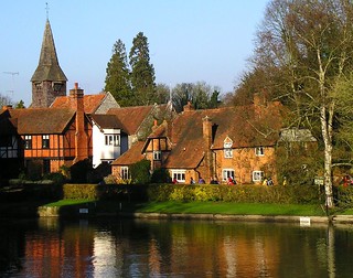
Pangbourne and its companion Whitchurch, on the other side of the River Thames – in Oxfordshire – are delightful villages, spoilt only by too much traffic. Passing on a toll bridge over the river, you come to St Mary’s Church, with the route continuing along part of the Thames Path National Trail (which opened in 1996) past Coombe Park, to a wood with views down to the Thames. From there it is up through a nature reserve and Great Chalk Wood, from where the original route diverts to Hill Bottom and a pub for refreshments and or lunch. You then walk through a pocket park and then re-connect with the original walk's route to go through woods and fields, then head back down through Whitchurch and into Pangbourne for a late lunch or tea. |
| Walk Options |
At point [6] in the walk you could head south to Cold Harbour and reduce the length of this walk by about 3 km. Or you could call for a taxi from your lunchtime pub. Should you wish to extend the walk once back in Pangbourne, you have the option of taking the tow path beside the River Thames, either in an easterly direction to Tilehurst via Mapledurham, or in a westerly direction To Goring. Both are approx. 3.5 miles (5.6 km) and both make for a relaxing end to your walk. |
| History |
The earliest mention of Pangbourne is in a Saxon charter of the year 844 as Paegingaburnam (meaning “streams of sons of Paega”). In 1919, DH Lawrence stayed in Pangbourne, commenting: “Pleasant house – Hate Pangbourne – Nothing happens”. Kenneth Grahame, author of “The Wind in the Willows”, lived in Church Cottage, Pangbourne. An Act of Parliament in 1792 allowed the building of Whitchurch Toll Bridge, to replace the ferry. The ten proprietors were given the right to charge tolls – for instance, one halfpenny for every sheep and lamb. The present iron bridge of 1902 replaces two previous wooden toll bridges. Today, pedestrians cross the bridge toll-free: the 2021 toll charge for cars is 60 pence. St Mary’s Church in Whitchurch dates from the twelfth century. St Birynius is said to have landed at the ferry crossing at Whitchurch and, on seeing how fine the place was, decided to build a church there. |
| Travel |
Take the train nearest to 10 am from London Paddington Station to Pangbourne, journey time just over one hour on the direct, stopping service to Oxford or Didcot Parkway. You can save about 15 minutes by taking a fast train to Reading and changing there for the stopping service. Return trains are hourly (November 2022) weekdays and at weekends, direct or changing at Reading for a faster service. Senior walkers with London Council Freedom Passes can travel on the Elizabeth Line (TFL Rail trains) from Paddington to Reading and back free of charge. You only have to buy a day return from Reading to Pangbourne. However, if you travel on Great Western trains, you will need to buy a day return to Pangbourne. |
| Lunch |
The TO book's suggested lunchtime stop, the White Lion in Crays Pond, closed in 2013. Present day owners are in dispute with the local authority over community interest in retaining the property as a pub, for future reopening as such. As of Winter 2024, the property remains empty and is deteriorating. The suggested alternative lunch stop during the walk is the pub in Hill Bottom, the Sun Inn (tel 0118 984 3909), some 9 km into the walk. The pub claims to be a traditional country pub, and recent reports are better since its last change of management in 2022. As of 2024, the pub is open for drinks seven days a week although food (lunch) is only served on five days: kitchen closed Monday and Tuesday. Lunch is served Wednesday to Friday from 12 noon until 2-30 pm, on Saturday from 12 noon until 8-30 pm and on Sunday from 12 noon until 4 pm. If you opt to by-pass The Sun Inn and head back to Whitchurch (effectively doing the walk without a mid-refreshment stop - which is quite feasible) you can take a late lunch in Whitchurch at the Greyhound pub (tel 0118 9842160) on Saturdays and Sundays, when food is served until 4.00 pm (but the pub closes at 3.00 pm during the week - and is closed on Tuesdays). It serves good basic pub grub. Another good alternative for a late lunch is the Swan pub on the River (tel 0118 9844494), a hundred metres from Pangbourne Station, open all day, with an extensive menu and good food (albeit a bit expensive) but arguably worth the extra for the pub's comfortable seating and nice setting. |
| Tea |
The suggested tea place for this walk (for those who stopped for a picnic en route ) used to be Lou La Belle Café but this was sold in 2020. Alternatives are now the George Hotel (tel 0118 9842237), The Elephant Hotel (formerly the Copper Inn - tel 0118 9842244), which serves cream teas from 3.00 pm to 6.00 pm daily, or the Cross Keys pub (tel 0118 9843268). Opposite the George Inn is a Co-op Convenience store. The Ferryboat Inn , by the railway station, is another option for you. |
| Updates |
Online version recommended. Latest minor corrections, updates and changes to Directions - last book check December 2021. Walk distance aligned to GPS February 2024. Lunch pub update February 2024. |
| Book |
This walk was originally published in Time Out Country Walks near London volume 1. We now recommend using this online version as the book is dated. The book contained 53 walks, 1 for every week of the year and 1 to spare. Here is our suggested schedule |
|---|---|
| Profile | |
| Help Us! |
After the walk, please leave a comment, it really helps. Thanks! You can also upload photos to the SWC Group on Flickr (upload your photos) and videos to Youtube. This walk's tags are: |
| By Train |
Out (not a train station) Back (not a train station) |
| By Car |
Start RG8 7DY Map Directions |
| Amazon | |
| Help |
National Rail: 03457 48 49 50 • Traveline (bus times): 0871 200 22 33 (12p/min) • TFL (London) : 0343 222 1234 |
| Version |
Feb-24 Marcus |
| Copyright | © Saturday Walkers Club. All Rights Reserved. No commercial use. No copying. No derivatives. Free with attribution for one time non-commercial use only. www.walkingclub.org.uk/site/license.shtml |


Walk Directions

- [1] From Platform 1 at Pangbourne Railway Station go down into the tunnel, turn left and go up steps on the other side to Platform 2, exit the station and turn right downhill along the station approach road, your direction 100°.
- In 100 metres at a T-junction with the A329 road, cross over the road and continue straight on along a car-wide road, The Wharf, signposted as a public footpath, your direction 60°.
- In 90 metres you cross the Pang, a tributary river and with Waterside House ahead of you, turn left on a path between railings, with the River Thames on your left-hand side. In 100 metres cross a gravel road to continue straight on, between walls. In a further 25 metres, at a T-junction with the B471 road, turn left, your direction 55°, to pass the Boathouse Surgery on your left-hand side.
- In 110 metres you begin to cross the Whitchurch Toll Bridge on the River Thames. 5 metres beyond the toll both on the far side of the bridge [2] turn left on the signposted Thames Path, up a drive beside a gate post marked “The Mill. Private Drive. Church Cottages”, your direction due west, with the river on your left-hand side.
- In 65 metres, just past Church Cottages on your right, turn right onto a tarmac path marked ‘Thames Path and Footpath to the Church’, your direction 5°, to enter St Mary’s Church, Whitchurch.
- Coming out of the church, go straight ahead through its lychgate and keep straight on, now on a tarmac road (or if not visiting the church, pass the church and its lychgate on your left-hand side and turn half right onto the tarmac road). Bear right with this road and in 100 metres rejoin the B471 road where you turn left, and follow the Thames Path sign, your direction due north.
- In 45 metres you pass the Greyhound pub on your right-hand side (a late lunch option on your return leg of the walk). Keep ahead along the road, uphill, in 200 metres passing Manor Road on your left and in a further 155 metres passing Hardwick Road on your right. Veer left with the road as it narrows and goes more steeply uphill and in 110 metres [!] with a signpost on the other side of the road, pointing left, turn left onto a bridleway signposted “Thames Path – Goring 3.5 miles” and “Hartslock Bridleway”. You now keep ahead along this bridleway, a surfaced road, for some 1.2 km, initial direction 275°
- In more detail: The road soon goes gently uphill with a fence and hedge on your left and a fence and fields to your right. In 350 metres you pass the entrance to Avoca Farm on your right and in a further 130 metres you pass a turn on your right to Long Acre Farm. Keeping ahead, the road dips and rises again and in 160 metres you pass Rivendell Farm on your right. In a further 200 metres you begin to get a good view of Coombe Park (as marked on the OS map) over to your left.
- Stay on this road for a further 350 metres, passing cottages and farms, then as the road swings left into Hartslock Farm [!] leave the road [3] to follow a blue arrow straight on (to the left of a metal fieldgate), your direction 325°, to go down a set of 22 wide earth steps. At the bottom of the steps keep ahead down an earth car-wide path and in 80 metres you go up a steep slope (the flight of 16 earth steps has gone), to continue ahead, uphill, between wire fences and hedges.
- The wide path narrows and in 250 metres you enter Hartslock Wood by a ’Private Woodland’ sign and a Thames Path blue arrow. Now follow Thames Path blue arrows on posts along this path above the River Thames (below on your left) as the path winds its way through the wood, along the hillside, gradually descending towards the river.
- In 250 metres you begin to have fine views of the river on your left. In a further 700 metres you pass a concrete pillbox on your left-hand side. In a further 250 metres, and 5 metres before the end of the wood, by a blue arrow on a post, and with a large beech tree overhanging the way, [!] turn right uphill, quite steeply, your direction 20°. In 20 metres go through a wooden swing gate to exit the wood into Hartslock Nature Reserve; there is an information board about the nature reserve on your left.
- Turn right and ascend steeply up a small hill, your direction 60°. In 110 metres, at the top of the hill, you pass a bench on your right, from which there are fine views of the River Thames below. Now drop down the other side of the hill on a clear grassy path and at the bottom, in 100 metres, you exit the reserve through a wooden swing gate to the left of a metal fieldgate, passing another "Welcome to Hartslock Nature Reserve" information panel on your left, to turn left onto an earth road, your direction 285 degrees [4].
- The road swings to the right and after 150 metres you come out to a T-junction with a tarmac private road, where you turn right, uphill, your direction 30°.
- In 400 metres, as the road emerges from woods, and after a steady bend to the right, [!] turn left through a wooden kissing gate, to follow the public footpath, your direction 70°.
- In 18 metres go through another wooden kissing gate to pass farm buildings on your right. Now dog-leg left then right around a mound and turn right onto a farm track coming in from your left.
- Keep on the farm track as it bears to the right, to go along the edge of a gravel farm apron to Upper Gatehampton Farm (so marked on the OS map). In 65 metres bear left through a wooden kissing gate to go diagonally across a grassy field, your direction 60°, making for a kissing gate in the distance, at the edge of woods.
- In 230 metres, go through this wooden kissing gate and into Great Chalk Wood (so marked on the OS map) and in 5 metres keep ahead (slightly right) to follow the footpath, your direction 85°. On your left is a small information panel on the Great Chalk Wood. In 35 metres cross a path (marked ‘Permitted Bridleway – Not a Public Right of Way – Persons may use at own risk’) and keep ahead on the public footpath, now a broad way, following yellow arrows.
- [5]In 150 metres cross a car-wide track to continue ahead, now downhill. In a further 125 metres, keep ahead at a path crossing, your direction 115° as the path begins to descend a little more steeply.
- In 45 metres, at a path T-junction turn left (by hinges for a missing swing gate), following a blue bridleway arrow, your direction 5°, downhill on a path with an uneven footbed, initially in a shallow cutting. In 105 metres, at the bottom of the slope, at the edge of the wood, cross a path and veer right, now gently uphill, your initial direction 100°, on a path just inside the left-hand edge of the wood.
- In 400 metres go through a wooden swing gate marked Bottom House Farm (sign missing December 2021). In a further 100 metres, just after you pass a small wooden horse stable in the paddock on your right-hand side, go through another wooden swing gate. In 80 metres you pass the farmhouse on your left-hand side and keep ahead, now on the farm driveway. In 100 metres you pass through the main entrance gate to the farm.
- Continue along the farm access road through woodland, gently uphill, your direction 75°. In 350 metres, as you emerge from the woodland, before reaching a large house on the left, and 5 metres before a bridleway to the right [6].
- Here you have a choice: take a shortcut avoiding the pub in Hill Bottom, or the main route via the pub.
- To take the shortcut to Cold Harbour: Take the bridleway on the right (5 metres after point [6]). Follow this path as it winds uphill, keeping close to the left-hand edge of the wood, your direction west of south. In 120 metres the path comes out on to a tarmac access road, opposite a farmhouse. Turn left on this road. In 70 metres the road swings to the right, your direction now due south. Now continue along the road, passing a number of large detached residences on your right-hand side. In 250 metres the road comes to a T-junction with a lane, with Laurel Cottage on your right-hand side, where you turn right point [7B].
- To continue on the main route: Keep ahead on the farm access road, still gently uphill. In 150 metres the access road joins a tarmac drive, with a sign on the left to “Eggar Stuart Cottage and Silver Birch”. Keep ahead, now steadily uphill, passing cottages on your left and right, and in 200 metres the drive comes out to the B471 road at Blackbird’s Bottom.
- Cross over the road and turn left and in 20 metres turn right through a wooden kissing gate, to follow the direction of the footpath sign, half left (50°) across an open, grassy field, within the grounds of the Oratory Preparatory School. In 200 metres you pass to the left of a line of 7 conifer trees, to continue ahead, in the same direction, now along the edge of sports pitches. In 100 metres, at the far end of the field, turn right along the field edge, passing the sports pitches over to your right. In 90 metres, in the top left-hand corner of the field, you exit the playing fields through a wooden barrier to come out on to the B4526 road (next to the school’s exit road). [6A] Turn right along a path just above and to the right of the road.
- In 80 metres, drop down from the path, and cross the road. 10 metres to the right of a metal barrier on your left (giving access to a farm produce shop), turn left on to a footpath into woodland. In 5 metres, at a path T-junction, turn right , your direction 80°. Now follow white arrows on trees as the path winds downhill through woods. This path tends to be muddy in winter.
- In 400 metres you pass to the left of fencing around a builder's depot. [7] At its end, you reach a path and car-wide track crossing where you turn right on to the car-wide earth track (named as Eastfield Lane on the OS map), uphill, your direction due south. In 200 metres the track comes out through anti fly-tipping barriers on to the B4526 road, which you cross.
- [7A] Here you have a choice: 1) the route to the Sun Inn for a drink and or lunch or 2) continue on the original Book route back to Whitchurch and Pangbourne)
1) Refreshments and lunch at the Sun Inn Option
- On the far side of the B4526 road, take the left-hand path of the two (almost directly ahead) signposted Whitchurch Hill, 1 mile, your direction due south. Follow white arrows on trees through a lightly wooded area and in 90 metres drop down to walk around the fenced boundary of March’s builder’s yard, following marker posts with yellow arrows on discs.
- You next enter a wood. In 20 metres pass by another arrow on a post to cross a main track and keep ahead, now on a broad earth path, your direction 195°. Follow white markings on trees and in 200 metres you pass by what used to be a vehicle trailer barrier, but now some large tree trunks in its place, to keep ahead. Ignore ways off and in 90 metres, with another tree trunk barrier ahead, you come to a T-junction with a bridleway, beside a post with blue arrows. Turn right to join the bridleway, your initial direction 210°, gently downhill, soon between hedges.
- In 160 metres, at the bottom of the bridleway, it joins a concrete farm track (Gashes Lane). Keep ahead on this track, now gently uphill. The track levels out and its surface becomes unmade gravel. Pass by properties on your left-hand side and after 110 metres you come out to a tarmac car road, at a bridleway crossing. Turn left down this road, your direction 100°. Ignore ways off and in 180 metres you come to the Sun Inn on your left-hand side.
- Coming out of the pub turn right out of the pub and retrace your steps to the bridleway crossing, 180 metres gently uphill. At the bridleway crossing, turn left onto Bridle Road, your direction 200°, on a gravel drive between wooden fences.
- In 50 metres pass by a concrete bollard in the middle of the drive (now an earth path) and in a further 110 metres pass by another similar bollard. Your path now is parallel to an access road to a modern estate of detached houses on your left-hand side. Keep ahead along the path, which in 60 metres becomes an unmade access road to properties. Keep ahead, gently downhill, and in 140 metres the access road swings to the left, still downhill, your direction now 170°. In a further 130 metres the access road comes out to a tarmac road, opposite a wooden bus shelter, in turn next to a well with pulley mechanism, protective iron railings and roof structure, erected by one Samuel Weare Gardinder Esq in 1853.
- Turn right along this tarmac road, your direction 240°. You pass Butler’s Farm on your left and some 150 metres along this road you come to a pocket park (Whitchurch Hill Recreation Ground) on your right-hand side.
- In 60 metres, at a sign for the Chilterns Way Extension, turn right and cross the park, heading towards its far side, to exit the park in 90 metres through a gap to the right of a wooden fieldgate, onto a road (the B471 once again), where you turn right, your direction due north.
- In 40 metres you pass a lychgate into the small Church of St John the Baptist, Whitchurch Hill (well worth a look inside, when not locked). Continue along the road past the church, and in 20 metres you pass Goring Heath Parish Hall on your left-hand side.
- At the end of the hall, turn left by a signpost for the Chiltern Way Extension, on to a concrete road to “Beech Farm – No Through Road” your direction 260°, with a tall hedge on your right (in which is a line of telegraph poles) and with a metal slat fence on your left.
- In 180 metres, just past Laundy Cottage on your right, as the road swings to the left [!] go through a metal kissing gate on your right (almost directly ahead of you) to enter a field.
- Continue ahead on an indistinct path beside a hedge on your right. In about 90 metres at the field corner, with a metal kissing gate on your right, [!] turn sharp left along the field edge, with a fence on your right-hand side. In 95 metres go through a wooden swing gate and cross over the concrete driveway to Beech Farm - you are now back on the original Book route, at point [9] below.
2) Continue on the original Book route
- On the other side of the B4526 road [!] take the right-hand footpath of two, signposted to Cold Harbour, your direction 220°. In 30 metres you reach an open space with a concrete base. Keep ahead over it and in 80 metres you have a rusty iron fence on your right as you head up through the wood in a south-westerly direction.
- Ignore ways off and in 300 metres go through a metal kissing gate to leave the wood and keep ahead along the right-hand edge of a field (Coombe End Farm) to follow a fence on your right-hand side.
- In 400 metres go through a field boundary, and keep ahead, now on a car-wide earth road, your direction 260 degrees. In 150 metres, pass a timber framed house on your right-hand side and go through a metal swing gate to the left of a metal fieldgate, to come out on to the B471 (with the entrance to Oratory Preparatory School some 20 metres over to your right).
- Cross over the road and continue along the tarmac road opposite, your direction still 260°. In 125 metres you pass under mini pylons. In a further 225 metres you pass a bridleway on your right-hand side beside Laurel Cottage.
Both Routes Continue
- [7B] (The Short Cut Route rejoins here). Turn left and in 85 metres, as the road bends to the right and opposite Coldharbour Farm, go through a metal kissing gate on your left-hand side and take the footpath in the direction of Whitchurch, your bearing 165°, across an open field.
- Pass to the left of a clump of trees and in 300 metres, at a field boundary, go through a metal kissing gate into the next field. In 200 metres you cross a stile to emerge on to a tarmac road opposite a house called Pine Paddock [8].
- Turn right on the road, your direction 250°. In 75 metres, by a footpath sign to Whitchuch, turn left through a wooden swing gate to the left of a wooden fieldgate to Boundary Farm, down a earth car road, your direction 165°.
- In 115 metres you pass the farm and in 20 metres, as the earth road swings to the right towards a hay barn some 25 metres away [!] turn left into the wood, following a yellow arrow on a post, your initial direction 145°.
- Follow the path as it winds through the wood. In 100 metres the path becomes enclosed by chestnut paling fences on either side. Continue along the enclosed path as it meanders on through the wood, following yellow arrows.
- In 300 metres go through a metal kissing gate and come out to a T-junction with a path, where you turn left following a Chiltern Way sign, your direction 150°, keeping close to the left-hand edge of the wood.
- In 135 metres leave the wood by a metal kissing gate [8A][!]. Swing right and keep ahead along the right-hand edge of a field with its fence on your right-hand side, your direction 170°.
- In 95 metres go through a wooden swing gate and over the concrete driveway of Beech Farm (so marked on the OS map) [9]. [[!] There used to be a boisterous dog here which bit more than one SWC walker in the past, but the dog seems to have gone]. Pass between a gap in the trees and follow the footpath sign around to the right along the edge of a lawn, with a fence and hedge on your right-hand side, your direction 195°.
- In 40 metres pass through a metal kissing gate (a tight squeeze) with an metal fieldgate on its left-hand side to continue on a wide grassy path between fences, your direction now 200°. The path goes in and out of light woodland.
- In 260 metres go through another metal kissing gate, to the right of a metal fieldgate, to follow the field edge on your right, with open fields to your left. Keep ahead, roughly parallel to a power line some 65 metres over to your left, along a path that in winter can be muddy in places.
- In 500 metres, as the power line converges with your way, you pass a pylon on your left (where the electricity cable goes underground) and go through a metal kissing gate. Drop down a woodland path, keeping ahead (slightly right) and in 75 metres you come down on to the B471 road [10].
- Continue on the B471 into Pangbourne, your direction 190 degrees. In 40 metres you pass Whitchurch War Memorial on your right-hand side. A short distance beyond this you can pick up the path parallel to the B471 and above it, on the left-hand side. 350 metres along this path, you drop down to rejoin the road (opposite the Thames Path which you took on your outward journey).
- Opposite the turning on the left to Hardwick Road you pass the interesting Modern Artists Gallery (tel 0118 9845893) on your right-hand side: they are open to walkers dropping in and are tolerant of muddy boots.
- Retrace your morning route, passing the Greyhound Inn (a late lunch option at weekends) on your left-hand side. Cross back over Whitchurch Toll Bridge and pass Pangbourne Working Men’s Club on your right-hand side. Go under the railway bridge and in 50 metres, at the mini-roundabout junction with the A329, Reading Road, you pass the George Hotel on your right-hand side - another possible tea/ late meal stop.
- Turn right at this roundabout and in 85 metres you come to another mini-roundabout, with the The Elephant Hotel - another possible tea/ late meal stop - opposite.
- If you now turn left, you come to the Cross Keys pub on your left-hand side in 60 metres. But to get to the railway station, turn right at the road junction opposite the Elephant, to pass the Parish Council Offices and Village Hall on your left-hand side (with a useful WC block in the front of the car park).
- In a further 100 metres, just before the railway bridge, turn left up the lane to Pangbourne Railway Station. Pass under the tunnel to reach platform 2 for trains to London. (Alternatively, you can walk under the railway bridge and take the access road on your left-hand side, which leads to the station. Platform 2 is now on your nearside).