Bures to Sudbury walk
The Stour Valley Way, Gainsborough country and historic Sudbury.
Shades of Green
with cow parsley fringe Bures to Sudbury
suffolk book1 essex walk8 walkicon swcwalks 17422566453

Gainsborough country
| Length |
16.62km (10.33 miles), 4 hours 30 minutes. For the whole outing, including trains, sights and meals, allow at least 9 hours 30 minutes. |
|---|---|
| Toughness |
3 out of 10 (4 plus when overgrown in summer or muddy in winter) |
| OS Maps |
Explorer 196 or Landranger 155. Bures, map reference TL 903 338, is in Essex, 13km north-west of Colchester and 8km south of Sudbury, which is in Suffolk. |
| Features |
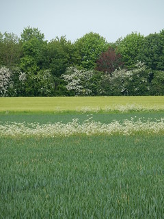
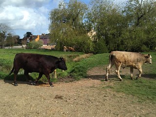
This walk has few hills and some pleasant scenery. Sudbury lies at the heart of the Stour Valley, designated an Area of Outstanding Natural Beauty. Much of the walk is along the Stour Valley footpath, which is well waymarked. In summer some paths can be overgrown - much depends on when the Council's Countryside Department last arranged for the paths to be cleared. If your walk happens to be just before a scheduled clearance, best you have a walking pole at the ready to beat back the undergrowth. On the final approach into the historic town of Sudbury, you cross the Sudbury Common Lands, a traditional pastoral landscape which has the longest recorded history of continuous grazing in East Anglia, where the painter Thomas Gainsborough is said to have played as a child, to tea in a converted millhouse on the banks of the river. |
| Walk Options |
If you are not having lunch at the suggested pub on the walk's original route, you can avoid the detour to Bulmer Tye by carrying on northwards up the road at point [5] to rejoin the route in 200 metres, at the asterisk [*] below. You can shorten the walk by taking the delightful Stour Valley – St Edmund Way path from the church at Great Henny [4] to rejoin the route at point [6]. This reduces the walk to 12.6 km (7.8 miles). If you would like a long walk you can add the Short Walk version of this walk to Walk 46, Wakes Colne to Bures , making an excellent long ramble of some 20 miles. |
| History |
Bures (pronounced Bewers) is a village which straddles the Essex and Suffolk border, on opposite sides of the River Stour (the county boundary).The Parish of Bures Hamlet is on the Essex side, and Bures St Mary on the Suffolk side. The village is unusual in that it is served by two County Councils and three District Councils - with two Members of Parliament. St Mary’s Church in Great Henny has a tower with parts dating back to the late eleventh century, although most of the church was rebuilt in the middle of the fourteenth century. Holy Innocents Church Lamarsh is one of just a few Grade 1 listed churches in England, and one of only five churches in England dedicated to the infants murdered by King Herod. The original church dates from the early twelfth century and is only one of three Norman churches in England with a round tower. Sudbury Suffolk is a Market Town which dates from Saxon times. In the late middle ages the town thrived as a centre for textiles (wool and silk). One silk mill remains and markets are still held twice a week in the town square. Sudbury's most famous son is Thomas Gainsborough, the eighteenth century portrait painter, who was born in the town in 1727, the youngest son of a wool manufacturer. He studied in London under Gravelot and Francis Hayman. On his marriage in 1746, he moved to Ipswich, where he remained until his move to Bath in 1760. Gainsborough’s House (tel 01787-372958) in Sudbury is now a museum with the most extensive collection of his paintings, drawings and prints in the world (the house is open 10 am until 5.00 pm seven days a week (last entry 4 pm). Newly refurbished and extended, the museum reopened in 2022 and admission prices for 2024 are as follows: House, galleries, cafe and exhibitions - £ 16.50 with gift aid, £ 15 without - concessions available, under 18s free. The Parish Church of St Gregory Sudbury is named after Gregory the Great. Pope from 590-604 AD. A church has been on this site for a thousand years and most parts of the current church date from the fourteenth century. The church is full of historic interest, with an unusually long chancel and an ornate font, and carved misericords in the chancel stalls. One ghoulish, famous relic in the church is the skull of His Grace Simon of Sudbury , a son of Sudbury and one time Bishop of London, Archbishop of Canterbury and Chancellor of England. Chancellor Simon was blamed for introducing a poll tax in England, which resulted in Watt Tyler's peasants revolt in 1381. Cruely beheaded by the peasants, his body was burried in Canterbury Cathedral, with a cannon ball in place of his head, with his head being returned to Sudbury. |
| Travel |
Take the train nearest to 9.45am from Liverpool Street Station to Bures, changing at Marks Tey. Journey time about 1 hour 10 minutes. The change over at Marks Tey is often short (under 5 minutes) but Greater Anglia's current policy (2024) is to hold the Sudbury service for up to 10 minutes if the London train is running late. If you miss the connection, best take a taxi to Bures railway station. Trains back from Sudbury to Liverpool Street are hourly, again changing at Marks Tey. Journey time 1 hour 15 minutes. Buy a day return to Sudbury Suffolk . If planning to take an early lunch at the Lamarsh Lion Community pub, you can take the train one hour later from Liverpool Street, after which it is best you take the short cut to Sudbury, avoiding Bulmer Tye. |
| Lunch |
The suggested lunch place on the original route of this walk is The Fox in Bulmer Tye (tel 01787 275727) some 10 km into the walk. This pub reopened under new management in autumn 2020 and initial reports on this refurbished and smartened-up pub are good. Lunch is served Monday to Saturday from 12 noon until 2.30 pm, and all afternoon on Sunday. As an alternative to the Fox you can stop very early in the walk at the Lamarsh Lion, a community owned pub, some 4 km into the walk or later at the Henny Swan, after a detour to Henny Street. Details of both now follow. The Lamarsh Lion (tel 01787 227 007), a 14th century public house in the village of Lamarsh, reopened in June 2018 as a community pub after being closed for many years. The local community assisted by sponsors raised the half million plus to purchase and rebuild the pub - from the ouside the pub now looks very smart, inside and outside. The pub is closed on Monday and Tuesday.(2024) Food (lunch) is served Wednesday to Friday from 12 noon until 2.30 pm, on Saturday from 12 noon until 3.30 pm, and on Sunday from 12 noon until 3 pm. Booking ahead is advised at weekends. If doing the double header walk - Wakes Colne to Bures to Sudbury - this pub makes a good alternative to the watering holes in Bures for an afternoon break before continuing on to Sudbury. The Henny Swan pub, Henny Street (tel 01787-267953), some 11.5 km into the walk, enjoys a lovely riverside setting and serves good quality food all day, from 11.30 am (12 noon on Sunday) until 9.00 pm, with restaurant and bar menues. Booking in advance at weekends is advisable. A good spot for picnickers is the tranquil grounds of St Mary's Church, Great Henny. |
| Tea |
THE suggested tea place - almost de rigueur - is the comfortable Mill Hotel (tel 01787-375544) in Sudbury. Tea is served 2 pm to 5 pm, with a choice of finger sandwiches, warm scones, pastries and toasted teacakes on offer at reasonable prices. The Hotel’s bar is also open in the afternoon for alcoholic drinks. After tea here allow 20 minutes to get to the railway station. There are a number of pubs in the centre of Sudbury, including the Black Boy Hotel (tel 01787-379046) and the White Horse pub (tel 01787-313508). |
| Updates |
Full check May 2021 with additional minor updates October 2021. Online version recommended.
|
| Book |
This walk was originally published in Time Out Country Walks near London volume 1. We now recommend using this online version as the book is dated. The book contained 53 walks, 1 for every week of the year and 1 to spare. Here is our suggested schedule |
|---|---|
| Profile | |
| Help Us! |
After the walk, please leave a comment, it really helps. Thanks! You can also upload photos to the SWC Group on Flickr (upload your photos) and videos to Youtube. This walk's tags are: |
| By Train |
Out (not a train station) Back (not a train station) |
| By Car |
Start CO8 5HS Map Directions Return to the start: Finish CO10 6SU Map Directions Travel to the start: |
| Amazon | |
| Help |
National Rail: 03457 48 49 50 • Traveline (bus times): 0871 200 22 33 (12p/min) • TFL (London) : 0343 222 1234 |
| Version |
Mar-24 Marcus |
| Copyright | © Saturday Walkers Club. All Rights Reserved. No commercial use. No copying. No derivatives. Free with attribution for one time non-commercial use only. www.walkingclub.org.uk/site/license.shtml |


Walk Directions

- [1] Coming off the platform at Bures Railway Station, go down steps, walk through the station car park and bear left down The Paddocks. In 30 metres, you come to a T-junction where you turn right into Station Hill, due east. In 100 metres, you pass Water Lane on your left-hand side. 40 metres further on, the white coloured building and former Swan Inn is on your right-hand side, just before the T-junction with Colchester Street.
- Beside the former pub turn left off the road and follow the public footpath sign down the wide gravelled lane along the left-hand side of a building, your direction 20°.
- Keep following the high brick wall on your left-hand side, ignoring other ways off. In 180 metres, the path comes to an end of the hedge on your left-hand side, where there is a wooden post with public footpath arrows on it. Turn right and follow the Stour Valley Path along a car-wide track, with a hedge on your right, your direction 350°.
- Follow this track between large agricultural fields for the next 1 km until it brings you down to the River Stour. Where the track swings to the right towards a bridge with metal railings, ignore the bridge and [!] keep ahead, to follow the direction of a footpath post along a narrow path into a clump of trees. 40 metres further on, the path wends its way down to a metal kissing gate, which you go through to enter a grassy field. Ahead of you and over to your right is the River Stour.
- Keep ahead and follow the riverbank, keeping close to the fence on your left, your direction 280°. In 300 metres, you will see a concrete pillbox down by the river below you. 100 metres before you reach the pillbox your way bears half left gently uphill and away from the river, to follow a footpath post.
- In 175 metres at the top of the bank you cross a stile to go over the Marks Tey to Sudbury single track railway line. On the far side of the track cross over another stile and head up a footpath through light woodland. In 70 metres you pass a wooden telegraph pole on your right-hand side, with footpath signs on it. Coming out into the open you take the footpath straight ahead along a car-wide track, heading in the same direction as before. You are now in the village of Lamarsh .
- Along the track you pass a thatched cottage, a barn and a tiled house, all on your right-hand side, and the foundations and slab of a demolished property on your left-hand side, and after 370 metres you come out on to a road. Turn right along the road. In 60 metres you come on your left to the Lamarsh Lion Community pub , your early lunch pub option on this walk. In a further 150 metres follow the road as it curves around to the right, past the turning on the left signposted Horne’s Green. In 110 metres you pass a turning on the left signposted to Alphamstone and Pebmarsh. Continue straight on for Sudbury and Henny.
- 250 metres further on, you pass Lamarsh Village Hall on the right-hand side and a house called Green Hills on your left-hand side. 10 metres beyond, the original walk route took a turning left off the road, following the direction of a concrete public footpath sign up a car-wide grassy track. However, the recommended route now is to keep ahead on the road for a further 110 metres until you come on your right-hand side to Holy Innocent Church Lamarsh, usually open during the day, and well worth a visit inside.
- Coming out of the church take the footpath directly ahead and to the right of The Old Rectory, on a grassy path, uphill, with an open field to your right, and a hedge on your left. In 170 metres, at the top of the slope, turn left to follow the direction of a footpath post. In 30 metres, go through a field boundary and with another footpath post on your left-hand side, turn right to return to the original TO Book's route, along the right-hand edge of a field, initially uphill, and soon with a treeline on your right.
- In 200 metres by a footpath post, keep directly ahead, to go down into a dip and then up the other side into a wooded area, with young trees on either side of the path. Keep ahead, your direction 250° initially. In 200 metres you leave the wooded area at a field boundary as you pass under overhead cables and head down through a wooden kissing gate to come out into a grassy field.
- Follow the left-hand edge of this field, as your way initially swings to the left before it heads in the same direction as before. In 350 metres you come to the far left-hand corner of this field and out through a wooden field gate on to a country lane [2]. Cross over the lane and on its far side you will find a public footpath sign; ignore the stile to the right and follow the direction of the footpath sign, going gently uphill in the same general direction as before, now 310°, on a wide grassy track.
- In 80 metres you pass a wooden fieldgate on your right-hand side and go straight ahead beneath some overhead cables, on a narrow path, with uneven footbed, now with hedges to your left-hand side and a low wire fence to your right-hand side. 180 metres you come to the corner of the field and go into the next field, with a wooden post and wire mesh fence now on your right-hand side.
- In 70 metres, descend to cross over a stile on to a single carriageway, surfaced country lane. Turn right up the hill, your direction 50°. In 300 metres you come to a T-junction with a country road at the top of the hill, with a farm building on the right-hand side. Turn left, your direction 355°. In 150 metres you come to another T-junction, signposted left to Twinstead, and right to Lamarsh. Go straight over the road, following the public footpath sign, through gateposts (the entrance to Valley Farm) and in 10 metres go through a wooden swing gate.
- You then go half-right across the grassy field, your direction 20° [3]. In 30 metres the field dips sharply downhill. Aim for the wooden swing gate which is now visible ahead of you, in the far, bottom right-hand corner of the field. In 130 metres down the hill, you go under some overhead cables. 20 metres further on, go through this swing gate and turn left along a car-wide track, gently downhill, your direction due north.
- In 135 metres, with the metal fieldgate entrance to Valley Farm directly ahead of you, bear right by a footpath post and go through a wooden fieldgate with yellow footpath markings on it [NOT the gate to its right, giving access to Top Farm]. Now head down an earthen farm track, your direction 350°, towards a farm.
- In 100 metres you pass to the right of the farmhouse and keep ahead. In a further 45 metres continue ahead through a gap where previously there was a stile and fieldgate and keep ahead, downhill, following the left-hand edge of a field, with a mesh fence on your right, your direction due north.
- In 105 metres go through a metal swing gate, blocking your way, and keep ahead. In a further 30 metres your way swings left to cross over a wooden plank bridge with a public footpath marker on it, then over a small stream, then another wooden plank bridge to come out into a field.
- Here turn right and follow a (usually) clear path up the field, your direction due north. In 125 metres the path takes you directly under electricity cables on National Grid pylons. 65 metres beyond the pylons you come to the top of the field, to go up earthen steps up the bank to the top.
- At the top do not be tempted to go through the gate directly ahead. Instead, turn left, following the yellow pointer on the post for the Stour Valley Path, your direction 280°. This narrow path follows the direction of the electricity pylons off to your left, with sloping bank dropping away to your left and a fenceline to your right. In 140 metres go through a wooden swing gate and follow the path on the other side in the same direction as before, but now without a fence on your right. In a further 150 metres you come out onto a car-wide track, with the enrance to Georges Cottage on your left-hand side.
- Cross the track, bearing half-left and follow the path directly ahead to the right of a house. Follow the edge of the garden for 25 metres until you come to its far corner, under electricity cables, and by a footpath post turn right in the direction of the footpath post, diagonally across the field, following the line of the National Grid pylons, your direction 265°.
- In 200 metres you pass to the left of the first pylon, to keep ahead over a meadow of rough ground which can be waterlogged after heavy rain and usually is in winter. You are aiming for the lower left-hand corner of the meadow, where it narrows. In 340 metres exit the meadow to come out onto a tarmac road, by a concrete footpath post. Some 20 metres to your right is the entrance to Loshes Woodland Forestry Commission Conservation Area .
- Cross over the road, slightly to your right, and follow the footpath sign up a path ahead which soon comes out into the small visitor car park for Loshes Wood. If you wish you can enter Loshes Woodland through the gate in the deer protection fence some 25 metres to the right of the car park and walk on a permissive path through this conservation area, to exit through another, similar gate some 250 metres away in the far left-hand corner of the woodland, to re-join the route.
- Otherwise, keep ahead up the track, pass under overhead cables and in 50 metres, you come to another Forestry Commission gate. Again, if you wish you can enter the woodland at this point and walk parallel to the public footpath on a permissive path. But the the public footpath is to the left of this gate. Follow this narrow path, with the Forestry Commission fence on your right.
- In 250 metres you come to the far left-hand corner of the field, where you go over a stile to the right of an electric fence and continue straight on along the left-hand side of a large grassy field, with a ditch and a stream on your left-hand side, your direction 280°.
- In 400 metres there is a wooden fence line over to your left-hand side, at the end of a horse paddock. At this point [!] pause and look right across the field, where 85 metres away at the field boundary you can see where your way ahead continues uphill through a wooded area (there is usually a removable insulated break in the electric fence here). Although the official route is to continue down the left-hand edge of the field for another 100 metres or so to then turn right along its bottom and then in 80 metres right again to come up to the break in the fence, try crossing the field on a diagonal by the wooden fence.
- In 85 metres you come to the break in the fence (you can remove the wooden slat to make it easier to climb over the fence - having first released the electric wire hook-up). Pass through and replace the hook-up. Now head up the bank directly ahead of you, initially quite steeply, into woodland, your direction 50°.
- The path begins to level out as you pass conifer trees on your left and deciduous trees to your right. In 100 metres you come to the end of the trees and to a crosspaths. Go straight over and up a hill, ignoring paths to the side, and continue ahead, soon with a wooden fence on your left, your initial direction 15°.
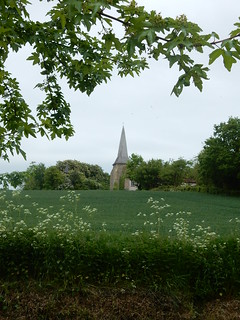
- In 60 metres, where the wooden fence goes away to the left, carry straight on, now downhill along the left-hand edge of a field, with a new wooden fence on your right, heading towards a church spire which you can soon see directly in front of you. 110 metres go through a wooden fieldgate in front of you, cross over a grassy entrance way and in a further 10 metres cross a stile to come out onto a country road.
- Turn right along this road and, in 40 metres, just before you come to Old School House on your left-hand side, turn left uphill along a car-wide earth and gravel track, following the public footpath sign towards the church spire, passing Old School House on your right-hand side. You next pass Great Henny Rectory on your right-hand side as you head up this track.
- 150 metres you come to a wooden gate. On its left there is a smaller wooden gate. [4] This is the entrance to St. Mary’s Church, Great Henny. The churchyard is a good spot for picnickers. You now have a choice of 3 routes to continue the walk , namely the Original TO Book route to Bulmer Tye , and for those on the short walk the St Edmund's Way shortcut route (also recommended for those on the "double header" long walk which started in Wakes Colne), and the Diversion to Henny Street , for lunch at the Henny Swan. Directions for the Diversion to Henny Street are given at the end of these Main Directions.
- The St Edmund's Way shortcut route avoiding Bulmer Tye: pass through the churchyard, with the church over to your right, and exit the churchyard through the lychgate. Cross a concrete drive and take the signposted footpath directly opposite , and follow the St Edmund Way / Stour Valley path (which you have been following from time to time earlier in your walk). The path starts gently downhill, then levels out and starts to go gently uphill through a number of field boundaries. Just keep the church steeple of St Mary's Church directly behind you at all times and follow the path in a northerly direction through delightful, open countryside, and you should not go wrong. In just under a mile the way heads uphill with a line of trees on your right to rejoin the main route at point [6], where, coming from the shortcut, you keep directly ahead at the four-arm footpath sign.
- To continue on the Original TO Book route to Bulmer Tye: Turn left immediately before the entrance gate to the church, your direction 275 degrees. In 15 metres, the hedge on your right-hand side goes sharp right. But you head straight on across the field, on what may be a clear path (depending on the time of year) and aiming for the two houses on the far side. (If the field is in crop or looks very muddy, go back to the churchyard, go through it and turn left on to a road, walk along it in a westerly direction for 300 metres to re-join the route by Henny Parish Room). In 250 metres you come to the perimeter fence around the houses. Follow the direction of the footpath sign around to the left, along the fence, to another footpath sign 40 metres ahead, where you turn right. In 60 metres you come out on to the road.
- Turn right along the road. In 60 metres, you pass The Thatched Cottage on your right-hand side and 15 metres further on ignore a turning to the right signposted ‘Henny Church’. Follow the road as it curves around to the left, past Henny Parish Room on your right-hand side. In 140 metres further on, turn right down two steps, following a public footpath sign, along the right-hand side of the field, your direction due north.
- In 300 metres [!] you come to an oak tree. 20 metres ahead, cross a ditch and by a footpath post turn left, following the right-hand edge of a line of trees, your direction 295°. In 200 metres you pass a farmhouse on your left-hand side (on the other side of the hedge) and 30 metres further on, pass through a gap in the hedgerow straight over into the next field. Walk along the edge of this field in the same direction as before. [!] In 140 metres, turn left over the ditch, then turn right along a car-wide gravel drive, continuing in the original direction, now within the well-maintained grounds of a farming business. 125 metres along this drive, you come out to a T-junction, and turn right into Little Henny. In 160 metres, as the road swings to the right, you pass a house on your left-hand side called Pitfield Green. 200 metres further on, the road curves around to the right, heading towards some trees. Just 5 metres beyond the curve, there is a public footpath sign on the left-hand side of the road. [5]
- If you are not stopping for a picnic lunch in Bulmer Tye, keep on the road northwards for 200 metres to rejoin the route at the asterisk [*]
- Otherwise turn left off the road and [!] follow the direction (300°) of the concrete footpath signpost across the field (which can be very muddy when not in crop) on a path which you may find poorly maintained and or scarcely visible at some times of the year.
- If this field is very muddy and looks too unpleasant to cross, stay on the road for 200 metres, and at the road junction with Ryes Lane, turn left - and reverse the walk directions from The Fox pub, that is: head along Ryes Lane in a north-westerly direction for 1 km until you reach the T-junction with the A131. Turn left along the road, and in 170 metres you come to The Fox pub on your left-hand side, the suggested lunch stop on the main walk .
- In 150 metres, halfway across the field, turn quarter-right, and [!] aim for the short footpath post with a yellow arrow in the first gap in the hedge from the right by a large oak tree, some 40 metres from the right-hand edge of the hedgerow ahead.
- By this footpath post, cross over two wooden planks into the next field. Continue straight on across the field, your direction 315°.
- In 150 metres you come to the far side of the field, where there is another wooden footpath post. Cross on two planks over a ditch to go straight across the next field, in the same direction as before, for 250 metres, [!] aiming for the trees, with a long red-brick building behind them. Once at these trees, turn right, following the left-hand edge of the field, with the trees on your left-hand side.
- 150 metres further on, go through a wooden swing gate, following the direction of the wooden footpath post just before the gate. Keep ahead on a grassy path through a field with young fruit trees and in 70 metres exit the field by another wooden swing gate. Turn left, following the direction of the arrow on the gatepost, into the car park of the Bulmer Fox pub-restaurant .
- After lunch, with your back to the front of the pub entrance, turn right along the road (the A131). In 100 metres you pass Church Road on your left-hand side. 70 metres further on, turn right into Ryes Lane, which takes you back to Little Henny. Walk down Ryes Lane for 1 km, until the road enters some trees and curves sharply around to the right. Directly opposite is the entrance to Henny Lodge (formerly known as The Hall).
- Turn left on a road at this junction [*] following the sign for Ryes House, your direction 55°. In 60 metres you pass Lodge Farm on your left-hand side. 100 metres further on, where a small postbox faces you, take the left-hand fork which is signposted as a public by-way. Walk straight down this car-wide track, your direction 35 degrees, past two brick cottages on your left-hand side.
- In 800 metres the path leads down and out of the trees, and on your right-hand side there is a wooden post with various yellow markers on it. Ignore this and continue straight along the existing path.
- In 600 metres, having gone down the hill and up the other side, at the crest of this hill you have a fine view of Great Henny Church.
- [6] At this crest you come to a four-armed footpath sign (where the path straight on goes through trees). Turn left along the car-wide public footpath, going due north. The short walk from Great Henny Church, and the route from the Henny Swan pub, re-join the main walk here. This car-wide track takes you steadily downhill. In 500 metres you come to the foot of the hill (where there are extensive farm buildings off to the right of the path) and to a footpath sign. Ignore the way to the right and go straight ahead along a car-wide track, due north uphill, along the right-hand edge of a field. In 110 metres where the hedge turns right, keep ahead , a quarter left, uphill on a narrower way and in a further 100 metres at the top of the field pass between a gap in the fence into a field (a new plantation).
- Head straight down this plantation with closely planted young trees on either side of the path: the trees form a close canopy above you when in leaf. You head down to a dip and then up the other side, your initial direction 340°. From here you have a good view of Sudbury away to your right-hand side. In 250 metres, you come to the far side of the plantation and exit it.
- Now follow the path ahead through some trees, your direction 300°, as it winds its way downhill. You are now on the outskirts of Sudbury and can see some houses down on your right-hand side. Ignore ways off and in 200 metres, the path takes you up to the back of a row of houses and you follow the path sharp right down the hill, and down a flight of new wooden steps, parallel with the row of houses.
- In 100 metres you come out on to a residential street, by a public footpath sign. Turn right down the street, your direction 60°. In 100 metres, you come down to the bottom of Pinecroft Rise and turn left . In 100 metres follow the road as it curves around to the right , past Hall Rise (road) on your left-hand side. 70 metres further on, you come to the bottom of Meadow View Road where you reach a T-junction with the main road.
- Cross over the main road and on the far side go through a wooden kissing gate near a sign saying Kone Vale. Go straight ahead down the path through lawns and into the trees. In 250 metres take the right-hand fork in the path, next to a Babergh District Council sign. 15 metres further on, fork left up the slope with metal railings on to the disused railway line.
- At this point, if you wish to go directly to Sudbury railway station without having tea turn right and follow the path along the top of the disused railway line for just over 1 km, passing over a number of bridges, until the path descends, narrows and exits on the flat through a sports centre’s car park, at the end of which you turn right for the railway station.
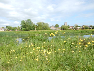
- For the main route: turn left on top of the disused railway line, your direction 310° initially. In 65 metres a bridge takes you over the main road. 125 metres further on, continue straight on over a metal bridge. 250 metres beyond that, you come to a brick bridge with a metal railing, where just before the bridge [!] you turn right and head down steps (with a wooden banister on their right-hand side).
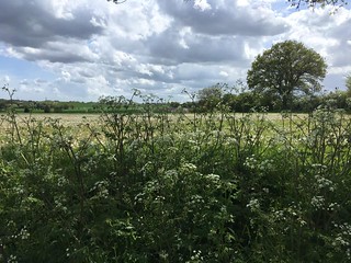
- At the bottom of the steps go around the wooden barrier and head straight across the field ( Sudbury Meadows ) towards the bridge across the river ahead, your direction 80°. In May /early June there is usually a splendid display of buttercups in this field. In 120 metres cross the bridge (with metal gates at both ends) and, on the far side, turn half-left, heading for the Mill Hotel, the large white building to the right of the church tower, your direction 60°. In 300 metres, having crossed two minor streams, you come across the field to a gate leading on to a brick bridge, going alongside a large duck pond and out to the Mill Hotel, Sudbury, on your left-hand side, the suggested tea stop.
- Coming out of the Mill Hotel, if you wish to visit The Parish Church of St Gregory , then turn left outside the hotel's entrace and it is less than 5 minutes walk to the church. Otherwise, coming out of the hotel, go straight up to the top of Walnut Tree Lane. Turn left on the main road, going into town. In 200 metres ignore the road left to Bury St Edmunds and Colchester. Carry on down Gainsborough Street. In 170 metres down on your left-hand side is Gainsborough’s House. A visit is highly recommended. 100 metres further on, you come out into the Market Square. To get to Sudbury railway station, turn sharp right and, in 40 metres, turn left into Station Road. At the bottom of Station Road, the Eastern Station Lounge night club is on your left-hand side and you follow the signs straight across for Sudbury Railway Station.
Directions for Diversion to Henny Street
- To take lunch at the Henny Swan pub: walk through the churchyard of St Mary’s Church, and exit it on the far side. Turn right on a car wide track that leads in 80 metres or so into an open field.
- Keep straight on , gently downhill across the field on a car-wide track. In 300 metres at the far end of the field, curve left with a path towards a rusty, open sided barn, with a treeline on your right-hand side, and then just after you pass the barn curve right , downhill again.
- Beyond the barn, veer left to a tarmac lane/driveway, and turn right , downhill on this lane. Follow the lane for 1.2km until it comes to a T-junction with another road (with a footbridge over the River Stour ahead).
- Turn left on this road and in 250 metres you come on your left to the Henny Swan pub.
- After lunch, come out of the pub and turn left , to carry on along the road. In 100 metres, turn left up a side road, sign posted to ‘Middleton only’. In 375 metres stay on the road as it turns sharp right, ignoring a bridleway to the left, Unless you would prefer to avoid road walking to the village of Middleton by taking a circuitous route over fields to join the St Edmund Way - see box below. If following this field route you are advised to have OS Explorer Map 196 with you.
- Turn left off the road and head along the bridleway, gently downhill, though a light woodland strip. In 125 metres, at a path junction, turn right along a field edge. In 105 metres turn left over the open field and in 160 metres turn right for 80 metres. The path now swings to the left and in 50 metres turn right over a large open field in a west of north-westerly direction. In 340 metres you join the St Edmund Way at a T-junction. Turn right, and continue on this pleasent Way, gently uphill, in a northerly direction. If you now keep the church steeple of St Mary's Church, Great Henny, directly behind you, you should not go wrong. Having passed through a number of field boundaries the path eventually heads more steadily uphill, with a line of trees to your right, to rejoin the Main Walk Directions at point [6].
- Otherwise, for the more direct road route to Middleton, having followed the road sharply around to the right, you soon pass the entrance to Sheepcote Farm on your left-hand side. Climb steadily uphill on this usaully quiet country road for another 1km or so and you come to a T-junction in the heart of Middleton village .
- Turn left here , still signposted to ‘Middleton only’. In another 300 metres the road turns sharp right downhill, with tracks ahead and left. [!] Take the track to the left here, a signposted byway that climbs uphill under trees. In 300 metres, at the top of the hill, you emerge to see open fields left and right. This is point [6] in the Main Directions.
- Turn sharp right onto a car-wide track along the edge of a field, gently downhill with a wood edge to your right. Now resume the Directions in the Main walk from here onwards.