Tring to Wendover walk
A Grand Union Canal walk in the morning, fields in the middle, and finally the wooded hills of the Chilterns


Reservoir nature reserves & Wendover Woods
| Length | 21km (13 miles), 6 hours 30 minutes. For the whole outing, including trains and meals, allow 9 hours 15 minutes. |
|---|---|
| Toughness | 6 out of 10. |
| OS Maps | Explorer 181 or Landranger 165. Tring, map reference SP 952 122, is in Hertfordshire, 13km east of Aylesbury. Wendover is in Buckinghamshire. |
| Features | This walk has plenty of variety - completely flat the first half of the day, starting along the quiet tree-lined banks of the Grand Union Canal, then past 'twitchers with bins' (aka birdwatchers with binoculars) beside nature reserves-cum-reservoirs. In the afternoon the public footpath passes alongside a MOD airfield with gliders pulled by tugs or whipped into the air by a whirling wheel on a stationary lorry. For the last 3km the land changes completely, as you make your way up into a popular part of Wendover Woods, with its "Go Ape" adventure centre, and exercise areas, nearly to the highest point in the Chilterns, and then descend steeply into Wendover. |
| Walk Options |
In the morning you can take the Wendover Arm of the Grand Union Canal in two places: 1) at its junction with the Grand Union just before Marmsworth Top Lock, or 2) - and better - after Tringford Reservoir. The latter avoids the walk around the third reservoir (Wilstone Reservoir) and reduces the walk by 1 km. Brief Directions are provided. After lunch at the Oak, Aston Clinton, you could get a bus in the centre of the village to the centre of Tring (from where you can walk just under two miles or take a bus or taxi to the station). In the afternoon, to avoid the hills up into Wendover Woods, you can take the Wendover Arm of the Grand Union Canal (see the double asterisk [**] in the walk Directions) and follow it all the way into Wendover. This reduces the Main walk by approximately 2 km (1.3 miles). Directions for this short cut are also provided. This walk is now stile-free. |
| History |
The water from the Tring Reservoirs (opened between 1793 and 1805) keeps the Grand Union Canal navigable. The first UK nesting of black-necked grebes was noted here in 1918. The Church of All Saints, Buckland, was built in 1273. At the time, the Lord of the Manor was Hugh le Despenser who, with his son, was executed by his erstwhile friend, Edward II, in 1326. A later Lord of the Manor, the Earl of Warwick ('Warwick the Kingmaker'), was killed by his one-time friend, Edward IV at the Battle of Barnet in 1471. The church is well worth a visit (usually open) to see the lovely building and also the tapestry of the village in several drapes on the west wall, a work of art by villagers. After lunch the route goes through the grounds of the Halton House estate, once owned by the Rothschild family - teams of zebras used to take them to their favourite picnic spot - and now given over extensively to the RAF. Construction of the Wendover Arm Canal started in 1793 to supply water to feed the Grand Union Canal at Tring. It became known as the leaky canal - despite partial relinings in 1803 and 1856, it had to be closed in 1904. Boddington Bank is an Iron Age hill fort overlooking your final destination of Wendover. |
| Travel |
Take the train nearest to 9.20am from Euston Station to Tring. Trains back from Wendover are half-hourly, and return to Marylebone. Journey time about 40 minutes on the way out, 55 minutes for the return. As the two stations are on different lines you cannot get a return ticket for the full walk. Instead, buy an All-Zones Travelcard plus a single from the Zone 6 Boundary to Tring. On the return journey you will also need to buy a single from Wendover to the Zone 6 Boundary. This walk is not recommended for car drivers unless you are prepared to take a taxi back to your car, as there is no convenient public transport link (train or bus) from Wendover back to Tring. |
| Lunch | The Oak pub (tel 01296 630 466) in Aston Clinton is 11.8 km from the start of the Main walk. Excellent and reasonably priced home-cooked food – in very generously sized portions - is served all afternoon from midday (2021) weekdays and weekends. Groups of more than 4 are advised to 'phone ahead to book, as this pub is a popular venue, weekdays and weekends. Booking ahead on a Sunday is essential - and preferably a few days before.
Whilst the diversion is in place as you approach the fields before the Oak pub, where the new Bellway housing development (completed summer 2021) blocks your onward footpath, an alternative pub at weekends comes into play, The Partridge Inn . This pub is a watering hole for beer drinkers but it is only open at weekends in the afternoon (closed week days). The pub does not serve hot food, just bar snacks. |
| Tea | The suggested tea place is Rumsey’s Chocolaterie (tel 01296 625 060), perfect for chocaholics which also serves tea and coffee and is open until 6.30pm Monday to Saturday and 6.00pm on Sunday. Also worth considering are the bar of the 17th century Red Lion Hotel (tel 01296 622 266) and the Shoulder of Mutton pub (tel 01296 623 223), which is close to the train station, and serves food throughout the day . |
| Updates |
Diversion to the lunchtime pub in Aston Clinton (2021) This edition, with minor updates, September 2021. [Older Editions] Use the online version - There has been a Major Change to the route - a detour to cross a new motorway, by going under it, alongside a canal. |
| Book |
This walk was originally published in Time Out Country Walks near London volume 1. We now recommend using this online version as the book is dated. The book contained 53 walks, 1 for every week of the year and 1 to spare. Here is our suggested schedule |
|---|---|
| Profile | |
| Help Us! |
After the walk, please leave a comment, it really helps. Thanks! You can also upload photos to the SWC Group on Flickr (upload your photos) and videos to Youtube. This walk's tags are: |
| By Train |
The out and back routes are with different train companies - check the ticket advice. Out (not a train station) Back (not a train station) |
| By Car |
It is not easy to return to the start by train, as the stations are on different rail lines. Start HP23 5QR Map Directions Return to the start: Finish HP22 6BN Map Directions Travel to the start: |
| Amazon | |
| Help |
National Rail: 03457 48 49 50 • Traveline (bus times): 0871 200 22 33 (12p/min) • TFL (London) : 0343 222 1234 |
| Version |
Jul-22 Marcus |
| Copyright | © Saturday Walkers Club. All Rights Reserved. No commercial use. No copying. No derivatives. Free with attribution for one time non-commercial use only. www.walkingclub.org.uk/site/license.shtml |


Walk Directions

- [1] Bear slightly right through Tring Railway Station forecourt and turn left onto the main road, going past the Royal Hotel Posting House. In 250 meters there is a bridge where the road crosses the Grand Union Canal. [!] Do not cross the bridge. Instead, turn right off the road at the start of the bridge, and take the steps going down on to the towpath. You will walk along the towpath for the next 4km, your direction 290° initially.
- In more detail: in 1.2km you come to a stone bridge across the canal. Follow the path up on to the bridge, across to the other side and down on to the left-hand side of the canal. 900 metres further on there is a second stone bridge (No.133) carrying a road over the canal, with the Grand Junction Arms public house next to the bridge. Continue along the path under the bridge, with a home and garden gallery formed from former workshops on your right-hand side.
- 500 metres further on, a footpath crosses the junction with the Wendover Arm, going off to the left.
- If you wish you can turn left along the Wendover canal (now disused) for a long canal-side walk, and rejoin the main walk after the bridge for the A41 by-pass, where you turn up steps
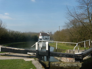
- But the main walk : go over the footbridge and continue straight along the main canal, sign-posted ‘Braunston, 55 miles’. You are now at Lock 45 (Marsworth Top Lock). Counting this as the first set, continue to the sixth set (Lock 40).
- [2] Here,leave the towpath and go up to continue on a higher parallel path on Marsworth Reservoir bank. In 90 metres bear left and after a further 15 metres, by a Tring Reservoirs information board on your left, fork right along the right-hand side of the second (Startops End) reservoir, still parallel with the canal.
- Ignore a downwards right fork in 30 metres and continue on a grassy path to the reservoir corner. Facing the Anglers Retreat pub ahead (which is across a road), turn left to follow the reservoir bank, parallel with the road. After 200 metres, at the next reservoir corner turn left along its third side for 300 metres, then carry on over a wooden bridge.
- Go left with the path, past a ‘Tring Reservoirs Walks’ guidepost. After a few twists this leads in 20 metres to wooden steps up to a road. With great care, cross directly to the other side, where a new path takes you right along another reservoir (Tringford), your direction 260° initially.
- In 50 metres you come to a sign on your left giving information about the area. A further 50 metres on, cross a wooden bridge. In another 60 metres, the path reaches the end of the reservoir and continues in the same direction through some trees, down some steps and curves sharply around to the left. 40 metres further on [!] turn right up a path towards a kissing gate, your direction 250°. Past the gate, walk straight across the small field in the same direction.
- In 40 metres go through a wooden kissing gate and turn left along the road. In 25 metres you pass Tringford Farm on your left and 100 metres further on come to a T-junction.
- To avoid walking around the large third reservoir - the Wilstone Reservoir - and instead to enjoy a further leg beside the Wendover canal, at this T-junction turn left . In 200 metres as you head towards Little Tring farm, join the canal towpath on your right. You now stay on this way, in places a towpath, in places a footpath where the canal has virtually dried up or become overgrown. In some 2.15 km you re-join the Main Directions after the bridge for the A41 by-pass, where you turn up steps. This walk option reduces the length of the main walk by a little over 1 km.
- For the Main Walk and your walk around the Wilstone reservoir, at the T-junction Turn right here, and follow this road for 500 metres. Just before a T-junction, you pass Wilstone cemetery on your right (worth a visit - amongst the graves are 2 maintained by the Commonwealth War Graves Commission - one First World War, one Second World War).
- [3] Turn left down the car-wide track next to the T-junction, passing a metal barrier. In 300 metres you come to a clump of trees, with a sign a few yards ahead for Wilstone Reservoir Nature Reserve. Turn right, your direction 340° initially. 70 metres further on, you come to a reservoir .
- Walk along Wilstone Reservoir bank, continuing in the same direction as before. Follow the first corner around to the left and walk all the way along the second side, which initially parallels a road down below on your right. 100 metres from the end of the second side the path crosses over a concrete bridge. In a further 100 metres cross another concrete bridge and then veer left through trees, initially along the third side of the reservoir, with a wire fence on your left hand side. 200 metres further on, at a junction in the path, there is a sign with information about the reservoir.
- At this junction, take the path to the right , your direction 180°. In 8 metres ignore a stile going off to the right and, 10 metres further on, pass through a wooden kissing gate ahead of you, then take the fork going to the right of the tree dead ahead. In 15 metres, branch off half right across the field, your direction 195° initially, towards the far corner of the field.
- In 30 metres, you pass under electricity lines and, in a further 170 metres, pass through a metal kissing gate with a public footpath sign. Cross the next field diagonally to the left, aiming for a point to the left of the row of houses opposite, your direction 200°. In 220 metres pass through the metal kissing gate 50 metres to the left of the end house and walk across the next field half-left. You pass through a metal kissing gate in 60 metres, which brings you onto a road.
- Turn left on to the road and in 30 metres [!] turn right through a rusty kissing gate, following the public footpath sign. Cross the field half-left, your direction 170°.
- After 180 metres go through a wooden kissing gate onto a drive. Turn right and after 20 metres bear left on the drive. In another 30 metres ignore a wooden kissing gate off to the right and continue through a metal kissing gate to the right of a metal fieldgate along the drive to the church of St Mary the Virgin, Drayton Beauchamp (generally kept locked) [4].
- Enter the churchyard through a metal kissing gate. Turn right just before the church to walk towards a rusty kissing gate and footpath sign 20 metres away. Pass through the gate and cross the field, your direction 260°, to go through a wooden kissing gate in the fenceline ahead.
- Beyond the gate, follow the path, which twists and turns through a wooded area to another kissing gate and after another 60 metres to steps descending to a canal path. Turn right, passing under a bridge (marked with a black plaque stating that the burial site of a Saxon princess was found nearby) and the A41. On the far side of the bridge, turn right to take steps up the river bank. At the top of the steps, by a footpath sign, turn right, then left along an enclosed path. In 70 metres pass through a kissing gate into an open field.
- Follow the footpath sign and keep to the right-hand side of the field beside a fence, then in 150 metres, by footpath signs attached to a fence, part hidden in the hedgeline on your right, you have a choice - walk for 850 metres directly across the potentially muddy fields, or walk around their perimeter.
- If you do not want to cross the potentially muddy fields, or you are unsure about the direction to take, then you can continue along the field edge for a further 80 metres until you reach the field boundary. Here turn left and follow the field boundary ignoring all ways off to your right and heading towards houses in front of you. After 600 metres you will reach a road and here turn right and in 700 metres resume the directions at [*] below.
- To follow the main route across the fields in more detail: At the prominent green metal footpath sign bear left across the field, keeping 15 metres to the right of a telegraph pole, your direction 300°. In 100 metres you reach a footpath sign and field boundary. Cross through a broken hedge into the next field on a car-wide section over a ditch. Cross the next field heading for a 20 metre gap between a telegraph pole and a hedge, your direction 290°. There is a footpath sign on a post to your right. Then keep straight on across another very large field for 550 metres, heading for a house with a white wall, which is by the corner of a field leading to a road.
- [*] Turn right along the road and, in 30 metres, you come to a crossroads, with an old pub sign (the ‘Rothschild Arms’) in the garden to your right-hand side [5]. You go straight across the B489 to follow the sign that says ‘Buckland village only’.
- In 125 metres you pass Nields Farm on your left and, in another 50 metres, you pass Manor Farm on your right. In a further 50 metres, turn right into Peggs Lane and, in 10 metres, go left through the lychgate of All Saints Church, Buckland, worth a visit.
- Turn right and then left around the church (or after visiting the church turn left and left again, your direction 330°) through the churchyard. Exit the churchyard through a tall wooden gate with a footpath sign into the field beyond, to go straight on, your direction now 340°.
- In 25 metres you pass a timber-framed house, 40 metres away on your left-hand side. In a further 35 metres go through a wooden swing gate and turn left in the field, your direction 315°. In 20 metres keep ahead, slightly right , across a field, on an indistinct path, aiming for the kissing gate in the field boundary ahead of you. If this field is in crop, walk around the field boundary, initially turning left.
- In 100 metres go through the metal kissing gate and over a short plank bridge over a ditch to come out onto a road, where you turn right, your direction 350°. In 15 metres [!] turn left down a signposted, narrow path that is hidden by a hedge as you approach it, which goes along the side of Juniper Cottage (to the right of the tall hedge which separates it from Moat Farm), your direction 300°.
- In 30 metres, go through a metal swing gate, then turn half-left, your direction 270°, keeping on towards the left-hand corner of the field. At this corner, carry straight on, coming to the hedge ahead. Here you bear left, with the hedge now on your right-hand side, your direction 240°.
- Carry on to the far corner of the field and go through a metal swing gate and under mini-pylons. The field hedge is now to your left-hand side, your direction 235°. In 130 metres, you come to a one-plank footbridge with a metal railing in the field corner.
- The Original Route (diverted) The original route had you turning sharp right here, your direction 335°, to walk along the second side of the field.[!] However, the fields ahead have now been built on by developers Bellway and the original footpaths have been diverted. Whilst it is now possible (Summer 2021) to walk through the new housing estate on diverted paths which eventualy connect up with Sunny Brook it is easier to take the diversion put in place during the construction of the housing estate to get to your lunchtime pub.
- The Diversion At the one-plank footbridge, cross it and keep ahead on a footpath through a lightly wooded area. In 100 metres come out of the woodland and keep ahead on a gravel pedestrian path, with new homes to your right. In a further 125 metres you continue now between wooden fences. In 80 metres you come to the Partridge Inn a weekends only beer drinkers watering hole. Now turn right into Green End Street. Keep ahead along this road, ignoring all roads off, as you pass the Clinton Baptist Church on your right-hand side. Some 250 metres down this road, as the road swings to the left, you come to the Oak pub , your lunchtime stop.
- After lunch, walk through the pub car park to the road and turn left. Follow this road for 500 metres, ignoring College Road off to the right. When you get to the T-junction at the A41 you will see the village war memorial straight ahead of you on the other side of the road, with a bungalow behind it. There is a pedestrian crossing 20 metres to your left which you should use to cross the road. Head back a few metres and walk down a marked public footpath that goes down the left-hand side of the bungalow.
- In 80 metres the path curves around to the left, your direction 170° initially, and 70 metres further on you come out into an open space and continue with a new office and warehouse development on your right. After a further 100 metres, you come to a house with a wooden fieldgate (saying ‘Rookery Farmhouse’).
- [7] Turn right just before the gate, following a footpath sign, into an enclosed path, your direction 250° initially. In 50 metres you enter a field. Carry on in the same direction as before for a further 150 metres until you reach the edge of a large airfield. Walk out into the open. You will see a sign saying ‘Caution. Ministry of Defence airfield.’ Turn left to follow the public footpath along the left-hand edge of the airfield, with a new post and rail fence on your right, your direction 170° initially.
- Continue with a small brook on the left-hand side of the path. Ignore a small bridge with a footpath sign to your left. At the corner of the airfield after 750 metres, ignore a small bridge (made of wood and metal) crossing the brook to the left. Instead, you follow the narrow path that continues ahead of you and along the right-hand side of the brook, your direction 120°.
- Carry on for 450 metres passing first trees and a sewage works on your right, then a patch of trees to your left, before meeting trees on both sides. The route is well signed by footpath posts with yellow arrows at regular intervals along the way. Bear left to pass between four large wooden posts, then turn right and in 70 metres cross over a brick bridge (Harelane Bridge), which spans the Wendover Arm Canal.
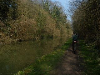
- On the far side of the bridge, descend to the left, down steps to the towpath.
- [**] At the bottom of these steps, turn left at this point if you want to take a short cut along the canal into Wendover. You proceed beside the canal for just over 2 miles, passing four bridges on your way. The first of these bridges is the wrought iron Rothschild bridge, painted blue and sporting the monogram A de R. This bridge connects the RAF offices mess on the left-hand side of the canal with the airfield on the other side. The mess is Halton House, as shown on the OS sheet, with the appearance of a fairytale chateau, built by Alfred de Rothschild in 1880. The fourth bridge is a thin plank footbridge, which replaced a railway bridge built by German POW's in 1917. The railway's disused path can be seen on the other side of the canal. The canal finally comes to a dead-end at a fifth bridge, where you walk up to the road and turn right down to the T-junction with the A413 road, to turn left, to resume the main walk's directions into Wendover.
- The main route is to turn right along the towpath and walk along with the waterway on your left-hand side. In 750 metres the waterway narrows markedly and, 100 metres further on, you come to a wooden post with ‘Green Park’ written on it and a sign entitled ‘The Wendover Arm’ giving information about Cobblers Pits and the woodland which you are about to enter.
- Turn right off the towpath, through a galvanised-iron kissing gate leading you into the wood (due south initially).
- Keep straight on, gently uphill, ignoring ways off. After 200 metres you reach a fork. Take the left path and continue on, steadily up the hill, ignoring the Permissive Ways oof to youir lefdt and right. In 300 metres you go through a metal kissing gate at the top of the path, and come out on to the A4011.
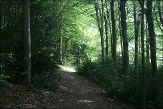
- [8] Directly opposite, a road leads straight ahead up a hill, with a green Forestry Commission sign next to it saying ‘Chiltern Forest Wendover Woods’. Cross the A4011 and walk straight up the road ahead. In 25 metres turn right off the road, through a gap in the metal fence on to a path leading into the forest (due south initially).
- In 250 metres, fork left uphill, following a horseshoe on a post, your direction still due south. In 250 metres, cross a surfaced track, and keep on, again following a horseshoe on a post, your direction 200° initially. In 100 metres, at a path crossing, where down to your right is a children’s pond dipping area bordered by a wooden fence, you keep ahead, through the woods.
- Continue and, 400 metres further on, you come to a crossing with a wider path marked by a horseshoe sign. Cross straight over, continuing down for a further 40 metres until you drop down to a car-wide track.
- Turn left on to the car-wide track, your direction 120° initially. In 200 metres the path bends round to the right and starts to go uphill, now in a shallow cutting, with woodland to your left and right. You are now ascending the eastern flank of Aston Hill. After 400 metres of walking uphill, you go over a cross paths with flint retaining walls to the paths on your left and right. Keep ahead, still within a cutting. In 80 metres the track curves around to the right and in a further 60 metres, [!] as the main track swings to the right, by a footpath post on your left with various signs, you keep ahead, straight on up the hill.
- In 300 metres, the path curves round to the left at the top of the climb and, 60 metres further on, you come to a wooden swing barrier leading out on to a tarmac track.
- [9] Turn right and walk along the tarmac track. In 60 metres, you come to a large two-armed wooden sign pointing left to the Chiltern Hills’ highest point and straight ahead for information and parking. Go left onto the gravel pathway running parallel to the tarmac.
- Since the building of the new, large car park on your right, and the new cafeteria building over to your left, the original route detailed below, which takes you down through some light woodland once you have passed the Go Ape centre is not quite so easy to follow. Try the following instead. Keep ahead to pass the new cafeteria over to your left. Now keep ahead on the earthen car-wide track which heads in a south-westerly direction to the right of the main Go Ape attraction. Keep on this track which gently descends and you eventually arrive at the barrier where the main route continues by the "Discover Boddington Hill Fort" information board.
- The original route: in 80 metres you pass just to the right of the new cafeteria Café and a further 30 metres on, you meet a tarmac road. Cross the road, slightly to the right , and take the crescent shaped gravel path ahead (not the path 25 metres to your left). Follow the curved path around to the right, passing a scenic viewing spot on your left after 30 metres. When you reach the junction with a tarmac road, at a right-hand bend in the road, [!] turn left onto a track, your direction 230°, passing a ‘Go Ape’ hut immediately on the left.
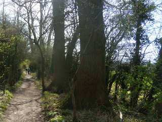
- Carry on this track, past various tree ladders on your right-hand side until after 200 metres you reach a sharp right bend. At this bend, and 20 metres before a wooden pillar post marked ‘Caution: cables overhead’ [!] turn left down the footpath marked "the Firecrest Trail", going through wooden barriers, into woodland, your initial direction 200°.
- Follow the path as it meanders gently downhill through light woodland, ignoring all ways off and going over cross paths. After 250 metres you come out of the woods with an open green space ahead, parallel to a broader track 15 metres to the right. Cross over to this track, and turn left onto it, your direction 220° initially.
- In 250 metres, you come to a small grass roundabout and a wooden barrier, dead ahead, with a marker saying ‘Boddington Hill ¾ mile’ and over to its left a "Discover Boddington Hill Fort" information board. [10].
- Go straight on past the barrier. 10 metres beyond it, ignore a fork to the left. In 70 metres [!] by a footpath marker, there is a path going off to the right diagonally down the hill. Take this path, your direction 280° initially.
- If time permits, you can continue along the main track to explore the remains of the fort and in 150 metres enjoy the views from the hilltop over the Vale of Aylesbury but you will need to retrace your steps to this point.
- 10 metres on, you reach a path crossing.Take the path ahead, slightly right, downhill , your direction 260° and after a very steep descent of about 300 metres on a chalky path which can be very slippery, you come to a crossing with a bridleway. Continue straight across down the hill, your direction 305° initially. In 30 metres you come to a tarmac lane with the entrance to a house on your right.
- Turn left on to the lane, your direction 270° initially, with a fine view of Coombe Hill and its monument ahead to your left. In 300 metres the lane comes out into a residential estate [11], and you continue straight on in the same direction along Barlow Road.
- In 40 metres you cross over Wolverton Crescent to your left and continue straight on. In 100 metres you come to a crossroads, again with Wolverton Crescent to your left (and with Hampden Road going straight on) and you turn right, by the red letter box in the wall, down Colet Road. In 100 metres, this takes you down to a service road running parallel to the A4011.
- Cross the service road and cross over the main road (the A4011). Turn left on the A4011, your direction 225°, and in 15 metres turn right on Manor Road, your direction 310°. Follow this road, ignoring all ways off. In 250 metres cross the bridge over the southern end of the Wendover Arm Canal (the short cut along the canal rejoins here). In a further 160 metres, at the A413 junction, turn left, your direction 150°.
- In 200 metres you pass the George and Dragon pub and Thai restaurant on your left-hand side and, in a further 10 metres, by the clock tower, follow the A413 right, your direction 230°. This is Wendover High Street. In 70 metres you pass the Red Lion Hotel on your left-hand side (which serves tea).
- Continue up the hill, ignoring a road to the left in 50 metres (signposted ‘library’). 50 metres beyond this, Rumsey’s Chocolaterie , one of the suggested tea places, is on the right-hand side (located in an old brick building that used to house a bank).
- 80 metres on, you reach a road to the left signposted ‘A413, London and Amersham’. To get to the railway station, continue on up the High Street, and in 70 metres you pass the Shoulder of Mutton pub on your right-hand side, another suggested tea place. Immediately after that, Station Approach leads down to Wendover Railway Station [12]. The platform nearest to you is the one for London.