Farnham to Godalming walk
A long but pretty walk with gentle hills via a nice mixture of river valley, forest tracks, and many beautiful country houses.
Farnham to Godalming
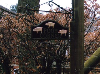
Pooh Corner. Follow the 3 pigs to find The Donkey!? D.Allen Vivitar 5199 5mp
Jan-06 • magyardave2002 on Flickr
england corner surrey pooh book1 walkers walk12 swcwalks 436684780

'Pooh Corner' on the Farnham to Godalming walk
Conundrum: Follow the 3 pigs to find The Donkey!? D.Allen Vivitar 5199 5mp
Jan-06 • magyardave2002 on Flickr
england corner surrey pooh book1 walkers walk12 swcwalks 13408568635

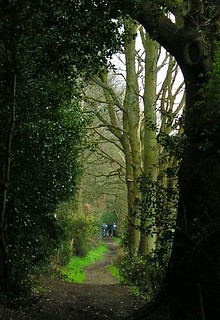
Book 1, Walk 12, Farnham to Godalming 1
Keeping people out - in an attractive kind of way, 24 March '07.
book1 godalming farnham walk12 swcwalks tocw112 433859679
Book 1, Walk 12, Farnham to Godalming 2
Close to Tilford, 24 March '07.
book1 godalming farnham walk12 swcwalks tocw112 433855739

Book 1, Walk 12, Farnham to Godalming 3
Boots at The Donkey, 24 March '07.
book1 godalming farnham walk12 swcwalks tocw112 433855326
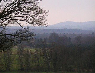
Book 1, Walk 12, Farnham to Godalming 4
A view from Peper Harow, 24 March '07.
book1 godalming farnham walk12 swcwalks tocw112 433853272

Book 1, Walk 12, Farnham to Godalming 5
Peper Harow, 24 March '07.
book1 godalming farnham walk12 swcwalks tocw112 433851046
River Wey, Waverley Abbey & Peper Harrow Park
| Length | 21.23km (13.19 miles), 6 hours. For the whole outing, including trains, sights and meals, allow at least 9 hours. |
|---|---|
| Toughness | 5 out of 10. |
| OS Maps | Explorer 145 or Landranger 186. Farnham, map reference SU 846 455, is in Surrey, 15km west of Guildford. |
| Features |
This walk starts and ends along the River Wey. It follows the start of the North Downs Way through a narrow forested valley. It passes close to the ruins of Waverley Abbey (English Heritage), and goes through woods to The Donkey, the suggested walker friendly lunchtime pub in Charleshill (but see below - Lunch - this pub CLOSED March 2024). After lunch, there are further sandy bridleways through woods before entering the open parklands of the Peper Harrow estate which has its own church and cricket pitch. Then along a narrow wooded valley beside the River Wey to tea in Godalming's ancient centre. The majority of this walk is within shaded woods, hence it can be undertaken on a hot summer's day without feeling uncomfortable. Conversely, because many of the paths (particularly after lunch) are sandy bridleways, the walk tends not to be as muddy as other walks can be in winter, so provided you leave enough time to complete the walk in daylight, you can try it on a winter's day. |
| Walk Options |
You can mix-and-match this walk with the TO Book 2 Walk 12 and return to Farnham by a differernt route after the lunch stop at the Donkey pub in Charles Hill, making for an enjoyable circular walk of 10 miles. You can book a taxi from either of the lunch pubs. The No 46 bus, from Farnham to Godalming, with a once every two hours service, Monday to Saturday (no Sunday service), stops in Tilford. Check at the village store or pub for the location of the bus stop if it is not obvious. |
| History |
The town of Farnham (the name derives from the Saxon for 'ferny water meadows') prospered through trade in corn, wheat and hops. Its Norman castle was built by Henri de Blois, a grandson of William the Conqueror. Moor Park House is the site of the 1897 Moor Park Riot where a crowd successfully forced open the gates to maintain the right of way against the intention of the owner, Sir William Rose. During World War II Moor Park was part of the General Headquarters Line of defence built against an expected German invasion; remains such as pillboxes and gun emplacements can still be seen in the Park and surrounding area. The twelfth-century Waverley Abbey (English Heritage) – now in ruins – was the first Cistercian monastery to be built in England. The Abbey was founded by William Gifford, Bishop of Winchester, in 1128. The Abbey was built on a floodplain, surrounded by current and previous channels of the River Wey, hence during its lifetime the Abbey was freqently flooded. Following the Dissolution of the Monasteries in the 16th century the Abbey was part dismantled before it fell into ruin. But the structures left in situ are worth a visit, and if you access the Abbey's website you can download an audio tour of the Abbey onto your iPad or mobile, which tour starts in the car park, some 350 metres away from the main buildings. Access to the site is free, and the site is open all year round during daylight hours. The Peper Harrow Church of St Nicholas is a Norman building restored by Pugin, the Victorian architect. It contains a memorial to Vice Admiral Thomas Brodrick; he helped to court-martial Admiral Byng, who in 1757 was shot on the quarterdeck of his own ship as a scapegoat for the navy's failure to save a besieged garrison on Minorca or, as Voltaire put it, 'pour encourager les autres'. You might be lucky and find the church open (although it is usually closed except on a Sunday) but visits can be arranged through the church warden - 'phone 01483 810 526 . Godalming is thought to mean 'field (-ing) of Godhelm' (the putative first Saxon to claim the land). It was a coaching town between London and Portsmouth, and a centre of trade in wool, stone-quarrying, timber, leather, paper, corn and brewing. The High Street has many half-timbered buildings. |
| Travel |
Take the train nearest to 9.30am from Waterloo Station to Farnham (perhaps changing at Woking). Journey time about one hour. There are trains back from Godalming every half hour (hourly on Sundays). Journey time 50 minutes. Buy a day return to Farnham. For the return journey you will also need to buy a single from Godalming to Guildford. By Car : Train is easier for this one. Change at Guildford or Woking to return to your car. You can park for free near Farnham railway station at weekends. |
| Lunch |
The first pub you pass, some 4 miles into the walk, is the homely, attractive and walker-friendly Barley Mow pub (tel 01252 792 205) in Tilford. The pub, described as a "quintessential English Country pub" dates from 1705 and enjoys a riverside garden and overlooks Tilford Green, where cricket is played during summer months. The pub won the Best Surrey Pub for Food and Drink award from Surrey Life Magazine in 2018. Locally sourced, high quality food is served from 12 noon to 3 pm, Tuesday to Sunday (no lunch service in winter on Mondays). The pub also has an extensive wine list and has a good range of beers. Groups of more than 6 people are advised to book. The traditional lunch stop for SWC walkers some 2.75km (45 minutes) after the Barley Mow, was The Donkey (tel 01252 702 124), a walker-friendly pub in Charles Hill, just under half way into the walk. This pub COLOSED in March 2024 when the long term licensees retired. The owners have put the freehold up for sale - hopefully as a pub - but a chancer-punter-developer might try to obtain consent for change of use to residential. More details will follow as the situation develops. In the meantime the SWC lives in hope the pub will reopen as a pub under new ownership. |
| Tea |
For a very late lunch, or an earlier tea stop for a stronger drink or light refreshments, try the Stag on the River pub in Eashing (tel 01483 421568) which as its name implies enjoys a pleasant mill-stream, riverside setting. The suggested tea stop in Godalming is the Cafe Mila (tel 01483 808569) in Angel Court, just off the High Street, which is open until 5pm Monday to Saturday and 4pm on Sunday. The ground floor is the family area and upstairs reserved for adults. Other tea options include the usual suspects such as Caffè Nero and Costa Coffee. Another good tea stop is Changing Perceptions Community Cafe and Workshop (tel 01483 420436) at 133A High Street. Open until 5pm Monday to Friday, to 4.30pm Saturday, closed Sundays. This community project offers training and employment opportunities for those with disabilities. Its cakes in the cafe section are reported to be delicious. For an alcoholic drink at walk-end, the pub frequented by SWC's beer connoisseurs is The Star on Church Street. The pub also serves food (their burgers are recommended) after 5 pm. |
| Updates | No major changes. New tea stop added May 2018. Additional details on Waverley Abbey added - and details of lunch pubs updated March and October March 2019. This edition and book check February 2022. |
| Book |
This walk was originally published in Time Out Country Walks near London volume 1. We now recommend using this online version as the book is dated. The book contained 53 walks, 1 for every week of the year and 1 to spare. Here is our suggested schedule |
|---|---|
| Profile | |
| Help Us! |
After the walk, please leave a comment, it really helps. Thanks! You can also upload photos to the SWC Group on Flickr (upload your photos) and videos to Youtube. This walk's tags are: |
| By Train |
Out (not a train station) Back (not a train station) |
| By Car |
Start GU9 8AD Map Directions Return to the start: Finish GU7 1EU Map Directions Travel to the start: |
| Amazon | |
| Help |
National Rail: 03457 48 49 50 • Traveline (bus times): 0871 200 22 33 (12p/min) • TFL (London) : 0343 222 1234 |
| Version |
Apr-24 Marcus |
| Copyright | © Saturday Walkers Club. All Rights Reserved. No commercial use. No copying. No derivatives. Free with attribution for one time non-commercial use only. www.walkingclub.org.uk/site/license.shtml |


Walk Directions

- [1] Coming off platform 2 at Farnham Railway Station, with the Waverley Arms on your right-hand side, cross over the railway lines, your direction 330°. In 20 metres you pass a petrol station on your right and head down Station Hill.
- In 100 metres you reach the A31 dual carriageway. Turn right here, your direction 250°, and, in 150 metres, fork right on a track signposted the North Downs Way. In 220 metres you come to a minor road. Turn right here and follow the road round to the left, uphill. There is a BP garage below you on your left with an M&S shop where you can buy a sandwich or bottled water.
- In 350 metres you are beside the River Wey (on your left-hand side). In a further 200 metres, you pass the entrance drive to Snayleslynch Farm on your right.
- In 100 metres, at the entrance of a house called the Kiln, go sharp right following the North Downs Way sign, your direction 120°. In 35 metres you go under the railway line. In a further 85 metres, ignore a footpath signposted to the right to go straight on with open fields on your left-hand side.
- In a further 220 metres, at a path T-junction, follow the North Downs Way footpath sign to the left, your direction 60°.
- In 65 metres ignore the wooden swing gate to your right (although do observe the carved wooden bench seat just beyond it), to go straight on. In 50 metres you cross the river on a wooden bridge with railings. Continue ahead and in a further 140 metres go through the gateway of High Mill (marked 'Private'), following the white-painted arrow, onto a gravel way. In 25 metres go over a small stream. In another 30 metres, you exit the property through high wooden gates, coming out onto a surfaced drive. Keep ahead and in 65 metres, at a T-junction, go right on a bridleway along a broad earth track, passing a pond on your right, heading due east.
- In 180 metres ignore the tarmac access road beyond barriers uphill to your left (entrance to Kilnside Farm). and in a further 20 metres go around a metal field gate otherwise blocking your way. Now follow the lane half right your direction 150° and in 200 metres you pass Swift's Cottage and Temple Cottage on your left-hand side. In a further 220 metres ignore a tarmac lane going uphill on your left. In 160 metres [2] cross a tarmac road to go through the metal kissing gate to the left of the entrance gateway to Moor Park House your direction 135°.
- In 50 metres notice the ornate gatehouse to Moor Park House on your right but keep straight on: you are now on the Moor Park Heritage Trail . In 600 metres, having earlier passed through a wooden kissing gate to the left of a metal barrier, you pass a WW2 pillbox on your right-hand side and in a further 100 metres you pass another pillbox with a noticeboard about Moor Park in World War II. In 450 metres you pass Mother Ludlam’s Cave on your left. In 85 metres go through a metal kissing gate. In 40 metres you pass Stella Lodge on your left-hand side to come out on to Camp Hill road [3].
- Go right on this road downhill for 20 metres, then left on a road, signposted to Godalming, your direction 145°. In 185 metres, as the road swings to the left, take a public byway on your right, a broad earth track, your direction 185°.
- In 200 metres, in winter, you can see Waverley Abbey House away on your right-hand side and the ruins of Waverley Abbey, due west (300 metres to the left of the house).
- If you would like to detour for a closer view of the Abbey, in 110 metres take a path down to your right between yew trees and rhododendrons; in 150 metres, you are beside the River Wey, with the Abbey ruins opposite to the left.
- Continue on the main path, gently uphill. In 115 metres, where the path starts to descend and there is a metal gate on the left [!] go sharp right up the hill, following a public byway sign, your direction 230°.
- In 370 metres you cross a tarmac road (with a brick post box opposite) to continue on a gravel road with a public byway sign, your direction 230°.
- In 40 metres fork left following a red arrow on a low wooden post, your direction 190°. In 10 metres you pass Sheephatch Farm (marked on the OS map) on your left. Keep to this path, a broad car-wide track, ignoring ways off. In 450 metres you pass the entrance drive to Tilhill House on your left-hand side, to continue straight ahead, now on a tarmac lane.
- In 130 metres, just before the entrance to Wey Cottage, [!] fork right off this lane on a signposted public bridleway, your direction 170°. In 20 metres ignore a stile on your left-hand side. You are back near the River Wey on your right. In a further 185 metres, ignore a path going up to the left.
- In 285 metres you come to the main road, with Tilford Village Shop on your left-hand side, where you can buy hot drinks, sandwiches and provisions for a picnic. But if you want to stop for an ealy lunch now, turn right over the bridge, to the Barley Mow pub , Tilford, on your right-hand side. Note the pub en route 45 mins later into the walk - the Donkey - has CLOSED as of March 2024 and is up for sale. So if you want a pub lunch on this walk head for the Barley Mow.
- To continue on the main route: go left, your direction 45°, passing the Village Shop on your left. In a further 210 metres, ignore Whitmead Lane to the right. In 75 metres, as the road bends sharply to the left, cross over to take the tarmac lane to your right, your direction 125°, passing a house on your left.
- [4] In 75 metres take the public footpath signposted left (a tarmac road), your direction 60°.
- In 150 metres, at the end of this driveway, by the entrance to Archers Hill house, fork right on a public footpath, following a yellow arrow.
- In 400 metres, you reach a metal gate. Immediately turn left and follow the path ahead and around a garden to emerge on tarmac road next to Pooh Corner House. Here go right on the road downhill, your direction 190°, with Highmead House on your left-hand side.
- In 240 metres, by the entrance drive to Whitmead House, fork left on a vehicle-wide byway, your direction 95°, with a timber-framed lodge house on your right-hand side.
- Keep ahead on this pleasant woodland track and in 950 metres you pass the entrance to West Wey House on your right-hand side. In 80 metres, at a crossing of lanes, fork right, downhill, your direction 95°. In 30 metres you pass the entrance to Riversleigh Farm on your right. In a further 55 metres, you come to the suggested lunchtime stop, The Donkey pub in Charleshill, on your right. But NOTE as of March 2024 this pub has CLOSED following the retirement of the long term licensees.
- Coming out of the pub after lunch, turn right. In 55 metres you reach the main road. Cross this and take the public bridleway signposted tarmac lane straight on (the entrance to Foxhill is on your right-hand side), your direction being 345°.
- For those on a Farnham Circular Walk, stay on this bridleway at this point and now follow the Directions in Book 2, Walk 12c).
- Continuing on the Book 1 Walk, in 35 metres [!] turn right , following the bridleway sign, to go uphill , initially through scrub, rhododendron bushes and undergrowth, your direction 65°. In 215 metres, your way becomes a tarmac drive. In 210 metres you pass black iron gates on your right-hand side, to fork left, your direction 60°, on a tarmac way. There is a low column with an entry phone on your left-hand side.
- [5] In 80 metres you exit through the Three Barrows gateway to cross a tarmac road and go straight on, your direction 70°, along a signposted public bridleway, ignoring field gates off to the left and right-hand sides.
- In 800 metres, by the entrance drive to Fullbrook Farm, you come out on to a tarmac road and cross it to continue straight on towards Broomfield Cottage (private), on a gravel drive, your direction due east.
- [6] In 170 metres, by a turning circle or parking area on your right-hand side, [!] turn left through a swing gate, to follow the direction of a public bridleway, half-right, diagonally over an open field. In 25 metres you pass the first oak tree, on your left-hand side, your direction 60°, and keep going in this direction, ignoring all ways off. Aim for 30 metres to the left of the right-hand corner of the wood, some 400 metres ahead of you.
- Enter the wood by a wooden swing gate, and continue on, your direction 65°, along a potentially muddy way. In 60 metres cross a stream on a bridge with wooden railings. In a further 170 metres, you come to a tarmac road by a bridleway sign where you turn right, your direction 110°.
- In 60 metres go over a stream. In a further 30 metres, by a footpath sign opposite Brookside House, turn left, your direction 20°.
- In 190 metres you come to a tarmac road T-junction where you go left, with Kingshott Cottage on your left-hand side, your direction 55°. In 45 metres follow the blue arrow straight on, now on a broad sandy way, ignoring a fork left to Broad Firs. In a further 220 metres, ignore a way off to the right (with a field gate also on your right-hand side). In 200 metres ignore ways off to the right and left. In 150 metres ignore a post with a blue arrow to the left (indicating a bridleway) to follow the blue arrow straight on. In 30 metres ignore a way to the right.
- [!] In 275 metres [7],5 metres before a post with red arrows to the left and ahead, go right on an unmarked path, gently downhill, your direction 190°.
- In 60 metres fork left, through woodland, gently downhill. In 260 metres you come out on to a tarmac road where you go right, your direction 215°. In 40 metres you pass the entrance to Prospect House.
- In 55 metres, go left on a sandy road, signposted public bridleway, through woodland, your direction due south.
- In 240 metres, ignore a path to the left. In 65 metres cross a stream.
- In 70 metres, at a T-junction, with a cottage on your right-hand side and a wooden field gate ahead, go left, your direction 80°.
- In 240 metres go straight on where an unmarked track crosses. In 85 metres, within 20 metres of the end of the wood, at a junction, keep ahead (slightly right) , your direction 125°, with the wood on your right-hand side.
- Keep to this main, sandy path, ignoring all ways off. In 360 metres you come to a tarmac road where you turn right, your direction 195°.
- In 45 metres you pass Headlands House on your right-hand side. In a further 240 metres, you come to the main tarmac road.
- Turn right and, in 40 metres [8], turn left off the road, following the public footpath sign down the tarmac road into the Peper Harrow Estate (which is marked on the OS map).
- In 160 metres ignore a kissing gate and signposted path to the right. In 30 metres, ignore a fork to the right by a post box. After walking a further 200 metres, you come to the Church of St Nicholas Peper Harrow (usually kept locked, but when open well worth a look inside).
- In 30 metres [!] bear left off the estate road, passing by a metal fieldgate and out onto a signposted public footpath over an open field, heading due east. In 30 metres you pass close to a wooden farm shed on your left-hand side and head to the left of the dark green coloured pavilion ahead, with no clear path.
- In 135 metres you pass the pavilion on your right-hand side and keep parallel and to the left of the mini-pylons, bearing slightly left as you proceed over this field. On its far side enter the wood, some 35 metres to the left of its right-hand edge, going through a metal kissing gate.
- [9] In 40 metres, exit the wood on its far side, coming out to a path T-junction. [!] Ignore the metal kissing gate and footpath straight on and instead turn right, in 8 metres going through a small metal swing gate with a bridleway sign, where you turn left, along the edge of a field with the field fence on your left-hand side, your direction 70°.
- In 150 metres veer right with the bridleway, a field fence still to your left, over the field.
- In 235 metres go through a metal field gate, head down a track and then cross the A3 on a bridge. On the other side, go right downhill towards a petrol station. In 80 metres turn left on Lower Eashing Road, your direction 120°.
- In 40 metres turn left between Greenways and Lower Eashing Farm Cottage on a tarmac road, which is a signposted public bridleway, your direction 40°. However , if you wish to take refreshments at the Stag on the River pub in Lower Eashing, keep ahead on Lower Eashing Road, to cross the traffic light controlled single carriageway bridge over the River Wey in 200 metres. On its far side, swing right with the road and you come to the Stag on the River pub in 100 metres on your right hand side. Retrace your steps afterwards to the left turn between Greenways and Lower Eashing Farm Cottage.
- In 40 metres this tarmac road becomes a concrete road, passing Greenways Farm and Stable on your right-hand side. In 120 metres, with a pillbox down on your right, ignore a path off uphill to your left. In 75 metres, you pass under pylons.
- In a further 110 metres, where the concrete road turns left, go straight ahead through a wooden field gate on a car-wide earth bridleway, your direction 55°, in 10 metres passing a pillbox on your left.
- In 230 metres go under pylons (a potentially muddy area). In 110 metres you pass under two lots of pylon cables. In 245 metres ignore a path to the left, marked by a post.
- [10] In 30 metres you reach a T-junction, with a garden wall ahead. Here turn right, following a public footpath sign, your direction 145°.
- In 80 metres you go through a wooden swing gate (a wooden fieldgate and the entrance to Milton Wood on its right-hand side) and head down an entrance way, with a brick wall and flank wall to Milton Wood on your immediate right. In 90 metres you pass on your left "The Little Garage in the Lane" and keep on down what is now a earth path.
- In 150 metres go through a metal barrier, now alongside the River Wey, over and down to your right.
- Keep ahead on an undulating earth and sandy path which in places goes over planks and duckboards and up earthen steps. [!] Take care as you proceed along this path, which is in poor condition (winter 2021) and tends to be very muddy in winter. In addition, footbeds are uneven in places.
- Some 500 metres along this path you go through another metal barrier. In 40 metres [11], and one metre before the start of a tarmac road and a housing estate, [!] follow the public footpath signpost right, downhill, your direction due south.
- In 75 metres go over a concrete bridge, with a WW2 brick pillbox to its left, and in 8 metres ignore the signposted footpath to the left. Keep ahead and in another 8 metres, at a path junction bear left(ignoring the path to your right) and go under pylons, your direction 140°, with the River Wey on your right-hand side.
- In 45 metres you pass under more pylons. In 10 metres ignore a minor path to your right and keep ahead. In a further 20 metres the path swings to the left and you are back beside the River Wey on your right.
- Keep ahead on this riverside path and in 120 metres you go under more pylons and more again in 55 metres. In a further 120 metres after the path has been through bends your way merges with a tarmac path coming from the left and you continue ahead. In 150 metres cross a stream on a wooden bridge with wooden handrails.
- In 280 metres, you cross a concrete bridge with scaffolding pole railings. In 5 metres go through a metal barrier across an entrance drive and straight on, passing a red brick estate manager's office on your right hand side, with a stream on your left hand side.
- In 65 metres at a tarmac road go right, your direction 170°. In 20 metres go under the railway line . 10 metres after the bridge, fork right on a signposted public footpath. In 110 metres, having kept parallel to the road, cross the river on a wooden bridge with wooden railings.
- In 35 metres you are back on the main Borough Road and go straight on, in 65 metres reaching the entrance to the Church of St Peter and St Paul.
- If you want to go straight to the railway station without tea, turn right here down Deanery Place but instead of following Station Road, take the passageway straight ahead which takes you to the station.
- For tea, go left up Church Street which is a car road made of bricks (signposted ‘To the High Street’), your direction 125°. You pass on your right-hand side The Star , the recommended pub for beer lovers. A little further on up Church Street you come to the junction with the High Street, with the Old Town Hall ahead of you. Here turn left for Cafe Mila , Caffè Nero and Costa Coffee, and the Wetherspoons pub.
- After tea, retrace your steps to the church. Go back down the High Street and at the Old Town Hall, turn right down Church Street. When you reach the church go straight on to pick up the passageway ahead leading to the railway station.
- At Godalming Railway Station go over the new pedestrian bridge for the London-bound platform.