Gomshall to Guildford walk
Historic Shere, then a walk through a broad wooded valley, then along a canal to historic Guildford


Blackheath Forest & River Wey
| Length | 15.6 km (9.7 miles), 3 hours 50 minutes. For the whole outing, including trains, sights and meals, allow 7 hours 30 minutes. |
|---|---|
| Toughness | 3 out of 10. |
| OS Maps | Explorer 145 or Landrangers 186 & 187. Gomshall, map reference TQ 089 477, is in Surrey, 10km east of Guildford. |
| Features |
There is much that is ancient, beautiful and surprising to be enjoyed on this walk. It starts in Gomshall, passing some of the pleasant buildings on its outskirts, before crossing fields to the interesting church and village of Shere on the Tilling Bourne stream, a place packed full of fifteenth and sixteenth-century timber-framed buildings. Then the walk continues past old gnarled trees in Albury Park and through the pine woods of Blackheath Common. From there, the route follows the Downs Link path. There's an optional detour to visit Chinthurst Hill Tower, a folly with a view. The final stretch is along the River Wey into Guildford for tea at the Yvonne Arnaud Theatre. Short stretches of the Downs Link can be muddy. If you like horses this is a walk for you, as the route passes through several stud farms and a riding school. The original lunch pub has closed. The only alternative is close to the start, so you may like to bring a picnic. |
| Walk Options |
A longer morning route through Albury ParkThis option takes a loop through Albury Park instead of going along its edge. This takes you past an unusual Catholic Apostolic Church built for a new religious movement which originated in England in 1832. This is not open to the public, but in the middle of the parkland you can visit an unusual and interesting old Saxon Church. Much of this is very old but it also contains a 19thC mortuary chapel, designed by Pugin. The church was closed for 80 years but reopened in 1921 for occasional services; it is now maintained by the Churches Conservation Trust. After a climb through woodland you rejoin the standard walk route just before lunch. This option adds 2.4 km (1.5 miles) to the walk, so you reach the lunch pub after 6 km. Lunch pubWith the closure of the Villagers pub the only alternative after Shere (the start) is the William IV pub in Albury Heath, which comes after just 3½ km on the standard walk. This can be extended to 6km by taking the Albury Park option above. [!] But Note : as of September 2023 this pub has sudddenly CLOSED and is up for sale for £ 1.25 Million - an update will be provided when its futute has been ascertained. This is particularly awkward on a Sunday, because on the current timetable you will reach the pub before noon (or about 2pm if you take the next train on this two-hourly service). So on a Sunday your options are a picnic en route, or a very early lunch in Shere, or the optional loop of Albury Park. Chinthurst Hill Tower - folly and viewpointThis is a short afternoon detour to a viewpoint with fine views over the South Downs. It adds 0.6 km to the walk length. To shorten the walkTowards the end, you can take a shortcut to Shalford station which saves about 2.5km. However, it only has an hourly service. A Very Long WalkFor those who like to walk "long", precede this walk with #cw1.42 Holmwood to Gomshall, giving an overall walk of some 30.4 km (19 miles). |
| History |
Gomshall Station is where it is because, in the 1840s, the site for a railway station was decided on a given day by whichever shortlisted spot had the greatest number of people waiting. The publican at the Black Horse, Gomshall, provided free beer for those willing to wait at his site, as he wanted the station to be at Gomshall. Gomshall is detailed in the Domesday Book (1086) as having 'land for 20 ploughs, 30 villagers, 8 smallholders with 18 ploughs, 6 slaves'. Of Shere, it reports: 'Queen Edith held it. Now it does not pay tax - 19 villagers and 6 smallholders with 12 ploughs. A church. 6 slaves.' By the sixteenth and seventeenth centuries it had grown into a small township of perhaps 40 houses (most of which remain today) housing blacksmiths, wheelwrights, weavers and tailors. St James' Church, Shere, was built in 1190 (but its lychgate was designed by the architect Edwin Lutyens). It is a rare example of a church in the Early English Transitional Style (with the round Norman arches giving way to pointed ones). The nave pews have numbers - at one time people paid rent to the church for them. In 1329, anchoress Christine Carpenter was enclosed in a cell on the north wall of the church (receiving food through a grating on the outside wall) for three years. She then returned to the world before petitioning to be re-enclosed. The bishop consented: 'The said Christine shall be thrust back into the said enclosure that she may learn how nefarious was her committed sin.' The Alms Chest in the church dates from about 1200 and was used to collect money for the crusades fought in the Holy Land. |
| Travel |
Trains to Gomshall whether departing from Victoria (changing at Reigate) or London Bridge (changing at Redhill) or from Waterloo (changing at Guildford) are infrequent (every two hours) so you will have to decide whether to make an early start around 9.00 am or a late one nearer 11.00 am. Journey time by either route is a little over one hour. Returning, there are frequent trains from Guildford to London, 34-40 minutes if you catch a fast one (avoid the stopping trains which take twice as long). The rail ticket which usually works best is a day return to Gomshall-ANY ROUTE PERMITTED, which covers outward and return journeys via Redhill or Guildford. If driving, there are direct but infrequent trains between Guildford and Gomshall. Guildford station is closer to London and has a large car park, but you can park near Gomshall station for free. |
| Lunch |
Following the closure of the original suggested pub on this walk, the Villagers, in Blackheath, and its (controversial) conversion to residential housing in 2021, the suggested pub - when it reopens - will be is the William IV (tel 01483 202 685) in Albury Heath (some 3.5km from the start of the walk): the pub suddently CLOSED in September 2023 and is on the market for sale at an asking price of £ 1.25 Million. Details for the pub will be returned to this webpage when / if it hopefully reopens under new owners. With the current closure of the William 1V pub, your only pub options on this walk (without detouring some way off route to Shalford) come very early and at the start of the walk, after 1.6 km, in the pretty village of Shere , where there are two excellent pubs in the centre of the village. The White Horse , a Chef and Brewer pub (tel 01483 202 518), serves food all day from 12 noon. The William Bray (tel 01483 202 275) serves food from 12 noon until 3 pm weekdays, and all day on Sunday. |
| Tea |
The suggested tea place in Guildford is the cafe in the Yvonne Arnaud Theatre (tel 01483 569 334), open Monday to Saturday from 10.00 am to 3.30 pm, and on show days again from 5.30 pm (Closed Sundays). On Sundays you have the choice of several pubs. Two suggested are the White House pub (tel 01483 302 006), close to the river and St Nicholas Church, and The Britannia (tel 01483 572 160) also close to the river. |
| Updates |
This edition November 2021 following a book check. There have been minor changes and route detours since the 2011 edition of the TO Book, so suggest you use these on-line Directions. Lunch pub updates - and details of closure - October 2023. |
| Book |
This walk was originally published in Time Out Country Walks near London volume 1. We now recommend using this online version as the book is dated. The book contained 53 walks, 1 for every week of the year and 1 to spare. Here is our suggested schedule |
|---|---|
| Profile | |
| Help Us! |
After the walk, please leave a comment, it really helps. Thanks! You can also upload photos to the SWC Group on Flickr (upload your photos) and videos to Youtube. This walk's tags are: |
| By Train |
Out (not a train station) Back (not a train station) |
| By Car |
Start GU5 9NX Map Directions Return to the start: Finish GU1 4UT Map Directions Travel to the start: |
| Amazon | |
| Help |
National Rail: 03457 48 49 50 • Traveline (bus times): 0871 200 22 33 (12p/min) • TFL (London) : 0343 222 1234 |
| Version |
Oct-23 Marcus |
| Copyright | © Saturday Walkers Club. All Rights Reserved. No commercial use. No copying. No derivatives. Free with attribution for one time non-commercial use only. www.walkingclub.org.uk/site/license.shtml |


Walk Directions
- [1] If arriving at Gomshall Railway Station from Dorking Deepdene or Redhill, on platform 2, cross the new steel pedestrian bridge to platform 1. From Guildford you arrive on platform 1 (the side with the caravans on display). Leave the station and turn left downhill on the station approach road, your direction 240°.
- In 110 metres at the T-junction with the A25, cross over and turn left under the bridge using the pedestrian tunnel on the right, your direction 155°.
- 10 metres past the bridge, go right on the signposted public footpath, a lane called Wonham Way, your direction 225°.
- In 80 metres go across a bridge over the Tilling Bourne stream. In a further 80 metres you pass a house called Badgers Oak on your left.
- [2] In a further 50 metres, at a three-way footpath sign, turn right onto a bridleway (just before the gateway of Twiga Lodge and with the bridleway parallel to an earth farm road on its left), your direction 265°.
- In 130 metres the path merges with a farm track, coming in from the left. In a further 70 metres you pass a manor house on your right and a farm on your left.
- In 40 metres at a road T-junction, with a two-armed footpath sign on your left, turn right and in 20 metres go under the railway bridge.
- In 10 metres from the end of the bridge at a car road T-junction by a house (number 4), turn left, your direction 290°.
- Ignore ways off and in a further 190 metres, at the T-junction, with a bus shelter on your right, go to the right of the grass triangle, cross over the road and continue more or less straight on along Gravelpits Lane, your direction 295°, on a signposted public bridleway. In 35 metres the lane swings left, your direction 220°.
- [3] In a further 65 metres at a junction of paths, take the bridleway to your right, with Gravel Pits Farmhouse on your left, your direction 290°.
- Keep to the path, ignoring all ways off. You can see Netley Manor House (as marked on the OS map) to your right, northwards.
- In 500 metres at the corner of a field, with a footpath post on your right [!] turn right, downwards on a minor path towards the church, your direction 310° (the swing gate has been removed at the start of this path).
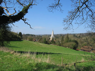
- In 120 metres you come out through a wooden swing gate and bear left along the car road, your direction 290°, past the Church of St James Shere, on your right-hand side (well worth a visit).
- [4] In 100 metres your onward route is to cross over the main road (slightly to the right) in the centre of Shere, with the White Horse pub opposite, and to its left the William Bray pub - both pubs being early lunch options. Continue on Lower Street, with the Tilling Bourne stream on your right, your direction 305°. (But you might like to explore the village a bit first by turning right over the stream into Middle Street, with a tea shop and a forge on your left-hand side, or by turning left, which takes you to the museaum in 140 metres.)
- Continuing on, in 80 metres ignore the Orchard Road turning on the left. Go straight on, past the sign saying "No entry except for access". In 20 metres you pass The Old Prison House on the left.
- In a further 65 metres with Rectory and Summerdown Cottages on your left and a ford and footbridge over the river on your right, carry straight on , through a wooden swing gate, onto a signposted public footpath, your direction 250°, the river still on the right.
- In 90 metres ignore a turning on the right across the river. In 20 metres you come to a wooden swing gate on the right. Go through it to continue ahead, the river still on your right and your direction 250°.
- [5] In 110 metres go through another wooden swing gate (Vicky's Gate) (it has another ford and wooden footbridge on its right).
- [5*] Here you have a choice: the main route, or a longer morning via Albury Park and a lunch pub.
- To do a loop of Albury Park: turn right to cross the footbridge and go up Chantry Lane, and follow the Albury Park Option below.
- To continue on the main walk: turn half left to cross a trail and go through a kissing gate ahead, to enter Albury Park. Keep ahead through the park on a wide grassy path with fences on both sides, gently uphill, your direction 205°.
- In 600 metres exit the park through a wooden swing gate with South Lodge on your right.
- [5A] The Albury Park option rejoins here. Go across the car road (slightly to your left) to continue on an earth car road, soon gently downhill, your direction 170° [6].
- Go straight on for 220 metres, passing several houses on your right-hand side. You will reach a road where you turn right. In 20 metres you come to the William IV pub, Albury Heath, on your right, which was the suggested lunch stop - but it CLOSED suddenly in September 2023 and is up for sale.
- Continue along the road past the closed pub. In 275 metres go under the railway bridge, ignoring footpaths to the right and left, to continue on the car road.
- In 370 metres you come to a car road T-junction and turn left,signposted to Farley Green, your direction due south.
- In 45 metres turn right onto a broad track, signposted as a public footpath (The sign to “Surrey Hacking Park and Ride” was missing November 2021), your direction 215°.
- In 40 metres you pass the horse-riding centre on your right. Continue on uphill and slightly to the right. In a further 50 metres keep straight on across a track (a horse gallops).
- [7] In a further 70 metres where the track bends left go right, following a two-armed footpath sign, along an enclosed path with a fence on your left and hedge on the right, gently uphill, your direction 265°.
- In 250 metres the hedge and tree-line on your right ends. Keep ahead, still gently uphill, and in 40 metres go through a gap between fences, now on a grassy way between fences, heading towards woodland.
- [8] In 110 metres go through a metal swing gate to enter a pine wood, marked Blackheath on the OS map. In 20 metres take the right-hand fork and now keep ahead, ignoring all ways off.
- In 210 metres cross over a stile in a fenceline. In 20 metres at a junction of paths, keep straight on (the footpath post is numbered 235), your direction 285°.
- [!] In a further 160 metres you come to a multiple path junction in a large open area. [!] Imagine this space as a road roundabout and take the second left path (this is not very distinct at first, whilst the third left, within a metre of it, is broader), your direction 245°.
- In 40 metres your way merges with one on your right. Continue on, now on a distinct path, your direction now 205°.
- In 40 metres you come to a T-junction with a wide bridleway, with a blue arrow on a post pointing right. Here you turn right, your direction 280°. Your way now goes straight off into the distance, almost as straight as a Roman road.
- Ignore all ways off through Blackheath Common. The track eventually narrows to a sandy path, which heads uphill, before later broadening and levelling out again. After 1.2 km exit the Common through posts to the left of a metal fieldgate and keep straight on through a car park.
- On the other side of the car park, with some houses on your left, continue ahead on the tarmac road (Blackheath Lane), your direction 255°. In 145 metres you come on your right-hand side to what used to be the Villagers pub, but is now a residential development "Queen Victoria Cottage".
- What used to be the pub's car park currently remains, to the left of the building. Turn into this parking area and almost immediately [!] veer half left by a one-armed bridleway sign to enter a path into woodland, also marked with a low level blue-painted post, your direction 285°.
- In 100 metres take the left fork marked by another blue-painted post, your direction 295°. In a further 80 metres you pass a house on your left.
- [9] In 70 metres cross over a car road, slightly to your right, to continue ahead, following a bridleway sign, your direction still 295°. In 170 metres cross over a path to continue on, still in woodland.
- In 25 metres you come to a T-junction with an unasphalted car lane marked Downs Link and you turn left , your direction 280°. In a further 80 metres you pass Tangley Way, wooden buildings around a courtyard, on your left. You are now on a fenced-in, car-wide sandy track.
- In 120 metres keep straight on at a junction, passing a pair of wooden gates on your left, gently downhill on a path in woodland, your direction 295°.
- In 200 metres your path starts to go downhill more steeply, initially in a cutting. In a further 160 metres the village of Chilworth is visible away to your right. In another 280 metres you pass two open-sided hay barns on your right.
- In 45 metres you come to a T-junction where you continue to the left (virtually straight on), your direction 280°. You can glimpse Great Tangley Manor House through the hedging on your right. In 80 metres you pass the entrance drive of this house.
- 240 metres further along the lane, with a car road T-junction 80 metres ahead, [!] turn right at a three-armed wooden sign saying "Downs Link", your direction 305° (The sign is missing - November 2021) and follow a potentially muddy path through woodland. The path is usually navigable, but if it looks unpromising, continue along the lane for 80 metres down to the car road T-junction, and turn right along the verge and pick up the main directions where the route crosses the road.
- Until the asterisk [*] below, your route is to follow the Downs Link.
- In more detail: Ignoring ways off, in 160 metres cross over a car road to continue on a bridleway marked "Downs Link", your direction 245° initially [10].
- In 20 metres ignore a path to the right to continue on past a house on your left through another potentially muddy zone. In 280 metres you pass a post informing you that the South Downs Way is 305 metres ahead. Continue 20 metres to the path junction.
- At this point you could detour to the Tower - a 1930s folly - and Chinthurst Hill for a good view. See the Chinthurst Hill Tower option below.
- Continuing on the main route, with a two-armed footpath post on your left, turn right on the Downs Link bridleway, your direction 255°
- In 345 metres ignore a stile and footpath off to the right and continue downhill on a left bend with the main path, your direction 200°. Visible ahead of you are the outskirts of Shalford village.
- In 345 metres, amid more potential mud, you pass Southlands with its horses on your left and come down to a car road. Cross it to continue ahead along a tarmac road, Tannery Lane, signposted Downs Link, your direction 225°.
- [10A] The Chinthurst Hill Tower option rejoins here . In 20 metres by a Downs Link post, go up left on a tarmac path towards a pair of houses where you turn right. In 40 metres cross Drodges Close to continue on the tarmac path to the left of the phonebox, parallel to the road below you on the right.
- In 80 metres head down to the left of the bridge and in 20 metres fork right to go over a pedestrian mini-bridge which is below and to the left of the main road bridge.
- [*] You come to a path T-junction. Go right, under the main bridge on a clear path, your direction 330°, with industrial buildings on your right and the River Wey on your left.
- You now keep ahead on this path, with the river down below and to your left, being alert to cyclists coming from behind you at speed - many don't have warning bells these days. In 670 metres go over a bridge crossing the river and keep straight on towards the A281, reaching it in a further 65 metres.
- Here you have a choice
- The Cycle Path route . cross the road and keep ahead on a surfaced path for cyclists and pedestrians (the raised bed of a dismantled railway). In 450 metres cross a new bridge with metal railings over the river and at its far side turn left down steps to the riverbank path below. Turn left to go under the bridge and continue ahead on the path, passing through a metal kissing gate, with the river on your right-hand side. Bear left on this riverbank path as the river bends left and in 390 metres you arrive below the road bridge for the A248. Go through a wooden kissing gate, go up a ramp and cross the road at the start of the bridge on your right, then drop down on the other side, and continue along the riverbank path - on the Main route below.
- The Main route : At the junction with the A281, turn right on the pavement of this A road and in 35 metres cross the bridge over the river. After 80 metres, with Somerswey Cul-de-Sac on your right, cross the road. 10 metres beyond a red brick wall on the left, turn left on a signed path, through a strip of woodland, with the river down below on your left, your direction 310°.
- In 180 metres you emerge from the path with Wharf Cottages at your left. Continue ahead along a tarmac path, your direction 300°.
- In 80 metres continue on a gravel path with an extensive office and industrial estate on your right. In a further 145 metres you come to the A248 and a bridge.
- [11] [**] If you want to end the walk at this point, go right on the A248 to the station at Shalford.
- For the Main route, cross the road go left over the bridge walkway and immediately turn right to pick up the riverbank path on the other side by the National Trust sign, your direction 335°.
- The main and Cycle Path routes continue
- The River Wey is now on your right. Keep straight on along the riverbank, ignoring all ways off, in due course going under a pipe-run bridge next to a railway bridge,then passing St Catherine’s Lock and eventually going under another bridge.
- After 2.5 km of this riverbank walk, the path crosses a mini-weir by a bridge. Immediately turn left with this branch of the river now on your left, your direction 350° [12].
- In 150 metres go over a bridge with metal railings and another mini-weir. Now the canal is on your right and the river on your left.
- In 80 metres you reach Millmead Lock. For tea at the Yvonne Arnaud Theatre, go right over a bridge. In 70 metres you come out to the entrance of the building. After tea, turn right out of the theatre to return to Millmead Lock and go straight on. In 25 metres cross another bridge.
- If not going to tea at the theatre, turn left at Millmead Lock and cross the bridge. The Britannia pub , a tea option, is opposite.
- Turn right with the river now on your right-hand side, your direction 335°.
- In 130 metres fork right off the car road to follow the riverside terrace path. In 75 metres, by the bridge, bear left with the path up beside the White House pub on your left; this is another tea option.
- With St Nicholas Church ahead, turn right , following the pedestrian sign to the station. Continue along the path to go under the bridge, then ahead up a short flight of steps. Turn left at the top, soon reaching the main road where you turn right.
- In 50 metres you come to an underpass which takes you to Guildford Railway Station on the other side of the road for trains back to London.
Albury Park Option (adds 2½ km)
- Start from Gomshall station as normal and follow the main Walk Directions up to point [5*], where there is a second ford and footbridge over the river on the right.
- Instead of turning half-left onto a broad grassy path through parkland, turn right. Cross the river on the footbridge and go up Chantry Lane.
- In 200m, having passed a fine old cottage on the left, turn left onto a signposted footpath going uphill into a wood. In 50m go through a metal kissing gate and continue along the left-hand edge of a field, crossing a private driveway along the way.
- In 225m go through another kissing gate into a wood. In 350m leave the wood through a gate to continue with a wire fence and tall hedge on your left.
- In 125m continue across the grass after the hedge ends, now with a view of the Catholic Apostolic Church ahead on your left. In a further 125m go through a side gate and down a track to a road (the A248).
- Turn left onto a tarmac path beside the main road. In 125m go across a tree-lined driveway leading to the church. In a further 250m the A248 crosses the River Tillingbourne and swings round to the right at a road junction, but you bear left into New Road, passing a cottage on the left.
- Immediately after this cottage turn left through a side gate onto a long straight driveway into Albury Park, part of the Albury Estate. This drive is not shown as a right of way but (as stated) “Access is permitted to the Old Parish Church between 10am and 5pm summer, 3pm winter”.
- In 300m keep left where the driveway forks. In a further 150m (at the next junction) go straight ahead across the grass to come to the unusual old Saxon Church of Ss Peter and Paul, which is well worth a visit.
- After visiting the church retrace your steps towards the junction of driveways and veer left across the grass, aiming for a footpath signpost alongside another driveway 50m away. Cross this driveway and (as indicated) go up a grassy path to a wooden kissing gate in the trees ahead.
- Go through the gate and follow the waymarked footpath through these private woods for nearly 1 km. Initially you go quite steeply uphill, bearing left where another path merges from the right. Go straight on at all other path crossings. The path eventually levels off and starts to go gently downhill on a long straight stretch, your direction 140°. After briefly going alongside a wire fence the path veers left and right to join an avenue of magnificent old sweet chestnuts.
- Leave Albury Park through a metal fieldgate and go along a short track past a cottage. Go through another fieldgate to come out onto a road, rejoining the standard walk which comes up from a footpath on the left. Resume the main Walk Directions at [5A]
Chinthurst Hill Tower Option (adds 0.6 km)
- Go straight ahead at the path junction, climbing gently. In 150m the path forks at the bottom of a steeper slope; you can take either route as they soon rejoin (the right-hand path, with steps, may be easier).
- In a further 150m turn right onto a broad grassy path at a T-junction, still climbing. In 50m turn left to resume the climb towards the summit.
- In 50m go straight across another broad grassy path to reach the Tower (a 1930s folly) at the top of Chinthurst Hill, with fine views ahead towards the South Downs.
- You can return to the standard walk route by simply retracing your steps, but the following alternative is shorter:
- Take a clear path through the bracken to the west of the Tower. After recrossing the broad grassy path you go steadily downhill, your direction 290°.
- In 150m the path merges with another path from the left and comes to a new wooden gate. Go through this and downhill to an open area, meeting a tarmac driveway at a hairpin bend.
- This driveway now takes you all the way downhill, although to cut off a corner at this bend you can go across it onto a grassy path, meeting the drive again about 50m further down.
- In 300m the driveway swings right to meet a lane where you turn sharp right, almost doubling back (a notice here indicates that although this drive is private, pedestrian access is permitted).
- Go along the lane, your direction 310°. In 400m the standard walk route rejoins from a bridleway on the right and you turn left into Tannery Lane. Resume the main Walk Directions from point [10A].