Sunningdale to Windsor walk
Virginia Water, Windsor Great Park, the Long Walk, and Windsor Castle

Windsor Castle
england castle unitedkingdom britain book1 windsor windsorcastle southeastengland walk18 swcwalks 3067689997
CIMG8071
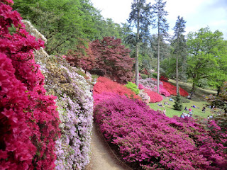
Kurume azaleas in the Punchbowl, Valley Gardens
May-15 • Sean O'Neill
book1, swcwalks, walk18 6147544841827911634 P

Bridge over stream, Valley & Heather Gardens
Aug-13 • magyardave2002 on Flickr
book1 walk18 swcwalks 9642303001

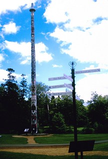
Totem
Canadian Totem Pole Windsor Great Park. D.Allen Vivitar 5199 5mp
Jun-07 • magyardave2002 on Flickr
park totem book1 walk18 swcwalks 577455936
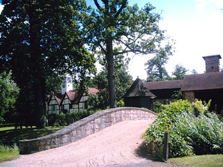
Belvedere
Clock tower by bridge at Belvedere (now AHMIBAH) Farm by Coworth Park. D.Allen vivitar 5199 5mp
Jun-07 • magyardave2002 on Flickr
book1 walk18 swcwalks 610325104
Windsor Great Park
| Length | 17.0km (10.6 miles), if ending the walk at Windsor Riverside railway station: 16.6 km (10.3 miles) if ending at Windsor Central, and 16.8 km (10.4 miles) if ending at Staines. Allow 4 hours for the walk. For the whole outing, including trains, sights and meals, allow 8 hours – or 9 hours if visiting Savill Gardens. |
|---|---|
| Toughness | 2 out of 10. |
| OS Maps | Explorer 160 or Landranger 175 (nearly all the route is on 176 too). Sunningdale, map reference SU 953 667, is in Surrey, 15km south-west of Heathrow Airport. Windsor is in Berkshire. |
| Features |
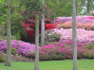
This walk explores Virginia Water (a lake), Valley Gardens (which overlooks it), Windsor Great Park (a forest and deer park), and the Long Walk to Windsor Castle. Near the start of this walk, you go through Coworth Park, with its polo playing fields, to enter the 4,800 acres of Windsor Great Park (no entrance charge), near the Virginia Water lake. You pass through Valley Gardens, overlooking the lake, which have a vast collection of rhododendrons and azaleas, which flower spectacularly in early May. Check @WindsorGtPk Lunch is in a pleasant, spacious cafeteria overlooking the Savill Gardens (you have to pay to enter the gardens). After lunch, the route is up Rhododendron Ride to Cow Pond, which is covered in an array of water lilies. From here, it is through some light woods and on to the Royal Lodge, to pass through gates into Windsor Deer Park. You now have a choice of route onwards: make for the Copper Horse statue and simply embark on the full 4km of the Long Walk (which feels a bit long after a while), or follow the original (and more complicated) route through the park, joining the Long Walk 1km further along. When you eventually reach the gates of Windsor Castle you turn left into the town, to walk through some of its oldest streets and their many inns, cafes and restaurants are all suitable for a tea stop. This walk may be undertaken all year round and it is relatively mud-free in winter. However, the best time to try it is in early May, when the azaleas are in full bloom, and the rhododendrons are coming into flower.
|
| Walk Options |
Alternative ending via Runnymede and Thames Path to Staines This alternative afternoon route diverts through fields and along quiet lanes and tracks to the historical Magna Carta site at Runnymede Meadows (Wikipedia, National Trust ) where there are several memorials. It then follows the Thames Path to Staines. It starts from the suggested lunchtime stop at the Savill Garden Restaurant, and offers an alternative lunch stop nearby for those preferring a pub lunch. It does not visit the smaller site on the east bank of the Thames (also NT: Magna Carta Island and the Ankerwycke Yew), as there is no nearby bridge, and no towpath on the opposite bank. [May-19] There is plan to create a pedestrian ferry crossing here. Shorten the walk You can phone for a taxi at lunchtime from the Savill Gardens cafeteria, to take you to Windsor. |
| Windsor Great Park |
Windsor Great Park is managed by the Crown Estate. Much of it is private. The public area are:
There are several expensive car parks (£12 a day). Limited free parking on the A30 - get there early! Map (pdf) |
| History |
Sunningdale Parish Church was built in 1840 at a cost of a mere £1,600. The 100 foot high Totem Pole in Windsor Great Park was a gift to the Queen in 1958 from British Columbia, and is made from a 600 year-old western red cedar tree. The giant Obelisk in the park was put up by King George II to commemorate ‘the success in arms of his son, William’. Savill Gardens (tel 01753 860 222) are named in honour of Eric Savill who, with encouragement from King George V, created the gardens on inauspicious, fast-draining sandy soil. Later, in 1947, Eric Savill began work on Valley Gardens, created on the site of an old gravel pit. The Copper Horse in the park is a huge equestrian statue to King George III which was commissioned by his son, George IV. A Castle was first built at Windsor by William the Conqueror in 1070. Windsor Castle fell to a siege by John, King Richard I’s brother, in 1193, and was captured, without a defence being mounted, by the Parliamentarians in 1642, the first year of the Civil War. It suffered badly in the fire of 1992, Queen Elizabeth II’s ‘annus horribilis’. Windsor Castle (tel 01753 831 118) is open Thursday to Monday (closed Tuesday and Wednesday): March to October from 10am to 5.15pm, November to February from 9.45am to 4.15pm (last admission one hour earlier, both periods). Check before visiting as the Castle is closed on a number of days during the year. Admission (2023) is £28 in advance, and £ 30 on the day. Note: entrance is free to residents of the Royal Borough of Windsor. |
| Travel |
Take the train nearest to 9.50am from Waterloo Station to Sunningdale. Journey time 47 minutes. Trains back from Windsor &Eton Riverside Station to Waterloo run twice an hour. Journey time 58 minutes. You can also return to London from Windsor Central Station to Paddington, changing at Slough. This service is also half-hourly, with a shorter journey time of around 32 minutes. Buy a day return to Windsor &Eton Riverside Station, plus a single from Staines to Sunningdale. If you intend to return to London from Windsor Central station, you will need to buy separate singles for the two legs of your journey today. If you are ending your walk in Staines, then a day return to Sunningdale should suffice. |
| Lunch |
The only lunchtime stop on the main walk is the Savill Garden Restaurant (tel 01784 432 326) in the Savill Building, some 7.8 km into the walk. Operated by Benugo, this is a spacious, comfortable cafeteria with a selection of light meals and hot dishes, with roasts on a Sundauy. The cafeteria is open from 9am to 5pm, seven days a week (2023) with lunch served from 12 Noon until 4.30pm. You don't have to pay to enter Savill Gardens to use it. Sharing the Savill Building with the cafeteria is a large gift shop - well worth browsing through. If you are taking the alternative afternoon walk to Staines, it is suggested you stop first for lunch at the Savill Garden Restaurant. The original pub stop on this route, The Sun Inn, in Englefield Green, closed in 2018 and remains permanently closed as of 2023. However, there is another pub in Englefield Green, The Bailiwick (tel 017894-682888), a free house, open Wednesday to Sunday (2023) serving light meals and snacks at lunchtime, Wednesday to Saturday, and classic roasts on Sunday, from 12 noon until 3pm. This pub is located by the Cheeseman's Gate pedestrian access to Windsor Great Park. |
| Tea |
There are plenty of pubs and tea shops in Windsor to choose from for a post-walk tea stop. If the weather is fine, one suggested venue is The Boatman (tel 01753 620 010), a gastropub and riverside restaurant located directly behind Windsor &Eton Riverside railway station. Per Trip Advisor, this pub is proud to be the only proper pub on the Thames (in Windsor) with uninterrupted views of the river overlooking Eton bridge. For those who prefer tea or coffee at walk-end, a suggested venue is The Cinnamon Cafe (01753 857 879) in the Windsor Royal Station retail precinct (site of former railway station terminus). |
| Updates | No major changes. This edition following Book check and walk update - May 2023. Opening times and admissions uodated May 2023. |
| Book |
This walk was originally published in Time Out Country Walks near London volume 1. We now recommend using this online version as the book is dated. The book contained 53 walks, 1 for every week of the year and 1 to spare. Here is our suggested schedule |
|---|---|
| Profile | |
| Help Us! |
After the walk, please leave a comment, it really helps. Thanks! You can also upload photos to the SWC Group on Flickr (upload your photos) and videos to Youtube. This walk's tags are: |
| By Train |
Out (not a train station) Back (not a train station) |
| By Car |
Start SL5 0EL Map Directions Return to the start: Finish SL4 1QG Map Directions Travel to the start: |
| Amazon | |
| Help |
National Rail: 03457 48 49 50 • Traveline (bus times): 0871 200 22 33 (12p/min) • TFL (London) : 0343 222 1234 |
| Version |
May-23 Marcus |
| Copyright | © Saturday Walkers Club. All Rights Reserved. No commercial use. No copying. No derivatives. Free with attribution for one time non-commercial use only. www.walkingclub.org.uk/site/license.shtml |


Walk Directions
- [1] Coming out of Sunningdale Railway Station from Platform 2, exit the station by the ticket office and turn left , your direction 125°. In 45 metres turn left again to go over the railway crossing. At the other side of the crossing, turn left on a tarmac path parallel to the railway lines, back past the station building on your left-hand side and past new houses on your right.
- In 60 metres the tarmac ends and you keep ahead on an earth path, still parallel to the railway lines on your left and soon gently downhill. In 150 metres ignore a path to your right into the recreation ground. In a further 135 metres you cross a bridge over a stream and turn right to drop down alongside the stream, which is now on your right-hand side, with a playground and tennis court (Broomhall Lane Recreation Ground) coming up shortly on your left-hand side.
- Ignore a footbridge to your right and after 180 metres you come out through a metal barrier to the B383 road, where you turn left . In 100 metres turn right on to Station Road.
- In 200 metres, and with Holy Trinity Church of England Primary School on your right-hand side, turn right on Church Road. You pass the entrance to the school on your right and after 250 metres you come to the entrance of Holy Trinity Sunningdale Church on your left (worth a look inside). 100 metres beyond the church you turn half-left up Whitmore Lane (not the sharp left fork, High Street).
- In 320 metres ignore a byway sign to the left beside Sunningdale Bowling Club. In a further 200 metres you pass the entrance to Callaly House on your left-hand side and then have Tittenhurst Park behind the wall on your left (the park is not yet visible).
- In a further 190 metres, just after the road bends to the left, [2][!] take the signposted footpath to the right, through a wooden swing gate (with a wooden fieldgate to its left) and, in 20 metres, cross a bridge over a stream to go straight on, your direction 110°.
- In 60 metres, as the wood ends, you enter Coworth Park. Cross a gravel track and continue ahead on a grassy way with a wooden fence on your right and a ditch on your left. In 450 metres, with a timber-framed building with a clock tower ahead to your left and the renovated Belvedere Farm ahead to your right, you turn left, just before the bridge, on a tarmac car-wide bridleway, your direction 10°.
- You pass a lake on your right and then the polo fields of Coworth Park Guard's Polo Club on your left, in 450 metres coming out on to the A329 road. Turn left down this road. In 150 metres turn right into the entrance of Virginia Water South car park (formerly Blacknest car park). In 20 metres go through and under car park barriers and bear left with the road and in 30 metres pass a timber, round kiosk building, with car park paying machines. Now keep ahead, with park information boards to your left, down a broad, gravel track, with woodland on either side, your direction 50°. You are now in Windsor Great Park.
- In 200 metres you come down to Virginia Water Lake, where you turn left, onto a tarmac path, your direction due west, with the Lake on your right-hand side.
- In 250 metres go over a small brick bridge with stone parapet walls and bordered with large rocks. Bear right with the path at the end of the bridge [3]. There is a refreshment kiosk on your left, serving tea and coffee. Now either keep ahead on the surfaced path or - if directed by signage - take the sandy path to its right, and keep ahead with the water over to your right, your direction now 20°, gently uphill.
- In 210 metres cross the lake by a large five-arch bridge with stone parapets. 5 metres beyond the bridge [!] drop down from the path and turn right onto a faint path, to go back along the lakeside to your right, on a meandering path initially through light woodland, with tree route footbed, latterly through a more open area, your direction 125°.
- In 270 metres the path bears half-left over grass to come to the top corner of the fence to Flinders cottage. Here turn right along the front of this cottage, your direction 45°. In 80 metres, veer left at Lakeside Cottage, onto a tarmac path. Then in 15 metres fork right over grass, your bearing 40°.
- In 100 metres you cross a drive with a Crown Estate, Private entrance gateway over to your right and keep ahead on a grassy way, on at times an unclear path, with the fringe of the wood on your right-hand side, going due north. 80 metres beyond this gateway, where the wood fringe goes sharply right, you can see the wooden railing on the tarmac lane by the lakes. Head towards this lane, across grass, on a bearing of 40°. In 160 metres join the lane as it swings right, between the upper and lower lakes.
- Once on the other side of the lakes [4] as the lane swings to the left, turn right, then left, your direction 115°, to go uphill on a gravel path signposted Valley and Savill Gardens.
- [!] Route following is relatively complex in Valley Gardens [!] . Should you be unable to follow the directions suggested below – or if you inadvertently go off piste – simply wander round the gardens to your heart’s content, then head down to the lake and turn left, which will take you in due course to the Totem Pole, where you rejoin the directions.
- 70 metres past the entrance signs to the gardens, take a left fork, uphill, on a gravel path, your direction 100°.
- In 20 metres ignore the turn downhill to your right and continue uphill, as the path swings left. In 90 metres near the top, as the path levels out, first ignore a path down to the right (by post no.HH 28) but then in 30 metres you come to a post on your left with red and yellow bands at its top. Here [!] turn right downhill on a grassy, car-wide track, your direction 175°.
- In 5 metres you pass a wooden bench over to your left. In a further 20 metres [!] you fork left uphill on a grass track, on a bearing of 155°.
- In 40 metres bear right, merging with a car-wide grassy track, to go downhill, due south. In 45 metres, and 30 metres before a sandy lane T-junction below [!] turn left on a grassy car-wide track, your direction 85°.
- Carry straight on, ignoring other ways off. In 110 metres ignore a grassy car-wide fork going up steps on your left (by post no.53) and keep on, now downhill, on a bearing of 80°.
- In 25 metres, as you come out into the open, [!] bear half-right from the oak tree and a bench, downhill, your direction 140°, to cross a gravel path then head for a wooden bridge. In 80 metres go down steps to cross the bridge, go up steps on the other side and then keep ahead, uphill, your direction now 110°.
- Keep on uphill across the open grass of Azalea Valley, between a near bench to your right and a far bench to your left.[!] Once the left-hand bench is facing you, 30 metres over to your left, go half-right onto a car-wide earth path, gently uphill, on a bearing of 145°.
- In 60 metres, by a post with a yellow band on its top, you cross a path, to continue straight on. In 30 metres at another path crossing, keep ahead (slightly left) now gently downhill as the path swings to the left. The lake is now visible through the trees below on your right-hand side, and your path onwards will be roughly parallel to its edge.
- In 100 metres you come down into a green valley, Valley Garden, with the Plunkett Memorial (a little pavilion with four columns) some 250 metres away to your left at the top of the valley.
- Cross the valley bottom to go up the other side on railway sleeper steps, your direction east. At the top of these steps keep straight on (slightly right) . Then in 20 metres at a T-junction, go left onto a grassy path, your direction 350°.
- In 15 metres ignore a fork downhill to the right and in a further 60 metres ignore forks downhill to the left then right. Your path is now a gravelled car-wide track.
- In 90 metres you come to a three-way junction, all car-wide tracks. [!] Go sharp right, on the rightmost (gravel) one, your direction 130°, to head gently downhill as the path swings left. In 45 metres you pass a bench on your left-hand side and in a further 30 metres another bench, with the lovely grassy valley of the Punch Bowl falling away to your right. 55 metres past the second bench ignore a fork off to the right and keep ahead on the car-wide earth track.
- In 40 metres cross a car-wide earth road by the large stump of what was a giant Wellingtonia tree (cut down sadly due to disease, 2021) to keep straight on. 15 metres beyond this tree stump you come to a car-wide earth road where you turn right, on a bearing of 95°. In a further 25 metres ignore a fork to the left, to keep ahead, gently downhill.
- In 400 metres you come right up to the Totem Pole [5]. Note: 2023 - the surround around the Totem Pole is fenced off to enble the grass to recover. Unfortunately, this stops you from reading all about this monument. Until the Totem Pole reopens, turn left in front of the Totem Pole and bear half-right over grass, in a northerly direction. In 50 metres you drop down to cross a stream on a four-plank bridge into light woodland with the lake on your right-hand side.
- In 110 metres do not go over the bridge with white railings on your right-hand side but instead cross a path and go straight on, your direction 10°, through a lightly wooded area. In 115 metres you come out onto a tarmac road (where to the right is signposted “Vehicle Exit”) where you turn left , gently uphill, in the direction of a sign for Valley Gardens.
- In 160 metres at a path crossing, and 80 metres before fingerpost signs ahead, [!] turn right onto a gravel and earth car-wide track, soon between rhododendron bushes, your direction north. In 300 metres your path crosses a stream and starts to ascend. In a further 120 metres, near the top, go left, to come out in 35 metres at Obelisk Pond. Here you turn right, onto a tarmac car-wide path.
- In 200 metres fork left and in 40 metres you come to the Obelisk. To continue on, return to the tarmac path and by a sign to ‘Savill Garden and Shop’, you follow this sign’s direction along the tarmac path, in 200 metres coming to the entrance on your left to Savill Gardens and the Savill Garden Restaurant, the suggested lunchtime stop.
- The Alternative ending via Runnymede and Thames Path to Staines option starts here. See below.
- After lunch, return to the tarmac path and turn left, to continue in the same direction as before (when approaching the restaurant), on a bearing of 15°. In 70 metres ignore a turn to the right.
- In 225 metres, as the path swings left past double storey greenhouses, take the gravel, car-wide track ahead ,Rhododendron Drive, past a sign saying ‘No Cycling’.
- In 360 metres cross a stream on a bridge with brick headwalls. In a further 40 metres [6] at a crossing of paths, turn left, due west, to Cow Pond with its water lilies. Carry on around the pond, still keeping it on your right-hand side. Where the gravel track swings to the left, keep ahead, now on grass, your bearing 340°. At the far end of the pond, when the wide green path comes to an end, turn left over the stream on a wooden bridge with wooden handrails and continue ahead through light woodland, your direction 300°.
- Follow the indistinct, meandering path through the trees in this lightly wooded area, heading in the direction of the car road soon visible ahead, and keeping the bogs and marshes over on your right-hand side. In 120 metres you exit the wood and turn right immediately, to keep the fringe of the wood to your right, your direction due north.
- The path swings right and in 100 metres you cross a car-wide horse ride covered with sand. Now bear right, your direction 50° onto an earth way parallel to the horse ride 20 metres over to your right, and with a ditch on your right-hand side. Keep ahead on this earthen path, crossing wooden bridges, and ignore all ways off. In some 290 metres with the pink gatehouses of the Royal Lodge in view over to your left, leave the earthen path and bear left over grass and head towards this gatehouse.
- When you reach the tarmac estate road in front of the lodge turn right on it [7] and go straight on (soon slightly left) – the road is clearly marked "Deer park. No commercial vehicles".
- In 85 metres you go through the gates to the Deer Park. Keep ahead on the tarmac estate road. In 55 metres there is a fork to the right.
- For the simpler onward route (The Copper Horse route) ignore the path on your right and keep ahead on this estate road, in 600 metres crossing a stone bridge. Just beyond this, bear left up a grass slope to reach the Copper Horse statue. Now simply head downhill and follow the Long Walk north to Windsor Castle, joining the main route at [8A] below.
- For the original Book route, which can be challenging to follow, fork right off the estate road, your direction 320°, on a narrow but fairly well used footpath.
- Keep straight on along this undulating path. In 140 metres go right on a path which starts grassy but soon becomes sand and earth, gently downhill towards trees, your direction 40°.
- In 200 metres after entering the lightly wooded area you come to a very wide, gravel and sandy avenue for horses. Turn right on this avenue, your direction 85°.
- Keep ahead along this horse ride. In 240 metres a track joins from the left. In a further 80 metres, at a major crossing of tracks, cross over and keep ahead (slightly to the left) along the sandy, car-wide bridleway, your direction 35°.
- Stay on this sandy bridleway for the next 450 metres. Now look out for two oak trees on your left-hand side, numbered 880 and 881. [!] You now turn left off the bridleway [!] and walk between the two trees, ignoring the more obvious path to the left of tree number 880.
- But if you miss this turning, which is easy to do, simply keep ahead until you reach the end of the sandy bridleway. Now turn left, to pass Bear's Rails pond on your left, and keep ahead, in a general westerly direction, and eventually you will come to the Long Walk, which you join, to turn right along it.
- If you found the turning, walk ahead on a compass bearing of 260° (half-right from the sandy bridleway), through brush and trees, with no obvious path to start with, but you soon pick up a clear, narrow path.
- In 100 metres, with the remains of two tree stumps on your left, and some 40 metres before the wood’s valley and stream below, veer right with the path, your direction now 310°.
- In 140 metres turn left off the path to cross a ditch where it goes through a concrete pipe under your path. On the far side, turn right with the path and head uphill, your direction 320°.
- In 130 metres exit the wood and turn right on a car-wide track, your direction 25°. In 160 metres your track joins an access track and you keep ahead. In 60 metres you pass the entrance driveway to scout huts on your left-hand side.
- In 70 metres you cross a stream and 5 metres beyond it [8], fork left, in 75 metres coming to a notice board for Bear’s Rails Pond on your left. A track joins from the right and you keep ahead along it.
- In 85 metres go through deer protection gates and carry on, along the hedge then fence to your right, avoiding muddy areas as best you can.
- In 300 metres you have a fine view of the Copper Horse on the hillock away to the left and you follow the bend of the fence to the right, your direction 310°.
- In 100 metres or so you can see Windsor Castle ahead of you. Now head towards the tarmac path ahead of you, the Long Walk, and in about 180 metres you turn right onto (or alongside) it.
- [8A] Continue to head north on the Long Walk. In about 1km you exit the park by passing though the swing gate to the left of white double gates, with Double Gates Lodge on your right.
- In 750 metres you cross the main road, the A308 [9] and continue on the Long Walk (with the unwelcome din of planes overhead as they come in to land at Heathrow Airport).
- In 1.1km you reach a set of gates to Windsor Castle. Here you turn left to exit Windsor Great Park through side gates on to Park Street, passing the Two Brewers pub on your right-hand side. In 85 metres fork right uphill on St Alban’s Street, keeping the castle walls on your right-hand side.
- In 90 metres you pass the Parish Church of St John the Baptist on your left-hand side. In a further 25 metres you pass Church Lane to your left, and then in 50 metres, turn left and walk 10 metres to be by the Henry VII gatehouse entrance to Windsor Castle.
- Turn left, exactly opposite the gatehouse, to go down Church Street, coming in a few metres to the Carpenters Arms pub. Continue to the end of the street, with Maloney’s Irish Bar directly ahead. Here turn right down Church Lane.
- At the end of Church Lane turn right, by the Three Tuns pub, down the passageway beside Market Street, passing the Guildhall on your left-hand side. In 25 metres, by the old leaning Market House, turn left on Queen Charlotte Street, supposedly the shortest street in Britain.
- Turn right in the High Street (signposted to Central Station and Riverside Station). In 35 metres you pass Queen Victoria’s statue, to keep straight on. In a further 60 metres, you come to the approach road on your left-hand side to Windsor Central Station (for trains to Paddington, changing at Slough). For Riverside Station, keep straight on along the High Street, in 75 metres passing the King & Castle Wetherspoon’s Freehouse on your left-hand side.
- In 75 metres ignore River Street to the left to keep on with the castle walls on your right-hand side. 30 metres on, you pass the Theatre Royal Windsor on your left-hand side. In a further 60 metres you pass the statue to Christian Victor, Queen Victoria’s grandson.
- In 40 metres, cross straight over the main road (Datchet Road) onto Thames Street, with the Bel & The Dragon pub on your right-hand side. In a further 40 metres you pass Sir Christopher Wren’s House on your left-hand side.
- In 30 metres, just before the bridge over the River Thames, go down steps on the right-hand side, to follow the riverside walk, along the Thames on your left-hand side.
- In 40 metres turn right by a modern building marked ‘Thameside’, up Farm Yard, which leads in 80 metres to the entrance to The Old Ticket Hall Restaurant, and then to Windsor & Eton Riverside Station (for trains to Waterloo). Immediately behind the station, and facing the river, is The Boatman gastropub, a suggested tea stop.
Alternative ending via Runnymede and Thames Path to Staines
- Continue on the tarmac path past the Savill Building (or turn left onto the path if you have stopped for lunch at the Savill Garden Restaurant).
- In 70 metres turn right through a gap into the Savill Gardens coach park and exit past the vehicle barrier onto a road, where you turn left .
- Proceed with care along the road, which has no pavement, for 650 metres to reach The Sun Inn, closed July 2018 and previously your alternative lunchtime stop. There are no signs of the pub re-opening - it looks permanently closed (May 2023).
- Just past the pub, ignore Kings Lane to the right, and turn right up Prospect Lane, an unmade road. At its end, continue straight on through a wooden kissing-gate onto a footpath between hedges.
- In 300 metres go through another kissing-gate and where the footpath bends right, turn left through a third kissing-gate into a field. Here the OS map shows a wood immediately on the left, but this no longer exists.
- Go across the middle of the field, where there is no clear path, aiming slightly to the left of a white turreted building visible in the middle distance above the trees.
- At the far side of the field, go through a wooden kissing-gate beside a green metal gate and turn sharp right through another kissing-gate onto a car-wide track.
- In 350 metres go through a kissing-gate to continue on the track which soon becomes a tarmac lane (Ham Lane), arriving at a road junction in 250 metres. Just before the junction, over large entrance gates to the right, you can glimpse the striking white turreted and castellated building that you saw earlier. This is the large Grade II listed 18th century mansion, Castle Hill, which is in private ownership.
- At the junction with Bishopsgate Road, go straight across into Castle Hill Road. In 300 metres you come to a main road, the A328.
- Here you could take a no.71 bus to Windsor (bus stop to the left) or to Staines (bus stop across the road to the right). Buses run half-hourly Mon-Sat and hourly on Sunday.
- Turn left along the pavement of the A328, and in 180 metres turn right through a white gate onto a driveway, following a public footpath sign downhill, passing a rather neglected campus of Brunel University to the right.
- At the end of the drive, continue straight ahead on a footpath into woodland, entering the National Trust’s Runnymede site. The path descends and emerges into the open at the John F Kennedy Memorial , situated on an acre of ground given by the UK to the USA to commemorate the assassinated US president.
- Descend uneven cobbled steps to reach Runnymede Meadows where there is an information board about the memorial. Turn right for 150 metres along the edge of woodland to reach The Magna Carta Memorial , erected “to commemorate Magna Carta as a symbol of freedom under law.”
- Cross the meadows below the memorial, and then the main road (A308) to reach the banks of the Thames. Across the river is Magna Carta Island, where the charter is reputed to have been sealed by King John in 1215.
- Currently, there is no suitable way to cross the river to Magna Carta Island, and no towpath on the opposite bank. There is a plan to create a pedestrian ferry crossing here to unite the 2 NT properties.
- Here you can follow the Thames Path for about 3.5km either left, to Windsor, or right, to Staines.
- The path towards Staines soon follows the bank of the river around the edge of Runnymede Pleasure Ground, and later passes a lock and weir before going under the M25.
- At the first bridge you come to, follow the Thames Path sign to cross the bridge into Staines and then resume the riverside path on the other side. Leave the path just before it passes under a railway bridge and join a main road which diverges from the river at this point.
- In 200 metres turn left up Gresham Road to reach Staines Railway Station in 600 metres.