Hever to Leigh walk
2 castles, a stately home, rivers, ponds, woods, undulating hills and three lovely villages


A Kent castles walk
| Length | 14.33km (8.9 miles), 3 hours 40 minutes. For the whole outing, including trains, sights and meals, allow at least 8 hours 30 minutes. |
|---|---|
| Toughness | 2 out of 10. |
| OS Maps | Explorer 147 or Landranger 188. Hever, map reference TQ 465 445, is in Kent, 3km south-east of Edenbridge. |
| Features |
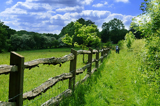
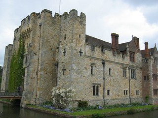
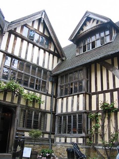
This is a fascinating and very beautiful walk through the Garden of England. It includes two castles, a stately home, rivers, ponds, woods, undulating hills and three lovely villages: the National Trust village of Chiddingstone; Penshurst, with its half-timbered houses; and Leigh (pronounced 'Lie'), with its large cricket green, dominated by the Church of St Mary. The Medway Valley is prone to flooding, and it is possible that parts of this walk may not be passable in extreme conditions. Also, in winter, some bridleways and fields tend to be muddy. There are 3 places to visit on this walk (not to mention the churches), Hever Castle (large, restored, the Boleyn family and Henry VIII connections, Italinate gardens), Chiddingstone Castle (smaller, eclectic art collection, nice tea room) and Penshurst Castle (large manor house). However, you would need to do the walk in mid summer to have enough time to do them justice. Both Hever Castle and Chiddingstone Castle are members of the Historic House Association, which has a recipricol annual membership scheme, a bit like the NT's. |
| Walk Options |
You can shorten the walk by 1.5km by not heading into Chiddingstone when you reach Hill Hoath (see the asterisk [*] in the Walk Directions). This misses out the lunch stop in this pretty village, but you could stop further on in Penshurst and choose between a late pub lunch or tea in the village or in Penshurst Place. If you want to abandon the walk after lunch in Chiddingstone, and you have the OS map, you could head across country to Penshurst Station, one stop to the west of Leigh (but it is not worth doing this after tea in Penshurst because it is almost as far away as Leigh Station). You can extend the walk by just over 2.5 miles by finishing the walk in Tonbridge. You reverse the opening leg of SWC 235 - Tonbridge to Penshurst walk, via Haysden Country Park. |
| History |
Hever Castle (HHA Member, tel 01732 865 224) was erected in 1453 by Sir Geoffrey Boleyn, Lord Mayor of London, and was the childhood home of Anne Boleyn (mother of Elizabeth I). She was courted here by Henry VIII. William Waldorf Astor acquired the estate in 1903, and set about restoring the castle. He employed 1,500 men for five years to divert the course of the River Eden and form a large new lake of 35 acres. He also built a new but surprisingly convincing Tudor-style village on the north side of the castle to accommodate guests and staff. The castle makes the most of its Henry VIII connection. The compact grounds include a maze, topiary and Italinate gardens leading down to the lake, draped on ruins imported from Italy. There is a cafeteria restaurant by the lake. Opening times vary with the seasons; check in advance, but as a general guide: the castle is open Wednesday to Sunday from 12 noon until 3.30 pm, and the grounds and gardens from 10.30 am until 4.30 pm (last entry 3.pm). Admission (From June 2024) is (pre-purchase on-line) £23.35 for the castle, grounds and gardens or £18.35 for the grounds and gardens only, and tickets purchased on entry: £ 25.95 and £ 20.40: concessions, senior tickets and family tickets also avalable, on-line or on entry. St Peter's Church in Hever is a part-Norman church with a fourteenth-century tower topped with a shingle spire. Within the Bullen Chapel is the brass over the tomb of Sir Thomas Bullen, Anne Boleyn's father, showing Sir Thomas in his garter robes. Chiddingstone Castle (HHA Member, tel 01892 870 347) is not much of a castle compared with Hever – it is more of a country squire's house, masquerading as a fantasy castle. It is infact a castellated manor house rebuilt in the 19thC, containing an unusual collection of art and curiosities left behind by its late owner, Denys Eyre Bower. The grounds are open all year round for which you are asked to donate £ 3 in the honesty box for access to the grounds. The castle cum manor house is open from May to October on Sundays, Mondays and Tuesdays from 11 am to 5 pm. Admission for 2024 is £ 11.00. The venue has a pleasant courtyard tea room - open on Sundays and Mondays, when the house is open. The village of Chiddingstone became wealthy as a centre of the iron industry in the sixteenth and seventeenth centuries. The Streatfeild family sold the village to the National Trust in 1939, as a consequence of which it remains largely unspoilt. The building that is now a village shop (with tearoom in buildings at the back) was bought, in 1517, by Anne Boleyn's father as the manor house of Chiddingstone. In 1624, St Mary's Church in Chiddingstone was struck by lightning and extensively damaged by fire. Prominently displayed in the church is a Vinegar Bible of 1717, so called because in St Luke's Gospel, Chapter 20, 'The parable of the vineyard' is misprinted as 'The parable of the vinegar'! The gazebo in the churchyard covers the vault of the Streatfeild family. The stately home of Penshurst Place (tel 01892 870 307) is a perfectly preserved, unfortified manor house, which has been the home of the Sidney family since 1552, when Edward VI gave it to his old tutor, Sir William Sidney. The poet Sir Philip Sidney was born here in 1554. The oldest part of the building dates from the fourteenth century, but the present house represents a curious blend of five centuries of architectural styles. The house, grounds and gardens are open to visitors daily from late March to the end of October and the grounds and gardens at weekends only from mid-February to late March. Admission (2024) is £15.00 for the house, gardens and grounds or £13.00 for the gardens and grounds only. Concessionms and family tickets also available. On the south side of St John the Baptist Church, Penshurst, are timber-framed cottages which form part of Leicester Square (named after a favourite of Elizabeth I) and include a post office house dated 1850. In the Sidney Chapel of the church are many memorials and the effigy of the top half of Stephen de Penshurst, Warden of the Cinque Ports and Constable of Dover Castle, who died in 1299. The fine armorial ceiling in the chapel was restored in 1966. By the side altar is the Luke Tapestry (in Greek), made by Penshurst's former village doctor: it honours the partnership between medical science and Christianity. |
| Travel |
Take the train nearest to 10.20am from London Bridge Station to Hever. Journey time 41 minutes. On Sundays there is no direct service from London stations to Hever; you will need to travel from Victoria or London Bridge and change at East Croydon and/or Oxted, with a longer journey time. Returning from Leigh, you can either take a westbound train via Edenbridge and Redhill to London Bridge (on Sundays you might need to change at Redhill), or an eastbound train and change at Tonbridge for Charing Cross. The journey time for both routes is about 1 hour. It is usually best to take the first train to arrive, so check the timetable when you arrive in order to decide on the right platform. Buy a day return Any Route Permitted to Leigh (Kent). You will need the Any Route Permitted option for your ticket to be valid for both return routes, via Redhill or Tonbridge, but on the way out it is only valid as far as Edenbridge Town (on a different line, but tickets via the two Edenbridge stations are interchangeable). In practice a Leigh ticket is usually accepted to Hever, the next stop, but you might be asked to pay a small supplement. This walk is not very convenient for car drivers, but you could park somewhere in Edenbridge between its two stations and travel out from Edenbridge Town Station and return to Edenbridge Station. |
| Lunch |
The suggested lunchtime stop is the Castle Inn (tel 01892 870 371) in Chiddingstone, some 5.2 km (just over a third of the way) into the walk. This early fifteenth century pub re-opened in April 2017 under new tenants after an extensive, sympathetic refurbishment of the interior. 2024 - the pub is open from Tuesday to Sunday (closed Monday): lunch is served Tuesday to Saturday from 12 noon until 3.30 pm, and on Sunday from 12 noon until 5 pm. Booking ahead also advisable, particularly on a Sunday, when classic roasts are served. The pub also has a pleasant garden for outdoor dining in summer. If you arrive at the pub before 12 noon and plan to dine here, you should be able to find things to do in Chiddingstone to kill time before opening. An alternative stop in Chiddingstone is The Tulip Tree Tearooms in Burghesh Court behind Chiddingstone Stores. Open Monday to Thursday, and at weekends 10.00 am to 5 pm and on Friday 08-30 am to 5 pm. A selection of hot and cold dishes and sandwiches, and teas served, to sustain a walker for the afternoon leg of the walk. When Chiddingstone Castle is open, you could try its Victorian tearoom. Finally, you could have a pub lunch later, in Penshurst (one hours walk from Chiddingstone), some 9.2 km into the walk, at the Leicester Arms Hotel (tel 01892 870 551), which serves à la carte and bar meals until 2.30 pm weekdays, possibly later at weekends. |
| Tea |
The recommended tea place in Penshurst is the Fir Tree House Tea Rooms (tel 01892 870 382). In winter opening is limited to weekends only, and at other times of year, Wednesdays to Sundays, from 2.30 pm to 6 pm. A good alternative in the grounds of Penshurst Place is the Porcupine Pantry (tel 01892 870 307) open daily all year from 10.30 am to 5.00 pm. Entry free. For alcoholic refreshments in Penshurst, the Leicester Arms is open all afternoon, also for tea and coffee. For those wanting refreshmenst at walk-end in Leigh, your choice is limited. The Fleur-de-lis pub , a few minutes’ walk from the railway station, has reopened with a new tenant, autumn 2022. Opening times(2024) closed Monday, open Tuesday & Wednesday from 5 pm to 11 pm, with food served in evening. The restuarant within the pub, called "The Red Herring" looks upmarket. Thursday to Sunday open from 12 noon and serving food for lunch and dinner. Just up the road and next door to the closed Bat and Ball pub is a Village Store which sells cold drinks, cakes and provisions. |
| Updates | Use this on-line edition. Latest updates following book check February 2022. |
| Book |
This walk was originally published in Time Out Country Walks near London volume 1. We now recommend using this online version as the book is dated. The book contained 53 walks, 1 for every week of the year and 1 to spare. Here is our suggested schedule |
|---|---|
| Profile | |
| Help Us! |
After the walk, please leave a comment, it really helps. Thanks! You can also upload photos to the SWC Group on Flickr (upload your photos) and videos to Youtube. This walk's tags are: |
| By Train |
Out (not a train station) Back (not a train station) |
| By Car |
It is not easy to return to the start by train, as the stations are on different rail lines. Start TN8 7ER Map Directions Return to the start: Finish TN11 8RU Map Directions Travel to the start: |
| Amazon | |
| Help |
National Rail: 03457 48 49 50 • Traveline (bus times): 0871 200 22 33 (12p/min) • TFL (London) : 0343 222 1234 |
| Version |
Apr-24 Marcus |
| Copyright | © Saturday Walkers Club. All Rights Reserved. No commercial use. No copying. No derivatives. Free with attribution for one time non-commercial use only. www.walkingclub.org.uk/site/license.shtml |


Walk Directions
- [1] Coming out of Hever Railway Station, walk to the top of the approach road and in 90 metres turn right on to Chippens Lane.
- In 50 metres turn left on to a footpath, sign posted to Hever, your direction 25°. You will now follow red discs and red topped posts to Hever Castle.
- Go along the footpath, with a hedge on your left and a field beyond the fence on your right. In 200 metres go through a wooden kissing gate and continue ahead across a grassy field. In 90 metres go through a wooden kissing gate, then in 15 metres another wooden kissing gate. In a further 15 metres, by a post with a red disc, turn right and head downhill across a field. In 100 metres go through a wooden kissing gate, go down four earthen steps and turn left onto an enclosed, wide path - the Eden Valley Walk - your direction 20°.
- [2] Go along this enclosed path for 150 metres and then pass through a wooden kissing gate. This takes you on to Hever Road where you turn right. In 50 metres, turn left down a road signposted for Penshurst, Tonbridge and Hever Castle.
- In 100 metres the road starts to curve gently around to the right and, 50 metres beyond the end of the curve, you come to a signed footpath going off to the left. (Note: if you wish, you can simply continue up this road for another 250 metres to meet the King Henry VIII pub and St Peter's Church from the opposite direction.)
- [3] For the main route, however, turn left off the road on this signposted footpath, crossing over a stile and going along the right-hand side of the field. You can see the spire of St Peter's Church, Hever, on your right-hand side. In 75 metres, turn right through a wooden fieldgate into another field. Cross the field, half left, and in 80 metres go through a wooden kissing gate in the far left-hand corner of the field. Then walk along the left-hand side of the next field.
- In 100 metres, with a metal fieldgate ahead, leave the field and then immediately turn right to go along the right-hand side of the next field. In 50 metres bear left to pass a redundant stile to come out on to a road and turn right into the village of Hever.
- In 150 metres you pass the main entrance to Hever Castle, which can be glimpsed through the archway. 30 metres further on, you come to St Peter's Church on your left and the King Henry VIII pub on your right.
- Turn left off the road through the church lychgate into the churchyard, following the public footpath sign, to pass the church on your left-hand side. At the bottom of the churchyard, the path turns right then left and heads down over wooden planks with a wooden railing over a stream, then up the other side, now back on the Eden Valley Walk, you direction due east.
- In 150 metres a tarmac lane appears on your left-hand side and beyond it a large field used for the Castle's archery and jousting displays. Keep ahead on this path, parallel to the lane, between low chesnut paling fences. In 400 metres, with a car park for Hever Castle away to your left, the path veers sharply round to the right.
- In 150 metres you cross a lane on a wooden bridge. In another 150 metres the tarmac lane which you crossed merges from the right and you continue alongside it, on a grassy way. In 350 metres the lane comes to a metal fieldgate.
- [4] Pass through a gap in the fence, 10 metres to the left of the fieldgate. In 15 metres bear right across the lane and take the footpath on the other side, to your left, your direction 110°. There is a cottage on the right-hand side of the path.
- The path heads gently downhill and in 300 metres you cross a minor road and go through a metal kissing gate opposite to continue in the same direction, with a field on your left-hand side and woodland on your right.
- In 150 metres cross over a stile and bear right with the path (muddy in winter), now with a wood on your left. Continue along the path, veering left across a small brook and up a flight of earthen steps.
- The path now crosses a number of wide grassy tracks which are sometimes laid out with horse jumps. In 130 metres, at the second of these, you go through a metal kissing gate and in 20 metres your path merges with a bridleway coming in from the right.
- Turn left on this bridleway, your direction 80° initially. After climbing gently, the path starts to wend gently downhill through trees. The path is cut through sheer rock and the roots of the beech trees overhanging the path make an interesting sight as they find their way through the rock.
- In 200 metres, you cross another track and continue ahead, ignoring a metal kissing gate on your right. In 40 metres you come out onto an unmade-up lane, past some houses to left and right and then an old wood-beamed cottage, part of the hamlet of Hill Hoath, on your left-hand side. Just past the cottage, you come to a T-junction with a country lane.
- [*] At the T-junction, you have the option of turning right for a short cut. In 70 metres you pass Hill Hoath House on your left-hand side and bear left towards some farm buildings, ignoring another farm track going straight on past some stables. In 60 metres you pass to the left of a large farm shed with a grain hopper and continue ahead (due east). In 80 metres you cross a stile and then go through a gap in a hedge into a field, with Chiddingstone Church now visible away to your left. Continue ahead on a faint path near the left-hand edge of the field. In 80 metres the path heads into a scrubby area and then comes to a stile at a path junction. Cross the stile and continue ahead on the path going across the field; this is at [5] below.
- To continue the main walk, turn left at the T-junction, following the tarmac road towards Chiddingstone. As you walk along this surfaced road you should be able to glimpse Chiddingstone Castle through the trees on your right, with St Mary's Church, Chiddingstone, to the right of the Castle.
- In 450 metres you come to Cherry Orchard Cottage on your right-hand side, adjacent to the castle walls. 200 metres beyond that, you reach the main entrance to Chiddingstone Castle on your right.
- For the route through the castle grounds: An estate notice beside the drive states that there is no right of way through the grounds but nonetheless welcomes visitors, so you could take this route on days when the castle and or its grounds are open.(there is an Honesty Box for donations). Turn sharp right off the lane to go up the castle's driveway, which curves gently round to its main entrance. To go directly to its Tea Room without visiting the house and its collections, continue past the entrance and go all the way round the back of the house to find the gift shop and tearoom in the far corner. After exploring the grounds, return to the front of the house and turn right . Continue across an arm of the lake on a footbridge and follow the path as it curves round and leaves the grounds through a pedestrian gate in the castle walls, emerging on a bend in the road.
- The main, road route continues along the road for 65 metres to a crossroads and turn right, following the signpost to Chiddingstone. In 250 metres follow the road as it curves round to the right and in another 60 metres ignore the signed footpath to your left and cross over a stone bridge. From the bridge you should be able to see the Castle behind the trees on the right of the lake.
- 100 metres further on you pass the tower of St Mary's Church on your left and then the pedestrian entrance to the Castle on your right (where the castle grounds route exits). Ahead of you is the ancient Castle Inn, the suggested stopping place for lunch.
- From the Castle Inn, continue along the village street. In 40 metres you come to the entrance to St Mary's Church on your left, and on your right the village stores and post office - with the Tulip Tree Tearooms in Burghesh Court behind - an alternative lunch stop.
- 50 metres further on you pass Chiddingstone Church of England Primary School. (Just after the school, you have the option of detouring 150 metres off to the right to see the Chiding Stone, an outcrop of local sandstone after which the village is named. The path to it is a dead end and you will have to return to this point.)
- 30 metres beyond the path to the Chiding Stone, and just past a tarmac driveway, turn right off the road at a public footpath sign onto an enclosed path, heading south. In 180 metres you pass a playing field on your left-hand side, with another view across the fields to Chiddingstone Castle on your right-hand side.
- 100 metres further on, go through a gap into a large field and follow the path straight ahead. The path starts to go gently downhill, passes to the right of a large tree and in 200 metres comes up to a stile in the wooded area on the right.
- [5] Do not cross this stile. Instead turn left and walk straight across the field towards an oak tree in the hedge on the other side of the field, your direction 80°. In 110 metres go past the oak tree and over a broken stile into a large field.
- Cross the field, slightly to the right and downhill, your direction 105°. If there is no path visible across the field (which can be very muddy), aim for the field's bottom right-hand corner, 450 metres away. In this corner you come out on to a road opposite a sign for Weller's Town.
- Turn right along the road, crossing over a brook. On the other side, turn left off the road and go over a stile beside a metal fieldgate. Walk along the left-hand side of the field, your direction 75° initially.
- In 150 metres, cross a stile to the left of a metal fieldgate to continue half left along a wide grassy path. 125 metres later, go through a gap between gate posts (the metal fieldgate is off its hinges - otherwise cross the stile to its left) and continue along the left-hand field edge. In a further 500 metres, cross yet another stile to the left of a metal fieldgate and continue with the hedge on your left, your direction now 120°.
- [!] In 30 metres go left over a stile (or through the fieldgate to its right) and cross over a concrete slab bridge into another field and bear right over it, your bearing 80°. Head slightly to the left of two large trees on the other side of the field. In 130 metres you cross a concealed ditch. You now bear further to your right, on a bearing of 130° as you head towards a large footbridge.
- In 90 metres you cross over this concrete and metal footbridge over the River Eden (a tributary of the River Medway). On its far side, turn right along the riverbank. In 50 metres turn sharp left up the hill through a copse, your direction 120°.
- In 100 metres continue straight along the left-hand side of a large cultivated field, climbing gently. In 300 metres you come to two barns at the top of the hill.
- [6] Ignore a track off to the left and continue ahead, slightly to the left, along the right-hand field edge, your direction 80° initially. 300 metres further on, just before the end of the field, take a narrow path which veers off to the right and leads you down steps to a main road (be careful as there is no pavement).
- Turn right along the road, passing Steamhammer Lodge on your right. In 350 metres you pass Doubleton Lane on your right, and 25 metres further on, a private entrance to Penshurst Place on your left.
- 60 metres beyond this entrance, turn left off the road through a kissing gate and head half right across the grassy field towards the church, your direction 140°. There is a fine perspective of Penshurst Place as you cross this field. The walk takes you directly alongside the stone wall and manicured hedge surrounding the south-west side of the house.
- In 200 metres go through a a metal kissing gate into the churchyard of St John the Baptist Church. Walk through the churchyard; (the church is worth visiting - the entrance is around the corner on your left). Leave the churchyard – underneath a cottage which stands on stilts, in a line of ancient cottages – and go down to the road. On your left is the stone-arched entrance to Penshurst Place which is the continuation of the route.
- For refreshments, however, turn right along the road. In 100 metres, where the road curves around to the right, is the late lunch stop, the Leicester Arms. 40 metres further on, turn right into a road and in 30 metres on your left-hand side you come to the Fir Tree House Tea Rooms .
- Afterwards, return along the road and go straight ahead through the brick-and-stone archway to Penshurst Place , along its tarmac drive, following the sign which says 'Public Footpath to Killick's Bank and Ensfield', as well as 'Eden Valley Walk'.
- In 225 metres, at the end of the brick wall on your left, ignore the left turn to Penshurst Place car park and continue straight on. In a further 150 metres, ignore two more turns off to the left - unless you wish to take tea in the Porcupine Pantry - for which take the second turn left. Otherwise, keep ahead on the drive, now concreted.
- In 100 metres you come to the first of two lakes on your left-hand side. 250 metres later, you come to the end of a second, larger one. Continue along the drive for another 50 metres.
- [7] Just before the drive swings to the right and starts to climb, turn left off the drive and pass through a metal swing gate, signposted as the Eden Valley Walk. On the other side, turn sharp right and walk along the right-hand field edge.
- In 75 metres, you pass through another metal swing gate. As you climb uphill, half left, on a grassy way, your direction 40°, be sure to look back for a magnificent view of Penshurst Place, the lakes and the River Medway down in the valley, with its backdrop of trees and hills.
- In 250 metres, at the top of the field, go through a wooden squeeze stile (to the right-hand side of a metal fieldgate). Continue straight ahead. In 75 metres you come out on to a concrete lane (the one you left at point [7]). To the right is signed 'Private Road to Well Place only'. Carry straight on, with the River Medway flowing through the valley on your right-hand side, and fields on your left leading up to some woods.
- In 600 metres you come to some red-tiled cottages on your right-hand side. Just beyond them, turn right down the concrete track and then immediately go through a metal swing gate on your left, still following the Eden Valley Walk. Set off half right across the grassy field, heading due east. Head down the hill, towards the river, passing beneath overhead cables.
- In 160 metres cross a wooden bridge with metal swing gates at either end, over a backwater of the River Medway. Over the bridge, head very slightly left across the field towards a wooden post with a footpath sign. In 60 metres you come to the River Medway. Turn left and walk along the riverbank, with the river on your right-hand side.
- In 450 metres you come to a stone-and-concrete bridge over the river. Go through a metal kissing gate on to the road and turn right across this bridge. On the other side, in 30 metres take the footpath going off the road to the left . Pass through a metal gate and walk along a wide path with a hedge on your left and a large field behind a wire fence on your right.
- In another 450 metres [!] leave the path by going right through a metal swing gate, to the left of a metal fieldgate and continue in more or less the same direction along the left-hand field edge.
- In 200 metres, go through a metal swing gate and over a small plank bridge over a ditch. Head slightly left across the corner of the field towards another metal swing gate on your left-hand side, 25 metres away. Go through this gate on to an earthen track through the trees.
- [8] In 30 metres, if you intend to finish your walk in Leigh (the main walk) go straight ahead over the wide path you left earlier and across a brick-and-concrete slab bridge, which takes you over a backwater. [!] However, if you are heading for Tonbridge , do not cross over the wide path but turn right and now follow the directions of SWC 235 in reverse, initially on the Straight Mile to Haysden Lake then Haysden Country Park.
- Continuing with the main walk: once over the brick-and-concrete slab bridge, fork left and follow the path round to the left. In 50 metres cross a green concrete-and-metal bridge over the River Medway. On the other side, follow the main path straight ahead across the field, your direction 330°.
- In 300 metres go through a gap into the next field and continue along its left-hand edge. You can see a car-wide track going up an embankment ahead of you. Go along the left-hand field edge and through a metal kissing gate on to this track which soon descends to go through a tunnel under the railway.
- On the far side of the tunnel the track climbs gently. In 100 metres continue in the same direction on a residential street (Green View Avenue). In 100 metres you pass Lealands Avenue on your right.
- 100 metres further on, you come to a T-junction leading out on to the village green of Leigh. Directly across the green on a small knoll behind and above some picturesque cottages, the Church of St Mary dominates the village. Turn left and walk around two sides of the village green, past the village school on your left-hand side, and up to the main road, where you turn left.
- In 150 metres you come to the (closed) Bat & Ball pub and the Village Stores as well as some attractive almshouses. In another 120 metres you come to the Fleur-de-lis pub on a corner (reopened autumn 2022 and your walk-end watering hole). Turn left down the road - Lower Green - towards the station.
- In 200 metres you come to a high brick bridge under the railway, with the (unstaffed) Leigh Railway Station up on your left. Check the timetable displayed here before deciding which platform to head for, as you cannot cross over directly from one platform to the other. To return to London via Tonbridge, go up the path on this side of the bridge; for trains via Redhill, go up the path on the other side of the bridge.