Otford to Eynsford walk
2 climbs, the River Darent, two castles, and a Roman villa


walk 23 MEADOW FULL OF OX EYE DAISIES
Jun-05 • Bela Struzkova on Flickr
swcwalks book1 walk23 36511683483
River Darent, two castles and a Roman villa
| Length | 14.1km (8.8 miles), 4 hours. For the whole outing, including trains, sights and meals, allow 8 hours 45 minutes. |
|---|---|
| Toughness | 5 out of 10. |
| OS Maps | Explorers 147 & 162 or Landrangers 188 & 177. Otford, map reference TQ 532 593, is in Kent, 4km north of Sevenoaks. |
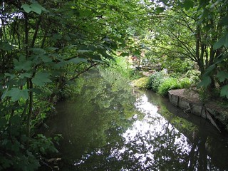
| Features | The suggested route takes in three villages steeped in history, a ruined palace, two castles and a Roman villa. At times the route runs alongside the River Darent, at other times through fields and woods.
At the start of the walk there is the Otford Solar System, which claims to be the only scale model of its kind in the world - see History below. Lunch is in Shoreham, which (January 2024) has 3 historic pubs to choose from plus two tea rooms and a vineyard. In the afternoon, you come to Lullingstone Park with its (early summer) orchids; its Visitor Centre offers exhibitions and information about the park (and has a café). Towards the end of the walk you pass Lullingstone Castle with its new visitor attraction, the World Garden, and Lullingstone Roman Villa (English Heritage). The main walk then continues to Eynsford passing under the impressive Eynsford Viaduct, but if you wish - and just before the Roman Villa - you can detour uphill to the Eagle Heights Wildlife Foundation - Birds of Prey Centre - before continuing on the Darent Valley Path downhill to Eynsford. The walk has two steep uphill sections and the first half can be muddy in winter. |
| Walk Options |
In winter and after periods of heavy and continuous rain the opening fields in the walk on your way to Sepham and Filston Farms can be very muddy. The mud can be avoided by taking an alternative route - the reverse of the closing leg of SWC Walk 43 - Otford Circular Walk. Alternatively, you could avoid the mud by starting the walk from the suggested lunchtime stop by travelling directly to Shoreham Station (or you could end the walk in Shoreham). In Lullingstone Park at point [7A] in these on-line Directions you can keep on the golfers access track, turning left as you reach it and head direct to Lullingstone Castle, omitting the ascent onto the ridge in the park, descent to Lullingstone Park Visitor Centre, and walk beside the River Darent to the Castle, saving 1 km - but if you have the time, the full walk is much nicer. You can cut 1.2km off the end of the walk by following the short cut at [*] in the Walk Directions. The walk can be extended by adding a section of SWC Walk 291 - Farninghamn Road to Eynsford, along the Darent Valley Way, to end your walk at Farningham Road railway station. This adds 5.5 km (3.4 miles) to the standard walk. |
| History |
Otford goes back to the sixth century when the Anglo-Saxons called their settlement Ottanford ('Otta's ford'). The Archbishop's Palace in Otford, the remaining fragments of which are on open view, once rivalled Hampton Court for splendour, until Henry VIII forced Archbishop Cranmer to surrender it in 1537. Construction of St Bartholomew's Church, Otford, began in 1060, with the tower being added in 1175. The church contains large marble memorials to Charles and David Polhill, great-grandsons of Oliver Cromwell. The Otford Solar System is a full scale representation of the spatial position of the planets at a moment in time (midnight on 01-01-2000) and with the inclusion of four of the nearest stars located in museums around the world, it can lay claim to being the largest scale model of its type in the world. The model was constructed by the village as a Millennium Project, built to a scale of 1: 4,595,700,000. At this scale, the Sun is a little larger than a football - 30.3 cm across - and at the centre of the model, it can be found at the rear of the village recreation ground, a disc mounted on a concrete pillar. The earth is the size of a small ball bearing - 0.3 cm across - located 32 metres from the Sun. Jupiter, the largest of the planets is 162 metres away, the size of a small ping-pong ball - 3.1 cm across. To be found at various locations in the village, all mounted on similar pillars, are Saturn, Uranus, Neptune and Pluto. Mars - due to its location being between two football pitches - is represented by a ground level disc. The Otford Solar System provides visitors of all ages with an extraordinary insight into the size of the solar system and the larger universe in relation to our small planet. The artist Samuel Palmer lived and worked in Shoreham from 1826 to 1834. He was the leader of a group who followed William Blake and called themselves The Ancients. Palmer's father, also called Samuel, rented the Water House by the river. What was Ye Olde George Inne has been renamed the Samuel Palmer pub. The Church of St Peter and St Paul in Shoreham has many interesting features, including an outstanding wooden rood screen spanning the width of the building and a stained glass window by the Pre-Raphaelite artist Burne-Jones. Shoreham Memorial Cross is a striking feature on the hillside above Shoreham Village and below Meenfield Wood. It was cut into the chalky hillside in 1920 as a memorial to the local men killed during World War One. It is 100 feet in length, and can be seen for many a mile. Lullingstone Park was a deer park from the Middle Ages until World War II, when the park was used as a decoy airfield – the heavy bombing so terrified the deer that they escaped. Species of tree that deer would not eat have been planted through the centuries, thus ancient hornbeam pollards remain. Lullingstone Castle (tel 01322 862 114) is the residence of the Hart Dyke family, having remained in the Dyke family for centuries, with the original house built during the reign of Henry VII. Its gatehouse is one of the earliest all-brick buildings in Britain. In the grounds is the World Garden, containing plants from around the globe, which is open to visitors on Friday, Saturday and Sunday afternoons between April and September (and Bank Holiday Mondays). The House is open for guided tours on Friday, Saturday and Sunday, and for free-flow (self guided tours) on Bank Holidays and Event Days only. Admission (2024) is £9 (with extra £2.50 for the house tour) and between £10 and £ 18 on Events Days. Lullingstone Roman Villa (tel 01322 863 467) was first occupied in 80AD by a rich Roman who practised pagan worship of the local water sprite in a room here, which later became a Christian temple. The ruins include two mosaic floors. It is normally open daily in summer from 10am to 5pm, and in winter (October to the end of March) on Saturdays and Sundays only from 10 am until 4 pm (not Christmas Eve, Christmas Day, Boxing Day, New Year's Day) and for all school half term weeks. Admission (2024) is £9.90. St Martin's Church in Eynsford is unusual in having retained the Norman ground plan with apsidal chancel. In about 1163, Thomas à Becket excommunicated Sir William de Eynsford III, the Lord of the Manor who controlled the patronage for this church. The excommunication was cancelled by Henry II and the issue became part of the quarrel which led to Becket's murder. Eynsford Castle (free entry) was built in the eleventh century and vandalised in 1312. John de Eynsford, who lived there, is said to have assisted in Becket's murder. Eagle Heights Wildlife Foundation - Birds of Prey Centre (tel 01322 866 577)- is open from 10.30am to 5pm (last entry 3.30pm) from 25 March to 31 October, usually 7 days a week, and in winter from 11 am until 4 pm on all days of the week apart from Tuesday and Thursday (closed on these days) - admission (2024) £12.95. The centre can be visited via an uphill detour from the main route, which links up to the walk extension to Farningham Road. There are fine views of the Darent Valley from the public footpath beside the Centre (without having to pay the entrance fee). The Centre houses over 100 species of birds of prey, including eagles, falcons, owls and an Andean Condor. There are handling displays on all open days. |
| Travel |
Take the train nearest to 10.30 am from Victoria Station to Otford. Journey time 35 minutes. Trains back from Eynsford are half-hourly and go to Blackfriars and Kentish Town during the week, Victoria at weekends; these are slower, but you can change at Bromley South for a fast train to Victoria. Buy a day return to Otford. If driving, Otford Station car park costs £3.50 (cheaper at weekends). Alternatively, there is a free public car park in the village, opposite the Bull pub. Eynsford Station has a small free car park. There are trains every 30 minutes from Eynsford to Otford. |
| Lunch |
Shoreham used to boast four fine pubs all serving more than acceptable food. Alas, post Covid-19, only two of these initially survived, although a third reopened under new ownership and a new name in 2022. Attempts to save the fourth pub - the Two Brewers - failed and the pub is being converted into housing. The three Shoreham pubs which are currently trading (January 2024) are the King's Arms, The Samuel Palmer and The Crown. The King's Arms pub (tel 01959 523 100)in Church Street reopend after a fire requiring extensive restoration work at the end of August 2022. Lunch is served seven days a week from 12 noon until 2.30 pm (later at weekends). The pub has comfortable informal indoor dining areas plus outdoor tables at its front and to its side, plus a large, covered - and in winter heated - marquee. Booking ahead is recommended at weekends and especially on days (Wednesdays in 2024) when excellent value, two course pensioner lunches are on offer. But the King's Arms claim to fame is that it has in its front wall the country's last remaining ostler box (like an enclosed little sentry box, where the ostler used to wait to attend to customers' horses). The second surving pub is the family run Crown pub (tel 01959 522 903) at 84 High Street, which serves home cooked, honest pub grub six days a week (closed Thursdays) Monday to Wednesday from 12 noon until 4 pm, Friday and Saturday all day from 12 noon, and on Sunday from 12 noon until 4 pm. This comfortable pub tends to be less busy than the King's Arms and is a very good alternative to the latter. The third pub is The Samuel Palmer (tel 01959 525 442) - previously known as Ye Olde George Inne, in Church Street. This 15th century pub was substantially rebuilt - and renamed - in 2021 by its new owners. Open for lunch Tuesday to Saturday from 12 noon until 2.30 pm, and until 4.30 pm on Sunday, with sharing platters and bar snacks available on all days until late including Monday. The fourth pub - the Two Brewers - at 30 High Street - as noted above is no more. For cafe food and lighter fare in Shoreham Village you have two choices, but only at weekends. The first is The Shoreham Aircraft Museum Tea Room - Battle of Britain Museum (tel 01959 524 416), open Saturday, Sunday and Bank Holiday Mondays, from 10am to 5pm. The Museum has a lovely tea garden which is a popular stop for SWC walkers not in need of a pub lunch. The second is the Honey Pot (tel 07546 696 623), open Friday, Saturday and Sunday, from 10am to 4pm. Wine buffs and lovers of English sparking wine might like to visit The Mount Vineyard tel 01959-524008, on Church Street, in the centre of Shoreham village - between Ye Olde George Inne and the King's Arms pubs. This vineyard has in recent years won awards for its wine tasting experience. Open from 12 noon to 6 pm Thursdays to Sundays and on Bank Holiday Mondays, you can sample the vineyard's wines whilst dining from their menu of sharing boards of cheese and charcuterie, stone baked pizzas and lite bites. Contact the vineyard if you wish to book a wine tasting tour in summer (from £ 35 a head) or in winter their hour's wine tasting (£ 30). Within the grounds of the vineyard you also find the Coffee Box , serving hot drinks and home-made cakes on Wednesdays and Thursdays from 10 am until 2 pm, and from Friday to Sunday from 10 am until 3 pm. |
| Tea |
Mid afternoon, the café at the Lullingstone Park Visitor Centre (tel 01322 865 995) is open daily to 5pm in summer, 4pm in winter. The suggested tea place in Eynsford used to be the Riverside Tea Room, just before the ford, but this is now permanently closed. For a pub-tea you have a good choice. The Plough (tel 01322 862 281) has an attractive riverside location and serves tea and coffee as well as normal pub fare. Other pubs in Eynsford are the Malt Shovel Inn (tel 01322 862 164), the Five Bells (tel 01322 863 135) and the Castle Hotel (tel 01322 863 162). |
| Updates |
No major changes. [Pre 2011 Editions] Many small updates - this edition, Book check and walk update January 2024. |
| Book |
This walk was originally published in Time Out Country Walks near London volume 1. We now recommend using this online version as the book is dated. The book contained 53 walks, 1 for every week of the year and 1 to spare. Here is our suggested schedule |
|---|---|
| Profile | |
| Help Us! |
After the walk, please leave a comment, it really helps. Thanks! You can also upload photos to the SWC Group on Flickr (upload your photos) and videos to Youtube. This walk's tags are: |
| By Train |
Out (not a train station) Back (not a train station) |
| By Car |
Start TN14 5QY Map Directions Return to the start: Finish DA4 0HP Map Directions Travel to the start: |
| Amazon | |
| Help |
National Rail: 03457 48 49 50 • Traveline (bus times): 0871 200 22 33 (12p/min) • TFL (London) : 0343 222 1234 |
| Version |
Jan-24 Marcus |
| Copyright | © Saturday Walkers Club. All Rights Reserved. No commercial use. No copying. No derivatives. Free with attribution for one time non-commercial use only. www.walkingclub.org.uk/site/license.shtml |


Walk Directions
- [1] Coming off the London train, cross the footbridge over the railway line and exit the Otford Railway Station building. Turn left under a barrier into the station car park and in 40 metres, on the right-hand side, go through the gap in the railings and take the tarmac path heading west away from the station, gently downhill, soon with an open field on your left-hand side. Keep to this path through a bend to the right. A wooden swing gate takes you through to the churchyard of St Bartholomew's Church, which is worth a look inside (the old south door is no longer used and the new entrance is a set of modern doors on the north side).
- From the church, head north-west towards the main road, passing the war memorial on your right-hand side.
- A detour to the left here would take you in less than 100 metres to the gatehouse and north-west tower, virtually all that remains of Otford Palace.
- To continue the walk, go over to the far side of the village pond, in the centre of a roundabout; the duckhouse here is Britain's smallest listed building. Take the road on the left, westwards, by the Crown Inn (no longer a pub since 2018), soon passing the Hospices of Hope Otford Tea Room and Gift Shop tea on the left and the seventeenth-century Forge House (now a restaurant) on the right.
- Keep on this road. In 120 metres (from the roundabout), by the Bull pub (part of which dates back to 1500), a short diversion to the back of the public car park on the opposite side of the road will take you to a map showing the planetary locations of the Otford Solar System. In a further 200 metres down the road you pass on the left Pickmoss , a medieval open-hall house, and in a further 50 metres, on your right, the Darent Valley Path . The alternative route - reversing Book 1 - Walk 43 Otford Circular - starts here.
- The alternative route: take the surfaced drive, with the river on your left, and in 75 metres, at the end of the drive, keep ahead on a footpath, soon with allotment gardens on your right and a woodland strip to your left, with the river down below you. Go through a wooden kissing gate and keep ahead, now along the left-hand edge of a large open field. In 230 metres the path swings to the right and you go through a metal kissing gate. Keep ahead, gently uphill, on a path between fields, with a mesh fence on your left. In another 230 metres go through a metal kissing gate, cross a drive and go through another metal kissing gate, to keep ahead on a broad grassy way. In 350 metres go through another metal kissing gate and head through a woodland strip, soon with golf links on your left. In 100 metres cross a golf access path and keep ahead through the woodland. In 450 metres the path comes out onto a surfaced lane, passsing to the side of a 'freestanding" metal fieldgate (waiting to be linked by fencing to the round wooden bollards on its either side - summer 2020) where you turn left downhill, quite steeply, following signs for Home Farm and the Old Mill. In 200 metres at the bottom of the slope, with Old Mill House on your left, cross the River Darent and keep ahead between properties. Where the road ends and becomes an earth track, with a car ford directly ahead at a major junction, cross a narrow footbridge over the River Darent and at the path junction, take the left-hand bridleway, with the river on your left and Robins Wood on your right-hand side. In 210 metres the bridleway swings to the right and comes out by Kennel Cottage on your right. Head up the access road (Water Lane), with hedges on either side, and in 200 metres you come to Filston Road. Cross over, slightly to the left, and continue with the main route up the trackway.
- The Main route After passing Pickmoss, cross over the River Darent, to then pass the iron gates of eighteenth-century Broughton Manor on your left. In 100 metres the road goes over a stream and in a further 100 metres, just beyond a wooden bus shelter on the north side of the road, you come to a concrete pillar representing the planet Uranus .
- [2] Immediately after this pillar, turn right through a kissing gate on to a signposted and well-used public footpath, across an open, grassy field, your direction 330°. In 200 metres pass through a barrier and continue ahead on an enclosed path, with a post and wire fence on your left and a hedge on your right. This next section now has a gravel surface and should be less muddy in winter than before.
- In 400 metres the path bears left to go through a hedge in a field boundary and across a ditch, then through a metal squeeze stile. Continue ahead on an enclosed path. In 90 metres the path swings to the left then right to cross a stream on a slab of concrete (a small hump bridge with brick headwalls) and in a further 10 metres keep ahead (slightly right), to pass through a wooden barrier with a yellow footpath disc on it, along a path, your direction west, with a wire fence on your right. In 100 metres, at a path junction, take the right-hand fork: in summer the trees and hedgerows on either side of the path form a canopy over it. In 130 metres the path merges with a farm track from the right, with a metal fieldgate over to your right. 10 metres ahead, you have a choice of routes, both about the same distance.
- To go past the concrete pillar representing the planet Pluto , turn right along a path, which can be overgrown in summer, with woodland to your right, and a fence and hedge to your left, with a vast open agricultural field beyond it, your direction 30°. In 240 metres you pass the pillar (Pluto) on your right-hand side. Continue along the path, now between hedges with open fields beyond on either side. You are walking parallel to the Main route over the fields away to your left. In 400 metres go over a farm track crossing with metal fieldgates on either side and continue ahead on what is now a car wide earth track, your direction due north. In 250 metres the track ahead may be blocked by metal barriers ( missing January 2024) with a sign "Permissive path avoiding farm buildings" pointing to the left. Turn left through the hedgeline on your left onto a permissive path and keep ahead on this path between fields. In 145 metres the path joins the path on the main route at a T-junction with it. Turn right and continue with the Directions below for the main route, viz heading towards Filston Farm [3A].
- To follow the original (main) route, however, keep on this grassy farm track, which in 220 metres comes to the corner of an orchard [3]. Instead of veering left then right with the main path towards Sepham Farm and its oasthouses, turn right and pass to the left of a pair of metal fieldgates, with a yellow footpath disc on one of them, to continue along the edge of the orchard, your direction 40°, soon passing under mini-pylons.
- In 100 metres, at the end of the orchard on your left, ignore the public footpath turning to the left, and continue ahead between large open fields on a clear earth track, heading in the direction of Filston Farm in the distance. In 225 metres you pass a field boundary on your right. You now have a wire fence on your right. Keep ahead, now on a path between fields. In 200 metres you pass through a field boundary and the path swings to the left then right, to then keep ahead. 190 metres you pass on your right the permissive path to Pluto and keep ahead. [3A].
- In 75 metres, with the entrance to the farm ahead of you, with an industrial shed with feed hopper ahead on your left, Do not enter the farm (the route of the original directions) but instead turn left then swing right over a farm apron, to go through a pair of metal fieldgates (usually propped open), then bear left to head up a gravel track to the immediate left of the farm access road, with a hedge between. In 75 metres at the top of the track, you come out onto Filston Lane . Turn right along this car road.
- [4] In 100 metres you pass on your right-hand side the entrace to Filston Oast . You may now prefer to walk along the road's grassy verge on your right. In a further 170 metres you pass a bus stop on your right and on the road surface is a 30 MPH speed sign. In 10 metres and just before you come to Water Lane on your right, turn left passing to the right of a metal car blocking barrier to head up a trackway between hedges, your direction 290°.The alternative (reverse of Otford Circular) route joins here.
- Climb steadily up this track and in 300 metres the track narrows to a path. In 20 metres you pass to the right of a rusty metal fieldgate and in a further 8 metres go through a metal swing gate, in the bottom corner of a large grassy field. You now head steeply up the right-hand side of this field on a grassy way, soon with Meenfield Wood over to your right. In 150 metres and just before a convenient seat, bear right to pass a large mature beech tree and turn right through a metal kissing gate with a metal fieldgate to its left, on to a wide woodland path, gently downhill, along the contours of the hill, initially with woodland on both sides, and latterly with woods on your left uphill slope, and with bushes or treeline on your right before the dowhill slope.
- In 600 metres you come to a path crossing, with a sign for Meenfield Wood on your left, with steps up and down. [!] Here turn right down seven earthen steps with wooden risers, to head down the left-hand edge of a grassy field towards Shoreham, following the line of a dilapidated wire fence, your direction 120°. On your left you have a good view of the Shoreham Cross WW1 Memorial .
- In 80 metres go through a wooden kissing gate and down two wooden steps to continue down a path between hedges. In 130 metres go through a metal kissing gate, with the entrance to Centenary Wood on your left-hand side. Continue down this path, with intermittent steps, latterly with playing fields on your left-hand side.
- In 180 metres you come down to Shoreham's High Street . Turn left here if you wish to visit the Village Stores, some 150 metres up the road, or if you wish to have lunch at the Crown pub , further along the road. But for the main route, turn right on the High Street. Immediately on your right you have the Shoreham Aircraft Museum Tea Room - Battle of Britain Museum , a light lunch option at weekends. Continuing along the High Street you next come to the Honey Pot tearoom on your left - again, only open at weekends. Just past this, turn left into Church Street. In 180 metres you come down to the King's Arms pub on your right-hand side, one of your lunch pub options in Shoreham.
- Alternatively, continue along the road, cross the river and follow Church Street up to the right; on your left-hand side, beside a bungalow, you have the (long) access road leading to the Mount Vineyard , a venue for wine buffs, serving light lunches, and coffee and cakes from its Coffee Box cafe. A short distance further along Church Street you come to The Samuel Palmer pub (formerly knowns as Ye Olde George Inne) on the right, opposite the entrance to the Church of St Peter and St Paul.
- From the Kings Arms, turn right and go along the road, cross the river and turn left into Darenth Way. Pass to the left of Water House and keep to the riverside path, with the River Darent on your left-hand side.
- In 420 metres, at the end of the riverside path at a path junction, turn left to cross the river on a footbridge with metal railings. At the end of the bridge turn right and in 50 metres you leave the Darent Valley Path to turn left uphill on a car lane, westwards. In 130 metres at the top of Mill Lane you come to a T-junction with the main road (the Crown pub is 80 metres away on your left here).
- Cross over the road and take a permissive path directly opposite, the Millennium Footpath, which runs parallel to the road on your right-hand side, steadily uphill. In 100 metres go through a metal kissing gate and follow a grassy path up the right-hand field edge, following a line of circular tree trunk bollards, which in 70 metres swings to the left in an arc. In a further 60 metres you reach the top corner of the field.
- Exit the field through a metal kissing gate to the right of a metal fieldgate. Continue uphill for 25 metres and pass by a metal vehicle barrier to come out onto a road and turn right downhill. In 100 metres continue ahead at a road junction, but in a further 80 metres, turn left at another junction into Cockerhurst Road (Just before this junction there is an interesting little memorial stone up steps on the bank to your left; the biblical quotation is from Hosea 2:14.)
- The road heads down to a dip and then heads steadily uphill, with tall beech trees on either side. In 350 metres, and 5 metres beyond a metal fieldgate on your right, and with a large bungalow (Combe Vale) on your left-hand side, [5],[!] turn right up a footpath, marked by a metal footpath sign and a ground level concrete sign, your direction 15°. Head up this narrow path, quite steeply, as it meanders through light woodland initially, then with a large field behind a fence on your left-hand side.
- 300 metres from the road, pass to the right of a redundant stile and follow the left-hand edge of a vast open field, your direction northwards, towards Homewood Farm. Keep on this path, with trees and then hedges on your left-hand side.
- In 400 metres you come to the end of the field, with a small house on the right-hand side. Keep ahead, slighty left and then [!] head down a narrow path with a high wooden fence on your right and a hedge to your left. In 100 metres, you join a concrete access road ( for Greenacres) and continue ahead, your direction 350°.
- In 200 metres, at a T-junction with a car road, pass through a gap to the right of a metal fieldgate and turn right down the road, with hedges on either side. In 85 metres, at a bend in the road, ignore the access road to your left (to the Barrons) but 8 metres later [!] turn left over a stile on your left into Home Wood [6] .
- These woods, and the golf course up ahead, are part of Lullingstone Park. When this walk was devised the directions through this Country Park followed the route of a published trail, but the numbered posts which marked out this route are no longer present. Not all of the paths used are shown on the OS map.
- 5 metres inside the wood, turn right on to a wide path, downhill, your direction 100°. In 40 metres follow it round to the left, your direction now 40°.
- In 150 metres cross over a path junction and pass to the right of a metal fieldgate and then keep ahead at a junction with a track coming down from the right. In a further 150 metres, having ignored paths off to both sides, you come to a T-junction, with a marker post directly ahead of you. Turn right and then in 20 metres turn left into a very wide grassy avenue going gently downhill between Upper and Lower Beechen Wood, still heading north-east.
- In 400 metres you come down to a permissive bridleway [7], with a pair of wooden fieldgates 10 metres ahead of you, leading on to a golf course.
- The suggested route is to keep ahead to pass through a gap to the right of these gates to come out on to the golf course BUT if you find the way ahead blocked through undergrowth, turn left for about 15 metres then turn right to pass through the undergrowth, to soon come out onto the golf course. Once on the course bear left across grass for 75 metres to reach a gravel track. [!] As you come out into the open beware of golfers playing across your route from a raised golf tee on your left. Turn right on to this gravel track, heading east.
- If you wish, you could now simply follow this gravel track all the way through the golf course. In 1.25km you would come out on to the Darent Valley Path in front of Lullingstone Castle, resuming the directions at point [8] below. However, this would miss out a nice stretch of the walk and you would bypass the Lullingstone Park Visitor Centre.
- For the recommended route, follow the gravel track, and in 95 metres you have a golf bunker on your left. In a further 60 metres - and some 70 metres before you come to a golf bunker on your right [!] leave the track and turn half-left onto an indistinct grassy path going quite steeply up a grassy slope, your direction 60°.
- The path swings to the right and after some 110 metres, your way levels out, with hole 4 over to your left. Bear right over grass and in 90 metres cross over a broad grassy path. You next pass to the left of hole 13 Tee. Continue ahead to cross a green with a bunker behind. Now over to your right you have a broad grassy path, which you join. This path descends for 250 metres to go back across the gravel track, which has curved round to the left in the valley [7A].
- [!] If you wish to head direct to Lullingstone Castle by omitting the ascent onto the ridge path,the walk along the ridge,the descent to the Visitor Centre and the walk beside the River Darent, turn left on the gravel track and keep ahead, in some 450 metres leaving the Park as you reach the Castle.
- The Main route continues as follows: cross over the gravel track, with a marker post on your left. Head gently uphill over grass as your way swings to the right, then left, to pass a clump of trees, and aim for the golf green ahead. Pass the green and at the back boundary, with wooden benches over to your left and woodland behind, turn right .
- Follow the boundary edge, passing a number of low posts with tops with faded paint. In 60 metres [!] by a low post with a blue arrow, bear left to pass through a gap in the woodland strip on your left, and in 20 metres you come out into the open, where you bear right for an further 20 metres to join a broad grassy permissive bridleway - the ridge path.
- You now have fine views across the Darent Valley below, with the brick gatehouse of Lullingstone Castle on your left and Lullingstone Park Visitor Centre down on your right.
- Turn right and go along the ridge on the broad grassy permissive bridleway, soon taking the left fork at a Y-junction, your direction 210°. In 200 metres, with a bench seat on your right, the path goes between hedges. In another 100 metres, as the path swings left, turn left downhill on a car-wide track, between hedges and trees, in 200 metres reaching Lullingstone Park Visitor Centre (which has a café).
- Coming out of the Visitor Centre, turn right through the car parking area, go past the Acorn Adventure Play area and immediately turn right onto a gravel path which swings down to the right to a bridge. Just before the bridge (which you do NOT cross), turn left onto an attractive riverside path, signed "Lullingstone Castle and Roman Villa", and head along the river bank with the River Darent on your right-hand side. In 500 metres, by a weir in the river to your right, go through a wooden kissing gate [8] and continue straight on towards the gatehouse of Lullingstone Castle.
- Walk past the front of the gatehouse and head along the drive, with car parking spaces on your right. Now continue ahead, northwards, on a tarmac lane. In 200 metres you pass on your left-hand side Mulberry Stables. To your right you now have horse paddocks. Keep ahead along the lane, soon passing on your left-hand side Lullingstone Park Farmhouse. In a further 350 metres you come to a khaki coloured large, steel clad shed on your left-hand side which houses Lullingstone Roman Villa.
- [*] You can shorten the walk by 1.2km at this point by turning right to cross the river on a bridge to the left of the car park. In 600 metres this private road – which is also a public footpath – comes to a T-junction with the A225, where you turn left. In 300 metres you go under the railway bridge and turn sharp right to reach the station.
- For the detour to Eagle Heights Wildlife Foundation and viewing point, some 20 metres before you come to the Roman Villa, take the signposted footpath on your left , initially up earthen steps, through a woodland strip. The path meaders uphill through woodland and comes out into a field, where you continue uphill along its left-hand edge. Some 500 metres from the road, near the top of the slope, as you approach a field boundary, turn right just before it and walk beside a hedge on your left, a a level way, with fine views to your right. In some 330 metres the hedge ends and you keep ahead through a field. In a further 270 metres you come out onto an access road. Here, for The Eagle Heights Centre , turn left , soon passing Hulberry Farm on your left. Beyond it, turn left for the entrance to Eagle Heights. After visiting the Centre, return to the point where the path came out to the access road. Here turn left to continue on the Darent Valley Path, now slanting downhill, to your right. In 90 metres pass through a gap in the hedge field boundary ahead of you, and continue downhill, now half left. In 350 metres the path comes down to the railway which you cross via stiles on either side. On the far side continue ahead for a further 260 metres to pass pipe barriers as the path comes down to the road, to rejoin the main route, some 70 metres before the junction with Sparepenny Lane.
- To continue on the main walk without taking the detour to Eagle Heights, keep ahead on the tarmac lane. In 370 metres you pass on your left-hand side the car access road heading uphill to Eagle Heights. Keep ahead on the lane and in 250 metres go under Eynsford Viaduct (Bridge 533 SBJ, built in the nineteenth century with bricks made in Brick Field, just above the east bank of the river) and go straight on, with the River Darent now closer by on your right-hand side.
- In 250 metres the tarmac lane - now a tarmac road - swings sharply to the right. On your left the footpath coming down from the Eagle Heights detour joins the road. In 70 metres, at the junction with Sparepenny Lane on your left, keep ahead on the road following the direction for Eynsford . In 200 metres with the River Darent now on your immediate right you come to the Plough pub on your left-hand side (one of your walk-end refreshment options). Keep ahead on the road to go over the narrow town bridge with a car ford below to its right, to come on your left-hand side to the closed Riverside Tea Room. Just beyond the tea room the road joins the main road, the A225, at a T-junction. (Note: for walkers wearing leather boots, the ford to the right of the bridge makes for an excellent boot wash).
- To visit the ruins of Eynsford Castle, which is about 400 metres away, turn left on the main road and carry on through the village, passing the Five Bells pub on your right-hand side. Opposite the Castle Hotel, turn left on a tarmac lane signposted Village Hall and follow it round to the right to find the Castle car park and ruins.
- For Eynsford Railway Station, turn right on to the A225 road, with St Martin's Church opposite. You soon pass the Malt Shovel Inn on your left-hand side and go uphill for 800 metres, turning left into the station approach road just over the brow of the hill. Trains back to London are on the far platform (platform 1) over the footbridge.
- Alternative route to the railway station avoiding the main A225 road . At the junction with the A225,cross over with care (there is a pedestrian crossing to your left) and go through a gate into the churchyard of St Martin of Tours. Follow the path uphill and round to the left and exit the churchyard by a black metal gate in the top left-hand corner. Go straight ahead over a drive, pass by a cycle barrier and enter a surfaced alleyway between fences, to go gently uphill. In 90 metres exit the alleyway passing another barrier onto a residential road - Pollyhaugh. Turn right along this residential road with detached houses on either side. After 700 metres, with Pollyhaugh ending and the road continuing as St Martins Drive, you come to a T-junction. Turn right down Eynsford Rise. At the bottom of this road you have Eynsford Railway Station directly ahead of you.