Glynde to Seaford walk
The best walk in the book! A South Downs ridge, picture postcard Alfriston, Cuckmere Haven (beach), and cliffs with views of the Seven Sisters. Long but worth it.
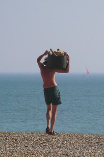
Cliff Edge - is he a mate of Marty Wilde and Billy Fury?
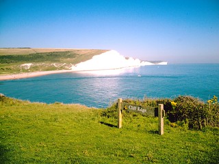
View of Seven Sisters from the west. David A. Vivitar 5199
Aug-07 • magyardave2002 on Flickr
swcwalks book1 walk31 walkicon 1468571329

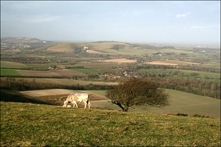
The South Downs near Firle
book1 eastsussex walkicon swcwalks walk31 8370552207
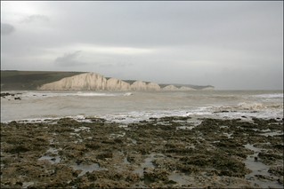
The Seven Sisters cliffs at Cuckmere Haven
sussex book1 walkicon swcwalks walk31 8390759614
Book 1, Walk 31, Glynde to Seaford 1
Seaford beach, 18 June '05
book1 seaford glynde swcwalks walk31 tocw131 358654446
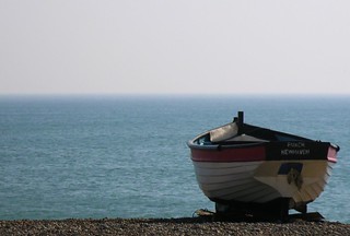
Book 1, Walk 31, Glynde to Seaford 2
Seaford beach, 18 June '05
book1 seaford glynde swcwalks walk31 tocw131 358654450
The South Downs & Alfriston
| Length | 23km (14.3 miles), 7 hours. For the whole outing, including trains, sights and meals, allow at least 12 hours. |
|---|---|
| Toughness | 8 out of 10. |
| OS Maps | Explorer OL25 (was 123) or Landrangers 198 & 199. Glynde, map reference TQ 457 087, is in East Sussex, 12km east of Brighton. |
| Features |
Everyone's favourite walk in TO Book 1. It starts with a South Downs Ridge walk. Lunch is in the picturesque village of Alfriston. After lunch there is Cuckmere Haven (a pretty river valley), and a coastal cliff walk into Seaford. You can swim at Cuckmere Haven or Seaford. Near the start, the route goes through Firle Park and then follows the South Downs Way for much of the day, with not as much climbing as Walk 25's arduous route into Hastings, and with marvellous views across the lush valleys to the north and down to the sea. There are three lovely villages to enjoy during the course of the day, all with open churches: West Firle, West Dean, and (the suggested lunchstop) the old smuggling village of Alfriston, which likes to call its church a cathedral. There is slightly further to walk after lunch than before it. From Alfriston the route follows the riverbank through the Cuckmere Valley and through Friston Forest down to Exceat (pronounced Ex-Seat), an extinct village on the edge of the Seven Sisters Country Park, where there is a Visitors’ Centre. The Vanguard Way then leads through the Seaford Head Nature Reserve – hoopoe, bluethroat and wryneck have been seen here – to the beach at Cuckmere Haven. This is in season a good enough place to take a dip or just to enjoy a front-stalls view of the white cliffs of the Seven Sisters. Finally there is a walk along the coastal path and down into Seaford, a seaside town with a long esplanade and reconstructed shingle beach. |
| Walk Options |
There are occasional buses linking Alfriston with Lewes, Glynde, Firle and Seaford. However, the best option is the frequent bus service from outside the suggested early tea place in Exceat to either Eastbourne or Seaford. After lunch in Alfriston and your walk beside the River Cuckmere to Litlington, instead of heading up to Friston Forest, you can climb up and over "High & Over Hill" (on SWC 90) with its magnificent views, before dropping down to Exceat to rejoin the main Book 1 walk directions. For the best of South Downs long walks, try adding the opening leg of Book 2, Walk 25 - Lewes via West Firle Circular. Starting in Lewes, you climb Mount Caburn and descend to Glynde. This opening leg with lovely views takes exactly one hour and adds 3.1 miles to your main walk, which now becomes 17.4 miles. Recommended for those who like to go long. |
| History |
Firle Place (tel 01273 858567) was the seat of Sir John Gage, who helped Henry VIII with the dissolution of the monasteries, despite retaining the old religion himself. During the walk you get a good view of Firle Tower, a watchkeeper's residence. The House is open to visitors (2020) from 07 June to 27 September from Sundays to Thursdays from 2pm to 4.30pm. Its licensed tea room (no charge for entry) is open on House opening days from 12 noon to 5pm, serving light lunches, cakes and teas. Admission to the House (2020) is £9.50. The Church of St Peter, Firle, contains an alabaster effigy of Sir John Gage wearing his Order of the Garter and lying beside his wife Philippa. It also has a John Piper stained-glass window in warm colours, depicting Blake's Tree of Life. Alfriston was once a Saxon settlement. In 1405, Henry IV granted the town the right to a market, hence the old market square cross (though now without its crosspiece) which was supposed to help ensure honest and fair trading. The narrow streets are lined with fourteenth and fifteenth-century houses. In the early 1800s smugglers would run contraband via Alfriston and Cuckmere Haven, with farmers driving their sheep to help cover the smugglers' tracks. The Parish Church of St Andrew, Alfriston – known as the 'Cathedral of the South Downs' – was built about 1360, all at one time and with no later additions. But because there were no local squires and manors the church is rather bare inside, with few memorials. It has a basin and ewer on the Sepulchre at the north side of the chancel that came from the Holy Land. The Alfriston Clergy House (tel 01323 870 001) was the first building to be acquired by the National Trust, in 1896, for £10 (which makes the £6.00 entrance fee - 2021 - seem rather steep). A Wealden hall house with thatched roof, it contains a medieval hall and has a cottage garden with some rare specimens. Post Covid lockdown 2021, it is open from 21 May on Fridays and Saturdays, and from 11 August additionally on Wednesdays and Thursdays, between 11 am and last visits 3 pm. Pre-booking required until all Covid restrictions are relaxed. West Dean Church has probable Saxon elements, and next door to it is a medieval parsonage with a colourful garden. The parish priest from 1891 was the Revd George Lawrance, who believed in captive audiences – it is said that he used to lock the church door before delivering his sermons. The chalky cliffs of the Seven Sisters developed under the sea, 70 to 100 million years ago – the chalk is mainly made up of microscopic fossils. Later the chalk cliffs dipped beneath the sea again and came up covered in silt and sand, still visible as the top layer. There are also layers of flint – the supercooled liquid leached out of chalk to form globules. The Exceat Visitors’ Centre has an exhibition on the development of the cliffs and river. Seaford Museum in Martello Tower No 74 , on the front at Seaford, is the most westerly of a chain of 103 similar fortifications running from Aldeburgh on the east coast. It was built in 1806 against a threatened Napoleonic invasion and houses the Seaford Museum of Local History. The Museum is usually open on Saturdays, Sundays and Bank Holidays from 11am to 4pm and in summer also on Wednesdays from 2pm until 4pm. The Museum closed in October 2017 for refurbishment and reopened in October 2018. From the Museum's website it appears that entrance is free for individuals, with a charge (2021) of £ 2.50 a head for groups. |
| Travel | Take the train nearest to 09.00 hrs from Victoria Station to Glynde (change at Lewes). Journey time is 1 hour 27 minutes, longer on Sundays because of longer connections. Trains back from Seaford generally run twice an hour, again changing at Lewes. Journey time is just over one and a half hours, longer on Sundays when it is quicker at certain times to change at Brighton. Buy a day return to Seaford, which in practice is accepted to Glynde. Mid-week walkers with senior railcards can take the 09-47 hrs train from Victoria: the lunchtime pubs in Alfriston, busy at weekends, are less busy mid-week. |
| Lunch |
There are four pubs in Alfriston which can serve as a lunch stop, some 11.4 km into the walk. The first you come to, and the suggested lunch place, is the George Inn (tel 01323 870 319), built about 1397, with a treacherously low-beamed ceiling. It serves lunch midday to 2.30pm daily. The food is good although some dishes are expensive. Groups of six or more should phone ahead. The pub has a pleasant back garden for outside dining in summer. The other pubs are the Star Inn (tel 01323 870 495) on the High Street, directly opposite the George - purchased in 2019 by the grandaughter of the late Lord Charles Forte - and reopened in October 2020 after extensive refurbishment: down the road you come to Ye Olde Smugglers Inn (tel 01323 870 241) on Waterloo Square (popular with real ale drinkers), and at the far southern end of the High Street, the Wingrove Inn (tel 01323 870 276) There is a great village shop, if you fancy a picnic by the large church, with lovely views over the valley. Other alternatives for lunch in Alfriston, Chestnuts Tea Room (tel 01323 870 298) open to 5pm during the summer, 5.30pm at weekends (closed Mondays and Tuesdays) and The Singing Kettle (tel 01323 870 723) open daily until 5pm. If you can hold off hunger pangs for a further 35 mins until you reach the village of Litlington, your reward will be lunch at the excellent - and popular - Plough and Harrow pub (tel 01323 870632). This 17th century country pub serves lunch and dinner Monday to Saturday from 12 noon until 9pm, and on Sundays from 12 noon until 7pm. Booking ahead on weekdays is advisable, and is essential at weekends. Nearby in Littlington is the Littlington Tea Gardens (tel 01323 870222) for a late lunch, brunch or early tea. |
| Tea |
In Exceat, the early tea stop on this walk is the Saltmarsh Farmhouse - formerly the Exceat Farmhouse - (tel 01323 870 218) set well back from the A259 at Exceat. It offers cream teas and other food and drink until 5pm (but times are changeable in winter – please check). Opposite this cafe in one of the car parks is usually parked an ice cream van. Also in Exceat, by the bridge, is the Cuckmere Inn - formerly the Golden Galleon - a popular pub with nice views from its terrace. In Seaford, for those in need of sustenance, and near the railway station, you have an excellent chippie, Trawlers Fish and Chip Restaurant (tel 01323 892 520) open until 9pm Tuesday to Saturday (Monday 8.45). Closed Sundays. Open most Bank Holiday Mondays. Tea and coffee can be obtained in various pubs including the Wellington (tel 01323 890 032) and the Plough Inn (tel 01323 872 921). There are also some cafe-bars in the town. Within Seaford railway station you have Steamworks mini-pub and bar, serving an excellent range of draught beers, spirits and soft drinks. It makes for a comfortable stop to while away time if you have a wait for your train home. For Elevenses , if you have a twenty minute connection at Lewes station, try the Runaway Cafe between platforms 2 and 3. It has an excellent selection of cakes, teas and sandwiches. |
| Updates |
Minor updates June 2017, although you should not get lost using the 2010 edition of the TO Book. Lunch and tea stop options updated November 2020. Book check and walk update July 2021. |
| Book |
This walk was originally published in Time Out Country Walks near London volume 1. We now recommend using this online version as the book is dated. The book contained 53 walks, 1 for every week of the year and 1 to spare. Here is our suggested schedule |
|---|---|
| Profile | |
| Help Us! |
After the walk, please leave a comment, it really helps. Thanks! You can also upload photos to the SWC Group on Flickr (upload your photos) and videos to Youtube. This walk's tags are: |
| By Train |
Out (not a train station) Back (not a train station) |
| By Car |
Start BN8 6RU Map Directions Return to the start: Finish BN25 2AR Map Directions Travel to the start: |
| Amazon | |
| Help |
National Rail: 03457 48 49 50 • Traveline (bus times): 0871 200 22 33 (12p/min) • TFL (London) : 0343 222 1234 |
| Version |
Jul-22 Marcus |
| Copyright | © Saturday Walkers Club. All Rights Reserved. No commercial use. No copying. No derivatives. Free with attribution for one time non-commercial use only. www.walkingclub.org.uk/site/license.shtml |


Walk Directions
- [1]. From platform 2 of Glynde Railway Station walk up the steps from the station to the road and turn right across the bridge over the railway, over the railway line, your direction 165°.
- Curve round to the right with the road past the former Trevor Arms pub on your right (closed and awaiting redevelopment 2021). 50 metres beyond the pub [!] , just beyond numbers 11-16 Trevor Gardens, turn right off the road, marked by a half-concealed footpath post with a yellow arrow (Beddingham 1 mile).
- An alternative, simpler and better route to the footpath route, parts of which can be very muddy in winter or smothered in high crops in summer, is to continue on the road. In 580 metres you will come to the A27; cross with care, and go straight ahead. This is point [2] below.
- If taking the footpath, keep ahead with a metal link fence on your left hand side, your direction 260°. In 15 metres you come into a garden where you walk straight ahead along the grass. After 20 metres cross a driveway. Keep straight on and after 50 metres cross a stream over a plank bridge and continue ahead with a hedge on your right and a football pitch on the left.
- After 50 metres go straight through the gap in the hedge and walk along the right hand edge of the field in the same direction.
- After 150 metres at a wooden footpath post on the right follow the yellow arrow across the field, your direction 225°. After 400 metres fork left and in another 100 metres you reach a stile with a metal fieldgate to its right.
- Cross the stile and turn half left across the field towards the concrete underpass under the A27. Cross it and on the far side walk straight ahead through the farmyard, passing to the left of a telegraph pole. 30 metres beyond the pole you come out on to a minor road.
- Turn left down the road, your direction 75° and in 70 metres you pass a white house called Comps on your left. After 450 metres you come to a T-junction (where there is a junction with the A27 on your left). [2] Turn right your direction 195° (or continue ahead after crossing the A27 if you took the alternative road route).
- In 300 metres turn left down the driveway, signposted Preston Court, going due east. Continue ahead for 190 metres, and when the concrete road curves right, you go slightly left to a stile to the right of two painted metal fieldgates.
- Cross the stile and turn three-quarters right into the field, heading towards a metal fieldgate 200 metres away on the far side, your direction still east.
- Go though the gate and walk along the right-hand edge of the field. At the top, go through the small wooden gate (or over it if padlocked) and straight ahead upwards, through a field boundary, and down the middle of a field, your direction initially 75°.
- In 150 metres, the path, now car-wide, passes a barn on your left. Follow the path as it bends around to the left and after 80 metres you come to a T-junction where you turn right on to a concrete car-wide track, your direction 75°.
- In 190 metres you pass the entrance to Preston House (marked on the OS map) on your left. Continue along the track for another 100 metres to reach the road at a junction.
- Cross the road and take the road ahead going half-right following the footpath yellow arrow. 50 metres takes you through a white wooden gateway into Firle Park with the driveway for Firle Place ahead. Immediately through the gate, turn right off the drive, following a hedge on your right, your direction due south. Off to your left you can see Firle Tower on the distant hilltop.
- In 100 metres go through a wooden kissing gate and head half-left towards the left of the tennis court ahead (also to the left of the church) your direction 145°; in summer you may not be able to see these until you get closer. 280 metres brings you to a wooden kissing gate directly to the left of the tennis court, past some young trees.
- Once through the gate, go half right towards a car-wide track. Here turn right between two metre high walls. In 100 metres you come out on to the roadside with the Ram Inn on your right. Turn left along the tarmac road into West Firle village, heading due south.
- In 110 metres you pass Firle Stores and Post Office on your left and bear right with the road. 25 metres further on turn left off the road up the passageway leading to the Church of St Peter, Firle (the entrance is to the right).
- With the church entrance behind you, go straight ahead to exit the churchyard and turn right down the road, your direction 295°. After 65 metres you come to a T-junction.
- Turn left , your direction 190° initially, into the private road which has a notice ‘Bridleway. No motor vehicles.’
- In 85 metres you come to the end of the brick and stone farm building on your left. Keep straight on, ignoring ways off until in 150 metres at a fork in the path, take the left (main) fork . [3].
- Follow the track with a stone wall on your left, gently uphill. After 500 metres there is a stone gateway with a wooden gate over to the left. Ignore the minor path to the right going into the trees and bear right for 15 metres to a set of double fieldgates. Go through the gates, and keep ahead along a wide track, with open fields to your left and a line of trees to your right, steadily uphill towards the ridge ahead, your direction due south. Firle Tower is now much closer, behind and to the left.
- Ignore ways off and 550 metres up this track go through the wooden swing gate to the right of a metal fieldgate and walk straight ahead uphill. After 90 metres, before getting to the top of the hill, the path veers left towards the top of the ridge, your direction 170° initially.
- Follow the path now more steeply uphill for 400 metres as it leads you to the top of the ridge. Make for the fence that runs along the ridge top. On a clear day you can see the sea on your right with Newhaven prominent at 220° and Seaford just visible at 190°.
- Turn left and walk along the ridge top with the fence on your right hand side going east. You now follow the South Downs Way for the next 5.5km all the way to Alfriston.
- In more detail: Go uphill for 400 metres until you come to a wooden gate which takes you through a mesh and barbed wire fence. Through the gate, continue along the ridge path, on a grassy way. Another 300 metres brings you to the high point of Firle Beacon where there is an Ordnance Survey triangulation point marking 217 metres, the highest point you reach on the walk.
- Continue ahead for 1km and then descend to go through a wooden gate with a metal fieldgate to its right. In 50 metres go through another similar gate and straight on, parallel to the tarmac road and car park on your left [4].
- At the end of the car park go through a wooden gate with a metal fieldgate to its left and carry straight on along a wide flinty track.
- In 700 metres at a post with a blue arrow [!] fork left , on the South Downs Way and make for a field corner ahead. In 200 metres at this corner and path juncton, with a five-armed footpath post on your right, you keep ahead still on the South Downs Way, now with a fence on your right.
- 300 metres go through a gate and follow the fence on your left, your direction 110°. In a further 650 metres go through a wooden swing gate to the left of a pair of wooden fieldgates and keep ahead, soon gently downhill. You can see the village of Alfriston nestled in a valley down to your left.
- [5] In 350 metres you come down to pass through a wooden swing gate to a crossroads, with a six-armed footpath post on your left. Keep ahead in the direction of the sign for the South Downs Way, through bushes. In 40 metres, by a three-armed footpath sign, your way joins a car-wide track coming in from the right and you continue ahead, downhill.
- Keep on this chalky road, ignoring ways off and in less than 1 km you come down into the residential street called Kings Ride and keep straight on down the hill to a crossroads.
- Go straight over and walk the 100 metres down to a T-junction, in the heart of the village of Alfriston . Directly opposite you will see The George Inn, one of your four pub lunch options. Directly opposite the George is the Star Inn , recently reopened (October 2020) after extensive refurbishment. Some 70 metres further up the High Street, at Waterloo Square, is Ye Olde Smugglers Inn. At the far southern end of the High Street is the last of your four pub lunch options, the Wingrove Inn. Alternatively for the Chestnuts Tea Room, turn right when you are facing the George Inn and carry on for 100 metres; after lunch cross the road and go left 80 metres to reach the alley on the right signposted to St Andrews Church/The Tye/War Memorial Hall. Or for The Singing Kettle, turn left when facing the George Inn and continue to the far end of the square; after lunch retrace your steps to the George Inn.
- After lunch at the George Inn, come out and turn left and after 70 metres, go left down the alley following the sign saying ‘St Andrews Church/The Tye/War Memorial Hall’ and in 35 metres you will come out opposite the United Reformed Church Memorial Hall. Turn half right to reach the green. Ahead you can see the Parish Church of St Andrews and beyond that to the right the Alfriston Clergy House, both of which are worth a visit.
- To continue from the point where you came out on to the green, turn half left across the grass towards a path to the right of a small brick building (Southern Water). The path curves right to the White Bridge where you cross the Cuckmere River .
- On the far side of the bridge turn right through the wooden kissing gate by the footpath sign marked ‘South Downs Way Exceat’. There is a sign on the gate saying ‘Private land. Access along the riverbank only’.
- You now follow the South Downs Way for a further 5km until the suggested early tea place in Exceat. In more detail: In 120 metres go through another wooden kissing gate and continue along the raised path with the river on your right-hand side.
- The path soon follows the river to the left and in 800 metres it turns sharply left. After 50 metres go through a pair of wooden kissing gates and continue along the river. The path turns to the right and then after 450 metres sharply left again towards the village of Litlington. In 160 metres you reach a wooden kissing gate on your right. Go through it and continue along the riverbank.
- After 180 metres [!] take the path to the left following the South Downs Way sign, your direction 120°. (Do not continue straight ahead where a bridge crosses the river to the right - unless you plan to take the alternative route to Exceat via High and Over Hill). The path leads through a line of trees into the village of Litlington.
- In 130 metres you come through an alleyway to the road opposite Holly Tree House. Turn right, in 20 metres passing the Plough & Harrow pub on your right (your late lunch option). 80 metres further on, turn left on a road, going up the hill by the side of a house named Thatch Cottage.
- In 25 metres [!] turn right off the road and head for West Dean, following the South Downs Way sign. 5 metres up the path, go though a wooden kissing gate and straight up the path ahead, in 50 metres coming out into an open field. Go up the hill towards the top left-hand corner of the field, on a grassy way, your direction 170° and go through a wooden kissing gate.
- Go straight on, following the line of the telegraph poles with the hedge on your left. After 260 metres go through a wooden kissing gate and over a track and pass to the left of a redundant stile on a path, still following the line of the telegraph poles, with the hedge now on your right.
- Continue ahead downhill for 650 metres ignoring ways off and look out for the White Horse on Cradle Hill to your right. At the bottom of the hill you cross a stile to arrive at a T-junction.
- Turn left on to a path, your direction 145°. Ignoring ways off, in 110 metres you come to a wooden footpath post. Ignore a blue arrow pointing along the continuation of the path off to the left. Instead, follow the yellow arrows pointing right to a flight of steps going uphill. At the top of the steps you come to a crossing of the ways and follow the South Downs Way yellow footpath arrow pointing straight ahead .
- Ignoring ways off, continue for 400 metres and where the path forks, take the left-hand fork which is signposted to West Dean and soon heads into trees.
- Again ignoring ways off, continue for 450 metres to a T-junction. Here turn right down the hill, your direction 230°, following the footpath post opposite marked ‘South Downs Way’. 65 metres down the hill continue straight on, passing a wooden fieldgate on your right. 15 metres further on you come out on to the concrete driveway leading into The Glebe on your right. Continue ahead and in another 45 metres you reach a tarmac lane.
- To visit the fine West Dean All Saints Church and Parsonage you can detour here by turning left for 100 metres; the church is on your left. Coming out of the churchyard turn right to retrace your steps along the road.
- To continue the main walk, carry straight on down the hill. Another 80 metres brings you down to a junction by the side of Forge Cottage on your right.
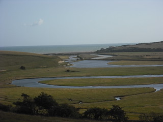
- Go straight over the road, past the green Forestry Commission sign welcoming you to Friston Forest. Go straight ahead up the long flight of steps of the hill in front of you. At the top of the steps proceed straight on along the path for another 70 metres as it swings to the right up to a stone wall where you have a marvellous view over the estuary of the Cuckmere as it meanders its final way down to the sea.
- Go left over the wall past a noticeboard on your right about the Cuckmere Meanders and through the wooden gate. Go straight down the hill towards the river, your direction 245°. In 150 metres go through the kissing gate at the bottom and down on to the A259.
- On your right, set back, you come to the suggested early tea place, Saltmarsh Farmhouse. You can also go to the Exceat Visitors’ Centre to view information about the cliffs and river and look at the shepherd’s hut on the way to the restaurant. There are also public WCs here.
- Coming out after tea on to the A259, cross over the busy road with care to the bus stop (for buses to Seaford) and turn right along this main road. If not stopping for tea until Seaford, you might wish to stop at the icecream van usually parked in the car park, some 40 metres down from the bus stop.
- In 500 metres the road comes to Exceat Bridge crossing the Cuckmere River. Walk across the bridge with the Cuckmere Inn pub straight ahead of you on the far side. Immediately over the bridge turn left through the pub car park. Walk the 90 metres across the car park parallel to the river.
- On the far side there is a wooden swing gate with a yellow arrow on the gatepost next to a wooden fieldgate. Go through the gate, passing a National Trust sign for Chyngton Farm on the left and an information panel on your right. Continue along the path between hedges.
- In 270 metres you come to a wooden swing gate with yellow arrows showing directions ahead and left. Here you have a choice of 2 paths down to the sea, inland, or following the river. There is also a "Welcome to Cuckmere Valley" information panel on your right.
- i) To follow the inland route along the Vanguard Way: Go ahead through the gate, your direction due south initially. Ignoring ways off, follow the path for 750 metres to a gate with a wooden fieldgate to its left. Go through the gate and continue along the path in the same direction as before. In another 800 metres go through a kissing gate to the left of a wooden fieldgate where the path appears to fork and where you can see some cottages on the hillside ahead. Follow the left-hand fork along the edge of the fence to your left. After 150 metres go through another gate and a further 50 metres brings you down on to the beach, point 6 below.
- ii) To walk closer to the river: Turn left due east and follow the path when after 100 metres it turns right. Continue on the embankment path with the main river channel on your left and a stream on your right until you get to the beach. 20 metres before reaching the shingle, go right on a grassy path and continue to the end of the beach, point 6 below.
- [6] You are now at Cuckmere Haven beach. You can have a dip if you are in the mood and the tide is in. There is also a fine view to the left of the shoreline of the white cliffs of the Seven Sisters with, at the far end, the lighthouse on the top of Belle Tout. At this point turn right through a gate going uphill behind the cottages which line the seashore, your direction 260° initially. In 150 metres the car-wide track takes you over a cattle grid.
- Turn left towards a wooden bench you can just see ahead. You are now on the edge of the coastal cliff and you follow the edge of the coastline all the way to Seaford, taking the path parallel to the cliffs but always keeping a safe distance of at least 25 metres from the cliff edge. [!] Note: In 2017 there have been two land slips and the chalk cliff edge remains unstable. Keep well to the right of the cliff edge. After 2km following the coast, the path takes you along the edge of a golf course over to your right and soon starts to descend down the hill towards the town. When you get to the brow of the hill looking down into Seaford, follow one of the paths away from the cliff edge and head down to the beach.
- Walk along the promenade beside the beach. 400 metres along the seafront you come to the Martello Tower which is the Seaford Museum of Local History. There are public toilets next to the Tower.
- In 350 metres by a pavilion on the esplanade turn right down the Causeway, heading away from the seafront, your direction 30°. As you walk down this road you can see the tower of the parish church ahead and to the left.
- At the bottom of the road is a mini-roundabout with the Wellington pub ahead and to the left of the pub a building with white pillars all along its front, supporting a wooden balcony. Cross over the road and go left along the front of this building and then right into Church Street.
- 50 metres up this street you come to a T-junction where you turn left , going up the hill and passing the church. Along Church Street you also pass the Old Plough pub, Trawlers Fish and Chip Restaurant and other restaurants.
- You come to a junction with the A259 at a mini-roundabout with Sutton Park Road to the right and Station Approach Road to the left. Turn left for Seaford Railway Station on your left. Within the small station complex you will find Steamworks mini-pub and bar.