Arundel to Amberley walk
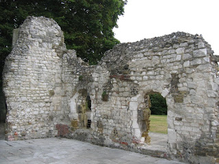
Arundel Castle, its parkland, and the South Downs
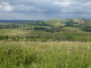
View northwards from Arundel Park
Amberley to Arundel walk
Jul-19 • Saturdaywalker on Flickr
swcwalks book1 walk32 walkicon 48415725721

cathedral of our lady philip howard, arundel
Jul-06 • Bela Struzkova
book1, swcwalks, walk32 5816265377379498306 P

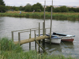
Arundel Park, River Arun & Burpham
| Length | 18.8km (11.7 miles), 5 hours 15 minutes. For the whole outing, including trains, sights and meals, allow at least 10 hours |
|---|---|
| Toughness | 7 out of 10. |
| OS Maps | Explorer OL10 (was 121) or Landranger 197. Arundel, map reference TQ 024 063, is in West Sussex, 4km north of Littlehampton. |
| Features |
This lovely South Downs walk passes through Arundel, which has a very pretty and historic centre, a Cathedral, and a very large and picturesque Castle, and then through the castle's landscaped parkland. Amberley, at the end of the walk, has a pretty riverside tea garden and a recommended pub. The walk starts and ends along the River Arun. It goes up Arundel’s old High Street, lined with ancient buildings, to the Duke of Norfolk’s castle. The Norfolk family have been Roman Catholics for centuries, hence you pass the only church in the UK that is part Catholic and part Protestant (the Catholic part is their chapel, separated off by an iron grille). You pass the impressive Roman Catholic Cathedral (free entry, recommended) then enter the 1,240-acre Arundel Park (the park is closed on March 24th each year, but the public footpaths should remain open on that day). From the Hiorne Tower, you descend to Swanbourne Lake, then go up and through the Park to exit it through a gap in the wall, to walk above the River Arun again. The route leads you to the isolated hamlet of South Stoke, with its unusual church and from there you walk beside the river all the way to the village of Burpham, with its church, and pub – your lunchtime stop. The walk requires a relatively early start from London if you want to be in time for food at the lunchtime pub; the distance to the lunch pub in Burpham from the start of the walk is 5.9 miles, 2.5 hours of walking. The afternoon’s walk, up, over and down the chalky South Downs, makes for a nice contrast to the morning’s walk. There are several stretches that are steep (but with excellent views in compensation) and some of the descents on chalky paths can be slippery in the wet or after recent rain. When coming down off the South Downs towards Amberley, the final leg of the walk, across the south-western section of Amberley Wild Brooks, should not be undertaken in winter or after periods of heavy rain, as your route over the water meadows is likely to be flooded; instead, take the direct route down High Titten (lane) to the railway station and the Bridge Inn. Amberley is a delightful village with many thatched houses, a pub, tea shop and village store, in addition to its castle and church. Next to the railway station is the Amberley Museum and Heritage Centre. |
| Walk Options |
There are several opportunities during the walk to cut it short or embark on a different, shorter walk. Many of these options are described in full in our Arundel Circular and Amberley Circular via Arundel Park walks. To mention a few of the options in outline here. Shortcuts
Short circular walk (with a riverside pub)
In reverse
Longer walk
|
| History |
Arundel Castle was built at the end of the eleventh century by Roger de Montgomery, Earl of Arundel. The castle was damaged in the Civil War (changing hands twice) and was largely rebuilt in ‘idealised Norman’ style by Dukes of Norfolk in the eighteenth and nineteenth centuries. Parts of the castle and its grounds and cafe are open to the public (tel: 01903-882173) in 2023 between 01 April and 31 October, Tuesday to Sunday, Bank Holiday Mondays and all Mondays in August: Gardens 10 am to 5 pm, Castle Keep from 10 am to 4.30 pm, Castle Rooms from 12 am to 5 pm, with last admission 4 pm. Full access ticket (2023) to Castle, grounds and bedrooms is £27.00, which qualifies for a spending voucher; Castle and grounds is £25.00, and for grounds only £ 14.00. For Jousting events (usually in July) the price is £ 29. Hiorne Tower within Arundel Park, is named after architect Francis Hiorne, who was bidding to rebuild much of Arundel Castle at the time - 1797. The then Duke of Norfolk was unimpressed by Mr Hiorne's "folly" and as a consequence he was not awarded the commission. Some historians object to the tower being described as a folly, although in truth it is ! The 50 ft tall triangular structure was built in the Gothic revival style, with three octagonal corner turrets in flint and stone chequer work with pointed and mullioned windows. It was occupied as a residence until 1960 - with a Mr and Mrs Bailey living here for 62 years until their deaths in 1937. The tower had a modest but important practical function in bygone years when the Duke's rifle range in the valley below was in use. Red flags flown from the top of the tower acted as a warning to pedestrians not to venture beyond Swanbourne Lake below the tower whilst shooting was in progress. Today, parts of the tower are used for storage, although the main parts are open to visitors on most days, with closing time around 5pm. Finally, the tower's recent claim to fame was its appearance in an episode of Doctor Who. The lack of labourers after the Black Death in 1349 led to the decay of St Nicholas Parish Church, Arundel, which was rebuilt in 1380. There were no pews, but there were stone seats around the side (hence the expression ‘the weakest go to the walls’). The building became barracks and stables for the parliamentarians during the Civil War – their guns laid siege to the castle from the church tower. In 1969, the then Duke of Norfolk opened up the wall between the Roman Catholic and Protestant parts of the church. For ecumenical special occasions, the iron grille dividing them is opened. The Roman Catholic Cathedral of Our Lady and St Philip Howard in Arundel was completed in 1873. Entry is free. St Philip, thirteenth Earl of Arundel, whose father was beheaded by Queen Elizabeth I, was himself sentenced to death but died in 1595 after eleven years in the Tower of London, aged 39. The eleventh century St Leonard’s Church in the hamlet of South Stoke (population 57) has a thin tower with a ‘frilly cap’, topped by a nineteenth century broach spire with four slatted dormer windows. The church is still lit by candles. Since the last resident Rector left in 1928 the parish has been in the care of the Vicar of Arundel. A Roman pavement was uncovered in the churchyard of St Mary the Virgin Church, Burpham, and parts of the church date from before the Norman Conquest. Amberley Castle and St Michael’s Church, Amberley were both built shortly after the Norman Conquest by Bishop Luffa, using French masons who had been brought over to England to build Chichester Cathedral. The castle, one of three country palaces for the Bishops of Chichester, was considered necessary to defend the Bishops from peasants in revolt and from marauding pirates. Today, the castle is an exclusive hotel. A hundred men once worked at the lime and cement works that now form the Amberley Museum and Heritage Centre (amberleymuseum.co.uk, tel: 01798 831370, highly recommended), next to Amberley railway station. The museum occupies a 36 acre site and is dedicated to the industrial heritage of the south-east, containing a wide range of exhibits, including vintage transport, tools and telecommunications. The museum is also home to a number of resident craftsmen and craftswomen, working in traditional ways. Open to the public from 01 February to 31 October, Wednesday to Sunday, from 10 am to 4.30 pm, and in winter on Wednesday, Saturday and Sunday from 10 am to 4 pm; also February half term week and on all days during West Sussex school holidays. Admission price for 2022 is £ 16.00 with gift aid, plus concessions. Average visit is 4 hours. |
| Travel | Take the train nearest to 9am from Victoria Station to Arundel. Journey time about 1 hr 25 minutes. Trains back from Amberley to Victoria are hourly, with a similar journey time. Buy a day return to Arundel. |
| Lunch | The suggested lunch stop is the George Inn (tel:01903-883131)at Burpham, some 9.5 km into the walk. The pub has a menu of quality main courses and specials, sandwiches (weekdays only) and substantial snacks. Lunch is served between 12 noon and 2.15 pm, Monday to Friday, and from 12 noon until late afternoon on Saturdays and Sundays. Booking is advised during weekdays and is essential at weekends and on Bank Holiday Mondays as the pub is very popular, although in summer it is often possible to find space at an outdoors table. There are also some benches outside the churchyard nearby where you can sit and enjoy a picnic and a pint from the pub. The other picnic spot in Burpham is at the nearby cricket ground. |
| Tea |
Amberley Village
Amberley Station
Arundel
|
| Updates |
No major changes. This edition following partial book check and walk update October 2021. Reverse directions added October 2020 |
| Book |
This walk was originally published in Time Out Country Walks near London volume 1. We now recommend using this online version as the book is dated. The book contained 53 walks, 1 for every week of the year and 1 to spare. Here is our suggested schedule |
|---|---|
| Profile | |
| Help Us! |
After the walk, please leave a comment, it really helps. Thanks! You can also upload photos to the SWC Group on Flickr (upload your photos) and videos to Youtube. This walk's tags are: |
| By Train |
Out (not a train station) Back (not a train station) |
| By Car |
Start BN18 9PH Map Directions Return to the start: Finish BN18 9LT Map Directions Travel to the start: |
| Amazon | |
| Help |
National Rail: 03457 48 49 50 • Traveline (bus times): 0871 200 22 33 (12p/min) • TFL (London) : 0343 222 1234 |
| Version |
Mar-23 Marcus |
| Copyright | © Saturday Walkers Club. All Rights Reserved. No commercial use. No copying. No derivatives. Free with attribution for one time non-commercial use only. www.walkingclub.org.uk/site/license.shtml |


Walk Directions
The main walk
- [1] From platform 2 at Arundel Railway Station go up the steps and cross over the footbridge to exit through the main station building (or through a gate to its right) and immediately turn right onto a signposted pedestrian and cycle route which takes you under the busy A27 road. Head up this tarmac path which joins the main road in some 80 metres opposite the station access road.
- Continue along the road's pavement for some 100 metres until you come to a major roundabout where you fork right, on The Causeway, signposted Arundel Castle.
- In 120 metres [!][2] take the public footpath signposted to the right, your direction 65°. In 60 metres go up concrete steps to come to the River Arun, where you turn left , your direction 325°, along the top of the bank. Arundel Castle is directly ahead of you, on the horizon.
- In 275 metres leave the bank by turning left on a path between wooden fences. In 8 metres you cross a tarmac drive to go between gateposts and across a parking area, your direction 235°. In 40 metres you come to the main road where you turn right.
- Go over Arundel Bridge, cross over a mini-roundabout and go straight on , up the High Street (the ‘no-entry’ road), with the Post Office on your right. In 60 metres you pass Mill Lane on your right-hand side and in 50 metres you pass the War Memorial on your left. You then pass Tarrant Street on your left and in 40 metres you pass Arundel Museum and Heritage Centre on your left.
- Keep on up High Street as it becomes steeper and you pass Maltravers Street on the left, and then the castle gatehouse on your right. The road now veers left uphill and in 20 metres fork right, keeping the castle walls on your right-hand side, heading west, still uphill.
- In 90 metres you pass St Nicholas Parish Church on your right-hand side (worth a look inside). In a further 100 metres, as the road levels out, you pass the entrance to the Roman Catholic Cathedral of Our Lady and St Philip Howard on your left-hand side. In 20 metres you pass St Mary’s Gate Inn on your left.
- The road now swings to the right and downhill, in 125 metres passing St Philip’s Catholic School on your left, at the end of which [3][!] you fork right off the road, on a path across grass, following the wall on your right-hand side, your direction 340°.
- In 70 metres you come to a notice board on your left about Arundel Park, where you keep ahead, now on a tarmac drive. Ignore the fork on your right to Arundel Estate Offices, and keep ahead up the tarmac drive, with the wall on your right-hand side.
- In 150 metres go through the high wooden kissing gate to the left of the main gates into Arundel Park, with a turreted lodge house on your right. Keep ahead on the tarmac estate road, your direction 10° (or along the top of the bank on its right-hand side, if you prefer).
- In 170 metres ignore a road forking to the left and continue ahead. In a further 30 metres, as the road bends to the left, leave it and turn half-right across the grass and head gently uphill towards Hiorne Tower [4] (so marked on the OS map).
- In 150 metres, on reaching the Tower, turn 90° right and head for the footpath post (marked by a yellow arrow and a Monarch Way disc), 40 metres away, on a bearing of 50°. At the post, cross a horse training gallop, from which you can see Swanbourne Lake below, and then continue ahead into light woodland to go down earthen steps, quite steeply, with the fence on your left-hand side, your direction 45°.
- In 30 metres at the bottom of the steps you come down to an earth and chalk track where you turn left to go over a stile, with a fieldgate to its left, your direction 315°. Now continue down this chalky track as it swings to the left, then right. Take care during the wet or after periods of heavy rain, as the chalk can be slippery.
- The track now swings steadily to the right, downhill, with fine views below to the right and after 500 metres down this track, you reach the valley bottom [5]. Cross a major, grassy path junction, with a footpath post on your right and in 10 metres [!] bear left, steeply uphill, your direction 20°.
- In 130 metres you come to a stile and a two-armed footpath sign. Go over the stile and keep straight on (slightly to the left) , your direction now 5°, uphill on a clear path over the grassy open parkland.
- In 400 metres, still climbing, you come to two oak trees and a two-armed footpath sign on your left. Carry straight on (following the direction of the sign) towards the left-hand edge of a coppice ahead, your direction now due north.
- In 280 metres, as the way levels out, cross over a stile amongst a cluster of five oak trees in the coppice and keep ahead towards the left-hand edge of a wood ahead. In 180 metres your path joins a grass and chalk track coming in from behind and to your right, just before a two-armed footpath sign. Keep ahead along the track, your direction 330°, with the wood to your right.
- At the end of the wood on your right, and by a footpath sign, keep ahead over parkland grass, slightly downhill, your direction due north, heading towards a stile. You have fine views of the church in South Stoke on the river to your right (at 85° from you) and three hamlets cum villages lie below you: North Stoke, the closest, on the right, Houghton to its left and in between and behind these, Amberley, at 40° from you.
- In 110 metres cross over the stile, with a wooden fieldgate on its right-hand side) and follow the direction of the footpath sign downhill, on another chalky track that can be slippery in the wet.
- In 225 metres, at the bottom of the track, at a T-junction [6], follow the footpath sign to the right, your direction 110°, on a track, gently downhill.
- In 120 metres, as the track swings to the right and by a two-armed footpath sign, follow the sign left, with a field fence on your right, your direction 55°, on a narrow path which meanders steadily downhill, soon through scrub then light woodland.
- In 225 metres you pass a directional post on your right and continue down, now with the park wall on your right. Pass around a tree in the middle of the path and head more steeply downhill, in 80 metres [!] coming to a tall metal kissing gate in the park wall on your right [!] which you pass through to exit Arundel Park.
- You are now at a bridleway junction [7], with the River Arun some 50 metres ahead and down below you.
- Here you have the first opportunity to take a short cut in your route, by turning left along the bridleway, to follow the river for 2 km to Houghton Bridge.
- But the main walk route is to turn right along the bridleway, with the river down below you, over to your left and with the park wall on your right.
- In 650 metres you come to a wooden fieldgate with a wooden swing gate on its left at 90°. Go through the swing gate and keep ahead, following the direction of the two-armed footpath sign. You now come out into the open, with a large field on your right. Follow the line of the fence on your left, steadily downhill and in 220 metres, at the bottom, your path swings sharply to the right . In a further 35 metres you come to a wooden fieldgate on your left (to the right of a hidden and overgrown stile). Turn left through this fieldgate, to follow the direction of the footpath sign on your left, along a farm track, on a bearing of 120°.
- The track soon heads uphill, with open fields to the right and the river down below, on your left. In 240 metres the track comes out into the open at a junction with a track to your right. Keep ahead, now gently downhill and in 100 metres you cross over a chalky turning circle with an access ahead leading down to a farm barn. Keep ahead, slightly right passing to the right of the farm barn below you to your left.
- In 100 metres you come down to South Stoke Farm yard [!] where you turn right onto a path, your direction 145°, with a wall on your right, following the direction of the footpath post on your right-hand side. (Note: do not take a short cut across the farm yard to the road – the farmer gets cross with walkers who do not follow the footpath.)
- You pass the Gothic-style Chapel Barn on your immediate left. 65 metres along the path you reach a tarmac road, where you turn left, your direction 55°. Pass the farm buildings on your left and in 70 metres at a minor road junction take the left fork , due north. In 60 metres you pass on your right, house No.38 (which used to be an inn) with a post box in the front wall and then you come to the entrance to St Leonard’s Parish Church, South Stoke, well worth a visit. After visiting the church, retrace your steps to the road and continue onwards, now on a gravel car-wide track.
- In 150 metres, just before you come to South Stoke Bridge over the River Arun ignore the stile on your right. [!] ( Unless you plan to do an Arundel Circular walk, in which case cross over this stile and follow the riverbank path back to Arundel, stopping at the Black Rabbit pub for lunch).
- The main route is to cross over the steel bridge. 5 metres beyond its end [!] you have a wooden kissing gate on your left and a stile on your right.
- [!] For a direct, short cut route to Amberley station, go through the kissing gate, to follow the path to North Stoke, then a lane to Houghton Bridge.
- But the main route is to turn right over the stile [8] to follow the River Arun, on the path on top of the riverbank, your initial direction 115°,with the river on your right-hand side and the railway line over to your left.
- Ignore all ways off, as the river bends to the right and in 460 metres you come to a light woodland coppice, a 60 metre muddy section with stiles at either end. The mud can be avoided by dropping down from the riverbank to your left to then walk along the track parallel to the path. At the far, second stile return to the bank as you come back out into the open and continue ahead along the top of the river bank, through bends in the river. In 700 metres cross the railway lines by stiles at either end (with a recently renewed superstructure to the railway bridge over the river on your right). Continue alongside the river.
- In 270 metres you come to a three-armed footpath post on your right. 15 metres further on, cross over a former builder's access road (used to rebuild the railway bridge) and bear right through a metal fieldgate (usually propped open) or if not open cross over the stile to its right and keep ahead, your direction 170°.
- Continue ahead over a grassy meadow with the river to your right and in 300 metres, go through a metal swing gate and [!] fork left [9] on a narrow path that heads uphill, through light woodland, your direction 130°. In 90 metres, at a two-armed footpath sign, you fork left (not right per the sign) your direction now 55°.
- Follow the path uphill between wooden fences, coming out onto a car road by the start of houses, and some 150 metres from the path fork, you come to the George Inn, Burpham , the suggested lunchtime stop. Note: this pub used to be called the George and Dragon Inn - for reasons unknow the "Dragon" was dropped a few years ago.
- Coming out of the pub door, turn right , due north, pass to the left of Burpham House and go through the gateway of St Mary the Virgin Church, which is worth a visit.
- Coming out of the church, go sharp right through the churchyard, your direction 345°, to exit the churchyard through a metal swing gate. Cross a grassy area with young pine trees to come out on to a tarmac road where you turn right, your direction 330°. You have a good view of Arundel Castle, on the horizon over to your left.
- In 400 metres you come to Peppering Farm (so marked on the OS map) and a tarmac road T-junction. Follow the public bridleway sign straight on, your direction 350°, passing barns and sheds on your left-hand side.
- Head downhill, then uphill, on a car-wide track with grass down its middle, initially between hedges, then with a large open field on your left. After 400 metres, the track descends and swings to the right. In 70 metres ignore a stile to the left and in 65 metres, ignore another stile on the left, with a chalk cliff on your right-hand side.
- You are now on a grassy track at the bottom of an escarpment, above you on the right, and with a wire fence on your left and water meadows beyond. In 120 metres you pass under mini-pylons. In a further 350 metres, with a metal fieldgate and stile directly ahead of you, and by a three-armed footpath sign on your right, [!][10] turn right over a stile to go up steps, steeply uphill, on a narrow path, your direction 100°.
- Go up all 244 steps to a stile, which you cross to continue upwards on an earth path which is less steep, and before long begins to level out, now with an open field on your left behind a hedge. Some 135 metres from the end of the steps and the stile you come out on to a bridleway (a flint and chalky car-wide track), with a metal fieldgate on your right.
- Turn left on the track, your direction 20°, along the top of the South Downs. In 600 metres [11], at a crossing of tracks at an angle, and by a three-armed footpath sign, cross over and keep ahead (slightly to the right), your direction 30°, now on a car-wide grassy way, gently uphill.
- In 150 metres, by a post on your left with a yellow and a blue arrow, leave the track [!] to go left on a possibly overgrown footpath, due north, into trees and brush. In 60 metres, by a four-armed footpath sign, cross a bridleway to continue straight on through brush.
- In 30 metres you come out into the open and continue (slightly right) on a grassy, car-wide path, due north, gently uphill, with open fields on your left and a high hedge with blackberry bushes on your right. In 300 metres you come to a four-armed footpath sign on your right-hand side, to cross an earth road and continue ahead (slightly to the left) on an earth road, with grass down its middle, your direction 350°, downhill.
- In 75 metres go through a metal swing gate to the right of a metal fieldgate, and head steadily downhill. In 300 metres, at the bottom of the combe [!], fork right to go due north across grass, over a grass track, in 65 metres going through a wooden swing gate to the left of a metal fieldgate, by a two-armed bridleway sign.
- Turn left, your direction 290°, on a usually very muddy car-wide earth track, which meanders steadily uphill. In 150 metres you come out into the open and continue uphill, your direction north, following a grassy way by a fence on your left. In 210 metres go through a wooden swing gate with a metal fieldgate to its right-hand side, and keep onwards, now more gently uphill, with the fence still on your left and with open fields on your right - now a new vineyard (2021).
- Keep ahead on what is now a track, keeping close to the fence on your left at all times and ignore all ways off. Where you have an option of taking a chalky track to your right (almost parallel to your way) [!] keep to the track closest to the fence on your left, your direction 320°.
- In 475 metres your way merges with a major farm track from behind and on your right-hand side, with a two-armed footpath sign on your left, and in 60 metres your way is joined by a track from behind and on your left-hand side. There is a pond below you, also to your left, and Downs Farm (marked on the OS map) off on the other side of the valley.
- In 50 metres the track swings to the left through a pair of metal fieldgates, then in another 50 metres you go through another pair of metal fieldgates as the South Downs Way joins you from the right [12]. Now keep ahead (left) on the South Downs Way. In 50 metres, as the track swings left towards the farm by a three-armed footpath sign,[!] fork right, your direction 280°, to head downhill, on a narrow path between fences, with the village of Amberley visible below on your right-hand side.
- In 240 metres go through a wooden swing gate. In 50 metres you drop steeply down to a tarmac lane where you go right, your direction 320°. The lane swings to the left and in 100 metres you come to a lane junction [13].
- For the direct route to Amberley Station (recommended when the Amberley Wild Brooks are waterlogged, or if it is getting dark and or you wish to get to the railway station in a hurry), take the left fork , down High Titten (lane). In 600 metres, at the junction with the B 2139 road, turn left, and in 400 metres you come to the access road to the railway station on your left-hand side.
- But continuing on the full walk route which takes you through Amberley village and over the water meadows of Amberley Wild Brooks: at the lane junction take the right-hand fork (Mill Lane), downhill on tarmac road, your initial direction due west.
- In 400 metres you cross the busy B2139 road to go straight on into Amberley Village.
- In 170 metres, having passed a school on your right, you come to Amberley Village Tea Room on your right-hand side (a possible tea stop). In 20 metres ignore the road to your left and keep ahead, gently uphill. In 50 metres you pass the Village Store and Post Office on your right-hand side. In 35 metres you pass the Black Horse pub on your right-hand side (another possible refreshment stop).
- Turn left by the pub along the tarmac road, your direction due west, walking past thatched cottages on both sides. In 100 metres ignore a footpath sign to the right beside The Thatched House (a track which heads north across Amberley Wild Brooks) and keep ahead. In a further 100 metres you pass the thatched Old Place House on your right-hand side and at this T-junction you turn right , your direction west, passing the front of Old Place House.
- In 60 metres you pass the Pottery on your left-hand side. In a further 110 metres you may wish to enter St Michael’s churchyard. Exit the churchyard by the entrance you came in and continue along the tarmac road, now downhill.
- In 80 metres you are below the walls of Amberley Castle. In a further 100 metres continue ahead, now on a footpath below the castle walls on a path between fences, your direction 260°. At the end of the walls above keep ahead along the path, now in the open, in 160 metres going over stiles across the railway lines, to continue onwards, with Bury Church visible ahead.
- In 210 metres go over a stile to the left of a metal fieldgate, and head a quarter left, following the yellow arrow on the footpath post. In 120 metres cross another stile to the left of a metal fieldgate and keep ahead, across water meadows. In a further 130 metres go over a stile and across a stream and head for the raised path beside the River Arun, directly ahead.
- In 150 metres you come to the raised path [14] where you turn left along the top of the riverbank, by a three-armed footpath sign, with the river to your right, your initial direction 220°.
- Keep ahead on the path on top of the bank as it sweeps to the left in a semi-circle. In 550 metres cross a stile and keep ahead. In another 550 metres cross the substantial South Downs Way footbridge [15] and on its far side, turn left along the riverside as the path now swings to the right.
- In 550 metres you come to the B2139 road and go left over the bridge, [!] taking great care as there is no pavement and the narrow road is quite busy. On the far side of the bridge is a lane on your left leading to the Riverside Café, a possible tea stop. Ahead and on your right-hand side is the Bridge Inn, another possible refreshment stop.
- Continue ahead along the road, go under the railway bridge and in 40 metres turn right up the station access road, uphill, passing Amberley Museum and Heritage Centre on your left, with Amberley Railway Station on your right. Cross the footbridge for trains back to London.
In reverse: Amberley to Arundel
- [1] [numbers refer to the map in TO Book 2].
- The start of the walk from Amberley to the village of Burpham follows the directions in Book 2, Walk 22 .
- On arrival at Amberley Railway Station on platform 2, exit the station and turn left down the station access road. In 50 metres cross the busy main road – the B2139 - with care and turn right . Continue along the pavement. In 200 metres, just after Boundary Cottage, the footpath runs behind a hedge.
- In 180 metres cross back over the road and turn right up High Titten . Climb this lane steadily, avoiding all ways off. In some 600 metres, stay on the lane as it bears to the right, at a junction with a road on your left which heads downhill to Amberley Village . Keep ahead, still steadily uphill, in 100 metres passing on your left a footpath heading up into woodland to join the South Downs Way.
- In a further 235 metres, and just before you reach some cylindrical grain silos ahead of you turn left at a two-armed footpath post [2] and head up a path which soon joins a car-wide farm track. In 60 metres go through a double metal fieldgate and head past two sets of farmyard barns – Downs Farm . Keep ahead, bearing right and in 250 metres you pass on your left-hand side a three-armed footpath post. Here swing right on what is now a chalky farm track. [!] Do not be tempted to keep ahead uphill on the South Downs Way .
- In 50 metres pass through a double metal fieldgate and keep ahead, your initial direction 120 degrees, and in another 40 metres pass through a metal swing gate to the right of a double metal fieldgate. You will now keep ahead on this chalky farm track as it winds gently uphill to the left. Ignore a track on your right and keep ahead .
- Some 1.25 km along this track, as you approach a wood ahead of you at the brow of a hill, turn left through a wooden swing gate by a two-armed footpath sign and turn right onto a path. Keep ahead on this narrow path with woodland to your left. In 250 metres you come out at a path junction in a field boundary and turn right , with a hedgerow on your right. Keep ahead on this path.
- In 350 metres you come down to a path and track junction by a three-armed footpath sign where you turn right . In a further 20 metres [!] turn left at another three-armed footpath sign and turn down an enclosed path. Your way ahead is now straight down this bridleway, soon with a new fence on your right and newly planted young trees with vast open fields beyond.
- In 1.35 km you pass on your left a sign welcoming walkers to The Angmering Park and Estate . Keep ahead and in a further 280 metres pass through a wooden gate by a bridleway post [4] on your left to reach a track junction. Here turn sharp right – slightly back on yourself – and head down a chalky track, your direction 290 degrees.
- In 475 metres, having gone down a dip and back up the other side, you reach the bottom of the track at a track junction, by a bridleway sign. Here turn left onto another track, your direction 200 degrees, and keep ahead on this track towards some farm buildings which later come into view.
- In 900 metres pass by on your left-hand side Burpham High Barns and keep ahead along the track. In a further 1 km the track comes out at a road junction. Cross straight over (slightly right) and head up the road into the village of Burpham . In 360 metres at a road T-junction, turn right , uphill, and in a further 100 metres you have to your right The Church of St Mary the Virgin (well worth a visit) and to your left the suggested lunch pub stop – The George .
- We now reverse the directions of Book 1, Walk 32 .
- [Numbers which continue refer to the map in TO Book 1].
- Coming out of the George pub, turn right and at the road opposite the church turn left . Head down an access road, soon passing houses on your left. The road continues as a downhill path between fences in light woodland and some 150 metres from the junction with the George pub you come to a fork in the path, by a two-armed footpath sign. [!] Take the right-hand fork, downhill .
- In 90 metres the woodland path comes down through a metal swing gate and out into a grassy meadow, with a bow in the river Arun over to your left. Keep ahead close to the river over a field which has a tendency to become waterlogged in winter.
- In 300 metres go past a broken stile to the left of a metal fieldgate and bear left , in 15 metres to cross over a former builder’s access road (used to rebuild the railway bridge in 2017). Pass through a (usually) propped open metal fieldgate and keep ahead to soon climb up onto a grassy riverbank path beside the river on your left-hand side.
- In 270 metres cross the railway line by wooden stiles on either side and keep ahead on the riverbank path, through bends left and right in the river. In 700 metres cross a stile to enter a woodland coppice – the route through this light woodland section can be very muddy (the mud can be avoided by dropping down from the path to a track running parallel to and below the path). In 60 metres the woodland path exits over a stile to continue back out in the open again on the riverbank path beside the river.
- Continue through a left-hand bend in the river and in 460 metres the riverbank path ends at a stile [8] which you cross. Ignore the wooden kissing gate opposite (a route to North Stoke and Houghton Bridge) and turn left for 5 metres to cross The South Stoke Bridge , an unattractive steel structure. At the far end of the bridge ignore the stile on your left (which you take for a flat riverside route to Arundel via the Black Rabbit pub) but for the main route keep ahead on a gravel car-wide track, gently uphill, into the hamlet of South Stoke .
- In 150 metres you have to your left the entrance to St Leonards’s Parish Church , part hidden behind trees (worth a visit inside). Continue along the track, now a surfaced lane, past cottages and houses, bearing right at a minor road junction, to come to South Stoke Farm on your right-hand side. Go past the farm entrance and at a signposted bridleway turn right onto a broad grassy way between walls passing on your right the Gothic-style Chapel Barn , which looks like a small primary school. In 65 metres at the end of the wall on your left, by a wooden footpath post, turn left onto a raised track.
- In 100 metres you pass to your right and below a farm barn. Cross a chalky turning circle and continue ahead, bearing left , uphill. In a further 100 metres, at a track junction with a track turning left, keep ahead , now downhill, with an open field to your left behind bush and treeline and the river down below you on your right.
- In 240 metres at the bottom of the track go through a wooden fieldgate by a footpath sign and turn sharp right to go around the edge of a large open field. In 35 metres the path swings to the left and you keep ahead, steadily uphill, with the open field to your left and fence and treeline to your right.
- In 220 metres at the top of the slope go through a wooden swing gate set at 90 degrees to a wooden fieldgate to its left, by a two-armed footpath sign, and enter a woodland track. Head steadily down this undulating track, through bends, with the River Arun down below you to your right. In 250 metres the path veers briefly away from the river and as it swings back you have the solid flint wall up to your left which marks the boundary to Arundel Park.
- In 400 metres the path converges closer with the flint boundary wall [7] and you turn left through the high black metal kissing gate, to enter the grounds of Arundel Park . Once through the gate, turn left quite steeply uphill over uneven ground, passing a tree in the middle of your way.
- In 80 metres you pass a directional signpost and you keep ahead , still uphill, on the narrow path through scrub, with a field fence on your left. In 225 metres the path, having left the scrub to be out in the open, comes up to a path and track junction, by a two-armed footpath post. Here turn right on a broad track which swings to the left.
- In 120 metres at a track junction [6] turn left up a chalky track which can be slippery in the wet. Keep ahead at times quite steeply up this track for some 225 metres. At the top do stop to look back for a fine panoramic view over the way you have just walked from Burpham, with Houghton and Amberley just visible over to your left, then North Stoke, South Stoke, and Burpham in the distance to your right.
- Cross a stile with a wooden fieldgate to its left and keep ahead uphill, over grassy parkland, aiming for the right-hand edge of a wood directly ahead of you, your direction due south. In 110 metres at the edge of the wood, with a footpath sign ahead of you, turn right to follow the edge of the wood around and to the left . Now keep ahead, by another footpath sign, on a path with the wood on your left-hand side.
- In some 100 metres you have on your left-hand side a two-armed footpath sign (which can become partially hidden in the treeline in summer). Here [!] bear right off the path to cross grassy parkland on your right-hand side, downhill. You are now aiming for a coppice with five oak trees ahead of you. In some 180 metres you come to this coppice, which you enter over a stile. Pass through this small coppice to come out into more of Arundel Park’s grassy parkland.
- Your way ahead is now gently downhill on a usually clear path over the parkland's grass, in broad open space with fine views on either side. In some 280 metres you pass on your right two oak trees and keep ahead over the parkland, still downhill.
- In 400 metres you come down to a stile which you cross over. Your path now descends steeply – take care here as it can be slippery. After some 130 metres of steep, meandering descent you come down to a track close to a track junction, in a valley bottom, [5] with a footpath post on your left. Here turn right and in 10 metres take the chalky track which climbs steadily ahead then left of you, ignoring the level way which swings to the left to go around Swanbourne Lake .
- Head up the chalky track, which again can be slippery in the wet. The track swings steadily to the left and in some 500 metres at the top of the track go over a stile with a fieldgate to its right [!] and turn sharp right , steeply up a path with earthen steps, through a woodland strip.
- In 30 metres at the top of the path exit the woodland and cross over a horse training gallop to keep ahead over more grassy parkland. Over to your right is Hiorne Tower [4] should you wish to take a closer look at this unusual structure cum folly.
- Keep ahead over the grass to join the surfaced Estate road directly ahead of you, some 145 metres from the gallops. Turn left along the Estate road and keep ahead along it, ignoring ways off. In some 425 metres you exit Arundel Park on your right-hand side by passing through a tall wooden kissing gate to the right of the Estate’s main gates.
- Head down the access road for some 220 metres, passing on your left the entrance to the Estate’s offices and the access to the Duchesses picturesque cricket ground (where by tradition the year’s touring international cricket team plays the first match of its tour against the Duchesses invitation eleven, a lovely occasion).
- Leave the access road when it comes down to a car road [3] and turn left , soon steadily downhill. You pass on your right the entrance to the Roman Catholic Cathedral of our Lady and St Philip Howard . You continue ahead as the road descends and swings sharply to the right, passing on your left the entrance to Arundel Castle .
- Head down the High Street passing along the way your pub and tea stop options. The suggested stops for tea are the Motte and Bailey Café on your right down the High Street, at No 49, and Belinda’s Tearooms on 13 Tarrant Street, off the High Street to its right just before Motte and Bailey.
- Keep on down the High Street, passing the War Memorial on your right-hand side. At the mini-roundabout keep ahead to cross the Town Bridge over the River Arun . Here to your left are some riverside tea options.
- Keep ahead on the road from the bridge. In some 375 metres you come to a roundabout with a main road, the A27. Turn left to then keep ahead until you come to pedestrian lights at a crossing. Do NOT cross this busy road here but instead a little further on take the signposted pedestrian and cycle tarmac path just to your left which takes you down to an underpass under the road, which you go under to come out beside the entrance to Arundel Railway Station [1] . The platform for trains back to London - Platform 1 - is on your nearside.