Mortimer to Aldermaston and Theale walk
Gentle. A stream, Roman Calleva, and an optional canal side extension.


The Roman town of Calleva
| Length | 15.9km (9.9 miles), 4 hours. For the whole outing, including trains, sights and meals, allow at least 8 hours. |
|---|---|
| Toughness | 3 out of 10. |
| OS Maps | Explorer 159 or Landranger 175. Mortimer, map reference SU 673 641, is in Berkshire, 10km south-west of Reading. Aldermaston is also in Berkshire. Silchester and the Roman town of Calleva are in Hampshire. |
| Features |
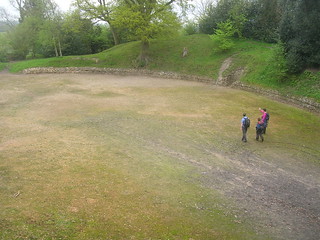
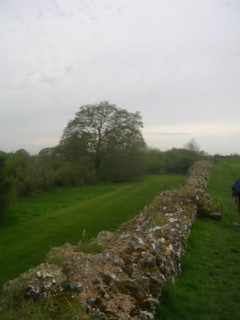
From St Mary's Church in Stratfield Mortimer, the route follows a clear stream - Foundry Brook - eventually to the amphitheatre and the 2.5km of Roman walls surrounding the 107-acre site of the Roman town of Calleva Atrebatum, and the whitewashed twelfth-century church at its entrance. The Roman remains are quite modest - just earthworks, but tea and homemade cakes are sometimes served at the church on weekend afternoons. The lunch stop is at a pub on Silchester Common and the afternoon route is mainly through woods of Scots pine, and commons of gorse and birch trees. Aldermaston, the teatime destination, is reached over the weirs of the River Kennet. |
| Walk Options |
The walk can be extended by nearly four miles to Theale, which has more trains, along an enjoyable canalside path, making a total walk of 22.5km (14 miles). Or for the walker who would like a shorter canalside walk, head west from Aldermaston Wharf and in just under 2 miles you come to Woolhampton Bridge with Midgham railway station nearby. This makes an overall walk of just under 12 miles. There are no options to shorten the walk, other than taking a taxi from the lunchtime pub back to Mortimer railway station. The irregular bus service which used to operate from Silchester to Mortimer or Reading does not appear to be in service on weekdays (Summer 2023). |
| History |
The layout of the Roman town of Calleva Atrebatum has survived intact, having been completely abandoned when the Romans withdrew from Britain (the Saxons hated walled towns). However, all the buildings, carefully excavated, have now been reburied to protect them from vandals and the elements. Only the town walls and the amphitheatre are visible. The amphitheatre was built in about 50AD, with space for up to perhaps 9,000 spectators. It would have been used for public executions and shows with wild animals, but only sparingly for gladiatorial contests, since gladiators, dead or alive, were expensive. The town walls required some 160,000 wagon-loads of flint and bonding stones, and were built about 260AD as part of a general move to protect the Roman Empire from mounting unrest. Many of the exhibits from Calleva are on display in Reading Museum. The tiny Calleva Museum, half a kilometre beyond the site, closed in 2006. The earliest part of St Mary the Virgin Church, Silchester, dates from about 1125. The walls were built with reused Roman bricks. There are two Roman temples underneath the church and graveyard. It has been suggested that John Bluett may have contributed to the building of the church, as the price of escaping a vow to join the crusades. Records show that the church had half a dozen rectors in 1349. Most of them were probably killed by the plague, although one was removed for 'trespass of vert' (taking timber from Pamber Forest). |
| Travel |
Take the train nearest to 10am from Paddington Station to Mortimer, changing at Reading. Journey time 45-50 minutes. Trains back from Aldermaston, changing at Reading for Paddington, are hourly (every two hours on Sundays). Journey time about 1 hour. On the extended walk, Theale has twice as many trains, including (on Mon–Sat) an hourly direct service to Paddington. Buy a day return to Mortimer. In practice this is usually accepted on the return journey, but you might be required to buy a single from Aldermaston (or Theale) to Reading. Senior walkers who hold London Councils Freedom Passes can use their passes on TFL Rail - Elizabeth Line - trains from Paddington as far as Reading. The only tickets you require are singles from Reading to Mortimer, and Aldermaston to Reading. This is not a good walk for drivers, as the two stations are on different lines. You could do it by changing at Reading West, but you might have a long wait for the connection. |
| Lunch | The suggested lunch stop is the Calleva Arms, a Fuller's pub, (tel. 0118 970 0305) on Silchester Common, some 6.5 km into the walk. Lunch is served 12noon to 2.30pm Tuesday to Saturday, and 12noon to 4pm on Sunday (The kitchen is closed on Mondays although the pub is open). Food is locally sourced and the menu is seasonal, with daily specials plus pub classics. The pub is walker friendly although staff appreciate having advance warning of groups, so if there are more than 4 of you wishing to dine please 'phone ahead. |
| Tea |
The suggested tea place is the tea room at the Kennet & Avon Canal Trust Information Centre (tel. 0118 971 2868) at Aldermaston Wharf; it is usually open until 6pm (but is closed om Mondays). It may close earlier in winter. It serves real tea and has a good selection of cakes and snacks. The Butt Inn in Aldermaston (tel. 0118 971 2129) is open (Summer 2023) seven days a week from 12noon, with food served all day. There is an excellent pub The Rowbarge Inn next door to Midgham railway station for those ending the walk at Woolhampton Bridge. For those on the longer canalside walk, to Theale, you have the Crown Inn beyond the railway station for a tea stop. It is possible to visit one of the buffets on the platform at Reading Station while waiting for a connection on the return journey. |
| Updates |
No major changes. [Pre 2011 edition] Use the website version. Route across Padworth Common reinstated. This edition September 2021. Pub updates August 2023. |
| Book |
This walk was originally published in Time Out Country Walks near London volume 1. We now recommend using this online version as the book is dated. The book contained 53 walks, 1 for every week of the year and 1 to spare. Here is our suggested schedule |
|---|---|
| Profile | |
| Help Us! |
After the walk, please leave a comment, it really helps. Thanks! You can also upload photos to the SWC Group on Flickr (upload your photos) and videos to Youtube. This walk's tags are: |
| By Train |
Out (not a train station) Back (not a train station) |
| By Car |
Start RG7 3NY Map Directions Return to the start: Finish RG7 4LB Map Directions Travel to the start: |
| Amazon | |
| Help |
National Rail: 03457 48 49 50 • Traveline (bus times): 0871 200 22 33 (12p/min) • TFL (London) : 0343 222 1234 |
| Version |
Aug-23 Marcus |
| Copyright | © Saturday Walkers Club. All Rights Reserved. No commercial use. No copying. No derivatives. Free with attribution for one time non-commercial use only. www.walkingclub.org.uk/site/license.shtml |


Walk Directions
- Coming off the London train on platform 1 at Mortimer Railway Station go over the footbridge to exit the station. Turn right and in 50 metres, at a junction (where to go right takes you over the railway bridge), go left, your direction 315°. In 70 metres follow the road over Foundry Brook and bear left at roundabout, to head up towards the church.
- In 70 metres you pass the Cinnamon Tree Indian restaurant on your right-hand side. In 165 metres, as the road swings to the right, by a two-armed byway sign, turn left onto a gravel drive, your direction 210°.
- In 75 metres you pass the lychgate entrance to St Mary’s Church, Stratfield Mortimer (probably locked), on your right-hand side. In 25 metres you cross Foundry Brook again on a bridge with brick headwalls and go straight on, with the tarmac drive to Ladyfield House on your right.
- In 35 metres go through a gap in the fence (with a metal fieldgate, off its hinges, to its left-hand side) and turn right , following a yellow arrow footpath sign, your direction 235°, with the field fence – and soon the banks of the brook – on your right-hand side and an open field on your left. Stay on the path following the yellow arrow signs.
- In 400 metres, as you come up to a field boundary, turn right and cross the brook by a footbridge with metal railings and then immediately go left on the other side, now on a path with the brook on your left-hand side and an open field on your right. In 200 metres, just before you pass through a field boundary, you pass the remnants of a wooden platform bridge on your left.
- Keep ahead and in 230 metres turn left through a metal swing gate (with footpath markers on both side), your initial direction south, then follow the path along the left-hand side of the field by the edge of the brook, on a grassy way. In 365 metres go over a wooden plank bridge with wooden handrails and metal swing gates at either end.
- In 100 metres [!] do not go through a gate on your left, but bear right , still with the brook on your left-hand side, and still on a grassy way, your direction 310°. Follow the path as it curves gradually to the right, following the sweep of the brook for 320 metres. Go through a metal kissing gate in the far corner of the field and onto a path through a copse. In 35 metres you come to a minor tarmac road [2] where you turn left , over a bridge, your direction 230°.
- In 400 metres ignore another minor road to the right and keep straight on, past Brocas Lands Farm (as marked on the OS map).
- In 200 metres, as the tarmac road veers to the left, go straight on , passing to the left of a rusty metal barrier and onto an earth road between hedges, your direction 250°. In 200 metres, where this earth road swings to the left, follow the footpath sign through a field boundary and head straight across a large field towards pylons, your direction 275°. [!] Note If this field is in crop or has recently been ploughed up, you might prefer to walk along its boundaries, left first for 80 metres, then right for 400 metres, to then turn left through the metal kissing gate in the hedge mentioned in the paragraph below.
- Heading across the large field, in 450 metres, before going under the pylon cables, turn left towards a metal kissing gate in the hedge, 55 metres away, due south. Go through this gate and head downhill towards a gate in the valley (which may initially be obscured by crops), your direction 190°. (You are heading towards the left of a timber-framed thatched house on the hillside opposite.) In 145 metres you pass under the pylons.
- In 80 metres go on a three-plank bridge over a stream and through a wooden swing gate on its far side. Now head up a grassy field in the same direction, aiming about 100 metres to the left of the timber-framed house.
- In 175 metres, [!] leave the field through a metal kissing gate on your left-hand side, go down four earthen steps and rejoin the earth road you left earlier, but now narrower with bushes on both sides. Turn right, uphill , your direction 205°. (If you miss this exit, continue up the left-hand side of the field towards fieldgates which you will have to climb over to rejoin the earth road).
- In 85 metres, the road widens as you pass on your right-hand side the entrance driveway to the thatched house (The Mount). Keep forward and in 90 metres, although your onward route is straight on, joining a tarmac road, detour right on Wall Lane, your direction 340°, and immediately go through the wooden kissing gate on your right-hand side, to visit the Calleva Amphitheatre (next to The Mount).
- Retrace your steps and continue on the tarmac road you had just joined, southwards. In 100 metres ignore a road to the left and carry straight on, your direction 215°, on Church Lane. In 80 metres you come to the Roman Walls of Calleva and a pond on your right-hand side. To the right is the entrance to St Mary the Virgin Church, Silchester . [3]. Before visiting the church, you might like to go up to the Roman walls to read an information panel about the history of the site.
- Coming out of the church, turn left and then left again to head south-west on a path through the churchyard, leaving it through a wooden swing gate. Veer left to continue on a path along the top of the Roman walls.
- In 85 metres go down steps, and then up steps on the other side, to contine along the top of the wall.
- You could continue along the top of the walls for the next 1km to the West Gate, but the suggested route is to come down at the next but one gap (after 300 metres),just before the walls swing to the right, and continue below them. On this route there are information panels about the South Gate and the earlier Iron Age Settlement (whose ramparts are visible in the field on your left after a further 300 metres). For the final 350 metres the path winds through woodland, still with the Roman walls on your right and now a wide ditch down on your left. Eventually you go through a wooden kissing gate at the site of the West Gate.
- Turn left here and go through a wooden swing gate on to a wide path signposted to Silchester Village, your direction 285°, with a hedge on the left and fence on your right (ignoring the wooden kissing gate to your left).
- In 135 metres ignore a wooden kissing gate on your right-hand side. In a further 200 metres, continue through a gap to the side of a metal fieldgate. In a further 350 metres you go past a small green wooden hut, which once housed the Calleva Museum. Continue ahead across a tarmac road and along a gravel track.
- In 60 metres you come to another tarmac road and cross over it to continue on a path. In a further 120 metres, you come to a gravel path, with Silchester Church of England Primary School on your right-hand side. Turn left and in 20 metres keep left your direction 190°, and cross Silchester Common , laid out with sports pitches. In 250 metres, at the far side of the Common, you reach the Calleva Arms, the suggested lunchtime stop.
- After lunch, retrace your steps across the Common, your direction due north from the pub. You pass a pavilion on your left-hand side. Turn left onto the car park beyond the pavilion and take the exit at the far end leading into a copse (ignore a turning left into playing fields) and in 30 metres you are back at Silchester Church of England Primary School. Turn left , with the school fence on your right-hand side, your direction due west.
- In 30 metres, at the end of the school fence, do not take the forest track to the right of the fence, but keep ahead on a more substantial bridleway, your direction 265°. In less than 100 metres [!] fork right onto a faint path, into a landscape of gorse and silver birch, your direction 280°. In 80 metres your way is joined by another path from behind, on your left-hand side. Continue forward, your direction now 300°.
- In 100 metres, you come to a tarmac road. Cross the road and continue on an earth and gravel car-wide track, past a wooden fieldgate, into Aldermaston Soke Woods (as marked on the OS map), your direction 5°. Heather Brae House is on your right-hand side. Go straight on through these woods, mainly of Scots pine, ignoring all ways off. The route undulates but is as straight as an arrow through the woods. In winter the track might develop puddles but it is mostly free from mud.
- In 1.6km [4], as the track swings to the right, keep ahead and pass to the right of a wooden fieldgate to come out onto a tarmac road.
- The original route continued ahead for 750 metres across what was Burnt Common and then Padworth Common, but much of this area has been lost to gravel workings. The diversion around these workings was removed from these Directions for a while as the paths had become overgrown. The route has now been reinstated, as an alternative to the simpler road route below, although at certain times of year the paths can still be overgrown. The route: Cross over the road and turn left down its verge. Although the footpath running parallel to the road, some 10 metres to the right, beyond the treeline, is still there, it is best avoided as it is overgrown most times of the year. Continue down the road for 450 metres until - some 15 metres before you come to a property called "Windy Whistles" - [!] turn right at a wooden finger footpath sign, to pass through a new fieldgate, then go over a stile onto a car wide track, through light woodland, your direction due north. In 280 metres, at the end of the track, turn right along the fenceline on your right, following yellow arrows, your direction now 60° with treeline to your left, and Burnt Common to your right. Keep ahead for some 100 metres, before you dog-leg left then right, to continue along a cleared, raised woodland path [!] Take Care : your footbed is covered in rabbit burrows and holes. In 250 metres you go under pylons, between pylon posts, and in 20 metres, at a minor cross paths, by a marker post with yellow disc, you turn left and in 5 metres turn right onto a minor path, over the Common, your direction 60°. In a further 200 metres, at a path junction, with a three-plank bridge to your right, and by a marker post with yellow disc, take the left path , your direction due north. In 120 metres keep ahead at a minor cross paths and in 70 metres, with Birch Cottage ahead and to your right, bear left through light woodland and in 50 metres you come out onto a busy road. Cross over to the bus stop and turn left, to rejoin the Road Route at the bridleway turning right to "The Croft".
- The Road Route
- Turn left on to the road, your direction 265°. In 650 metres, with 50 mph signs to left and right, turn right into Chapel Lane. Walk up this residential road for 200 metres to reach a road with a red post box on your right.
- Turn right into this busier road, your direction 40°. In 300 metres you pass a (please drive carefully through) Padworth Common sign on your left-hand sign. In a further 100 metres (just before a 50 mph sign in the verge on your right), turn half-right past a metal barrier on to Padworth Common and take the signposted public footpath to your left, your direction 60°.
- In 10 metres ignore the permisive path to your left and keep ahead on a grassy way for 500 metres, ignoring ways off, until you come out onto the drive of Birch Cottage, with the cottage on your right-hand side. Here you turn left along the cottage's driveway to reach the busy road again, which you cross and then turn left along its verge, your direction 250°.
- In 65 metres, by another 50 mph sign, and just past a bus stop, [5] you come to an entrance to a property called ‘The Croft’. Here follow the bridleway sign and turn right , your direction 350°, along the earth and gravel access road. The Original route continues here .
- In 50 metres ignore a turn to the left (to The Croft, House & Stables). In a further 80 metres you pass on your right the thatched Yew Tree Cottage. In 300 metres, with a pond on your left-hand side, keep left, avoiding a driveway ahead. In 35 metres you pass The Croft Cottage on your left-hand side and continue straight on. In 45 metres veer right with the main path, your direction 345°, keeping a hedge on the right. In 70 metres the path descends and enters woodland. You head down to a dip (often muddy) and up the other side.
- After 100 metres uphill you go through low wooden posts with tops painted white. In a further 100 metres, at a path junction, take the left-hand path, to follow a blue arrow on a post, your direction 320°. In 30 metres you have a high steel and plastic coated wire mesh fence, coloured green, on your right-hand side, guarding a buried BP petrol depot.
- In 340 metres you come down to a tarmac road where you turn left your direction 235°, and head uphill. In 65 metres you pass the entrance drive to the Jubilee Day Nursery on your left-hand side. The path along the top of the bank beside the wire mesh fence to your right is marked "Private - for the Schools' use Only".
- In 240 metres up this road [6], as the road bends left, turn right on to the gravel drive to Upper Lodge Farm, your direction 345° (heading almost back on yourself). In 60 metres, as the drive swings to the left, keep ahead through a metal fieldgate onto a public footpath, your direction due north, with bushes on both sides and light woodland to your right.
- In 300 metres go through a wooden fieldgate to come out onto a tarmac road, opposite Padworth College. Turn left on this road, your direction 225°.
- In 80 metres turn right onto a gravel road, a signposted restricted byway to Padworth Church , your direction 315°. In 80 metres, in front of the war memorial with the lychgate to the church behind, follow a path to the left , your direction 280°.
- In 50 metres you come to a tarmac farm road where you turn right and continue forward with fields on both sides, your direction 300°. In 60 metres, by a two-armed footpath sign turn left, your direction 250°, towards five small concrete mushrooms. By these mushrooms, with horse stables over to your left, turn right onto a signposted footpath, along an earth and gravel track, your direction 335°.
- In 65 metres go through a metal fieldgate (with a broken stile on its left-hand side) and in 20 metres go through another metal fieldgate, to come out into a potentially muddy, horse-churned up field, with an elecric stock-control fence on your right-hand side. Head down this field, following the fence line and in 190 metres, at the bottom of the field, you go through a new fieldgate and bear left over the next field, your direction 290°.
- In 210 metres, in the left-hand corner of this field, with a stream to your left, pass through a metal gate and go over a narrow bridge with a wooden handrail and continue onwards across the next field, planted with tree saplings, your direction 295°. In 160 metres, cross a track and by a four-armed footpath sign, go through a wooden swing gate onto a wooden bridge with wooden handrails over a stream and keep straight on, between low post and mesh fences.
- In 100 metres go through a gap in a hedgerow (wooden swing gate here missing September 2021) and in 20 metres cross a concrete bridge with metal handrails over River Kennet Weir. You then cross several other bridges in quick succession (passing a notice about the Salmon Pass Project, which allows fish to get past the weirs) and continue on a path between fencing.
- You come out onto an earth and gravel car road, by a three-armed footpath sign where you turn left , your direction 310°. In 400 metres you pass the Rudolf Steiner Alder Bridge Centre on your right-hand side. In 130 metres you come to a lock and the main road.
- At this point you have five choices. You can stop for tea at a pub, go directly to Aldermaston Station, stop at the Kennet & Avon Canal Trust’s Information Centre for tea, or continue past it along the canal for a further 6.5km (4 miles) to finish your walk in Theale, or take the shorter 2 mile canalside walk to finish your walk at Woolhampton Bridge (for Midgham station).
- If going to the Butt Inn for tea (now open from 12noon, Monday to Sunday, food served all day), you go left, your direction 210°, coming to the pub in 120 metres. Afterwards, retrace your steps to this point. If heading for Woolhampton Bridge along the canal, cross over the road and continue ahead along the canal.
- Turn right over the bridge over the canal, your direction 355°
- If going to Aldermaston Station, once over the bridge at the first junction turn left onto Station Road, your direction 320°. In 60 metres fork right, signposted Aldermaston Station. In 120 metres you need to cross over the footbridge to platform 1 for trains to Reading (where you can get a cup of tea while changing trains) and onwards back to London.
- If going to the Canal Trust’s Tea Room or if continuing along the canal to Theale,turn right on the path to the left of the canal, signposted to Padworth Bridge. In 80 metres you reach the Trust’s Information Centre, which has a Tea Room. After tea, retrace your steps for Aldermaston Station, or continue straight on for Theale.
- After 2.5km on the towpath on the northern side of the canal you reach Ufton Bridge where you swap to the southern side of the canal.
- Thence you continue along the towpath or paths across fields beside the canal for another 3.5km passing a number of locks, including Sulhamstead swing bridge and lock.
- When you reach Sheffield Bottom swing bridge , turn left over the bridge into Station Road. [!] Do not overshoot: there are some white cottages immediately in front of you when you reach this bridge.
- Proceed down Station Road. Theale Station is over the bridge on your right.
- If time permits a tea stop, go past the station and on over the bridge, over a roundabout and underneath the A4 until you reach the Crown Inn pub, or use the convenience store almost opposite (about 400 metres from the station).