Gerrards Cross to Cookham walk
Bulstrode Park and Burnham Beeches woods, the Thames, and Stanley Spencer

The Jolly Woodman
Gerrards Cross to Cookham walk
Mar-16 • Saturdaywalker on Flickr
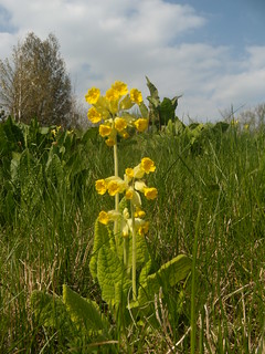
book1 walkicon swcwalks walk40 25733870390
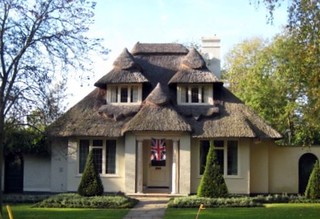
Thatched Cottage With Union Jacket
Time Out walk Gerrards Cross to Cookham.
Oct-07 • msganching on Flickr
house building english topiary walks country cottage unionjack thatched swc swcwalks tocw140 1679316692

Bulstrode Park, Burnham Beeches & Spencer
| Length |
15.7km (9.8 miles), 4 hours 30 minutes. For the whole outing, including trains, sights and meals, allow 7 hours 30 minutes. |
|---|---|
| Toughness |
2 out of 10 (more in winter when muddy). 160 metres of ascent. |
| OS Maps |
Explorer 172 or Landrangers 176 & 175. Gerrards Cross, map reference TQ 002 887, is in Buckinghamshire, 9km north of Slough and 12km east of Cookham, which is in Berkshire. |
| Features |
Near the start, this walk crosses Bulstrode Park and from there, past woods and lakes to a cratered moonscape where the route crosses the M40. Then it goes through the Hedgerley Green Nature Reserve to the church at Hedgerley, and on through Egypt Wood and Burnham Beeches to a pub in Littleworth Common. 8.8km (5.5 miles) of this walk is covered before lunch. In the afternoon, there are more woods and fringes of woods, with an optional detour to the hilltop Church of St Nicholas in Hedsor for a fine view over the Thames Valley and across to a late eighteenth-century folly, a ruined castle. The walk ends alongside the Thames, going over Cookham Bridge to Cookham Church, the Stanley Spencer Gallery and tea and then across the National Trust’s Cookham Moor to Cookham Station. A good time of year to go on this walk is early November when leaf colour in the many beech woods should be at its best. Later, when winter sets in, many of the bridleways can be muddy. |
| Walk Options |
In autumn you can take a detour into Burnham Beeches to enjoy the leaf colour in these woods - directions are given in the main Directions. This adds approximately 1 km to the morning leg of your walk. There are no convenient bus services on the route but you could get a taxi from the lunch pub. To lengthen the walk, you can either continue the walk from Cookham into Marlow, along the Thames Path, starting on the southern bank of the Thames and crossing over to its northern bank at Bourne End, to add 3.5 miles to the walk, or you can head along the Thames Path in the other direction, into Maidenhead, to add some 4 miles to the main walk. |
| History |
The 400 acres of Bulstrode Park were bought in 1686 by Judge Jeffreys who built a house here. It was confiscated when he was sent to the Tower of London. The present manor was completed by the twelfth Duke of Somerset in 1870. Since 1963 it has been the headquarters for the missionaries and admin staff of the Worldwide Evangelization Crusade. Egypt Wood is thought to be so called because it was an oft-used encampment for gypsies prior to 1880 (the name ‘gypsy’ derives from ‘Egyptian’, although gypsies probably originate from India). Since 1880 Egypt Wood (which is a part of Burnham Beeches) has been owned and managed by the Corporation of London. The Church of St Nicholas was mentioned in land records in 1218 and is unusual in that it is entirely set within the grounds of the landowner, Lady Wantner, with the only right of access being for walkers. The church is open on Sunday afternoons in June, July and August. Cookham was inhabited by ancient Britons, Romans and Saxons. In the Domesday Book it is listed as containing ‘32 villagers, 21 cottagers, 4 slaves, 2 mills, 2 fisheries and woodland at 100 pigs’. In 1140 a Norman church was built on the site of Holy Trinity Church, Cookham. The north wall of the church is built of chalk blocks, probably quarried at Cookham. The artist Sir Stanley Spencer (1891–1959) lived in Cookham and there is a memorial stone to him in the graveyard. Spencer was born in a Victorian semi-detached house in Cookham High Street and he attended services at the Wesleyan Chapel in the High Street, which is now the Stanley Spencer Gallery (tel 01628 471 885) open April–October every day 10.30am–4.30pm, Nov–March Thurs–Sun only 11am–4.30pm). The admission fee (2023) for adults is £7.00, concessions available. |
| Travel |
Take the train nearest to 10.15am from Marylebone Station to Gerrards Cross. Journey time 21-30 minutes. Trains back from Cookham to Paddington are hourly, changing at Maidenhead. Journey time just over an hour. As the two stations are on different lines you cannot get a return ticket for the full walk. Instead, either:
For the same reason, this walk is not good for car travel. You can travel back from Cookham back to Gerrards Cross via 2 buses, #37 to Loudwater, then #740 to Gerrads Cross, a 10 min walk from the station - check Travelline South East (link below). |
| Lunch |
For an early lunch stop if you have started out late or for a morning coffee the White Horse (tel 01753 643 225) at Hedgerley, some 5.8 km into the walk, is open from 11am on weekdays and from noon on Sundays, serving food from midday until 2-30pm. This pub specialises in real ale, of which there is an extensive selection, and bottled and draught ciders, making it a popular watering hole for the discerning drinker. The suggested lunchtime stop is the Jolly Woodman pub (tel 01753 644 350) in Littleworth Road, Littleworth Common, some 8.8 km into the walk, which has a good menu and quick service. Summer 2023, lunch is served from midday to 2.30pm daily (Sunday to 4pm). Groups of more than six people should phone to book as it gets busy, particularly on Sundays. A more than acceptable alternative, and cosier than the Jolly Woodman, on the eastern side of Littleworth Common, is the Blackwood Arms (tel 01753 645 672), some 8.7 km into the walk, a homely, walker-friendly country pub, which serves a good selection of light meals, sandwiches, pub classics and seasonal chef specials and Sunday roasts at lunchtime. As of Summer 2023, food is served Tuesday to Friday from midday to 2pm; on Saturday all day (12 noon until 9pm) and on Sunday from midday to 5pm (closed on Mondays except Bank Holiday Mondays when food is served from 12 noon until 5pm). Booking ahead is advisable on weekdays and essential at weekends as this pub is very popular. |
| Tea |
The suggested stop for tea in Cookham High Street is Tea Pot Tea Room (tel 01628 529 514), next door to a tea room which used to be called Infusions. Other options are the seventeenth-century hostelry, the Kings Arms (tel 01628 530 667), open daily until at least 9pm (serves food from noon) and the Bel and the Dragon pub (tel 01628 521 263), both also in the High Street. In addition, there are two pubs which you pass on your way to the railway station, and the Countrystore shop opposite the station. On the western side of the level crossing you will find a Costa Coffee with a pleasant indoor seating area if not using for takeaways. |
| Updates |
No major changes since TO Book published 2011. Route change in afternoon using new section of Beeches Way avoids road walking. This edition - Book check and walk update - November 2023. |
| Book |
This walk was originally published in Time Out Country Walks near London volume 1. We now recommend using this online version as the book is dated. The book contained 53 walks, 1 for every week of the year and 1 to spare. Here is our suggested schedule |
|---|---|
| Profile | |
| Help Us! |
After the walk, please leave a comment, it really helps. Thanks! You can also upload photos to the SWC Group on Flickr (upload your photos) and videos to Youtube. This walk's tags are: |
| By Train |
The out and back routes are with different train companies - check the ticket advice. Out (not a train station) Back (not a train station) |
| By Car |
It is not easy to return to the start by train, as the stations are on different rail lines. Start SL9 8PP Map Directions Return to the start: Finish SL6 9BP Map Directions Travel to the start: |
| Amazon | |
| Help |
National Rail: 03457 48 49 50 • Traveline (bus times): 0871 200 22 33 (12p/min) • TFL (London) : 0343 222 1234 |
| Version |
Nov-23 Marcus |
| Copyright | © Saturday Walkers Club. All Rights Reserved. No commercial use. No copying. No derivatives. Free with attribution for one time non-commercial use only. www.walkingclub.org.uk/site/license.shtml |


Walk Directions
- [1] Coming off platform 1 at Gerrards Cross Railway Station go over the footbridge to exit the station building. Cross the pedestrian crossing outside the building and go left uphill on a tarmac path, your direction 320°.
- In 75 metres go straight on, now on the pavement of a tarmac road, walking parallel to the station car park down below. In a further 140 metres, where this road veers sharply to the right and there is a car park on your left, carry straight on, along a narrow tarmac footpath, your direction 305°.
- In 210 metres turn left to go on a footbridge back over the railway lines. On the far side keep ahead on a path between wooden panel fences. In 70 metres you come out onto a bend in a road (Layters Way) where you turn right, passing Cedar House on your right-hand side. In 75 metres bear left with this road, downhill, which in a further 140 metres reaches a T-junction.
- Cross this road and pick up a signposted footpath opposite, to go along the right-hand edge of a wood, with a fence on your right, your direction 260°. In 200 metres exit the wood up concrete steps onto the A40 road. Cross the road with care and turn left for 25 metres, then turn right onto a path (by a green footpath signpost) between concrete posts, down concrete steps and between wooden fences, your direction 220°.
- In 110 metres you reach a gravelled road opposite Main Court House. Turn right, heading towards the park, your direction 255°.
- In 30 metres go through a metal kissing gate by a two-armed footpath sign and yellow path arrows to enter Bulstrode Park . In winter the first 25 metres of your otherwise grassy way can be very muddy. Follow a wide grass path straight on, ignoring the grass path to your left, your initial direction 255°. You have a new post and mesh fence on your right as you head slightly uphill and gradually veer to the right. Bulstrode Manor is just visible behind trees on the hillock to the left in the distance. After 600 metres, as you reach the top of the hill, continue on an earth then rough tarmac track in the same direction, now veering slightly to the left.
- In 150 metres go through a wooden kissing gate to the right of a pair of metal fieldgates. Here turn right onto a gravel car road. In 20 metres you cross [2] the entrance driveway to Bulstrode Manor and go straight on along a tarmac road. Note: as of November 2023 major building works are still taking place to the Manor House.
- In 35 metres pass to the side of a car barrier. In a further 15 metres, just after a left-hand turning, fork left between wooden posts, onto a path with a fence to your right-hand side, following yellow arrows, your initial direction 280°. In 225 metres this path comes to a T-junction at the edge of a wood. Turn left, your initial direction 255°.
- In 150 metres you pass a lake on your right-hand side. Soon the path re-enters a wooded area, with the lake still to your right. In a further 130 metres you come to the end of the lake to your right. Keep ahead on the path through the wood. In 35 metres, at a fork in the path, take the right fork , your direction now west, and continue through light woodland.
- In 80 metres exit the wood and come out into open land with scub and bushes. Pass under pylons on a clear path which swings to the right as a grassy path joins from the left. In 20 metres bear left with a fenceline now on your right. You pass two metal fieldgates on your right, 10 metres apart as you head towards traffic noise. In 100 metres, go through a metal kissing gate to the left of a metal barrier and head down a flight of concrete steps to a tarmac road, where you turn right, your direction 315°. In 70 metres you pass Moat Farm on your right-hand side and continue on the road which bears left, slightly uphill, onto a bridge crossing the M40.
- Immediately after crossing the bridge, [!] go over a stile on your left and follow the signposted footpath, your initial direction 100°, down a slope and half-right, your direction 145°, into a small grassy field.
- You now continue ahead over this field for 55 metres until you reach a fence at the end of the field, before turning right on a car-wide grassy way, your direction 195 °; which soon joins a gravel access road, or you can take a new path cut diagonally (right) over the field, in 75 metres connecting with the gravel access road joining from the left. Keep ahead on the gravel access road and pass a terrace of houses (Moat Farm Cottages). In a further 60 metres at a T-junction with a tarmac lane turn left, your direction 100°.
- In 75 metres, at the Circular Walk footpath sign in a grassy triangle opposite Bulstrode House, turn right on an earth car-wide road, your direction 220°, with ponds to your left and right. This is the picturesque hamlet of Hedgerley Green , a nature reserve. Walk through the hamlet and in 200 metres, when the road bends left towards Sherley Close, leave it to carry straight on along a car-wide, tree-lined bridleway, following a blue arrow on a post, your direction 230°.
- In 500 metres ignore a wooden kissing gate off to the right as the bridleway veers to the left , heading downhill. In a further 200 metres, you come to a church on your left-hand side, St Mary the Virgin, Hedgerley, which is likely to be locked. Bend right with the path, which is now tarmacked.
- In 85 metres the path comes down to a road, Village Lane, with a large beech tree directly ahead of you, and with the White Horse pub on your right. Turn left along Village Lane, following the circular walk sign, your direction 195 °, and go past Old School Cottage on your left-hand side.
- In 80 metres you pass a pond on the left and Hedgerley’s ‘Buckinghamshire Best Kept Village’ sign on the right. In a further 70 metres turn right [3] onto Kiln Lane.
- In 25 metres you pass Hedgerley Memorial Hall on your right. [!] Note: the first 150 metres along this road is subject to flooding after prolonged periods of rain. In 200 metres [!] turn left through a wooden barrier onto a footpath signposted Circular Walk, uphill, your direction 240°. In 30 metres go through a wooden deer protection gate and continue on the path uphill through a wood. In a further 300 metres go through a similar gate and bear left between fences (chestnut palings on your left, plastic coated wire mesh fence on your right), your direction 190°. In 75 metres you come to a wooden close-boarded fence on your left, with the mesh fence still on your right as the path veers slightly to the right.
- Continue along this enclosed path, with a number of oak trees within the actual pathway, and in 145 metres, at the end of the footpath, cross an access drive and immediately turn left on a signposted, enclosed narrow public footpath to the right of Old Nursery Court by a yellow water marker at ground level, your direction 155°. In 70 metres you enter a wood. In 10 metres take the right fork and in 30 metres at a post on your left with yellow arrows turn right, your direction 230°. Continue on, through the wood, in 80 metres passing through a slightly more open area of the wood and straight ahead, ignoring a path to your left, your direction now 250 °. In 25 metres go through a broken wooden barrier and onwards over a cross-paths.
- In 100 metres you reach a road junction, where you turn right, immediately passing Andrew Hill Lane on your right and Christmas Lane to the left. Continue ahead on this main road.
- In 100 metres you pass Top Farm on the right-hand side. In a further 85 metres you pass the large gate of Pond’s Wood Farm on your left-hand side.
- In 130 metres, and 15 metres before a 40 mph sign on your left, [4][!] turn left onto a path signposted Circular Walk, into a wood. Keep forward, your direction 190°, with a line of wooden fence posts on your left. In 170 metres exit the wood to come out onto the A355 road.
- Cross the road and its grassy verges on either side and continue ahead on a Circular Walk signposted footpath between fences, chestnut palings to your left and close boarding to your right, your direction 230 ° initially, into Egypt Wood (so marked on the OS map). In 250 metres you reach Egypt Lane [5] (marked on a Corporation of London signboard). The optional detour through Burnham Beeches starts here.
- Burnham Beeches Detour . On Egypt Lane turn left - south - and gently downhill. In 400 metres turn right on a tarmac drive with a "Residents Parking Only" sign. Go past cottages and keep ahead to a sign indicating "Burnham Beeches". Go past barriers onto Dukes Drive, a quiet tarmac drive. Follow this undulating drive through woodland in a south-westerly direction: in 550 metres cross over McAuliffe Drive, with a large Corporation of London sign on your left. Keep ahead, still on Dukes Drive, through woodland, and in a further 275 metres, your way having taken a long transition curve to the left, you come to a T-junction with Halse Drive. Here turn right and head along this drive, now in a north-westerly direction. In some 250 metres, where the drive forks, with a wooden shelter on your left, take the right-hand fork (not Morton Drive to the left), passing between four metal bollards. In a further 200 metres you exit Burnham Beeches by a metal barrier onto a tarmac lane (Park Lane). Cross this lane, pass through a metal kissing gate to enter Dorney Wood . Walk through this wood, still in a north-westerly direction, mostly gently downhill, and exit it in 385 metres through a wooden kissing gate. Now head up the left-hand edge of a field (horse paddocks) on a path between fences and at the top, in 200 metres, go through a metal kissing gate into the next field, to head along its left-hand edge, with woodland on your left and more horse paddocks to your right. In 220 metres go through a metal swing gate and in a further 40 metres pass through a metal kissing gate to come out onto a minor road beside the Blackwood Arms pub, one of your two lunch-pub options on Littleworth Common. If you prefer to dine at the Jolly Woodman, turn right on the road for 225 metres where you turn left at the road junction, to continue with the main Directions to the Jolly Woodman.
- If not detouring to Burnham Beeches cross straight over Egypt Lane and go straight on, slightly to the right , through a wooden fieldgate painted white, with an Egypt Wood Cottages sign to the right of the gate, on a concrete drive, signposted Circular Walk, direction 295°, soon passing houses on your right-hand side. In 100 metres you pass houses and then a gravel apron and parking area on your left-hand side.
- Keep straight on into the wood through a metal kissing gate to the right of a wooden fieldgate, along a broad earth track running roughly east–west through the wood. Ignore all ways off and keep straight ahead, gently downhill. In 630 metres you drop down to a dip and then head up the other side. Continue ahead through the wood and in a further 170 metres you reach a staggered junction where you keep ahead, now on the edge of the wood, with open fields to your right, your direction due west.
- Ignore paths off to the left. In 140 metres go through a metal kissing gate with a metal fieldgate to its left to exit the wood and continue along the right-hand side of a grassy field, with a field hedge on the right.
- In 135 metres go through a metal fieldgate (usually propped open) or if closed, go over the metal swing gate to its right. In a further 20 metres go through a metal kissing gate, a metal fieldgate to its right, and continue straight on, along an earth track between hedges. In 90 metres the track comes out onto a bend in a tarmac road, where you keep ahead on the road, your direction due west.
- In 170 metres, at a junction, keep straight on in the signed direction of Burnham and Taplow on Boveney Wood Lane.
- In 240 metres you come to sign for Littleworth Common and in a further 20 metres you come to a road junction on your left, with the entrance to Boveney Wood Farm on your right-hand side.
- If you intend having lunch at the Blackwood Arms, turn left at this road junction – Common Lane – and in 225 metres you come to the Blackwood Arms pub on your left-hand side. After lunch, turn left out of the pub and in 20 metres turn right through its car park onto a path, by a South Buckinghamshire District Council notice board, your initial direction 305°. Follow the public bridleway sign as the path winds through light woodland before coming out onto Littleworth Common. Keep ahead, now on a broad, grassy path. In 250 metres, having re-entered light woodland, you come out to the road junction, with Dorney Wood Road on your left-hand side. Now continue with the main directions as described in para. 34 below.
- If you intend having lunch at the Jolly Woodman, ignore the fork to your left, and go straight on. In 15 metres ignore a bridleway to the right but in a further 95 metres [!] turn right down another bridleway with a gravel surface and in 70 metres bear left with the bridleway. After passing a large bungalow on your right you reach on your right the Jolly Woodman pub, the suggested lunchtime stop.
- Coming out of the pub door after lunch, go straight on along a bridleway opposite the front door, your direction 205°. In 45 metres you come to a tarmac lane and turn right, your direction 265°.
- In 40 metres you come to the front gate of The Parish Church of St Anne, Dropmore , which is likely to be locked. Turn left here across the road, onto a path into the wood, between a wooden post to your left and a metal post on your right, your direction 170°. In 40 metres, at a cross paths T-junction go right, your direction 295° (turning left here onto the broad, grassy path will take you to the Blackwood Arms pub).
- In 55 metres you reach Dorney Wood Road, which you cross. Turn right and in 25 metres you come to a car road T-junction, signposted Beaconsfield to the right. Cross this T-junction carefully, slightly to the left, and pick up a Beeches Way signposted footpath to the left of a cottage called Brissels Wood, through a wooden kissing gate, your direction 295°. The path runs between a hedge and wood on the right and a fence and field on the left.
- In 460 metres you exit the wood and continue between fences on a grassy way between large fields (horse paddocks), your direction 280°.
- In 360 metres, at the end of the paddocks, cross a cinder farm track, go over a stile (or round the edge of it), onto a path along the right-hand edge of a wood and just within it. In 80 metres exit the wood over another stile (or again round the edge of it) to reach a car road (Woodburn Common Road). [6][!] You now have a change to the TO Book route . Whereas the original Book route had you turning right and walking down the road then left up Sheepcote Lane, you now follow a new section of the Beeches Way footpath along the edge of woodland.
- Cross over Woodburn Common Road and go over a four sleeper bridge over a ditch and by a post with multiple arrows, turn right on a new section of the Beeches Way footpath , within the right hand edge of a wood. Initially the path is parallel to the road to your right but after some 150 metres the path swings to the left to pass between rhododendron bushes. The path now swings to the left again through more rhododendron bushes and you are now walking parallel to Sheepcote Lane over to your right. Keep ahead on the path which gradually converges with the Lane to your right. In 225 metres just before the path comes out onto the Lane as the Lane bears to the left ignore a sleeper bridge to your left and instead bear right to cross over the Lane. Continue on the far side on a bridleway signposted Beeches Way, now a car-wide track (without tarmac after 25 metres), your direction 330 °. In 150 metres you pass a cottage on your left-hand side. Continue forward now on a narrow bridleway, along the left-hand edge of woodland.
- In 370 metres you come out on a tarmac road [7] where you turn left along the road, following the Beeches Way sign, your direction 255°. In 80 metres ignore a footpath to the right into Farm Wood. In 210 metres you cross Wash Hill to your right and Hedsor Lane to your left to go straight on.
- In 180 metres, where the main road bends right, fork left on Branch Lane [8], a tarmac drive, marked ‘Unsuitable for motors’, following the Beeches Way arrow, your direction 230°.
- You soon pass on your left-hand side the red brick outbuildings then main building of Hedsor Farmhouse and at its far end you keep ahead down a tarmac path between hedges. Some 200 metres from the start of the drive [!] fork left signposted Beeches Way and The Chiltern Way Berkshire Loop, past a metal fieldgate on a gravelled track, your direction 225°, into Woolman’s Wood.
- In 80 metres, at a path junction, fork right (almost directly ahead) following the Beeches Way arrow and one saying ‘Church path’ on a post, steadily downhill between fences, with woods to your left and right.
- In 620 metres go through a metal kissing gate and keep straight ahead on a footpath along a private tarmac road with Lord Boston’s eighteenth-century mock castle folly up on the hill to the right.
- In 200 metres it is worth detouring up steps and through a kissing gate on your left-hand side, to take a path across a field steeply uphill, your direction 125°, heading to the right of the Church of St Nicholas. From the top, the view over the valley makes the climb worthwhile. There is a kissing gate into the churchyard, but the church is only open on Sunday afternoons from June to August. Retrace your steps and continue on the road below.
- In 110 metres from the gate heading up to the church go through a wooden swing gate to the left of a pair of vehicular gates to cross a road [9]. Continue past an unusual thatched house with columns on your right-hand side. Go ahead through a wooden pedestrian gate to the left of a pair of vehicle gates, and head down a surfaced drive, your direction 235°.
- In 45 metres pass to the left of a cattle grid. In a further 10 metres, with double gates in front of new houses, turn right, your direction 290° and continue with a brick wall on your left and soon a flint retaining wall on your right. In 50 metres go through a metal pedestrian gate to the left of a metal fieldgate gate onto a path. Keep left between a hedge and a wooden fence on the left-hand side and metal fence on the right, as the path swings to the left.
- In 85 metres go over a stream on a wooden bridge with wooden railings that lean outwards. At the far end of the bridge, go through a wooden kissing gate and in 5 metres in the corner of a large field, turn left, following the Beeches Way arrow, along the field edge, your direction 235°. In 80 metres you pass an obelisk behind the fence on your left-hand side (it may not be visible in summer).
- In a further 40 metres your path reaches the bank of the River Thames on your left-hand side. Bear right along the field edge then left in an arc and in 130 metres, with a footpath post on your left and a "No access" sign on a post directly ahead of you, veer right away from the river, following a path diagonally across an open field, your direction 235°.
- In 260 metres go over a stile marked by the last of the Beeches Way signposts and turn left on the busy A4094, due south, into Cookham. Cross this road when traffic permits and continue over Cookham Town Bridge . 20 metres beyond the bridge, there are steps on your left to the Ferry Inn , on your left. If your walking boots are muddy and in need of a wash before you stop for tea in Cookham, descend the steps, turn right around the front of the pub, then at the back turn left down to the slipway onto the river, for your boot wash. Afterwards,return to the road up the steps. Here cross the road with care and go down the steps opposite , with metal railings (a signposted public footpath) and then straight on, along a gravelled path (which looks like a dead end) your direction 285°.
- In 25 metres you come into the churchyard of Holy Trinity Church, Cookham, through a wooden swing gate. The church entrance is around the far side. Coming out of the church, take the path right from the front door, then left in 20 metres at a cross paths, in 25 metres passing Stanley Spencer’s memorial stone to the right of a bench.
- At the end of the churchyard bear left, passing Churchgate House on your left. In 20 metres you reach the A4094 again, where you turn right. Stay on this road as it bends to the right.
- In 60 metres you come to the Stanley Spencer Gallery opposite, at the junction with the High Street. Turn right (or if you visit the gallery, turn left when you come out) along the High Street, your direction 260°. The Bel and the Dragon pub is opposite the gallery. In 70 metres you pass the Kings Arms pub on your left-hand side (the entrance is through the courtyard). Just beyond it is the Tea Pot Tea Room, one of the suggested places for tea.
- Allow 20 minutes to reach the station after tea. Continue to the end of the High Street to reach the War Memorial on your left-hand side. Carry on across Cookham Moor on a tarmac lane to the left-hand side of the main street, your direction 265 °, and in 200 metres go over a bridge.
- 100 metres beyond the bridge, you rejoin the main road and go straight on at a small roundabout. Continue past the White Oak pub (where you can use the pedestrian crossing to go over the road) and in 60 metres the Old Swan Uppers pub on your right-hand side. In 100 metres at another roundabout keep forward on Station Hill Road following the sign to Cookham Railway Station , which you reach in 200 metres. The Countrystore shop on the right just before the station, is another possible place to buy refreshments, as is the Costa Coffee shop on the far side of the level crossing, before you take the train back to London via Maidenhead.