Holmwood to Gomshall walk
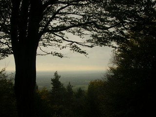
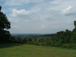
A very pretty forest walk, quite close to London, and the view from Leith Hill, the highest point in the Southeast.


Leith Tower, its woodlands & heathlands
| Length | 16.66 km (10.35 miles), 4 hours 40 minutes. For the whole outing, including trains, sights and meals, allow at least 8 hours 30 minutes. |
|---|---|
| Toughness | 6 out of 10. |
| OS Maps | Explorers 145 & 146 or Landranger 187. Holmwood, map reference TQ 175 437, is in Surrey, 6km south of Dorking. |
| Features |
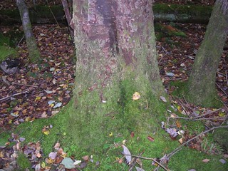
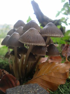
Much of this lovely walk is through National Trust land, the broadleaf woods and heathland of Coldharbour, Leith Hill and Abinger Common. Leith Hill with its tower is the highest point in south-east England, with views out across the Weald to the English Channel (with the tower, 1,000 feet). This walk is enjoyable at all times of year, but in particular:
The walk starts across fields before you cross the railway. An alternative start is also provided in the separate directions. After the two starting routes meet you soon reach the village of Coldharbour where you have a strenuous ascent to Leith Hill. Then its a steady walk up to Leith Hill Tower and the summit, where on a clear day you can enjoy some fine views. Next is a walk through woodland to the hamlet of Friday Street, the suggested lunch place. After lunch, the walk follows the Tilling Bourne stream to within sight of Wotton House; from there it goes through the National Trust's Deerleap Wood. The final stretch is through an open valley between the Surrey Hills and North Downs to the picturesque village of Abinger Hammer then on for tea to the mill at Gomshall with its functioning waterwheels oxygenating the water and attracting the trout. One short part of the walk on the ascent to Leith Hill near the start is a steep scramble, but this can be avoided by taking a longer, easier alternative to its side. Otherwise, the walk is easy going, mainly on sandy ways and bridleways. During wet winters and after periods of prolonged rain some of the bridleways in the woods can be churned up and muddy, the bridleways being well used by horse riders and their mounts all year round. The Tower (NT) is a folly, there is a small charge for climbing it, and there is a kiosk for a cup of tea or coffee and some nice cakes - ideal for Elevenses. It's also a nice picnic spot. Trains from Gomshall at weekends are only every 2 hours, so time you arrival carefully, or make use of the pub. Monday to Friday, trains at peak hours are usually every hour. |
| Walk Options |
Shortening the Walk You could catch a bus from Coldharbour; you could catch a 21 or 22 bus (operated by London & Country) from opposite the lunchtime pub in Friday Street, going to Guildford or Redhill; or you could catch a 32 bus opposite the Wotton Hatch pub in Wotton, again to Guildford or Redhill. These bus services are usually hourly. You could have tea slightly earlier, in Abinger Hammer, as detailed in the book's walk directions (then simply turn right, westwards, and stay on the A25 to Gomshall Station). Lengthening the walk If you want a long walk, try adding on Book 1 Walk 14, Gomshall to Guildford, making an overall walk of some 19 miles. Alternatively, you could add on the reverse of Book 2 Walk 13, Guildford to Gomshall, making an overall walk of some 17 miles. Both additions make an excellent, rewarding long walk. |
| History |
Leith Hill, the highest point in south-east England, is based on a 70 million-year-old sandstone bedrock, one formed by a cementing amalgam of sand and the silica from seashells. It was on the summit of Leith Hill in 851AD, that Ethelwulf (father of Alfred the Great) defeated the Danes who were heading for Winchester, having sacked Canterbury and London. Leith Hill Rhododendron Wood was created in the late 1800s by Caroline Wedgwood (of the famous pottery family) and eldest sister of Charles Darwin. She planted two large fields with rhododendrons and azaleas, some from Asia, as a formal park and garden close to the entrance to her property, Leith Hill Place . In 1944 the wood was bequeathed to the National Trust by Ralph Vaughan Williams, composer and grandson of Caroline Wedgwood. The wood suffered in the storm of 1987 when many of the trees in the wood were felled, but in recent years restoration work has brought the wood back to its formal glory. The best time of year to see the wood is in mid-May to June, and separate directions to it are given in these Directions. In 1765, Richard Hull built Leith Hill Tower with the intention, it is said, of raising the hill above 1,000 feet. He is buried underneath it. The Tower is open for people to climb up its 74 spiral stairs in summer from 09.00 hrs to 17.00 hrs and from 10.00 hrs to 15.00 hrs in winter. Admission (2022) is free to NT members and £3 for non-members. The Tower incorporates a kiosk which serves tea and coffee, soft drinks, cakes and sandwiches for those who like elevenses on their walk. Just down from the Tower is an Information Shelter which has a number of maps and pamphlets on places of interest and walks in the area. The Stephan Langton Inn in Friday Street (closed since July 2020) takes its name from the Archbishop of Canterbury who was born in 1150 and is said to have spent his childhood in this hamlet. Archbishop Langton was a subscribing witness to the Magna Carta, supporting the barons against King John and refusing to publish their excommunication by the pope. The Church of St John the Evangelist, near Wotton (open Sunday only) is of Saxon origin. It contains the tomb of John Evelyn, the essayist (author of, among other works, Fumifugium, or the Inconvenience of the Air and Smoke of London Dissipated) who was born at Wotton House in 1620. His diaries were discovered in an old clothes basket there in 1817. The monument to Samuel Wilberforce in Abinger Roughs marks the spot where this Victorian bishop fell from his horse and died in 1873. Known as ‘Soapy Sam’, he vigorously opposed Darwin’s new theory of evolution, most notably in a famous debate with Thomas Huxley in 1860. Hearing of his death, Huxley is said to have waspishly remarked that ‘Wilberforce’s brains had at last come into contact with reality, and the result had been fatal’. Abinger Hammer village is named after the Hammer Pond, which enabled the working of the iron industry furnaces here from Tudor times. The commemorative iron master's clock (seen on this walk) has Jack the Smith striking the hours. John Evelyn inveighed against the widespread felling of trees as fuel for iron works. In Sylva, first published in 1664, he suggested exploiting the developing world instead: ' 'Twere better to purchase all our iron out of America, than thus to exhaust our woods at home.' Gomshall Mill is mentioned in the Domesday Book, but the present mill dates from the seventeenth century. The Tilling Bourne stream (which springs out of the north slope of Leigh Hill) passes directly under the mill. |
| Travel |
Take the train nearest to 9.30am from Victoria Station to Holmwood. Journey time 1 hr 02 minutes. Note that there is no service on this line on Sundays and some Bank Holiday Mondays. Trains back from Gomshall on Saturdays run every two hours to Guildford (hourly at peak times from Monday to Friday), where you change for Waterloo, and in the other direction to Dorking and Redhill (you can change at either station for a train back to London). Journey time about 1 hour via Guildford, longer on the other routes. If you find you have a long wait for a train at Gomshall, you could take the hourly bus outside the Compasses Inn to Guildford or Dorking (Monday to Saturday only). Holmwood and Gomshall are on different lines with trains operated by different railway companies. If you want the option of travelling back via Guildford or Dorking Deepdene, you will need to buy a day return to Gomshall any route permitted . This will be valid as far as Dorking on the outward route and might be accepted to Holmwood, although you could be asked to pay a small supplement. Drivers: Holmwood has free parking. Change at Dorking (2 min walk between stations) to return to your car. |
| Lunch |
For slower walkers, and those leaving London on a later (10.30 am) train, your recommended lunch stop is the atmospheric 17th century pub and inn, the Plough Inn (tel. 01306-711793) in Coldharbour (some 2 miles into the walk), which serves food from midday to 2 pm weekdays, and to 2.30 pm on Sundays. The pub has a shop where snacks and hot drinks can be purchased for a picnic, and a micro brewery - an attraction for SWC beer drinkers. If this pub wasn't so close to the start of the walk it would make the perfect lunch stop. Elevenses can be taken at the kiosk within Leith Hill Tower, opening hours as per the Tower, details above. The recommended lunch pub for this walk used to be the Stephan Langton Inn in the remote and secluded hamlet of Friday Street, some 5 miles into the walk. But post coronavirus, the tenants of the pub decided to move on. The new owners of the pub succeeded in obtaining planning permission for change of use to residential in October 2023 - so the pub is no more: a great loss. With the demise of the Stephan Langton, your only option for a pub lunch on this walk is now the family friendly and walker friendly Wotton Hatch pub (tel.01306 887694) in Wotton, 40 minutes beyond the Stephan Langton pub, and some 11.5 km into the walk. This pub (more of a restaurant than a pub) serves food all day in comfortable internal and outdoor seating areas (both quite extensive) and has a good value set menu in addition to an a la carte menu . |
| Tea |
The early tea stop is in Abinger Hammer at the The Abinger Hammer Tea Rooms. What was the large and popular Tillings Cafe in Gomshall is now called The Lavender Goose (tel. 01443-202214). Closes at 5 pm. This is the recommended tea place nearest to Gomshall station. The cafe space is reduced in area from its Tillings days as it now accommodates a gift shop. To quote from its website, tea is served in a "light, shabby-chic style dining room". Do try it out for youself. A little further along the road is the suggested pub, the Compasses Inn (tel. 01483-202506) at Gomshall Mill, which is friendly to walkers and serves drinks and meals all afternoon and has a pleasant beer garden with a stream outside. |
| Updates |
Minor changes May 2018 (change in name of cafe). Directions to the Leith Hill Rhododendron Wood and directions for the alternative start added May 2017. Stephan Langton pub update March 2024. This latest book check version May 2023. |
| Book |
This walk was originally published in Time Out Country Walks near London volume 1. We now recommend using this online version as the book is dated. The book contained 53 walks, 1 for every week of the year and 1 to spare. Here is our suggested schedule |
|---|---|
| Profile | |
| Help Us! |
After the walk, please leave a comment, it really helps. Thanks! You can also upload photos to the SWC Group on Flickr (upload your photos) and videos to Youtube. This walk's tags are: |
| By Train |
Out (not a train station) Back (not a train station) |
| By Car |
Start RH5 4RB Map Directions Return to the start: Finish GU5 9NX Map Directions Travel to the start: |
| Amazon | |
| Help |
National Rail: 03457 48 49 50 • Traveline (bus times): 0871 200 22 33 (12p/min) • TFL (London) : 0343 222 1234 |
| Version |
Mar-24 Marcus |
| Copyright | © Saturday Walkers Club. All Rights Reserved. No commercial use. No copying. No derivatives. Free with attribution for one time non-commercial use only. www.walkingclub.org.uk/site/license.shtml |


Walk Directions
- For the Alternative Start, see the separate directions below (a little shorter, avoids crossing the railway line)
- [1] Leave Holmwood Railway Station, platform 2, not by the stairs but by the swing gate halfway along the platform. In 5 metres turn left on a quiet lane, your direction 65° initially, before the lane swings to the right. In 105 metres you come to the main road where you turn right, with a pond on your right-hand side.
- In 75 metres, at the other end of the pond, turn right by the phone box, on Merebank (road). In 40 metres ignore the fork right to the village hall. In 35 metres ignore Leith Road to the right, bearing left with the road, your direction 145°. In 40 metres ignore Leith Grove to the right. Then in a further 140 metres turn right on Woodside Road.
- Ignore all ways off. In 160 metres, at the Highland Road T-junction [2], carry straight on , following a signposted footpath, with a timber fence on your left, your direction 210°. In 50 metres you ignore a path off to the right.
- In a further 25 metres go down four steps and over a wooden bridge with railings, across a stream, over a stile, and follow the yellow arrow to the left, your direction then 145°.
- In 60 metres, by a two arm footpath sign, fork right with the path across fields, your direction 240°.
- In 575 metres, having ignored all ways off and crossed three stiles and a farm drive, you go up steps to cross the railway line.
- On the other side, you cross a stile to continue ahead, your direction 285°. In 65 metres go over two stiles with steps in between and continue upwards, with a field hedge on your left-hand side.
- In a further 125 metres you pass a manor house on your left-hand side (Trouts Grange).
- In 80 metres go over a stile beyond the tennis court (a metal fieldgate to its right-hand side) and in 15 metres turn right on a tarmac driveway , your direction 300°.
- Stay on this tarmac driveway all the way as it turns left, right and left again. In 330 metres inore a footpath to the right [ where the Alternative Start Route joins from the right ] , and the drive swings to the left.
- In 240 metres pass between metal gates painted white and out on to a tarmac road (Henhurst Cross Lane) [3] which you cross, your direction 240°, to enter The Bearhurst Estate on a public footpath, with its lodge on your right-hand side.
- In 35 metres, immediately after crossing a bridge with its stone parapet on your right, [!] take the footpath to the right between fences (the signpost may be half hidden in a hawthorn bush), your direction 310°.
- In 100 metres go over a stile,(missing May 2023) and keep ahead for 5 metres then turn left uphill, a field fence and woodland on your left-hand side, your direction due west.
- In 240 metres bear slightly left through a field boundary (a rusty metal fieldgate propped open on your left) and turn right on a grassy way along the right-hand edge of a field, with a hedge on your right, heading towards a stile in the top right-hand corner of the field, your direction 300°; (not the stile due west into the wood, 80 metres to the left).
- In 170 metres cross the stile (missing May 2023) and then another (a metal fieldgate to its left) to follow the yellow arrow uphill, your direction 255°. with woodland behind a fence on your left.
- In 215 metres, in the top left-hand corner of this field, go over a stile, with a metal fieldgate to its right. [!] Note: just before you reach this stile the ground tends to be churned up by horses and at certain times of the year the mud can be calf deep. Once over the stile, follow the direction of the yellow arrow, initially downhill then up, at 305°, aiming 50 metres to the right of the house ahead.
- In 250 metres go over a stile (a wooden fieldgate to its right) and in 15 metres you go through or around a wooden fieldgate and in 20 metres you cross a tarmac road, slightly to your right [!] to continue on a public footpath uphill with a footpath signpost 2 metres ahead and to your right, your direction 265°.
- In 12 metres you cross a path to continue on up into the National Trust Leith Hill Area woodland. In season you have carpets of bluebells on either side of the path.
- Follow the yellow arrows on posts on an undulating path as it winds through the woodland ahead and in 300 metres the path passes a bench seat on your right as it comes out onto a tarmac road where you go right.
- In 60 metres a sign on your right indicates that you are entering Coldharbour.
- There is an excellent, atmospheric country pub and inn, with shop and micro-brewery, the Plough Inn, 750 metres up the road, should you want an early lunch.
- In 140 metres you pass the entrance to the semi-detached Mosses Wood Cottage on your left-hand side. In 20 metres [4] [!] turn left and take the signposted public footpath (not the path through the wooden barrier, but the less clear path to the left of it), due west and very steeply up into the National Trust’s Coldharbour Common. This is a 1 in 3 path and a scramble on hands and knees in places.
- An alternative is the less steep route up past the wooden barrier, to the immediate right of the steep route. If taking this alternative route (particularly advisable if the ground is slippery after wet weather) ignore ways off and in 280 metres you come to a major path crossing and you go left, following the Coldharbour Walk arrows. In 260 metres you then rejoin the main suggested route at the asterisk [*] below.
- The very steep (main) route: in 40 metres or so your path is now a gully, still going very steeply upwards. At the top of the gully, in 40 metres, you follow a less steep, clear path, straight onwards, keeping due west. In a further 40 metres, with a footpath post on your right, you come to a path crossroads where you go left , your direction 190°; there is a yellow arrow on the post here, pointing ahead, but you go left .
- In 20 metres [*] you follow the National Trust Heathland Trail walk arrow (a green arrow on a low post with a green coloured top ) and turn half righrt , your direction 250°.
- Follow the green NT arrows ahead and in 15 metres you enter an area of chestnut coppice.
- In 60 metres keep ahead by another green arrown on a post on your right. In another 85 metres follow the green arrow by forking right, your direction 245°, as your path merges with the ridge path coming in from the left. Proceed along the undulating ridge path with a view over the Weald and the far line of the South Downs on your left-hand side. In 75 metres you pass a green arrow on a post on your left where a rough track descends on your right. You then pass a bench on your right.
- In 80 metres you pass a green arrow on a post on your right and keep ahead. In a further 170 metres, [!] by a post with indicators left to Landslip car park and right to Leith Tower, you turn right passing over a tree trunk barrier, your direction due west, on a downhill path. In 10 metres your path merges with a major track coming in from the right and you continue on this track downhill, ignoring the track to your left which passes through low wooden bollards. Keep ahead on this sandy track as it swings to the right, downhill, towards Leith Tower.
- In 150 metres you come down to a major cross paths with a NT sign over to your right for Dukes Warren. Ignore the car-wide wooden bridleway barrier straight ahead and instead turn left quite steeply uphill, your direction 240°, on a broad, sandy track which becomes very uneven under foot with ruts and tree roots as you head up to Leith Hill Tower.
- On reaching the Tower enjoy the panoramic views from this high point and if the kiosk is open you can partake in elevenses.
- Leith Hill Rhododendrum Wood Option See the separate directions below to visit the wood. Recommended in May.
- Otherwise, the main route continues as follows: just 10 metres beyond the Tower, continuing westwards, you fork right on a bridleway, your direction 320°.
- In 8 metres you pass a bench, 10 metres away on your right-hand side. In a further 90 metres, ignore a fork to the left . In 25 metres you cross a path.
- In a further 60 metres [5] while going downhill [!] take the left fork by a post on your right, gently uphill, your direction 310° (the right, equally main way, would have made your direction 5°). 450 metres from this fork, your path having bent left, you come to a T-junction where you go right, your direction 5°.
- In 100 metres ignore a car-wide track to the right. Continue gently downhill and in 25 metres ignore paths to the left. In 150 metres your way is joined by another earth car-wide way from behind on your right.
- Continue ahead, gently downhill and in a further 350 metres, at a three-way fork (where the right fork has a car-wide wooden barrier marked footpath), take the middle fork, your direction 355°.
- In 200 metres, by a three arm footpath post, a path joins from behind and to your left.
- [!] In a further 100 metres, at a crossing of paths with a four arm footpath post on your right, take the clear but zigzag path to the left uphill, your direction 285°.
- In 60 metres you come out onto a tarmac road, with Leylands Farm opposite. The route from Leith Hill Rhododendon Wood rejoins the main route here . Go right on the road, your direction 25°. In 30 metres [6] go left on a signposted public footpath, your direction 280°.
- In 150 metres you come to wide open fields where you turn right, by a two arm footpath post, with the field edge on your right-hand side and a wire fence to your left, your direction 5°.
- In 65 metres go through a metal kissing gate and turn left with the path to keep a field hedge on your right-hand side, your direction 275°. Keep to this path downhill and in 90 metres go through another metal kissing gate ahead and continue down a closed-in path, passing a house on your right-hand side. In 75 metres [!] turn right through a gap in the hedge by a two arm footpath sign, into the wood, your direction 330°.
- In 45 metres (where the fork right heads to a driveway in 10 metres) fork left, following the metal two arm footpath sign over to the right, downhill, your direction 285°. In 100 metres you pass the remnants of sheds (some demolished - site now a chicken pen- rest in poor repair) on your left-hand side.
- In 100 metres you continue on a tarmac house driveway, downhill. In 50 metres you come to a road T-junction – the end of a loop of road – and you go left, downhill, with Spring Cottage on your left-hand side, your direction 305°.
- In 70 metres ignore a bridleway signposted to the left, and a footpath signposted straight on, to swing right with a tarmac road, your direction due north.
- In 70 metres, with a car entrance to St John’s House on your left-hand side [7], you fork right on a bridleway marked by a one arm footpath post, down into woodland, your direction 15°.
- In 35 metres ignore a footbridge to your right. You keep the stream on your right-hand side all the way to Friday Street.
- In 400 metres ignore another footbridge on your right.
- In 140 metres your way becomes a lane between houses, leading in 60 metres to what used to be the Stephan Langton Inn in the hamlet of Friday Street on your right-hand side.
- Pass the former pub building on your right-hand side and carry on up the lane, due north. Ignore other ways off. In 110 metres you have a pond on your right-hand side. In 40 metres you come to a T-junction which you cross over, going slightly to the right to follow a public footpath sign, on a tarmac driveway downhill, your direction 35°.
- In 25 metres you pass Pond Cottage on your right-hand side. In a further 75 metres, you cross a stream on a low footbridge, where cars ford it.
- In a further 80 metres, by Yew Tree Cottage on your left-hand side, keep left with your road, joined by a driveway from the right, with the stream on your left-hand side.
- In 140 metres, with a four arm footpath post on your right at a cross paths, ignore the bridge on your left-hand side and keep on over a stile (with a wooden fieldgate to its left-hand side) into the parkland of Wotton Estate and to a series of ponds created by dams.
- In 320 metres you pass wooden fieldgates to your right and left, both marked ‘Private’.
- In 65 metres [8], by a three arm footpath sign, take the footpath fork to the right steeply up a gully, into the woods, your direction 25°, between fencing.
- In 320 metres, after the steep ascent has levelled out, cross a car-wide way marked ‘Private’ over to your left, to carry on now downwards, your direction 30°. In 160 metres drop down steeply to go over a stile to exit the wood on a path between wire fences, with open fields on both sides, and with Wotton House visible away on your left-hand side.
- In 65 metres go over a stream and enter a wood on a narrow path, uphill. In 30 metres go up three steps and keep ahead, uphill into the wood. In a further 85 metres go through a wooden kissing gate (with a road 5 metres below on your left-hand side) and carry on bearing half right across the grassy field towards the left of the house ahead, keeping a large tree in the middle of the field on your right-hand side, your direction 5°. (Ignore the stile in the left-hand fence, 75 metres away).
- In 240 metres go through a metal kissing gate (a metal fieldgate on its right-hand side) and in 12 metres carry straight on across a car park towards the A25. The Wotton Hatch pub (the recommended late lunch option) is to the left.
- In a further 60 metres, you cross the A25 and continue ahead on the tarmac lane to the Church of St John the Evangelist in Wotton.
- In 80 metres ignore a stile on your right-hand side. In 200 metres you come to the (usually locked) front door of the church and either take the footpath diversion to the left and around the churchyard, or fork left through the churchyard, in 25 metres passing a tombstone table supported by griffins. In 15 metres exit the churchyard by a stile on your left-hand side. Go right on the other side, on a clear path downhill between fences, your direction 320°.
- In 180 metres you enter Deerleap Wood (marked on the OS map) and you continue along the right hand edge of the wood, with a fence on your right.
- In 200 metres you exit the wood through a wooden kissing gate to continue straight on across a field. In 140 metres you come out on to earth road crossings [9] with a three arm footpath post on the left where you [!] fork left (but not sharp left),your direction 210°. In 30 metres you pass a timber-framed barn (held up by wooden posts) on your right-hand side and in 20 metres the entrance to Park Farm Cottage, also on your right-hand side.
- Keep straight on, following a blue arrow, with the edge of Deerleap Wood on your left-hand side. Soon you have extensive forestry clearing works in the wood over to your left.
- In 700 metres veer right with the path. In 60 metres continue in your previous direction (due west), with the wood on your left.
- In 190 metres you come to a tarmac road [10] where you go left for 10 metres, your direction 220°, to then merge with the public bridleway (whose signpost is 10 metres ahead) by a metal barrier on your left. Turn right , your direction 250°.onto a broad sandy track. In 25 metres you pass the National Trust sign for Abinger The Roughs. In a further 80 metres ignore a fork to the left to follow the blue arrow onwards.
- In 70 metres you pass the Monument to Samuel Wilberforce. Keep to the main path. In 360 metres ignore a sharp turn left and in 18 metres ignore a fork left. Go over a cross paths and bear right uphill, following the main trail, your direction 250°.
- Keep on this, ignoring ways off. Soon you have more rhododendron woods on your right with, in season, signs for NT "Rhody Trails". In 550 metres, at the other end of an open section, with a multiplicity of ways on offer [11], ignore the fork left, with its blue arrow, and keep straight ahead , your direction 260°.
- In 10 metres ignore a way to the left, marked with a green arrow.
- In 125 metres cross a path to continue on, gently downhill, a field fence now on your right-hand side and a farm visible down on your right-hand side (marked Hackhurst Farm on the OS map).
- In 145 metres you cross a farm track to carry straight on, following the blue NT arrow, through a wooden swing gate (to the right-hand side of a wooden fieldgate), still due west, with a hedge on your left-hand side and a wire fence to your right.
- In 160 metres go through a wooden swing gate. In 15 metres you come to a tarmac lane where you go left, downhill , your direction then 185°.
- But for the most direct route to Gomshall railway station, do not turn left downhill here, but cross the road, and turn right for a few metres before going through a wooden swing gate. Head between fields for 180 metres, to then enter Piney Copse . Do read the notice explaining the copse's connection to the author EM Forster. Head gently downhill on a meandering path through the copse, and in 205 metres exit the copse onto a surfaced lane. Here turn left, downhill for 175 metres until you come to the A25 road. Turn right along the road for some 375 metres before you reach the signposted tarmac path on your right which leads to the railway station.
- Following the main directions, having turned left downhill, in 300 metres you come down to the A25 road, with the former Abinger Arms pub on your right-hand side (now a Cookery School).
- For the Abinger Hammer Tea Rooms, turn left along the A25; the Tea Rooms are down the road on the left hand side, just before the post office. After tea here, retrace your steps to the junction by the former pub.
- [!] To head to Gomshall railway station ignoring the loop into Gomshall, stay on the A25 for some 600 metres, until 100 metres before you reach the railway bridge where you take the signposted tarmac path to your right, between houses called Copperfield and Russell House, which leads up to the railway station.
- Continuing on the main walk: Turn right, your direction 300°. In 200 metres, just past the red-brick, timber-framed house, turn left on a signposted public bridleway (a car-wide earth road), your direction 220°.
- In 80 metres you pass The Willows on your right-hand side. In a further 105 metres, you go over the Tilling Bourne stream. In 45 metres fork left (not sharp left) off the concrete road, your direction 265° ( following the right of two blue bridleway arrows).
- In 190 metres you come out on to an earth driveway. In 30 metres you come to an earth road T-junction, where you go right, your direction 285°.
- In 225 metres you pass the entrance to Twiga Lodge on your left-hand side and in 10 metres you take the second left, a narrow bridleway heading due west. In 150 metres, the bridleway having merged with a farm track, you pass a farmhouse on your left-hand side. In 60 metres you pass a manor house on your right-hand side, then a barn on your left. In 60 metres you come to a car road T-junction where you go right on Tower Hill Road. In 20 metres you go under a railway bridge and on to the T-junction, by a timber-framed house No 4 , where you go right on Goose Green Road.
- In 260 metres you come to Gomshall Mill on your right-hand side. The Compasses Inn , your suggested tea place, is to your left.
- After tea, turn right on the A25 road. In 225 metres fork left uphill, your direction 60°. In 160 metres you come to Gomshall Railway Station. Cross over the new pedestrian bridge over the railway to platform 2 for trains to Guildford, or stay on this side for Redhill.
Alternative Start to Walk
- At the road bridge end of Platform 2, go up steps to the road and turn left , to cross over the railway.
- In 150 metres, as the road swings to the right, turn left onto a footpath, to the right of a track, passing a redundant metal kissing gate. Keep on this narrow path betweeen hedges, and in a further 150 metres you emerge onto a tarmac drive, passing another redundant metal kissing gate. Keep ahead on this drive, your direction due west.
- In 300 metres ignore a signposted path on your left. In a further 160 metres, by a four arm footpath post, take the left fork and in 65 metres you pass through a metal fieldgate onto a woodland path, initially with woods on your right and a fence with a field beyond on your left. In 300 metres you have woodland on both sides of the path. In season you have some good bluebell displays on either side.
- In 175 metres cross a small concrete slab bridge over a stream and keep ahead. The path is now a broad track. In 150 metres the woodland ends on your right. In a further 100 metres you emerge into the open.
- In 70 metres you come to a major path junction, with a two arm footpath post over to your right. You now rejoin the Main Walk Directions by keeping ahead on the tarmac drive towards point [3] .
Detour to Leith Hill Rhododendron Wood
- Passing Leith Hill Tower on your right, keep ahead , downhill, due west, on a broad track, soon passing an Information Shelter on your left-hand side. You are now on the Greensand Way (GW)
- You now follow orange colour topped posts for the woodland trail, steadily downhill, with woods on your right and periodic openings in the woodland strip on your left for viewing and picnic spots.
- In 475 metres fork left off the GW following a woodland trail arrow, to pass through barriers, your direction 250° and head downhill on a narrow path through woodland. In places the path is deeply rutted and can be muddy.
- In 380 metres the path swings to the left and heads steeply downhill, with a stone retaining wall on your left. In 110 metres the path emerges onto Leith Hill Lane, which you cross over, to go down steps onto Tanhurst Lane, where you turn right .
- In 100 metres you pass on your left the entrance to Leith Hill Place car park and Leith Hill Rhododendron Wood . Enter the car park and pick up pamphlets and maps for the Wood from the Information Shelter on your left.
- Explore the Wood, spending as much time as you wish, either by following one of the set trails or just do your own thing. Whatever you do, you need to return to the car park and wood entrance when you have completed your visit.
- Retrace your steps onto Leith Hill Lane. You can either climb back up the path you came down, or - easier, if you don't mind a bit of road walking - turn left on this Lane, along its left-hand verge (no pavement), taking care as at times this road is busy.
- Head steadily uphill, and in 350 metres, just before the road swings to the left, take the bridleway to your right , marked by a prominent finger post. [!] Almost immediately turn left onto a path into woodland, your initial direction 15°. In 120 metres at a cross paths by a two arm footpath sign, keep ahead onto a bridleway.
- You are now going to head in a northerly direction in woodland over Wotton Common for just over 1 km on bridleways which as of Spring 2021 have been badly churned up following forestry clearance work, making a nasty mess of everything to the sides of what used to be a path and is now a muddy, rutted track. The joy of walking along the woodland bridleway has been well and truly spoilt. In 350 metres you pass through what was previously a glade, a break in the woods, to keep ahead.
- In 80 metres cross over a major cross tracks and keep ahead. In 700 metres you exit the woods at a track T-junction where you turn left . In 35 metres you come out onto Leyland Road, where you turn right .
- In 150 metres you pass the gated entrance to Leyland Farm on your left and on your right is a one arm footpath sign, indicating the path from which the route in the Main Directions emerges, some 30 metres before point [6] in the Main Directions.