Otford Circular via Romney Street walk
A short walk packed with variety and fine views, bluebell woods in season, a pretty village and a short train journey
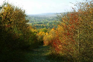
walk 43 View from hill above Otford
Nov-03 • Catherine Ames on Flickr
swcwalks book1 walk43 37325021475

Book 1 Walk 43 Otford (round walk)
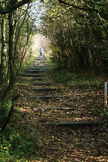
On the North Downs Way looking Southwards. D.Allen Vivitar 5199 5mp
Jan-06 • magyardave2002 on Flickr
way downs kent north book1 otford walk43 swcwalks 13198865533
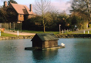
Pond life, Otford
I'll have to get a plumber in again! D.Allen ViviCam 5199 5mp
Mar-07 • magyardave2002 on Flickr
pond roundabout book1 otford walk43 swcwalks 429664897

Graze
Aug-09 • bernasmeister on Flickr
horse sun haze pasto glaze cavalo grazing swcwalksbook1walk43 5337045539

Romney Street, Shoreham and the Darent Valley
| Length |
12.0km (7.5 miles), 3 hours 30 minutes. For the whole outing, including trains, sights and meals, allow 7 hours 30 minutes. |
|---|---|
| Toughness |
6 out of 10. |
| OS Maps |
Explorer 147 or Landranger 188. Otford, map reference TQ 532 593, is in Kent, 4km north of Sevenoaks. |
| Features |
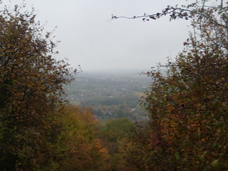
Being short in length, this walk makes a good, brisk, autumn or winter walk, with several ups and downs, although the walk is also delightful in bluebell season as the route passes through lots of bluebell woods during the morning. In 2023 there is a diversion at the very start of the walk, to avoid Chalk Pit woods - to control the spread of Ash Dieback. The route then continues steeply uphill, for a time following the North Downs Way, with views back over Otford and the valley, then going through Greenhill Wood, with a glimpse of Oak Hall, before heading north to Romney Street. You then have a steep descent to cross a former golf course for a short, steep ascent before dropping down to Shoreham village, for a late lunch at one of its pubs or tea rooms or vineyard. Shoreham village is worth exploring, with its twelfth-century church. After lunch the original TO Book route onwards is the Darent Valley Path through a golf course and over fields back to Otford, which offers two tearooms, a palace (in ruins), a church and many ancient buildings. It also contains the Otford Solar System, which claims to be the only scale model of its kind in the world - see History below. Mud warning : Although this is a lovely walk on a winter's day, at this time of year, particularly after periods of rain, many of the paths can be muddy or very muddy - and slippery - making progress in places tricky, so at such times do please wear appropriate footwear - and bring along a walking pole to help keep you upright. |
| Walk Options |
You can cut 0.8km off the end of the walk by following the short cut at [*] in the Walk Directions. This alternative route has the advantage of going close to the centre of the Otford Solar System (see above). It is also possible to get a train back to London from Shoreham. The detour to the pub in Cotman's Ash adds just over a mile to the walk length. Following the closure of the pub in Romney Street, and with lunch now deferred until Shoreham village, the afternoon of the original TO Book route is only 45 minutes, making for a rather unbalanced walk. To remedy this, you might prefer a more energetic return to Otford by reversing the opening leg of the Otford to Eynsford walk, which takes you up into Meenfield Wood before dropping down, either to Filston Farm for your return to Otford, passing the Solar System along the way, or along the river valley to rejoin the TO Book route mid-way through the golf course. This leg takes approximately 75 minutes. Directions for the longer route options are shown at the end of the main directions and after the detour to the Rising Sun pub, Cotman's Ash. |
| History |
Shoreham is the remote village which the 19th century landscape painter Samuel Palmer chose as a refuge from London's pollution. He was the leader of a group who followed William Blake and called themselves The Ancients . Palmer's father, also called Samuel, rented the Water House by the river. What was the Ye Olde George pub has been renamed after Samuel Palmer. The Church of St Peter and St Paul in Shoreham has many interesting features, including an outstanding wooden rood screen spanning the width of the building and a stained glass window by the Pre-Raphaelite artist Burne-Jones. Shoreham Memorial Cross is a striking feature on the hillside above Shoreham Village and below Meenfield Wood. It was cut into the chalky hillside in 1920 as a memorial to the local men killed during World War One. It is 100 feet in length, and can be seen for many a mile. Otford goes back to the sixth century when the Anglo-Saxons called their settlement Ottanford ('Otta's ford'). Offa and Canute fought battles here. The village pond, where the duckhouse is Britain's smallest listed building, was the main source of water for local people until the early twentieth century. The Bull pub in Otford has magnificent fireplaces, brought there from the ruined Otford Palace. Opposite the Bull is the Arts and Crafts-style Church Hall, designed by Edwin Lutyens who waived his fee, as it was commissioned by his brother William who was then vicar of Otford. Otford Palace once occupied four acres, but it fell into decay after Archbishop Cranmer was forced to surrender it to Henry VIII in 1537. A few fragments remain and are on open view. Construction of St Bartholomew's Church, Otford, began in 1060, with the tower being added in around 1185. The church contains large marble memorials to Charles and David Polhill, great-grandsons of Oliver Cromwell. The Otford Solar System is a full scale representation of the spatial position of the planets at a moment in time (midnight on 01-01-2000) and with the inclusion of four of the nearest stars located in museums around the world, it can lay claim to being the largest scale model of its type in the world. The model was constructed by the village as a Millennium Project, built to a scale of 1: 4,595,700,000. At this scale, the Sun is a little larger than a football - 30.3 cm across - and at the centre of the model, it can be found at the rear of the village recreation ground, a disc mounted on a concrete pillar. The earth is the size of a small ball bearing - 0.3 cm across - located 32 metres from the Sun. Jupiter, the largest of the planets is 162 metres away, the size of a small ping-pong ball - 3.1 cm across. To be found at various locations in the village, all mounted on similar pillars, are Saturn, Uranus, Neptune and Pluto. Mars - due to its location being between two football pitches - is represented by a ground level disc. The Otford Solar System provides visitors of all ages with an extraordinary insight into the size of the solar system and the larger universe in relation to our small planet. |
| Travel |
If deferring lunch until Shoreham, take the train nearest to 10 am from Victoria Station to Otford. Journey time 35 minutes. Fast trains back to Victoria are half-hourly (hourly on Sundays); there are also half-hourly slow trains where you may be able to change at Bromley South for a faster service. If driving, Otford Station car park costs £3.50 (cheaper at weekends). Alternatively, there is a free public car park in the village, opposite the Bull pub. |
| Lunch |
The lunch pub in Romney Street is long gone. Directions for beer drinkers are given at the end of the main directions to visit the Rising Sun in Cotman's Ash (tel 01958 522 683), a quirky, time warp of a pub, a former hunting lodge, with a fading pub sign. The pub's claim to fame used to be "Charlie", an African Grey parrot who used to entertain customers, but sadly he died in February 2016 (add your own Monty Python parrot sketch references here). The current landlady does not serve food but she permits walkers to eat their sandwiches on the premises provided that they purchase a drink. The detour to this pub adds just over 1 mile to the walk. With the closure of the Romney Street pub and the dubious merit in detouring to Cotman's Ash, your suggested lunch stop is now 3/4 of the way around the walk, in Shoreham. This village used to boast four fine pubs all serving more than acceptable food. Alas, post Covid-19, only two of these initially survived, although another has recently reopend under a new name. The attempt to save the fourth pub - the Two Brewers in the High Street - failed and the building is up for sale as a residential development. The three Shoreham pubs which are currently trading (autumn 2022) are the King's Arms, The Samuel Palmer and the Crown.
The King's Arms pub (tel 01959 523 100) in Church Street suffered a major fire in Spring 2022 which forced it to close, but it reopened after restoration work at the end of August 2022. They serve lunch seven days a week from 12 noon until 2.30 pm (later at weekends). This pub has comfortable informal indoor dining areas plus outdoor tables at the front of the pub and to its side, plus a large covererd - and in winter, heated - marquee. Booking ahead is recommended at weekends and on days (Wednesdays in 2022) when excellent value, two course pensioner lunches are on offer. The King's Arms claim to fame is that it has in its front wall the country's last remaining ostler box (like an enclosed little sentry box, where the ostler used to wait to attend to customers' horses). The second surving pub as of 2022 is the family run Crown pub (tel 01959 522 903) at 84 High Street, which serves home cooked, honest pub grub seven days a week apart from Thursdays (closed on this day), Monday to Wednesday from 12 noon until 4 pm, Friday and Saturday all day from 12 noon, and on Sunday from 12 noon until 4 pm. This comfortable pub tends to be less busy than the King's Arms and is a very good alternative to the latter. The third pub is The Samuel Palmer (tel 01959 525 442) - previously known as Ye Olde George Inne, in Church Street. This 15th century pub was substantially rebuilt - and renamed - in 2021 by its new owners. Open for lunch Tuesday to Saturday from 12 noon until 2.30 pm, and until 4.30 pm on Sunday, with sharing platters and bar snacks available on all days until late including Monday. What was the fourth pub - the Two Brewers pub - at 30 High Street is no more and the bnuilding is about to be lost to residential developmemt. For cafe food and lighter fare in Shoreham Village you have two choices, but only at weekends. The first is The Shoreham Aircraft Museum Tea Room - Battle of Britain Museum (tel 01959 524 416), open Saturday, Sunday and Bank Holiday Mondays, from 10am to 5pm. The Museum has a lovely tea garden which is a popular stop for SWC walkers not in need of a pub lunch. The second is the Honey Pot (tel 07546 696 623), open Friday, Saturday and Sunday, from 10am to 4pm. Wine buffs and lovers of English sparking wine might like to visit The Mount Vineyard tel 01959-524008, on Church Street, in the centre of Shoreham village - between Ye Olde George Inne and the King's Arms pubs. This vineyard has in recent years won awards for its wine tasting experience. Open from 12 noon to 6 pm Thursdays to Sundays and on Bank Holiday Mondays, you can sample the vineyard's wines whilst dining from their menu of sharing boards of cheese and charcuterie, stone baked pizzas and lite bites. Contact the vineyard if you wish to book a wine tasting tour in summer (from £ 35 a head) or in winter their hour's wine tasting (£ 30). Within the grounds of the vineyard you also find the Coffee Box , serving hot drinks and home-made cakes on Wednesdays and Thursdays from 10 am until 2 pm, and from Friday to Sunday from 10 am until 3 pm. |
| Tea |
The suggested tea place is the Hospices of Hope Otford Tea Room and Gift Shop (tel 01959 524 322), 11a High Street, Otford. This is a charity shop whose profits are used to support hospices in Romania and surrounding countries. Last orders are at 3.45pm Monday to Friday (4.15pm during British Summer Time), and at 4.45pm Saturday all year round. It is closed on Sunday. A very good alternative is the Pond View Cafe (formerly known as Willow Tea Rooms)(tel 01959 522 150) at 6 High Street, overlooking the village pond. The cafe is open from 9 am to 4-30 pm, serving cream teas, tea in pots and delicious cakes. Stronger fare is available at two pubs in Otford: the historic Bull (tel 01959 523 198) is run by Chef & Brewer; the other is the Woodman (tel 01959 522 195). What was the Crown pub now has an alternative use. |
| Updates |
No major route changes. [Older Editions] of TO Book - several changes. Use these online directions. This edition, main book check and walk update, January 2022. Pub updates July and October 2022. Diversion around Chalk Pit woods May 2023. |
| Book |
This walk was originally published in Time Out Country Walks near London volume 1. We now recommend using this online version as the book is dated. The book contained 53 walks, 1 for every week of the year and 1 to spare. Here is our suggested schedule |
|---|---|
| Profile | |
| Help Us! |
After the walk, please leave a comment, it really helps. Thanks! You can also upload photos to the SWC Group on Flickr (upload your photos) and videos to Youtube. This walk's tags are: |
| By Train |
Out (not a train station) Back (not a train station) |
| By Car |
Start TN14 5QY Map Directions |
| Amazon | |
| Help |
National Rail: 03457 48 49 50 • Traveline (bus times): 0871 200 22 33 (12p/min) • TFL (London) : 0343 222 1234 |
| Version |
May-23 Marcus |
| Copyright | © Saturday Walkers Club. All Rights Reserved. No commercial use. No copying. No derivatives. Free with attribution for one time non-commercial use only. www.walkingclub.org.uk/site/license.shtml |


Walk Directions
- [1] From the middle of platform 2 at Otford Railway Station, exit up steps with blue-painted metal handrails, then bear right on to a tarmac lane heading east away from the station, with woodland to your left. In 40 metres [!] turn left past a metal fieldgate on an unasphalted public footpath, through the woods, soon passing a Chalk Pit sign on your right-hand side. Veer left when you reach an open, grassy area and in 40 metres go up steps to pass through a wooden kissing gate on to a road.
- [!] In 2023 the Chalk Pit was fenced off to help prevent the spread of ash dieback from infected trees in the wood. If it has not reopened, retrace your steps and continue along the footpath above the platform to the A225. Turn right onto the pavement, then turn right again into Pilgrims Way East to rejoin the route at the exit from the wood.
- Turn right on the road for 10 metres, then go left uphill on a signposted footpath, the North Downs Way, initially a car-wide drive, to the left of a gravel drive, your direction 40°. In 85 metres the drive ends and narrows to an earth and gravel path, which soon climbs more steeply uphill. Continue ahead, initially between garden fences, crossing over access drives and go up a flights of steps, through light woodland, eventually coming to a bench on your left-hand side, with views back down to Otford and the Darent valley.
- Carry on up the path, going up more steps, still through light woodland. Near the top, where the path levels out, pass through a wooden kissing gate to soon follow the right-hand edge of the large open, grassy common, gently uphill. In 300 metres you pass a chest-high Ordnance Survey Marker 100 metres away on your left-hand side, and in another 100 metres you go through a wooden kissing gate to the left of a wooden fieldgate, to come out at a triangular road junction [2]. Here turn right downhill on a tarmac road signposted Otford and Kemsing, leaving the North Downs Way.
- In 100 metres [!] you go left up four earthen steps with a public footpath sign (a metal fieldgate to your left), your direction 75°, past Row Dow mini-reservoir on your left, and parallel to the vale below. Keep to the main path as it winds and undulates through woods. In 650 metres go through a wooden barrier and across a track to carry straight on through another wooden barrier, past a Kent Wildlife Trust panel for Kemsing Down.
- In 40 metres the path curves round to the right, goes downhill and then turns back left, with another path merging from the right. 100 metres from this path junction, continue past a large dead tree trunk on your right and by a bench seat on your left ignore a path to the right going steeply downhill. In a further 125 metres, turn right downhill at a path crossing, go down earthen steps rejoining the North Downs Way. In 25 metres go through a wooden kissing gate just below a wooden bench.
- Turn left along the hillside, your direction 70°, keeping to the main path. You have fine views over to your right. In 125 metres go through a metal kissing gate, leaving Kemsing Down.
- In another 200 metres, bear left uphill at a fork, following the North Downs Way sign, in 90 metres going through a wooden kissing gate to re-enter the wood. In a further 15 metres, you come to a main path crossing. The detour to the Rising Sun pub in Cotman's Ash starts here . The directions are at the end of these main directions. The main route continues as follows: at the path crossing turn left, leaving the North Downs Way to head north, uphill, in a cutting with a panel fence to your left. Keep straight on over a tarmac drive with the courtyard and part of Oak Hall on your left. In 40 metres go over another tarmac drive and, after another 40 metres, go over a stile into the corner of a large field [3].
- Turn left to go along the left-hand field edge to the next corner, 200 metres away, your direction due west. (On the OS map the right of way is shown as going into the field, then turning left at a path crossing to go diagonally across the field to the corner. But the path along the edge of the field is widely used and there seems no reason not to use it.)
- Leave the field through a metal swing gate, to the right of a fieldgate. In 80 metres this path ends and you go through a metal kissing gate on your left to come out onto a tarmac lane which is the driveway leading to Oak Hall. The Rising Sun detour re-joins here . [3A]. Turn right on this lane, to resume your westerly direction.
- Having gone past the drive's brick entrance columns, swing right with the lane as it joins a minor road (Shorehill lane) where you turn right, in 60 metres passing Thatched Cottage on your right-hand side, as you head due north. Ignore the North Downs Way signposted off to the left and continue along the road, past Shorehill Farm, Shorehill Cottage and then derelict farm buildings on the right, with a large modern house (Shorehill Bungalow) and barn at the bottom of a field on the left.
- You come to a road T-junction and turn left downhill, past Primrose Cottage on your right-hand side. 70 metres from the junction, at a dip in the road, [4] turn right on to a signposted public footpath, heading north. 350 metres down through the wood, on a rutted path with an uneven, stony footbed, cross a stile to exit the wood into a grassy field and continue in the same direction, soon going steadily uphill.
- In 150 metres exit the field by a stile (with two metal fieldgates on its left-hand side) and carry straight on, uphill, with the field fence and wood on your left-hand side. Pass through a field boundary then bear left down another grassy field, passing to the right of a house shielded by a wooden fence and tall fir trees, still heading northwards. Exit by a stile (with a wooden fieldgate to its left-hand side) out on to a tarmac road.
- [5] Turn left downhill on the road. In 20 metres at a public footpath sign turn right to go uphill on an enclosed narrow footpath, heading northwards. In 30 metres pass through a wooden barrier and keep straight on along the edge of a field.
- In 100 metres go over a stile into another field. Continue northwards with a wood on your right-hand side (or, if the field is churned up and very muddy, you could look for a path just inside the wood). In 250 metres exit the field by a stile (a metal fieldgate to its right-hand side) and then fork right off the main track, through a gap to the right of a metal swing gate, following a blue bridleway arrow, still heading northwards, and ignoring the track and metal fieldgate to your left.
- In 60 metres [6] you ignore the metal kissing gate and path on your right (the route to the former - closed - lunch pub in Romney Street) and instead keep straight on along the enclosed bridleway.
- In 150 metres the bridleway comes to a path T-junction with a wall ahead. Here turn left onto the path.
- In 60 metres go over a stile and ignore a yellow arrow pointing to the right. Just behind the boundary hedge to your right is a large field used as a private landing strip, where you can occasionally see light aircraft taking off or landing. You are now away from the last building and carry straight on downhill, your direction initially 300°, with Canary Wharf visible in the distance. Keep to the right of a small island of trees in a crater in the middle of the field.
- Exit the field by a stile, go across a car-wide track, and continue past a broken stile and head steeply downhill along the right-hand edge of a grassy field towards a disused part of a golf course.
- At the bottom of the steep slope go past another stile and continue across the disused golf links through a tunnel of overarching trees. Go through a metal kissing gate then head steeply uphill over a grassy bank to go through a metal kissing gate and enter a wood.
- Head uphill on a winding path through the wood and in 100 metres exit it through a gap in the fence ahead and turn half-left on a path across the corner of a large field, your direction 240°. In 80 metres pass through a field boundary to continue across another field on a path.
- In some 250 metres, at the end of the field, another farm track merges from the left and you turn half-right to join it, going downhill. Keep on this farm track as it goes uphill into Dunstall Farm [7]. Go more or less straight on through the farmyard, following a yellow arrow to veer to the right of the far barn, then left on a clear path across a field, your direction 260°.
- In some 240 metres, on the far side of the field, go down into the wood, in 50 metres crossing a path to carry on down four earth steps and then in a few more metres a very long flight of earthen steps. 350 metres from the end of the steps, your path merges with a bridleway coming in from the left, where your way swings right to carry on downwards, now through a woodland strip.
- In 200 metres, you come to a road junction with the A225. Cross this main road carefully and head west on Station Road, signposted Golf Course and Shoreham Village. In 60 metres you go under a railway bridge, and in a further 100 metres you ignore the main entrance left into Darent Valley golfcourse. But in a further 70 metres [8], your onward route is to turn left to head south on a footpath signposted Darent Valley Path.
- However, a detour to visit Shoreham village is recommended, particularly if you wish to have lunch in one of the village's pubs, or if you intend on visiting the Mount Vineyard. Stay on the car road for 70 metres beyond the Darent Valley Path. With Shoreham Place on your left turn right into an access way, to the left of a metal fieldgate and in a further 35 metres turn left through a kissing gate into the churchyard of The Church of St Peter and St Paul . Head down the path through the churchyard, to the left of the church. There are several benches in the churchyard, making it a good spot for picnickers. At the bottom of the path, you come out back onto the car road, at a bend, where you find on your left-hand side The Samuel Palmer pub (previously known as Ye Olde George Inne). Before the road swings to the right in a further 80 metres to cross a road bridge over the River Darent , you come to a bungalow on your right-hand side with a long access road leading to the Mount Vineyard . 70 metres beyond the bridge you come to the King's Arms pub on your left-hand side, your second lunch pub option in the village. After lunch in the village, retrace your steps to point [8] in the directions.
- Coming back to the main route, the Darent Valley Path: this leads through the golf course on an enclosed, tree lined path. After 370 metres, take care when crossing an open fairway. On its far side you enter an enclosed path and in 60 metres you pass to the right of a redundant metal kissing gate and onwards, now with a cricket pitch and a pavilion on your right-hand side, to follow a path between fences, still heading south, through light woodland. 100 metres along this enclosed path, you come to a major path junction.
- [*] For a shorter route back to Otford, you can continue ahead at this point. In 1.5km this path comes out directly opposite the Hospices of Hope tearoom, but 300 metres before this, opposite farm buildings, you can cross a stile on your right into the Recreation Ground. The centre of the Otford Solar System is in front of you, with an information panel 50 metres away by the hedge on your right.
- For the main route, however, [!] turn sharp right to head north-west on a tarmac lane, still following the signposted Darent Valley Path, gently downhill. In 250 metres, by a crossing of many paths, [!][8A] turn left to pass to the side of a "freestanding" metal fieldgate, with wooden circular bollards on either side, to follow the Darent Valley Path, by a ground level concrete sign 'Footpath to Otford', your direction 200°. Continue on the enclosed path through a narrow strip of woodland with glimpses of the golfcourse on either side.
- Carry straight on, following the Darent Valley Path signs, crossing over a cross paths. Once you are past the golfcourse, go through a metal kissing gate to exit the wood to come out into a large, open field, to continue along its left-hand edge, with the distant hum of M25 traffic across the valley to the right. In 350 metres you exit the field through a metal kissing gate, cross a minor access road, go through another metal kissing gate [9] and head down a path between fields, with a mesh fence on your right-hand side, heading towards Otford, now visible in the distance, your direction 150°.
- In 230 metres go through a metal kissing gate to continue ahead with the clear waters of the River Darent now on your right-hand side, later bearing left with the river's fork by a house on the far bank with unusual round brick chimneys. Go through a wooden kissing gate to pass alotments on your left, then you pass between gardens and houses, coming out onto a surfaced drive which leads out to the main road, where you turn left towards the village pond and station.
- You soon pass Pickmoss, a medieval half-timbered yeoman's house, on your right-hand side. Immediately next door is the old Baptist Chapel (at which Samuel Palmer's father was minister); and, a bit further on, the (partly sixteenth-century) Bull pub. Beyond this, also on your right and opposite a footpath signposted to Shoreham, you come to the Hospices of Hope tearoom, one of the suggested tea stops.
- Further along the High Street, overlooking the village pond, you come to the Pond View Cafe and the Crown and Woodman pubs. Head towards the Church of St Bartholomew on the far side of the pond (where a short detour to the right of the church would take you to the gatehouse and north-west tower, virtually all that remains of Otford Palace).
- To get to the station without going along the main road, take the tarmac path leading to a wooden gate in front of the church (to look inside, use the new entrance on its north side). Continue along the path on the south side of the church, with the churchyard to your right and later a brick wall to your left, and so through a wooden gate. You continue eastwards, in a further 250 metres reaching the car park of Otford Railway Station. The station's near platform is for London trains.
Detour to the Rising Sun
- Before setting out on this detour do 'phone ahead to check if the pub is open.
- At the main path crossing in the main directions, do not turn left, per the main walk directions, but instead keep ahead , going down, then up steps, over the path crossing, to stay on the North Downs Way, your direction 125°.Now bear left through a metal kissing gate and go up a flight of earthen steps. In 60 metres you come out into the open, with fine views to your right, and the brick walls to Oak Hall over to your left.
- In 150 metres at a footpath sign turn left and in 25 metres go through a metal kissing gate. Keep ahead over the field and in 90 metres go through another metal kissing gate and then in 20 metres a pair of metal swing gates, where you turn right, to follow NDW arrows on a path between low wire mesh fences, your direction 60°.
- In 100 metres go through a wooden kissing gate to the left of a metal fieldgate and keep ahead along the right-hand edge of an open field. In a further 105 metres go through a metal swing gate and keep ahead. In 150 metres in the corner of the next field go through a metal kissing gate to enter light woodland. In 100 metres ignore a path to the right and in a further 45 metres go through a wooden kissing gate, where you turn left along the left-hand edge of an open field, gently uphill.
- In 100 metres go through a wooden kissing gate and keep ahead along a broad, enclosed path. In 120 metres go past a redundant stile and keep ahead, now with a tall hedge to your right. In 60 metres go over a stile and in 15 metres come out onto a minor road, with the Rising Sun pub, Cotman's Ash, directly opposite.
- Coming out of the pub, turn right on the minor road, your direction west, and in 50 metres turn left onto a signposted, narrow footpath, your direction 235°. In 100 metres go through a metal kissing gate and keep ahead along the left-hand edge of an open field. In a further 90 metres go through a metal kissing gate and now keep ahead between fields, following a fenceline on your right-hand side.
- In 90 metres go through a metal kissing gate to enter woodland (Fabs Wood on the OS sheet). In 160 metres exit the wood through a metal swing gate to the left of a metal fieldgate and bear half-left to cross an open field, your direction 210°. In 200 metres pass through a field boundary and follow the direction of a footpath sign, slightly right, over the next open field, your bearing now 240°.
- In 220 meters at the far end of the field, cross a stile to the right of a metal fieldgate and keep ahead, with a surfaced drive over to your left. In 80 metres bear left over a stile onto the surfaced drive, where you turn right to re-join the main walk directions at point [3A].
Alternative route from Shoreham back to Otford (the reverse of the Otford to Eynsford walk opening leg)
- Coming out of the King’s Arms pub, turn left on Church Street. In 180 metres at the top of the street, at a T-junction with Shoreham High Street, turn right . In 25 metres you pass the Honey Pot tearoom on your right (open Fridays and at weekends only -2022).
- In a further 50 metres you pass Shoreham Aircraft Museum Tea Room on your left-hand side. Immediately turn left on a signed path – The Landway - next to the Museum, to pass the Tea Room’s garden on your left. Head up this path, with intermittent steps, passing playing fields on your right-hand side.
- In 180 metres ignore the entrance to Centenary Wood on your right-hand side and instead keep ahead through a metal kissing gate and continue up the path, now between hedges, ignoring ways off. In 130 metres go up two wooden steps to pass through a wooden kissing gate. You now have a good view over to your right of the Shoreham Cross WW1 Memorial made of chalk stones.
- Keep ahead, uphill, along the right-hand edge of a grassy field, following the line of a dilapidated wire fence separating grassy fields, your direction north. In 80 metres go up seven earthen steps with wooden risers to come out at a T-junction with the ridge path, at a cross paths, with steps ahead of you, and a sign for Meenfield Wood ahead and to the left of you. Turn left on this woodland path, along the contours of the hill, in places gently uphill. You have woodland to your right on the uphill slope and initially a narrow strip of bushes or trees on your left before the downhill slope. Latterly along the path you have woodland on either side.
- In 600 metres you come to the end of the path through the wood, which you exit through a metal kissing gate to the left of a metal fieldgate, to come out onto an open, grassy hillside. Bear left past a large, mature beech tree and then Turn left , quite steeply downhill, along the edge of the grassy field, with Meenfield Wood now on your left-hand side. In 150 metres at the bottom left-hand corner of the field go through a metal swing gate to head down a narrow path between hedges and tree line. In 8 metres you pass to the left of a rusty metal fieldgate and in a further 20 metres the path widens to a farm track, with hedges on either side.
- Head down the farm track and in 300 metres, at the bottom of the track, you pass to the left of a metal car blocking barrier to come out onto a car road – Filston Lane - with Water Lane a few metres to your left and opposite. Here you have a choice of onward route : The Darent Valley route – to rejoin the Main route - and the Farm route. In winter, when the Farm route can be muddy, the Darent Valley route is recommended.
- The Darent Valley route – to rejoin the Main route: cross straight over Filston Lane, slightly to your left, and head down Water Lane, with hedges on either side. In 200 metres at the bottom of this access road, with Kennel Cottage on your left-hand side, the road narrows to become a signed public bridleway, which soon swings to the left. Keep ahead on this pleasant woodland path, with the River Darent on your immediate right-hand side. You soon pass along the right-hand edge of Robins Wood. Some 210 metres from the start of the bridleway you come to a track junction by a ford crossing. Keep ahead over a narrow footbridge over the river and at its end bear left onto an earth and stone track which in 70 metres becomes a surfaced road. Head along the road, between properties, to cross back over the River Darent with The Old Mill House on your right-hand side. Now head up the road, quite steeply and in 200 metres you come on your right to a “freestanding” metal fieldgate with wooden circular bollards on either side. Here pass to the side of the fieldgate and take the footpath ahead (right turn from the road) with a ground level concrete sign – To Otford. This is point [8A] in the Main Directions, which you now rejoin.
- To continue on the Farm route : turn right on Filston Lane, almost opposite Water Lane. There is a bus stop on your left and on the road surface a 30 MPH sign. If you wish you may walk along the grassy verge to the left of the road. In 170 metres you pass on your left the entrance to Filston Oast. If walking along the grassy verge you now switch to the verge on the right-hand side of the road. In a further 100 metres you come to the entrance to Filston Farm on your left-hand side. The footpath originally went down the farm drive but you now [!] head down the gravel track to the immediate right of the farm’s drive, separated by a hedge. There is a finger post footpath sign part hidden in the hedge.
- In 75 metres with the farm ahead swing right over a farm apron to follow a permissive farm route avoiding the farm buildings. Pass through a pair of metal fieldgates (usually propped open) and in 25 metres bear left. In a further 25 metres turn right onto a footpath, with farm buildings and a feed hopper over to your left.
- Keep ahead on a clear footpath, your direction due south, between fields. In 75 metres pass a permissive path on your left to planet Pluto . You now have a choice of onward route: the route passing Pluto, and the main route, over agricultural fields. The routes are the same in length.
- The route via Pluto : Turn left along the permissive path between fields. In 145 metres pass through the hedgeline ahead of you to come out onto an earth farm track. On your immediate left you may find metal blocking barriers (missing November 2021) with a sign "Permissive path avoiding farm buildings". Turn right onto the earth track. In 250 metres you cross over a farm track crossing with metal fieldgates on either side and keep ahead, now on a path between hedges, with open fields beyond on both sides. In 400 metres you pass the pillar representing planet Pluto on your left-hand side. Keep ahead on the path, soon with woodland on your left. In 240 metres the path comes out at a junction with the path from the main route [2A]. Turn left and rejoin the directions in the main route.
- The Main Route over agricultural fields : Ignore the left turn (the Permissive path) and instead keep ahead and in 190 metres you pass through a field boundary and swing left, then right with the path between fields, soon with a wire fence on your left. In 200 metres you pass through a field boundary and keep ahead.
- In 210 metres you pass a field boundary on your left and the wire fence on your left ends. Now keep ahead between large open fields on a clear earth track. In 225 metres you pass a footpath on your right which goes down the side of an orchard. Keep ahead with the orchard on your right and in 100 metres you come to a track junction, where to continue ahead then right would take you to Sepham Farm and its oasthouses. At this junction pass to the right of a pair of metal fieldgates and turn left onto a grassy farm track, with a wire fence on your left and a hedgerow to your right.
- In 220 metres at a path and track junction [2A], where the route via Pluto joins from the left, with a metal fieldgate ahead and to the left of you, keep ahead (slightly right) on a footpath, with hedges or treeline on either side of you, your direction 140°. In summer the vegetation forms a canopy over the path. In 130 metres at a path junction, take the left fork , with a wire fence on your left. In a further 100 metres pass through a wooden barrier and in 10 metres cross a stream on a slab of concrete (a small hump bridge, with brick headwalls), to dog-leg left then right to keep ahead on what is now an enclosed path between fields.
- In 90 metres pass through a metal squeeze stile then cross a ditch and pass through a hedge to keep ahead between fields, with a post and mesh fence on your right and at times a treeline or bushes to your left. In 400 metres pass through a dilapidated wooden kissing gate in a field boundary and keep ahead over an open, grassy field. In a further 200 metres exit the field through a metal kissing gate to come out onto the main road, with a stone pillar representing planet Uranus on your left, and a bus shelter just beyond it.
- Turn left up the main road into the centre of Otford. In 250 metres, having crossed the River Darent on a road bridge, the Main route along the Darent Valley Path joins from the left. Continue with the Main Directions, for tea in Otford and your return to Otford Railway Station .