Whitchurch to Andover walk
Longparish, thatched cottages and the River Test
Bridge over the River Test
Rare sighting of the Lesser Redpoll(?) near Tufton Hants ViviCam 5.199mp
Jul-06 • magyardave2002 on Flickr
book1 swcwalks walk48 417777037


Longparish, thatched cottages & River Test
| Length | 19.0km (11.8 miles), 5 hours. For the whole outing, including trains, sights and meals, allow at least 9 hours. |
|---|---|
| Toughness | 3 out of 10. |
| OS Maps | Explorers 131 & 144 or Landranger 185. Whitchurch, map reference SU 464 489, is in Hampshire, 16km north of Winchester. |
| Features |
This is a lovely, longish walk that is neither steep nor particularly liable to mud. At lunchtime the walk comes to so many thatched cottages that a visitor to this country might suppose thatch to be the most popular roofing material for English country villages. The morning leg of this walk is glorious and takes you through some delightful, peaceful Hampshire open countryside. The route initially follows the line of a dismantled railway, then passes the Church of All Hallows in Whitchurch to go beside the crystal clear and gently flowing River Test – ‘England’s most famous trout stream’. On then to the village of Tufton, with its interesting church. A new path returns you to the route of the dismantled railway as you by-pass Paper Mill Farm. Then on to Longparish where you stop for lunch at one of its two pubs. The church at Longparish, with punishment stocks beside it, is your first stop after lunch. The walk then goes via a hamlet of more thatched cottages along the River Test before it follows a new detour over the A303 road to go up into Harewood Forest, past a vast piggery. A new route then takes you under the A303 before you rejoin the Book’s original route by Bere Hill Farm to continue on a straight footpath all the way into Andover, with its tearooms, pubs, church and museum. Just before Longparish is a three storey brick-built working flourmill (Longparish Upper Mill) on the River Test. If you give the owner a call (and some pre-warning: tel. 01264 720344) they may open it up for a guided tour, which is not normally available to the general public. One walker has described it as ‘fascinating and well worth the detour’. Just before Tufton you cross a field which in summer can be very overgrown with nettles – so the wearing of trousers, rather than shorts, is recommended on this walk. |
| Walk Options |
The first part of the walk is perhaps the more interesting, so you could catch one of the hourly buses to Andover, at lunchtime (after some 8.4 km of walking) from the Plough Inn at Longparish: or phone for a taxi from the Cricketers pub in Longparish. The afternoon leg of the walk is hard on the feet as the paths through Harewood Forest are mostly concreted. Some walkers find the afternoon leg through the pig farm and Harewood Forest disappointing, uninteresting and or boring - and a let-down after the glorious morning leg of the walk. Others enjoy the contrast between the morning and afternoon legs. Hence the afternoon is likened to Marmite. For the former group, the suggestion is armed with OS Explorer sheet 144, they plot a route via the pretty village of St Mary Bourne for a return, circular walk to Whitchurch, of about 14.5 miles. You can take a short cut from All Hallows Church Whitchurch to Tufton (although this misses out the delightful leg beside the River Test). But note: 2022 - this route has a CLOSED bridge before it rejoins the main route, so is undoable until the bridge repairs are finished - unlikely to be before Spring 2023. |
| History |
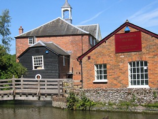
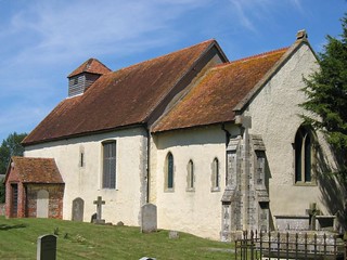
Whitchurch has a working silk mill, still powered by a waterwheel; visiting this involves a 1km detour from the main route. The Mill (tel. 01256 892065) at 28 Winchester Street, with a cafe and shop, is open 10.30 am to 5 pm daily - last admission 4 pm (closed Mondays, but open Bank Holidays). Admission (2022) £9.00. All Hallows Church, Whitchurch, has Norman arches and pillars with Victorian embellishments and a gruesome 1602 story picture about those who disobeyed the commandments (for instance ‘one stoned for gathering stocks on the Sabbath Day’). St Mary’s Church, Tufton, has a late Saxon chancel arch and an 800-year-old wall painting of St Christopher, depicted unrealistically so as not to infringe the commandment ‘Thou shalt not make any graven images’. Stocks for the punishment of offenders were erected in every village during the reign of Edward III. Those in Longparish are among the few still remaining. The Church of St Nicholas, Longparish, was perhaps used as a stable by Cromwellian troops. It has a stained glass window in remembrance of Major Hawker VC, an air force pilot shot down in 1916. Andover had its ancient heart of timber-framed buildings removed courtesy of a Greater London Council Town Development Scheme in the 1960s. The town has a museum (tel. 01264 366283) at 6 Church Close, just to the east of the church. It is open Tuesday to Saturday, 10 am to 5 pm, admission free. The church closes at 4 pm. It is made of Caen stone brought up the old canal from France; the stone was wrongly faced so the church is crumbling. George II used to stay at the Danebury Hotel in Andover on the way to his beloved Weymouth. Lord and Lady Nelson also stayed there. |
| Travel | Take the train nearest to 9.30am from Waterloo Station to Whitchurch (Hants). Journey time about 1 hour. Trains back from Andover run twice an hour (hourly in the evening and on Sundays). Journey time about 1 hour 15 minutes. Buy a day return to Andover. |
| Lunch |
You have a choice of two pubs for your lunchtime stop in the village of Longparish.The first you come to is the Cricketers Inn (tel. 01264 720335, some 7.5 km into the walk, which changed hands in March 2020. It has a varied menu of main courses, lighter meals (such as ciabattas) and starters to share, with sea food specials on most days. Lunch is served seven days a week between 12 noon and 2-30 pm in comfortable indoor surroundings and a large, partially covered beer garden. Booking ahead at weekends is recommended. Some 20 minutes further into the walk in Longparish you come to the Plough Inn (tel. 01264 720069), some 8.4 km into the walk, which closed in December 2015 following a chequered period of opening, failing and re-opening. The threat from developers seeking planning permission to convert the site into a residential development was thwarted by the Local Council which acquired the freehold interest in the property in 2020. The Council has subsequently granted a long lease to a Community Group which now runs the pub as a Community pub. After extensive refurbishmernt the pub opened in 2022, serving food on Monday and Tuesday between 12 noon and 2.15 pm, Wednesday and Thursday 12 noon until 2.30 pm, Friday and Saturday from 11 am until late, and on Sunday 12 noon until 5 pm. The menu is good and for weekends booking ahead is recommended. Almost opposite the Cricketers Inn you have a Londis Convenience Store where picnickers can purchase provisions for their lunch. The best spot for picnickers is the benches on the grassy lawns to the Church of St Nicholas (on the far side of Longparish). |
| Tea | There are several pubs in Andover, and most of the "usual supect" coffee shops, for your tea. Please note : from entering Andover on London Street it is a long haul to the railway station. Allow 30 mins for this last, and slightly tedious, leg of your walk. |
| Updates |
Minor changes and general updates, this edition October 2022. Several changes have been made to the walk route and directions since the original TO Book was published. These include diversions to avoid two dangerous crossings of the A303 road. Although the main route changes are recorded in the last (2011) edition of the TO Book, we recommend you use the on-line version of the Directions which have been updated since 2011. |
| Book |
This walk was originally published in Time Out Country Walks near London volume 1. We now recommend using this online version as the book is dated. The book contained 53 walks, 1 for every week of the year and 1 to spare. Here is our suggested schedule |
|---|---|
| Profile | |
| Help Us! |
After the walk, please leave a comment, it really helps. Thanks! You can also upload photos to the SWC Group on Flickr (upload your photos) and videos to Youtube. This walk's tags are: |
| By Train |
Out (not a train station) Back (not a train station) |
| By Car |
Start RG28 7ER Map Directions Return to the start: Finish SP10 3HW Map Directions Travel to the start: |
| Amazon | |
| Help |
National Rail: 03457 48 49 50 • Traveline (bus times): 0871 200 22 33 (12p/min) • TFL (London) : 0343 222 1234 |
| Version |
Oct-22 Marcus |
| Copyright | © Saturday Walkers Club. All Rights Reserved. No commercial use. No copying. No derivatives. Free with attribution for one time non-commercial use only. www.walkingclub.org.uk/site/license.shtml |


Walk Directions
- [1] On exiting Whitchurch Railway Station, go straight ahead, your direction 195°. You soon come to a car road T-junction with a ten-foot-high railway station sign on your right-hand side.
- Turn right downhill on this road (Evingar Road), which soon swings to the left. In 200 metres, as the road bends left, turn right downhill on Ardglen Road. In 100 metres you pass an ambulance station on your left-hand side. At the end of this building, [!] you should not follow the path to the right down into allotments [in the earlier versions of the TO Book] as this is not a public footpath.
- Instead, continue along Ardglen Road, soon passing light industrial premises on your left, then on your right. This road ends in a cul-de-sac, but 90 metres before the dead-end, turn right, your direction west and in 25 metres go through a metal barrier on to a fenced-in tarmac path. In 35 metres you come out onto Bloswood Drive where you turn left. You pass a row of bungalows on the right-hand side and in 160 metres you come to a car road T-junction [2].
- Cross over the road and follow the direction of a footpath sign, due south, through a wooden swing gate onto a surfaced path within a new large housing development. In 20 metres cross an estate road and continue ahead on the surfaced path. In 30 metres cross over a cul-de-sac end and keep ahead on the path, now gently uphill. In a further 105 metres at the top of the path, you leave the housing development through a metal swing gate to enter a narrow, enclosed earth and gravel footpath, with a close boarded fence on your right and treeline and bushes in front of a disused railway embankment on your left.
- In 25 metres you pass on your left-hand side a pedestrian tunnel under the embankment. In a further 35 metres the path goes up on to the embankment and straight on, with the old railway station (now a private house and garden) behind a fence on your left-hand side.
- In 45 metres the path swings left, then right, and now has a tarmac surface. In a further 15 metres you come out to a T-junction with a new cul-de-sac (Park View). Here turn left, and in 25 metres you come to a T-junction with a main road, Wells Lane.
- Turn right on Wells Lane (by a house called The Mount), gently downhill, your direction 190°. In 180 metres you come to a road junction (The B3400), with All Hallows Church, Whitchurch, on your left-hand side.
- The shortcut to Tufton starts here, see below.
- [2*] Turn left along the B3400 beside All Hallows Church and in 90 metres you come to the entrance to the church on your left-hand side. After visiting the church continue along the road in the same direction as before.
- If at this point you wish to detour to the Silk Mill, continue on this road for 450 metres and then turn right – the fourth turning – at a roundabout on to a road for 150 metres. Coming out of the Mill, continue on this road and in 1km rejoin the main route below at point [2A].
- Continuing on the main route, in 20 metres the road swings to the left just past St Cross House on the right-hand side. Here turn right on a signposted footpath, a car-wide track between walls, your direction 130°.
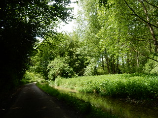
- In 75 metres go through a wooden kissing gate and in a further 10 metres you come down to the River Test , with a bench seat on your left. Turn right on the riverside path, with the crystal clear river (only about 8 km from its source in Overton) on your left-hand side. Keep on this riverside path, with a fence on your right-hand side and in 400 metres, as you approach Fulling Mill ahead of you, cross over a concrete bridge with wooden railings.
- 15 metres beyond the end of the bridge, you pass the entrance to Fulling Mill on your right-hand side. Here turn left over a concrete bridge with wooden hand rails and immediately turn right to continue straight on, your path parallel and 10 metres to the left of your previous path, your direction 140°.
- In 20 metres cross a wooden bridge with wooden handrails and keep ahead on a stony path, your direction 120°. In 20 metres beyond the bridge's handrails you cross a small concrete slab with a wooden handrail, with a "Millenium Greens" sign in undergrowth on your left.
- You now cross this ‘Millennium Greens’ project which regenerated this meadow from its previous wasteland state. Go over a grass path crossing and keep ahead, now on a grassy path. In 15 metres cross another path crossing, with a metal bench on your right. In 25 metres cross over a wooden bridge with wooden handrails. In a further 70 metres your path swings to the right and you exit the meadow through a wooden kissing gate, to come out on to a tarmac road, where you turn right, your direction 210°.
- [2A] (The route from the Silk Mill rejoins here.) In 165 metres, just after a sign for Whitchurch (thanking safe drivers) turn right on a crescent drive. In 65 metres you pass the rebuilt Ivy Cottage on your right-hand side.
- In a further 65 metres, as the crescent rejoins the main road [!] turn right down a path, with a footpath sign half hidden by a cypress tree to its right. Head diagonally across this field, half-left, your direction 200°, in 240 metres coming to the furthest corner of the field.
- Note: this field can be very overgrown with nettles in summer: to avoid them, stay on the road for a further 200 metres, then turn right under the A34, then right again, and head into Tufton.
- If you crossed the field, pass through a metal swing gate to the right of a metal fieldgate in the left-hand corner of the field and in 30 metres you come out on to a road where you turn right, in 30 metres going under a bridge (the A34), your direction 220°. 10 metres past the bridge, turn right down a signposted footpath, initially an earth track entrance way, your direction 320°.
- In 40 metres, by a metal fieldgate to your left-hand side, carry on along a narrow path between fences, your direction 350°. In 130 metres follow the path to the left, your direction now 255°. In 100 metres the field on your right ends and you keep ahead along a path with fences on both side. In 70 metres, at the end of the path and just before a private property, turn right then left to come out onto a driveway.
- Go left on this surfaced driveway, your direction 240°, in 20 metres coming to a churchyard on your right-hand side and in a further 30 metres a phone box on your left.
- The original road route from Tufton to Britwell Priors starts here, see below
- [3] Here you turn right on the road, your direction 320°, passing St Mary’s Church, Tufton on your right-hand side (well worth a look inside).
- Coming out of the church, turn right along the road which heads towards Manor Farm. With barn conversions on your right, the road swings left.
- In 150 metres you pass on your right-hand side a two-armed finger post with a path on your right leading to a footbridge. [3A] (The shortcut from Tufton rejoins here - but route not doable until the pedestrian footbridge has been rebuilt.
- Keep ahead, passing to the side of a metal fieldgate, and in 35 metres follow the direction of a yellow arrow on a post by [!] turning left up a bank and through a metal kissing gate to turn right along a field edge with the embankment to the dismantled railway on your right-hand side, steadily uphill at first, your initial direction 230°.
- This new footpath follows the railway embankment for the next 600 plus metres. In 325 metres pass through a field boundary and keep ahead, your direction 200°, staying alongside the fence and field edge on your right. In a further 300 metres the field comes to an end and you turn left along its bottom edge.
- In 90 metres turn right through a metal kissing gate and in 15 metres drop down to the road junction, where turning right heads to Hurstbourne Priors and Paper Mill Farm, and the road ahead towards Longparish. [!] Do not turn right down the road as the footpath through Paper Mill Farm is now closed. Instead [!] cross the road and turn right through a metal kissing gate, to turn half right between new saplings, your direction 160°.
- In 100 metres pass through a gap in the fence and turn right, following the direction of the footpath post, 220°, and go along the right-hand edge of a large, open field, gently uphill.
- In 90 metres, at the end of this field, turn left, your direction now 120°, down the edge of the field with a post and wire fence and hedge on your right-hand side, with a vast open field on your left.
- In 250 metres, at the bottom of the field, go through the field boundary and turn right, following the direction of the footpath post, 220°.
- In 75 metres go through a field boundary and the gap in the fence, to follow the path, at first right, then left, the latter bearing 210°. You have a hedgerow on your right-hand side as the path goes gently downhill to a dip, then starts to rise. Some 300 metres along this path, you pass an open barn on your right behind the hedge to come out to a junction with a gravel farm track.
- [!] Turn right - following the direction of the footpath post – and in 20 metres, with a metal fieldgate ahead of you – and a pair of metal fieldgates at right angles to it [!] turn left to follow the direction of a footpath post, due south, along the right-hand edge of a field, with a post and wire fence on your right, with treeline beyond, and a large open field on your left.
- In 240 metres go through a metal kissing gate and turn left down an earthen ramp with wooden handrail, then right down the ramp, to come out on to a farm track (Firgo Lane).
- Go under the bridge (to the disused railway) and keep ahead along the farm track, your direction due west, and in 150 metres you come out to the road, with Garden Cottage on your left-hand side. Turn left, to walk along the road.
- [3B] (The original road route rejoins here). In 100 metres you pass the rather beautiful Britwell Priors and garden on your left-hand side [In 1927 a colonel and his wife had these timber-framed farm cottages moved here from Oxfordshire, with – in those days – unhealthy water piped in directly from the River Test; at the previous site of the cottages, the well came up into the dining room.
- Some 60 metres past the front gate of Britwell Priors [4][!] fork right on a signposted footpath, your direction 235°, going through 3 wooden posts to go along a path through bushes and light woodland heading down to the River Test below on your right-hand side. In 400 metres you come out through a small gravel car parking area on to a tarmac road and turn right to follow this road alongside the river, your direction 280°.
- In 145 metres, fork left with the road, ignoring a path to the right leading to a footbridge. You soon have a shallow, clear stream on your right-hand side.
- In 325 metres, by a mini-weir and a farmhouse to the right-hand side, follow your road over a bridge with white railings and in 45 metres go over a second such bridge, with the farmhouse and old mill closer now on your right-hand side. In 20 metres go over a third (smaller) bridge with white railings.
- At the far end of the millhouse, the road swings right to cross a bridge over a weir. Do not cross this bridge but keep ahead, in 5 metres going through a gap to continue on the path, with the river on your right-hand side, your direction 315°.
- In 80 metres go over a wooden bridge with wooden railings and at its end go through a wooden kissing gate. Follow the direction of the yellow arrow on the gatepost and in 50 metres go through a wooden kissing gate to continue between post and wire fences, your direction due west. In 140 metres go over a wooden bridge with railings.
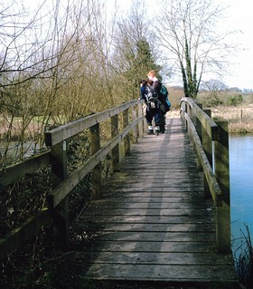
- In 90 metres go through a wooden kissing gate and on to a 40-metre-long wooden bridge between wooden railings (the bridge can be slippery), over the River Test and through another wooden kissing gate at the end of the bridge, with the moderately imposing Longparish House (marked on the OS map), now visible away over to your right.
- Keep ahead along the right-hand edge of a grassy field heading for a wooden kissing gate some 30 metres to the right of a stile, your direction 260°, in the direction of the thatched buildings beyond. In 70 metres go through this kissing gate and continue across the grass towards the thatched buildings, your direction still 260°.
- In 130 metres your path bends right, hugging the field edge on your right-hand side and in a further 110 metres you exit the field through a metal swing gate to come out on to the B3048 road, by the thatched Yew Cottage.
- Turn left on this B road, your direction 225°. In 30 metres you pass a Londis Convenience Store on your right-hand side and in a further 25 metres you come to the Cricketers Inn pub, Longparish, on your left, your recommended lunch stops.
- After lunch, turn left out of the pub and continue along the B road. 130 metres past the pub and by Little Newton thatched cottage on your left-hand side and Aston thatched cottage on your right, [!] you turn right up a driveway (that runs to the left of Aston Cottage), your direction 315°.
- In 40 metres, by a garage shed, go left on a surfaced footpath, your direction 240°, along the left-hand edge of a field. In 385 metres ignore a wooden kissing gate on your left-hand side to continue straight on. In a further 155 metres go through a wooden kissing gate (a metal fieldgate to its right-hand side) to continue straight on, across a field, in 100 metres passing a long wooden shed on your left-hand side, then a house. In 50 metres go through a wooden kissing gate to come out on to a tarmac road where you turn left, your direction 130°.
- In 10 metres [!] turn right on a signposted footpath (opposite Lower Farm House), passing the front gardens to a terrace of houses on your right-hand side, your direction 205°. In 60 metres go through a wooden panel gate and turn left around the edge of a soccer pitch, then right. In a further 60 metres, directly behind one of the goals, turn left through a gap in the hedge, your direction 145°. Follow the path ahead through trees and in 25 metres you come out into the car park of the Plough Inn , refurbished in 2021-22 and reopening as a Community pub Spring 2022. Walk through the pub's car park to come out onto a main road.
- Turn right on the main road, opposite a bus shelter, your direction 210°. In 150 metres, as the road swings to the right, fork left , your direction 235°, on the driveway shared with Longparish Church of England Primary School on your left and the Church of St Nicholas, Longparish. In 70 metres you go through the lychgate into the churchyard – but before going through the gate, note the punishment stocks 3 metres to its right.
- Take the left fork through the churchyard, passing the entrance to the church on your right. Leave the churchyard by the far (western) lychgate and pick up the clear, grassy footpath going right (past a thatched barn on your right-hand side), your direction 255°. In 85 metres you go through a wooden kissing gate and continue on, across a field on a grassy way, with the river over to your left.
- Follow the line of telegraph poles and in 225 metres go through a wooden kissing gate in the direction of the Test Way long-distance path (a blue TW arrow) and turn left, on a tarmac road, your direction 215°. (Your onward route follows these Test Way arrows into Harewood Forest: Note: older TW arrows are coloured blue, newer ones are coloured green).
- In 30 metres you pass a large building (Buckclose House) on your right-hand side and soon a haven of more thatched cottages. 440 metres further along this tarmac road, it swings to the right, with a farm track ahead leading to Forton Farm Cottages and Lyewoods.
- [!] You now follow the TW detour to avoid a dangerous crossing of the A303 road [5]. Follow the TW detour sign right, on the road, gently uphill, your direction 310°.
- In 200 metres, at the top of the hill, you come to a T-junction with another road. Cross over and go through a wooden kissing gate, to follow the TW sign across a large field, your direction due west, initially downhill. In 75 metres go under electricity cables and now keep ahead up the other side of this field. In 150 metres, at the far side of this field, by a footpath post, follow the TW sign left, your direction 145°, on a broken-surfaced farm track.
- In 55 metres go through a metal kissing gate to the left of a pair of metal fieldgates and in 20 metres you come to a T-junction with a road. Turn right, your direction due west and follow the road as it swings around to the left, in 120 metres going over the A303 road on a road bridge.
- On the far side of the bridge, ignore the turning right into Harewood Forest Industrial Estate, and continue down the road as it bends to the left. In 80 metres you come down to a T-junction with the B3048 road, where you turn right, signposted to Wherwell (there is also a TW sign on your right).
- Stay on this road, uphill, and in 160 metres, at the top of the hill, you pass Smallwood Lodge on your right-hand side. In 100 metres as the road descends and swings left, turn right off the road at a footpath and TW sign beside a sign to Pachington Copse and Middleton & Portway Estate, onto a surfaced road, your direction 295°.
- In 20 metres you pass through the old railway embankment (bridge deck removed, brick headwalls remain) into Harewood Forest (so marked on the OS map). In a further 20 metres, at an estate road junction, by a Pachington Copse sign, keep ahead, slightly right .
- In 25 metres turn left on a gravel track and in a further 15 metres go through a pair of metal fieldgates, to turn right up a concrete track, your direction 310°, following TW signs, gently uphill. In 125 metres the track swings to the left.
- In 50 metres you pass 2 large circular tanks on your left-hand side. In 15 metres you pass the end of a piggery shed. In 50 metres as the track turns sharply to the left [!] you follow the TW arrow on a post directly ahead , your direction 240°, into Harewood Forest.
- Follow green arrows on trees through the wood and in 275 metres pass to the right of a pair of metal fieldgates to come out on to a concrete track, where you turn right , your direction 260°. Now follow green TW arrows on posts as the concrete track starts to descend and then swings to the right.
- In 270 metres you pass on your right-hand side the first of 3 large piggery sheds – in turn nos. 4, 5 and 6. They look disused October 2022. After the last of these sheds (shed no.6), you continue straight on, your direction 290°, following a TW sign on a post on your left-hand side, as the path enters woodland.
- In 130 metres you come to a junction of paths, just after a metal cable barrier which you need to walk around. Continue straight on, taking the middle path, following a footpath sign, your direction 255°. In 35 metres you pass to the left of a metal gate across a car-wide track.
- Keep ahead, following TW arrows through the forest and in 480 metres you come to a track crossroads, with a footpath post on your left-hand side. Here you leave the Test Way and [!] turn right, a car-wide concrete track, gently uphill, your direction due north.
- In 150 metres you come to a fork in the concrete tracks and you take the main track ahead, slightly left , your direction 330° (the concrete pillar mentioned in the printed TO book has gone, Octobr 2022). Now progress steadily uphill on this concrete track and after 800 metres you come to a crossroads of tracks and paths [6].
- [!] In order to avoid the second dangerous crossing of the A303 road, your onward route is now as follows: at the crossroads, do not turn left as directed in previous editions of the Time Out Book, but instead cross over and by a footpath post with a yellow arrow on your left, take the grassy track opposite, passing to the right of a circular drum tank, your direction due north. This track can be muddy in winter.
- Continue ahead, between Furzy Croft Copse on your left and Popple Hill Copse on your right. Over to your right you soon see the Treerunners overhead zip wire course in the trees. In 220 metres the track merges with a gravel track and swings to the right, your direction now 20°. Keep ahead and in 90 metres you come to a crossroads. Here you turn left, on a gravel track with grass down its middle, your direction 260°.
- In 380 metres, just before the end of the wood, you come a T-junction of tracks. [!] Here turn left on the concrete drive and in 20 metres, as the drive swings to the left, [!] take the path to your right, your direction 245°. In 20 metres you exit the wood and come out on to a gravel track, with large open fields now in front and below you.
- Turn right on this gravel track and head gently uphill towards Cowdown Farm Buildings, your direction 350°. In 400 metres, just before the farm buildings, turn left with the track and come down on to Cowdown Lane.
- Turn right on the lane and in 100 metres [!] turn left off the lane to cross the concrete access to Solarcentury Cowdown Solar Farm (a vast new instalation, covering the hillside as far as the eye can see - a blot on the landscape and an eyesore) and pass through the metal swing gate to the left of a pair of metal fieldgates. Once through this swing gate turn right and following the direction of a footpath sign over to your right, of 350°, head down a car-wide gravel track, with the Solar Farm fence on your left, towards the A303 road. In 600 metres at the far end of the field, with the embankment of the A303 road behind the hedgerow ahead, turn left with the track along the bottom edge of this field
- In 90 metres pass to the right of a metal fieldgate and head down a surfaced track, in 85 metres turning right under a bridge carrying the A303 road above [7].
- On the far side of the bridge turn left, uphill along the track. In 95 metres at the top of the track, you are faced with a number of path options. From the alignment of the track directly behind you [!] Take the grassy track half right, your direction 310°, with a hedgerow soon on your right-hand side. In 60 metres pass under telegraph wires and keep ahead, gently uphill, on a grassy way, with a large open field to your left and a hedgerow to your right.
- In 360 metres, at the top of the incline, as the hedge on your right ends, and with a footpath post on your right, the track turns left and heads towards Bere Hill Farm, your direction now 225°. In 170 metres the track comes to a field boundary which you pass through, to continue ahead now on a grassy path.
- In 185 metres, at a cross paths, with a post with multiple yellow arrows on your left, turn right and follows the farm's fenceline on your left, to pass the farm's outbuildings behind, with an open field to your right. Head downhill on a grassy way, your direction 320°. You have a fine view of Andover ahead, through the trees.
- In 120 metres, at the bottom left-hand corner of the field, you go through a gap (where previously there had been an unusual metal pipe stile with metal footplates) and cross over a footpath (slightly to your left) to continue straight on down a flight of earthen steps, following a footpath sign, your direction 320°.
- Pass to the side of a redundant metal kissing gate and head down a further flight of earthen steps as you keep straight on all the way down to the main road (Eastern Avenue). In more detail: ignore all ways off and in 125 metres you have the start of allotments on your left-hand side and a playing field to your right on the far side of a hedge. At the end of the allotments go down a path between hedges and in 60 metres you come to a tarmac estate road and cross it, your onward path now visible for some distance ahead.
- In 40 metres go through concrete bollards and in 60 metres cross an estate road: the sign on your left tells you that the path is Dene Path. In 200 metres cross a road and keep ahead. In a further 80 metres Dene Path comes to an end and you continue straight on now along a tarmac road (Dene Road) towards the church soon visible in the distance. In 100 metres you reach the T-junction with Eastern Avenue.
- Cross Eastern Avenue by the lights to your right and go down London Street (slightly to the left on the other side of Eastern Avenue), past the Cameo Cinema, Café & Bar on your left-hand side and in 90 metres passing the Foresters Arms pub on your left-hand side.
- In 30 metres, turn right into the High Street and head up this street towards the Lower Guildhall and the church on the hill beyond.
- Pass to the right of the Lower Guildhall and keep ahead, soon passing on your left an entrane to the Chantry Shopping Centre.
- At the top of the hill you pass the Angel pub on your left-hand side and you continue ahead, now slightly downhill. In 60 metres you come to a Norman arch on your right-hand side, with steps up to St Mary's Church , Andover.
- To visit Andover museum, turn right at the church to get to Church Close, then left to the museum at 6 Church Close.
- To get to the railway station, however, [!] turn left into Chantry Street, just 15 metres before the church. Carry on down this road and in 100 metres cross the junction with West Street on your left and turn right on the access road into Andover Leisure Centre . At the end of the centre building turn left down its flank wall, pass the pond on your right to turn right in front of the yellow brick courthouse buildings. At their far end, with The Lights Centre and Theatre ahead of you, with Andover College behind, turn left down what used to be the flank wall of the courthouse - building being refurbished October 2022.
- Keep ahead to go over the river and under the underpass. In 60 metres at a T-junction with a car road, go right following the pedestrian sign to the station, your direction 315°.
- In 40 metres turn left up Bishops Way. Ignore all ways off as you head up this road, which soon swings to the right, and after 400 metres, at a T-junction, turn left uphill on Cross Lane, and in 20 metres you fork right for Andover Railway Station, now visible ahead. Go under the tunnel for trains to London (platform 1).
Option 1) Shortcut to Tufton
- [!] Note : this shortcut is not doable until the repairs to the footbridge before you rejoin the main route are completed - probably Spring 2023. At point [2*] (not marked in the book), instead of turning left by All Hallows Church, turn right on the B3400 and go under the bridge of the dismantled railway, then in 125 metres go under the bridge of the A34 road.
- In 20 metres go over the stile on your left-hand side and take the permissive path. Follow the grassy, car-wide track, gently uphill, your direction due south.
- In 100 metres cross a stile to the right of a wooden fieldgate, and follow the direction of the yellow arrow around the right-hand edge of the field which soon curves to the left, gently uphill, parallel to the road on your right.
- Pass 4 footpath posts with directional arrows on your right-hand side. After 280 metres, with the path having descended, bear right to go through a metal fieldgate (or when closed, over the stile to its right), to come out to a T-junction with a public footpath (which goes up to the road on your right.
- [!] Turn left at this T-junction, your direction 190°. In 15 metres bear slightly right to cross a stile, to continue ahead between fences on a footpath which is often overgrown.
- In 100 metres ignore a stile and a permissive path on your right-hand side.
- In 30 metres pass through a field boundary and in a further 60 metres go through a metal kissing gate, to follow the path, half left across a field, your direction due south.
- In 70 metres, at the bottom edge of the wooded embankment to the disused railway, cross a stile and turn right, to continue just within the woods at the bottom of the embankment.
- In 120 metres cross a 3 plank footbridge with a metal railing and in a further 15 metres go through a metal kissing gate.
- [!] Turn left and in 20 metres go under the bridge to the disused railway. Keep ahead, now with the river on your right-hand side.
- In 40 metres, just before you reach a metal fieldgate directly ahead of you, bear right, to go through a metal kissing gate. Cross a concrete 3-plank footbridge with a metal railing on its right (CLOSED 2022 - and being rebuilt) and continue ahead up a grassy path.
- In 30 metres you come out to a public footpath with a 2 way footpath sign on your left, where you turn right.
- Here you rejoin the main route at point [3A]. You start with “In 35 metres turn left up a bank and through a metal kissing gate to turn right.....”
Option 2) Original Road route from Tufton to Britwell Priors
- At point [3], do not turn right on the road to the church but instead turn left, your direction 140°.
- In 170 metres, at a road junction, turn right, your direction 240°. Keep ahead along this minor road, and in 670 metres the road comes down to a junction with a road on your right, signposted to Hurstbourne Priors. Do not turn right here (to join the previous Paper Mill farm route, now closed) but instead keep ahead on the road, your direction 210°.
- In 400 metres you pass Firgo Lane on your left-hand side, then Garden Cottage.
- Now rejoin the main directions, as above, at point [3B] You start with: “In 100 metres you pass the rather beautiful Britwell Priors…”