Merstham to Tattenham Corner walk
Viewpoints on the North Downs to start, a pub lunch in Mogador, and a London panorama from the Epsom Downs to finish.

CIMG6801
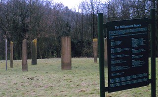
Millennium Stones, Gatton Park
May-13 • Sean O'Neill
banner, swcwalk4, swcwalks 5882381419956813010 P

DSCF8937
Coal Tax Post on Walton Heath
Jul-11 • Sean O'Neill
swcwalk4, swcwalks, walkicon 5633281288502800306 P

CIMG5127
View south-east from Colley Hill
Oct-14 • Sean O'Neill
swcwalk4, swcwalks, walkicon 6066052331944608482 P
CIMG5130
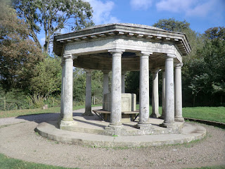
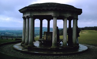
Inglis folly, Colley Hill
Oct-14 • Sean O'Neill
swcwalk4, swcwalks, walkicon 6066052271575449170 P
CIMG2210
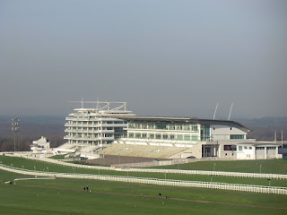
Epsom Downs Racecourse
Jan-16 • Sean O'Neill
swcwalk4, swcwalks, walkicon 6241108460084562178 P
Millenium Stones
Somewhere on the Merstham to Epsom walk. D.Allen Vivitar Vivicam 5199 24 Feb 2007
Jan-06 • magyardave2002 on Flickr
book3 walk4 swcwalks 411684033
New Year's Day walk from Merstham to Epsom
"Unisex toilets are fine - I'm not convinced by open plan ones though" Colley Hill, North Downs Way. 24 Feb 2007 D.Allen Vivitar 5mp
Jan-06 • magyardave2002 on Flickr
book3 walk4 swcwalks 414103878
| Length |
Main Walk: 17¼ km (10.7 miles). Four hours 10 minutes walking time. For the whole excursion including trains, sights and meals, allow at least 8 hours. Main Walk, finishing at Epsom (town): 18¼ km (11.3 miles). Four hours 20 minutes walking time. Short Walk, finishing at Tadworth: 11¾ km (7.3 miles). Two hours 50 minutes walking time. Short Circular Walk, from Tadworth: 8 km (5.0 miles). One hour 45 minutes walking time. |
|---|---|
| OS Maps |
Explorers 146 & (for the Epsom ending only) 161. Merstham, map reference TQ291533, is in Surrey, 3 km NE of Redhill. |
| Toughness |
4 out of 10 (3 for the Short Walk, 1 for the Short Circular Walk). |
| Features |
The Main Walk starts along the North Downs Way and soon reaches Gatton Park, which was landscaped by Lancelot “Capability” Brown. A choice of routes through this attractive parkland ends with a steady climb through woods to a popular viewpoint at Reigate Hill and the chance for a mid-morning snack. The fine views continue as you progress along the North Downs ridge, where Reigate Fort is a reminder that this was once seen as a defensive line protecting the capital. A little further on the open expanse of Colley Hill would make a good picnic spot, before you cross the M25 to the suggested lunchtime pub in the isolated hamlet of Mogador. In the afternoon the route goes across the large expanse of Banstead Heath (part of Banstead Commons) to Walton on the Hill. It continues through a small part of a First World War Centenary Wood being developed by the Woodland Trust (explored more fully in this walk's companion: see below). The walk ends with a dramatic finale across the famous Epsom Downs Racecourse on a public right of way, with a panoramic view of the London skyline if you take the suggested route behind the Grandstand instead of cutting across the racecourse to Tattenham Corner station. |
| Race Days |
The public footpaths across Epsom Downs Racecourse are kept open on some race days, but since 2016 they have been closed during major events (and for several hours before and after). Sadly, it is no longer possible to do the full walk on Derby Day. |
| Walk Options |
A shorter route to Reigate Hill gives late starters the chance to catch up with the main group. Several alternative endings are also described: a shorter ending to Tattenham Corner station (as in the original version of this walk), plus directions to two other stations in Epsom. Directions to and from the nearest station to Walton on the Hill (Tadworth) are also included, enabling both a Short Walk finishing there and a Short Circular Walk around Banstead Heath. |
| Additional Notes |
In 2022 one of this walk's options was transferred to a new Tattenham Corner Circular walk (#398), which features an extended section through the WW Ⅰ Centenary Wood. |
| Transport |
Merstham has half-hourly Thameslink trains via London Bridge plus Southern trains from Victoria (half-hourly Mon–Sat, hourly Sun), both taking around 30 minutes. For the return journey the closest station to the racecourse is Tattenham Corner, which has a half-hourly service to London Bridge. On Sundays there is only an hourly service requiring a change at Purley, with a slightly longer journey time. Tadworth station (for the Short Walks) is on the same line. The most frequent return service is from the station in Epsom town centre, which has trains every 10-15 minutes to Waterloo, Victoria and London Bridge. Hidden away at the end of a long residential street, Epsom Downs station has a half-hourly service to Victoria via West Croydon. All the stations on this walk are now on the Oyster network. Epsom Downs and the stations on the Tattenham Corner line are all in TfL Zone 6. For no discernible reason Epsom was placed in Zone 9, while Merstham is outside the numbered Travelcard zones. Oyster PAYG is now the most convenient option for this walk, although the fares are higher than you might expect from some stations (especially to Merstham). If you choose to buy a Zones 1-6 Travelcard or have a Freedom Pass you will need an extension ticket if you travel out to Merstham or return from Epsom. Walton on the Hill has a regular bus service (Metrobus 460) but there are no buses at Mogador, so you would need to call a taxi if you wanted to finish the walk after lunch there. Car drivers could manage the Main Walk by parking in Coulsdon and travelling to the start from Coulsdon South station, returning from Tattenham Corner or Tadworth to Coulsdon Town. |
| Suggested Train |
Take the train nearest to 10:15 from Victoria (or a Thameslink station) to Merstham. |
| Train Times |
|
| Timetables |
|
| Lunch |
The suggested lunch pub (after 8¼ km from Merstham; 4½ km from Tadworth) is The Sportsman (01737-224950) in Mogador. On the edge of Banstead Heath, it has a large beer garden and serves a good selection of freshly-cooked food, including burgers and pizzas.
The alternative places are 35 minutes further on in Walton on the Hill. The Blue Ball (01737-819003) reopened in May 2021 under new ownership, and the nearby Village Café (see below) does light lunches. |
| Tea |
If you want to break for tea in Walton on the Hill, the Village Café (01737-814171; open to 5pm Mon–Fri, 4pm weekends) serves home-made cakes, pastries and cream teas from a nice location overlooking Mere Pond. Stronger fare is available at the Blue Ball (see above) and The Bell, a quirky pub known locally as The Rat (01737-812132; open from noon weekends, 4pm Mon–Fri). Towards the end of the Main Walk there are a couple of up-market places on Epsom Downs. The Rubbing House (01732-745050) claims to be “the only pub in the world on a racecourse”; the alternative is the Derby Arms (01732-722330), behind the Grandstand. These are at least 20-30 minutes from the walk's possible endings, however. If you prefer to stop for refreshment nearer to Tattenham Corner station (or bypass the Grandstand with the shorter ending) you could grab a takeaway drink and snack at the Downs Lunch Box kiosk (open daily). There are several places in the parade of shops beyond the station, such as the Silver Spoon Diner (01737-668049; open to 5pm Mon–Sat, 4pm Sun) and the Wine Rack (a store with a few inside tables to try their wine or craft beers). The large pub at Tattenham Corner is currently closed, but the site has been acquired by Youngs and it should re-open in 2024. There are no refreshment places near Epsom Downs station but plenty of choice if you take the slightly longer ending to Epsom. A suggested place on the route into the town is The Amato (01372-721309), a “Grumpy Mole Restaurant” which serves afternoon tea from 3-5pm (Mon–Sat) as well as normal pub fare. There are many cafés, coffee shops and pubs in the town centre itself. If you finish the Short Walk in time there is a small café opposite the ramp leading down to the London-bound platform at Tadworth station, The Coffee House (01737-277422; open to 4pm Mon–Fri, 3pm Sat, closed Sun). The old station building now houses Station Fish for takeaway fish & chips, and a Mediterranean Bar & Restaurant, The Bridge (01737-213919). |
| Profile | |
|---|---|
| Help Us! |
After the walk, please leave a comment, it really helps. Thanks! You can also upload photos to the SWC Group on Flickr (upload your photos) and videos to Youtube. This walk's tags are: |
| By Train |
Out (not a train station) Back (not a train station) |
| By Car |
Start RH1 3ED Map Directions Return to the start: Finish KT18 5QD Map Directions Travel to the start: |
| Amazon | |
| Help |
National Rail: 03457 48 49 50 • Traveline (bus times): 0871 200 22 33 (12p/min) • TFL (London) : 0343 222 1234 |
| Version |
Dec-23 Sean |
| Copyright | © Saturday Walkers Club. All Rights Reserved. No commercial use. No copying. No derivatives. Free with attribution for one time non-commercial use only. www.walkingclub.org.uk/site/license.shtml |

Walk Directions
Click the heading below to show/hide the walk route for the selected option(s).


 Walk Map
©
Walk Options ( Main | Short )
Click on any option to show only the sections making up that route, or the heading above to show all sections.
- Main Walk (17¼ km)
Walk Directions
Click on any section heading to switch between detailed directions and an outline, or the heading above to switch all sections.
If you are doing the Short Circular Walk from Tadworth, start at §D.
- Merstham Station to North Lodge (1¾ km)
- Go up to the A23 and turn right. Keep ahead briefly into Quality Street and turn left onto the North Downs Way (NDW). Go past a cricket pitch and across a golf course. After crossing its access road continue on an enclosed path which eventually comes out onto Rocky Lane. Turn right and enter the grounds of the Royal Alexandra & Albert School at North Lodge.
-
Arriving from London, cross the footbridge and bear right across the station forecourt. Almost immediately turn left up Station Road and turn right at the top onto the A23. Cross the road at the zebra crossing and continue alongside it, passing a tiny Village Garden? on the left. Where the main road swings right keep ahead briefly into Quality Street?.
- You might like to make a short out-and-back detour along this cul-de-sac to admire its collection of attractive old houses, an unexpected survival in such urban surroundings.
- To continue the walk turn left off Quality Street after just 20m into Merstham Cricket Club's driveway, joining the North Downs Way?. At its car park bear right onto a path, passing the cricket pitch on your left. At the far end keep ahead up a gentle slope, heading W across Reigate Hill golf course.
- After a level stretch across grassland the path goes through a copse. Go across the golf course access road and continue along a track for 50m, then go through a wooden gate onto a potentially muddy enclosed path along the edge of a wood.
- In 300m the path leads into a driveway, at the end of which you bear left onto another drive to reach a minor road (Rocky Lane). Turn right onto this road, taking care as there is no pavement. Where the road turns sharply right after 100m, keep ahead past North Lodge into the grounds of the Royal Alexandra & Albert School, still on the NDW.
- North Lodge to Reigate Hill (3 • 2 km)
-
At a junction take the rightmost exit. Go between the school buildings and its playing fields to reach a three-way junction on the edge of Gatton Park. For the main route fork left, then loop through Nut Wood and cross a hollow to rejoin the NDW.
- Or fork right to stay on the NDW, following the shorter arm of a National Trust self-guided trail.
- Go along the tree-lined driveway for 200m to reach a junction, with a modern chapel on the right and St Andrew's church (which is usually locked) up ahead. Turn right and follow the drive through the grounds, between the school buildings and its playing fields. In 400m you reach a three-way junction on the edge of Gatton Park?, with the Millennium Stones? in a field ahead on your right.
-
Main route (3 km)
- At the three-way junction fork left, leaving the NDW. This bridleway initially goes downhill, passing Hop Garden Pond, then curves left and climbs back uphill. At the top of the rise you are heading S, with fine views.
- After the path bends to the right there is a fieldgate up ahead, but 40m before reaching it bear right uphill on a broad track and go through another fieldgate into Nut Wood.
-
Inside the wood immediately turn sharp right, going past another gate onto a broad path climbing near the right-hand edge of the wood. In 150m there is a bench by a gap in the trees, with a fine view across the parkland.
You might just be able to see the top of Gatton House behind some tall trees.
- The path now swings round to the left towards the centre of the wood, still climbing. Eventually the path levels out and 400m from the viewpoint you go past a wooden barrier into a more open part of the wood.
- Turn right at a path crossing by a waymarker post and follow the path through bracken, then back into a more densely wooded area. Stay on the main track as it goes across a hollow and back uphill, soon with more fine views across the park on the right.
- Halfway up the slope ignore an old stile leading onto the grassland and follow the main track up and round to the right. After climbing for a further 100m past this bend you come to a viewpoint by a path junction, where you turn sharp left to rejoin the NDW.
-
Shorter route (2 km)
- At the three-way junction fork right, staying on the NDW and passing an information panel about the sculptures, with a gate in the metal fence on the left giving access to them.
- In 200m the drive bends right towards a road. Just before Tower Lodge turn left onto a broad track climbing steadily through woodland.
- Ignore a path off to the left after 100m. In a further 300m fork left at a Y-junction, staying on the NDW (the right fork is a short cut).
- The NDW leads to a viewpoint over the parkland in 300m. Fork right at a Y-junction, joining the main route coming up from the other side of the hill.
- The path away from the viewpoint curves round to the right to head NW and passes a children's play area on the right (Gatton Fort). The path merges with the short cut mentioned in [?] and curves left to meet Wray Lane.
- Carefully cross this one-way road (traffic comes quickly up the hill from the left) and go across the National Trust's Reigate Hill car park, with its popular viewpoint on the left. On the far side the Junction 8 servery is a possible mid-morning refreshment stop.
- Reigate Hill to Mogador (3½ km)
- Cross the A217 on a footbridge and continue on a bridleway. This goes past Reigate Fort and eventually emerges on Colley Hill by the Inglis Folly. Take any route along its grassy slopes for the next 1 km. At the end rejoin the NDW for a short distance, then turn right onto a lane which crosses over the M25. Stay on this lane for 500m, then turn left into a cul-de-sac leading to The Sportsman.
- Cross the A217 on a white-painted footbridge to the left of the servery (by a “Horse Riders Dismount” sign). The straightforward route is to stay on the tree-lined bridleway, but you can also walk along the broad grassy strip to its right, which affords occasional distant views of the London skyline.
-
In 300m keep ahead at a path crossing to go past some cottages. Just before reaching some communications masts (where the two paths merge) the entrance to Reigate Fort? is on your left.
- If you detour into the site, return the same way; this is the only access point.
- Further along the bridleway passes Memorial Glade? and then an unidentified brick structure? in a smaller clearing on the left, before finally emerging onto open ground by what looks like a small circular temple, the Inglis Folly?.
- There are magnificent views to the south for the next 1 km. The main path curves away to the right, but it is much more pleasant to make your way along the grassy slopes of Colley Hill – or put in some extra hill walking! Eventually the contours of the ground lead you back past a National Trust sign for Colley Hill to the main path.
- Go through a wooden gate and head W along a bridleway. Ignore a door with a footpath sign in the fence on your right, behind which is a large country house. At the end of its garden fence ignore another path to the right by a white-painted Coal Tax post?.
- Shortly afterwards fork right onto either of two paths branching off the main path; the second is a short straight wide path, easier to follow. Both paths lead to a tarmac lane where you turn right to head N. Ignore lanes and paths off to both sides and follow the lane across the M25.
- On the other side of the motorway a signposted bridleway off to the left is a possible short cut.
- For the main route ignore the bridleway and continue along the lane, past a few houses in a wooded area. In 400m it merges with another lane from the left, then in a further 100m bends right at a junction marked by a Coal Tax post and a large pub sign. Turn left into this cul-de-sac to find The Sportsman pub on the right at the far end, on the edge of Banstead Heath?.
- Tadworth Station to Dorking Road (1½ km)
- From the station head south briefly on The Avenue and Station Approach Road, then turn half-right onto a footpath. Cross over another branch of The Avenue onto Banstead Heath and take a bridleway along its left-hand edge to the junction of the B2220 and the B290. Cross the B2220 and take the bridleway heading south-southeast. Shortly before it meets the B2032 (Dorking Road) turn left and go up to the main road.
- Arriving from London, go up a few steps from the middle of the platform to a road. Turn left and cross over at some point. Keep ahead at a road junction, then turn half-right at a footpath signpost onto an enclosed tarmac path going gently uphill. At the top turn right briefly onto a residential street.
- Cross the street and almost immediately turn left through a wide gap between houses into a wooded part of Banstead Heath?. Keep left at all path junctions, initially on a tarmac path but soon branching off onto a signposted bridleway. Follow this along the left-hand edge of the wood for 250m to come to a road junction, with New Road on the far side of the B2220.
- Cross the B2220 carefully and take the signposted bridleway to the right of New Road, into a less thickly wooded part of Banstead Heath. Just inside the wood keep left where the path splits and follow this fairly straight bridleway through the heath for 500m, going straight ahead at path crossings and heading SSE.
- About 50m before reaching a road (with a house visible on the other side) you come to a major path junction in a potentially muddy area, where you turn left onto a path going up a slope. At the top go past low wooden barriers, cross the B2032 (Dorking Road) carefully and go past more barriers onto an open part of the heath.
- Dorking Road to Mogador (3 km)
- Take a permissive ride heading east across an open plateau, then through a wood. Before reaching a roundabout on the A217 turn right onto a bridleway heading south-southwest near the eastern edge of Banstead Heath for 1¾ km, leading to The Sportsman.
- Turn half-left onto a broad grassy path signposted as a Permissive Ride, heading E. Follow this all the way across the plateau for 750m, passing some trees on the left after 200m and later another group on the right.
- On the far side of the plateau follow the horse ride into the trees, curving slightly to the right and gently descending. In 200m turn right at a T-junction with a bridleway and follow this downhill. At the bottom of the slope the bridleway bends left and merges with other rides heading towards the A217.
- Do not take this exit but veer right to continue on another bridleway going back into the trees, heading SW (if you were coming down the path from the road, you would be turning half-left). This soon curves gently to the left and climbs onto a more open part of the heath, later going alongside a tall hedge guarding a large house on the left.
- At the end of the hedge bear right through a wide gap in the trees into the corner of an open part of the heath, sloping down to the right. Bear left to head S on a broad grassy path at the top of this grassland. In 300m follow the main path as it turns slightly right, down towards the bottom corner.
- Go through a wide gap in the trees and take the mown path ahead through the heathland, initially heading SSW and gradually curving round to the left. In 400m it merges with another mown path from the right and carries on towards the far left-hand corner of the heath, now heading SSE. In this corner go past a vehicle barrier onto the end of a cul-de-sac, with The Sportsman pub the first building on the left.
- Mogador to Mere Pond • Tadworth Station (2½ • 3½ km)
-
Go onto Banstead Heath and take any convenient route heading north-west, gradually approaching Walton Heath golf course. Follow a path alongside the golf course to Dorking Road. Cross over and take a footpath forking right off a driveway through a lightly wooded part of the heath to Mere Pond.
- To finish at Tadworth station, take a bridleway heading north-northeast across a wooded part of Banstead Heath, coming out onto The Avenue. Cross over and continue on the footpath just off to the right, leading to Station Approach Road. Turn left and follow the road round to the right for the station entrance.
- Turn right out of the pub to go onto Banstead Heath, passing to the left of a vehicle barrier. In 75m, after passing the last of a few trees on the left, there are several mown paths off to the left across Chussex Plain. For the most direct route take the second of these paths, heading NW towards a distant Coal Tax post on the boundary of a golf course, 600m away.
- The path gradually curves right to thread its way through some gorse. After dipping past the left-hand end of a belt of trees, keep ahead up the other side to reach the golf course by the corner of a wood.
- In the corner of the open heathland take the sandy bridleway running between the wood and Walton Heath golf course?, heading N and later NW. For the most direct route stay close to the course and avoid paths going too deeply into the wood. In 1 km you come to low wooden barriers in front of the B2032 (Dorking Road).
- Cross this busy road carefully onto the driveway to Walton House, then immediately fork right onto a signposted footpath. Follow this broad path through a wooded part of Banstead Heath for 500m, going straight ahead at crosspaths to emerge at a clearing.
- Head for the far left-hand corner of the clearing, with the Blue Ball pub off to your left on Deans Lane. The path ends at the junction of Deans Lane with the B2220 (Walton Street), with the Spaghetti Tree restaurant? on the corner. The Village Café is 100m off to the left in the parade of shops opposite Mere Pond.
-
Finishing at Tadworth Station (+1 km)
- From the corner of Mere Pond take the lane (Withybed Corner) opposite Deans Lane. In front of the street sign bear right off the lane onto a signposted bridleway and follow this broad straight ride through the wood for 400m, heading NNE.
- On the far side keep ahead across a small clearing and go out between houses to a residential street. Turn right briefly onto the street, cross over and turn half-left at a partly-concealed footpath sign onto an enclosed tarmac path going gently downhill.
- At the bottom turn left onto a road and follow it round to the right at a junction, passing Station Fish and The Bridge restaurant in the old station building. Around the corner The Coffee House is in the parade of shops on the right-hand side of the road, opposite the ramp leading down to Platform 1 (for trains to London).
- Mere Pond to The Warren (3¼ km)
-
Leave Mere Pond on a lane along the edge of a wood. At the end of the wood, turn left onto a footpath, then cross a stile on the right. This footpath goes past paddocks, across two lanes and eventually meets a bridleway. Turn right and follow this downhill for about 500m, then cut through Langley Vale Centenary Wood on the left to the bottom of the valley.
- Alternatively you can stay on the bridleway, which swings left at the bottom of the valley.
- From the corner of Mere Pond take the lane (Withybed Corner) opposite Deans Lane. At the street sign fork right and follow the lane through woodland, later passing some houses off to the left. In 300m you pass The Bell pub and in another 100m leave the wood past a vehicle barrier.
- Turn left onto a footpath signposted to Ebbisham Lane. In 100m go over a stile on the right to head NW down another footpath. After 150m go over a stile and cross Motts Hill Lane to continue in the same direction past some paddocks. In 200m cross Ebbisham Lane and go over another stile, slightly to your right.
- Continue along the left-hand side of a narrow field, with a row of trees on your left. At the far end of the field go over a stile and turn right onto a chalky track, heading NW.
- Follow this bridleway gently downhill, soon with some large fields behind a wooden fence on your left. In 400m the path goes through a small wooded area and continues alongside a wildflower meadow for 100m, at the end of which there are new gates on both sides into the Woodland Trust's Langley Vale Wood?.
-
Main route
- Turn left off the bridleway, going through a wooden gate onto a grassy track heading W along the right-hand edge of a large wildflower meadow. At an information panel about Tadworth Camp? veer right onto a broad mown path going gently downhill, passing a memorial bench carved with soldiers' kit.
- In 500m you pass another memorial (for sailors) and the path turns left, dropping down through a plantation of young trees. At the bottom of the slope leave the memorial site through a gate and turn right onto a bridleway (Sheep Walk). In 100m this comes to a bridleway T-junction where you turn left, rejoining the original walk route.
-
Original route
- Continue downhill on the public bridleway. At the bottom of the valley it swings round to the left by Nohome Farm. In a further 300m the main route rejoins from the left at the bridleway junction with Sheep Walk.
- Almost immediately after the bridleway junction fork right onto another bridleway. This climbs gently through the trees and then curves to the right to emerge onto open downland.
- Go across a training gallop used for exercising racehorses and follow the bridleway up the slope, in 200m passing the start of another gallop on the right. Keep left to stay on the bridleway as it enters a more wooded area. In 50m there is a gap in the trees on the left by an information panel for The Warren.
- The Warren to the Grandstand (1½ km)
- Turn left onto a permissive path going across the meadow and a field, then around a small recreation ground. Turn left onto the public footpath heading north between a wood and the houses of Langley Vale. Bear left across Epsom Downs Racecourse to the Rubbing House pub, near the finishing post to the left of the Grandstand.
- For the main route turn left through the belt of trees, going around a vehicle barrier onto a permissive path through a small meadow. The grassy path curves round to the right and goes through the tree boundary into a field. Go diagonally across this to the far left-hand corner and through a gap into a small recreation ground. Make your way around the fenced-off central area to the opposite corner.
- Continue along a short path through some trees and turn left onto a broad chalky track. This public footpath passes the ends of three residential culs-de-sac as it goes across a dip and up the other side. At the top of the slope keep ahead as indicated by some new footpath signposts: across a training gallop and a short stretch of grassland, then along the left-hand side of some scrubland.
- The footpath comes out onto the back straight of Epsom Downs Racecourse, directly opposite the Grandstand. There is a gap in the perimeter fence just off to the left and another new footpath signpost on the other side of the racetrack confirms that you are entitled to cross it here, although you might have to duck under the inner railing to do so.
- After crossing the racetrack continue on a faint grassy path heading slightly to the left of the Grandstand, as indicated by the signpost. The path goes across a dip in the centre of the racecourse and leads to the Rubbing House pub by the finishing straight.
- The Grandstand to Tattenham Corner Station (1¾ km)
- Cross the racetrack and turn right, towards the Grandstand. Follow the path across the B290 (Ashley Road) and past the Derby Arms. After crossing the B289 continue alongside Grandstand Road. In 350m turn right to cross the road and follow a path through a small wood towards a roundabout on the B290. Follow this road round a right-hand bend and turn left, crossing Tattenham Crescent to reach the station.
- Cross the racetrack at the designated crossing point and turn right onto the tarmac path heading E, towards the back of the Grandstand. Follow the path round to the left and cross Ashley Road at the pedestrian lights in front of Derby Stables.
- Turn right and go along the broad tarmac path between the road and the stables towards another pub, the Derby Arms. Bear right across a patch of grass towards a roundabout and cross Downs Road carefully to its left. On the other side turn right onto a grassy path.
- Follow the path round to the left as it skirts a golf green and continues past a long car park on Grandstand Road; there is a toposcope identifying some of the places to be seen from this fine viewpoint across west London. At the end of the car park fork right to stay near the road, in 100m coming to a pair of small parking areas.
- Turn right to cross the road and follow a path from the back of the second parking area across a golf fairway. Continue through a wood, then bear left across another fairway. Shortly before reaching a roundabout, turn half-left at a path crossing.
- Cross Old London Road and keep ahead through a car park containing the Downs Lunch Box kiosk, serving snacks and drinks. If it has re-opened stronger fare will be available at the large pub 100m off to the right, on the other side of Tattenham Crescent.
- To complete the walk from the kiosk, cross Tattenham Crescent (heading towards the pub) and veer right across the grass towards the B290. Follow the road round a right-hand bend and across a section of the course where the five-furlong races start, taking care as there is no pavement.
-
On the other side of the racetrack veer left across a patch of grass to join the other arm of Tattenham Crescent. The station is set back on the other side of this road.
- The Silver Spoon Diner and a few more eateries can be found in the parade of shops up ahead.
- The Warren to Tattenham Corner Station direct (2¼ km)
- Keep ahead on the bridleway. Where it swings left to head north-east you can take a parallel route on the right, across open grassland. Rejoin the bridleway and follow it across Epsom Downs Racecourse and the B290, with the Tattenham Corner Beefeater off to the right on Tattenham Crescent. Continue briefly along the B290 and turn left into the other arm of Tattenham Crescent to reach the station.
- For the shorter ending keep ahead on the main track. In 250m ignore a signposted footpath off to the left (where the downs briefly come into view on the right) and follow the bridleway back into the trees. In 75m keep ahead at a bridleway signpost by another opening on the right, but after going back into the trees fork right off the public bridleway.
- In 250m this permissive bridleway emerges onto a broad strip of open grassland. Keep ahead on a clear grassy path towards a wide gap in the trees 400m away, where you rejoin the public bridleway.
-
Go across the back straight of Epsom Downs Racecourse at the designated crossing point. Follow the bridleway across the downland inside the course, with distant views of west London ahead.
- On the far side a short detour off to the right would take you to a commemorative plaque? on the inside rail.
- Go back across the racetrack on a driveway leading to a roundabout on the B290. Cross the main road to its right to come to …
- …
- …
- The Grandstand to Epsom Station (2¾ km)
-
 Cross the racetrack and turn left (away from the Grandstand), soon crossing Langley Vale Road on a bridge. Continue in the same direction all the way down Chalk Lane. At the end of this long road turn right into an alleyway (Madans Walk). Continue across Avenue Road and through Rosebery Park into Epsom town centre. Keep ahead across a series of major road junctions with the A24, then turn left into Station Approach.
- Cross the racetrack at the designated crossing point and turn left onto the tarmac lane heading W, away from the Grandstand and passing a Holiday Inn on the left. After this crosses over Langley Vale Road turn half-right in front of the gate to The Paddock and follow a short enclosed path down a slope.
- At the end continue downhill on a long straight ‘access only’ road (Chalk Lane); there is no pavement but very little traffic. In 1 km you pass the imposing entrance to The Durdans Stables on the left and shortly afterwards the (possibly closed) Chalk Lane Hotel.
- Another road joins from the left and you then pass The Amato, a good place for refreshments before the town centre. Where Chalk Lane comes to a T-junction with a main road at a bend, turn right into a broad alleyway (Madans Walk), signposted as a footpath.
-
Follow this footpath for 350m (crossing Avenue Road along the way), at which point you can veer right onto a parallel path inside Rosebery Park?. Go all the way through the park, passing a pond on your left. On the far side continue in the same direction on the B290 (Ashley Road) into the town centre.
- The B290 joins the busy A24 at traffic lights and in a further 200m you come to another set of lights at the junction with Epsom's High Street. On your left there are cafés and coffee shops in and around the Ashley Centre, plus several pubs in the market area around the prominent clock tower.
-
To complete the walk, go straight across the lights into Waterloo Road. In 100m turn left into Station Approach to find the station (and more coffee shops) on the right. Trains to London Bridge normally leave from Platform 1, Victoria trains from Platform 3 and Waterloo trains from Platform 4.
- The Grandstand to Epsom Downs Station (2¼ km)
- … In 700m turn half-left and cut across a corner of the golf course. Cross the B284 to the left of its junction with the B288 (Longdown Lane South). Head north alongside the B288 for 350m, then cross this road and go all the way down Bunbury Way to the station.
- …
- …
- …
- Carry on alongside Grandstand Road, passing another pair of small parking areas after 250m. Shortly afterwards fork left onto a grassy path cutting across a couple of golf fairways to meet the B284 near its junction with the B288 (Longdown Lane South). Cross the main road carefully to the left of the junction.
- Go gently downhill on a horse ride parallel to the B288, shielded by a line of trees. In 350m there is a gap in the trees opposite Bunbury Way. Cross the B288 carefully and go all the way down this twisting residential street to the station, 500m away.
- Merstham Village Garden contains replica cast-iron rails and an information panel about the Croydon, Merstham and Godstone Railway, an extension to the “first public railway in the world” (but only for horse-drawn freight wagons), the Surrey Iron Railway. This section opened in 1805 and operated for about 30 years before being superseded by the main Brighton line.
- Quality Street was the name of a 1902 play by JM Barrie, and when its leading actors moved to the 15thC Old Forge at the end of this street it was renamed. The eponymous sweets were launched in the same year as the 1936 film of the play, and the street scene on the tin was probably inspired by this picturesque cul-de-sac.
- The North Downs Way runs for 246 km along the length of the North Downs (with two sections at its eastern end), from Farnham in Surrey to Dover in Kent.
- Gatton Park was built up by Sir Jeremiah Colman, of mustard fame. The house (not visible from the North Downs Way) is now part of the Royal Alexandra & Albert School.
- The Millennium Stones were created by Richard Kindersley to mark the double millennium from AD 1 to AD 2000. The ten stones are inscribed with extracts from poems (one for each 200-year segment) inviting the traveller to “stop, rest and reflect” at this point on the Pilgrims' Way.
- Reigate Fort was part of a chain of forts built to defend London at the end of the 19thC, but the idea was soon abandoned. It is now owned by the National Trust.
- Memorial Glade contains an information panel and two memorial oak wing tips marking the crash site of an American ‘Flying Fortress’ in 1945.
- Recent research suggests that the brick structure might have been a listening post for monitoring radio communications during World War Ⅱ, but no documentary evidence of this has been found.
- The Inglis Folly was donated to the borough in 1909 by a Lt Col Inglis. It was originally a drinking fountain for horses.
- These cast-iron Coal Tax posts were erected in the 1860s to mark a taxation boundary. A levy on coal had been brought in to help pay for the rebuilding of London after the Great Fire of 1666, and with the growth of road and rail transport it was no longer practicable to collect it in the Port of London. There are several on the walk route.
- Banstead Heath is one of four open areas which make up the Banstead Commons. A wily developer tried to buy up the land for house building in the late 19thC and was only stopped after a 13-year legal battle; as a result the Banstead Commons Conservators were established to preserve the area.
- Walton Heath golf course has been the venue for several major golf tournaments, including the 1981 Ryder Cup.
- The Spaghetti Tree restaurant's name refers to a famous April Fool joke in 1957, when the BBC ran a hoax report on Panorama about a Swiss family harvesting a ‘spaghetti tree’ in their orchard.
- Langley Vale Wood is the largest of four World War Ⅰ memorial sites which the Woodland Trust began developing in 2014 to mark its centenary. The trust purchased these 640 acres of arable farmland and are planting 200,000 native trees; the site also includes extensive wildflower meadows.
- This area was the site of Tadworth Camp, where up to 8,000 new recruits were trained in trench warfare at the start of World War Ⅰ. Later in the war the area became a convalescence unit to cater for the extensive casualties.
- The commemorative plaque marks the spot where Emily Davison suffered a fatal injury when she threw herself under the King's horse in the 1913 Derby. It was erected in June 2013 to mark the centenary of this important event in the history of the suffragette movement.
- The 12 acres of land for Rosebery Park were donated to the council by Lord Rosebery, Prime Minister from 1894-95. He was a prominent figure in British horseracing and owned The Durdans, in Chalk Lane.
There is a choice of routes through Gatton Park to Reigate Hill, which are in fact the two arms of a National Trust self-guided trail waymarked with black metal posts. The main route loops through Nut Wood, while the shorter route in [?] stays on the NDW.
Continue the directions at §F.
Unless you are completing a Short Walk, go to §G.
The main route now cuts through part of this extensive memorial site, but if for any reason access is not possible you can follow the walk's original directions in [?].
If you are doing the shorter ending, go to §J.
If you are doing one of the alternative endings, go to §K to finish at Epsom station (in the town centre) or §L for Epsom Downs station.
The shortest route to the station is on the path inside the racecourse parallel to the finishing straight, but the route described below takes in a fine viewpoint.
Note that there are no refreshment places near Epsom Downs station.
Walk Notes
» Last updated: December 18, 2023
Return to Top | Walk Map | Walk Options | Walk Directions.