Rye, Dungeness and Lydd-on-Sea walk
Interesting coastal walk past an extra wide beach framed by sand dunes and an army range to an eerie shingle desert landscape with decommissioned nuclear power stations. Return by bus.

See the Sea through Sand Dunes in Camber
SWC 154 - Rye to Dungeness and Lydd-on-Sea or Lydd or Circular
Nov-17 • thomasgrabow on Flickr
swcwalks swcwalk154 banner 24963531718

Camber Sands
SWC 154 - Rye to Dungeness and Lydd-on-Sea or Lydd or Circular
Nov-17 • thomasgrabow on Flickr
swcwalks swcwalk154 walkicon 38805100072
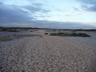
The Path (the red/brown-ish strip), Dungeness NNR
SWC 154 - Rye to Dungeness and Lydd-on-Sea or Lydd or Circular (Lydd Ending)
Nov-17 • thomasgrabow on Flickr
swcwalks swcwalk154 walkicon 23971082347

Sheep in Marsh
SWC 154 - Rye to Dungeness and Lydd-on-Sea or Lydd or Circular (Rye Ending)
Dec-17 • thomasgrabow on Flickr
swcwalks swcwalk154 walkicon 39371820551
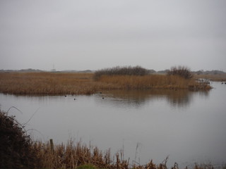
Birdlife in Reed-Ringed Water-Filled Pit, Dungeness RSPB Nature Reserve
SWC 154 - Rye to Dungeness and Lydd-on-Sea or Lydd or Circular (Long Lydd Ending)
Dec-17 • thomasgrabow on Flickr
swcwalks swcwalk154 walkicon 39342328572
![Big Sky and Cloud Scapes over Camber Sands SWC 154 - Rye to Dungeness and Lydd-on-Sea or Lydd or Circular [taken by Emma P]](https://live.staticflickr.com/4706/40178922602_168ea0ed9f_n.jpg)
Big Sky and Cloud Scapes over Camber Sands
SWC 154 - Rye to Dungeness and Lydd-on-Sea or Lydd or Circular [taken by Emma P]
Feb-18 • thomasgrabow on Flickr
swcwalks swcwalk154 walkicon 40178922602

Bonfire prepared (Fair and Bonfire Salts, Rye)
SWC 154 - Rye to Dungeness and Lydd-on-Sea or Lydd or Circular
Nov-17 • thomasgrabow on Flickr
swcwalks swcwalk154 27059961109
| Diversion for Seawall Works |
From mid 2023, multi-year strengthening works are taking place of the seawall along the River Rother between Rye and the Inshore Rescue Boat Station, en route to Camber Sands, leading to the official closure of the public footpath. Although early preparatory works did not impede walking along the closed footpath, as of late 2023 it is also blocked by fencing and impassable. A diversion starting at the bridge across the Rother, along a shared cycleway/footpath and across the golf course to the Inshore Station, is shown on the route map. |
|---|---|
| Length |
21.8 km (13.6 miles), with negligible ascent/descent. For a shorter or longer walk, or a circular option, see below Walk Options. |
| Toughness |
3 out of 10 (if hitting low to mid tides at Lydd Ranges and Dungeness, else tougher), with 4 ½ hours walking time (longer if not hitting low or mid tides at Lydd Ranges and Dungeness).
|
| Walk Notes |
This is a fascinating and most unusual walk, initially leading from the historic Cinque Ports Town of Rye along the Rother River to Camber Sands with its shallow and wide sandy beach lined by magnificent sand dunes and with a selection of lunch stops. You then follow the coastline either along the beach or atop the seawall through the Lydd Firing Ranges (open for only about 65 days a year), a scenic area of sand dunes, water-filled ex gravel pits and tidal basins with plenty of bird life, and eventually entering the desolate, vast expanse of shingle (one of the largest in Europe and the UK’s only desert) that is the Dungeness National Nature Reserve. You pass the Dungeness Nuclear Power Stations then turn inland past a couple of lighthouses and a few tea options in Dungeness and continue past Derek Jarman’s famed garden to The Pilot Inn in Lydd-on-Sea, from where buses take you back to Rye or on to Ham Street or Ashford stations.
A circular option from Camber back to Rye through grassy marsh land cuts out all shingly sections and makes this an interesting all-year walk, even when the military range is shut to the public. An alternative ending from Dungeness leads through the shingly Denge Beach area and a large RSPB Reserve to Lydd. |
| Walk Options |
A Circular Walk back to Rye from Camber (from the easterly edge of the village through the marshes) is 17.6 km/11.0 mi long (1/10).
Short Walks by car
|
| Maps |
OS Explorer: 125 (Romney Marsh, Rye & Winchelsea)
|
| Travel |
Rye Station, map reference TQ 919 205, is 86 km south east of Charing Cross, 4m above sea level and in East Sussex. Lydd-on-Sea (The Pilot Inn) bus stop, map reference TQ 090 186, is 17 km east of Rye and 6m above sea level. Lydd, map reference TR 043 209, is 5 km northwest of Lydd-on-Sea. Lydd and Lydd-on-Sea are in Kent. Rye Station is on the Marshlink Line from Hastings to Ashford with an hourly service, linking to High Speed I trains to Stratford and St. Pancras International (total journey time: from 69 mins). Lydd-on-Sea (The Pilot Inn) Bus Stop has the following services: Line 102 to Folkestone and Dover (7 days) and Line 11 via Ham Street to Ashford (Mon-Sat). Line 102 also has Mon-Sat evening services to Lydd. On school days, there is also an afternoon service to Lydd (Line FGS1). In Lydd, most buses connect well to Rye. Saturday Walkers’ Club: Take a train no later than 10.40 hours if planning to lunch in Camber. Take an earlier train for lunch in Dungeness and/or if walking a long version of the walk. |
| Lunch |
The Owl 11 Old Lydd Road, Camber, Rye TN31 7RH (01797 225 284). The Owl is located 6.1 km/3.8 mi into the walk.
|
| Tea |
In Dungeness:
In Lydd-on-Sea:
In Lydd:
In Rye:
|
| Danger Area |
The middle part of this walk goes through Lydd Firing Ranges which are only open for about 65 days a year. You MUST check the range opening times before doing the full walk. There are options to do shorter walks either side of the ranges. Firing Times : S.E. Training Estate (then "Lydd"), Googling "Lydd Firing Times" or "CPTA Firing Times", or phone 01303 225 518 (Range Control) to get opening times. [May-20] |
| Shingle |
The beach through the Lydd Ranges is sandy with some shingle topping but all shingle above the High Water Line, which is very hard to walk on. You can walk behind the beach, or on the sea wall in some places, but it's much better to do this part of the walk at low or mid tides when you can walk along the mostly firm sandy strip just below the High Water Line. Therefore, try to do the walk with low tide in the early afternoon. Check the tide times! |
| Camber Sands |
The tide goes out a long way at Camber Sands beach uncovering sandbars. Explore these on a falling tide only! Beware that the tide comes in quickly and can cut you off. There have been fatalities here. Check the tide times! |
| Coast Path |
The England Coast Path (ECP) opened in 2016 from Camber onwards past Dungeness to The Pilot Inn (and on towards Folkstone). However, the route detours inland around the Lydd Ranges. This section is not recommended, as it's a very long detour, and much of it is a slog along the Range's perimeter road.
|
| Lydd Ranges | Lydd Ranges are only open for about 65 days a year. They are open for a 2 week period at Christmas, a period in August, and the rest of the 35 days are scattered throughout the year. Walking inland along roads around the ranges would be very long and not much fun. |
| Links |
|
| Tides |
20-Apr :
low: 04:42
high: 10:14
low: 17:06
high: 22:22
21-Apr :
low: 05:30
high: 10:48
low: 17:49
high: 22:57
22-Apr :
low: 06:07
high: 11:16
low: 18:24
high: 23:28
23-Apr :
low: 06:39
high: 11:44
low: 18:53
high: 23:56
24-Apr :
low: 07:09
high: 12:11
low: 19:23
25-Apr :
high: 00:21
low: 07:41
high: 12:35
low: 19:54
26-Apr :
high: 00:46
low: 08:12
high: 12:59
low: 20:25
Times for Dungerness. Corrected for BST if appropriate. Contains ADMIRALTY® tidal data: © Crown Copyright and database right.
|
|---|---|
| Profile | |
| Help Us! |
After the walk, please leave a comment, it really helps. Thanks! You can also upload photos to the SWC Group on Flickr (upload your photos) and videos to Youtube. This walk's tags are: |
| By Train |
Out (not a train station) |
| By Car |
Start TN31 7AB Map Directions Finish The Pilot, Lydd-on-Sea, TN29 9NU Map Directions |
| Amazon | |
| Help |
National Rail: 03457 48 49 50 • Traveline (bus times): 0871 200 22 33 (12p/min) • TFL (London) : 0343 222 1234 |
| Version | |
| Copyright | © Saturday Walkers Club. All Rights Reserved. No commercial use. No copying. No derivatives. Free with attribution for one time non-commercial use only. www.walkingclub.org.uk/site/license.shtml |


Walk Directions
Full directions for this walk are in a PDF file (link above) which you can print, or download on to a Kindle, tablet, or smartphone.
This is just the introduction. This walk's detailed directions are in a PDF available from wwww.walkingclub.org.uk