South Downs Way 3 : Petersfield to Cocking walk
Follows the South Downs Way along the crest of the South Downs with good 360 degree views throughout.

On the downs after lunch
Petersfield to Cocking walk
Jul-16 • Saturdaywalker on Flickr
swcwalk155 swcwalks walkicon 28106687053

Descending to Cocking
Petersfield to Cocking walk
Jul-16 • Saturdaywalker on Flickr
swcwalks swcwalk155 walkicon 28644666851

Buriton
old burial ground/picnic site
Aug-13 • magyardave2002 on Flickr
book3 swcwalks walk155 9474385058

BEACON HILL, South Downs Way
Summitting Beacon Hill, it's that man again! (Our High Commander, DAC)
Aug-13 • magyardave2002 on Flickr
book3 southdownsway swcwalks walk155 9556962388

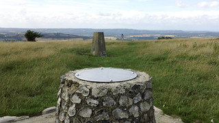
DESCENDING BEACON HILL
S Downs Way near Cocking
Aug-13 • magyardave2002 on Flickr
book3 southdownsway swcwalks walk155 9554134735
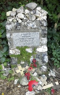
Fallen Battle of Britain flier
AIRMAN'S CRASHSITE TRIBUTE ON SOUTH DOWNS WAY Hauptmann......
Aug-13 • magyardave2002 on Flickr
book3 swcwalks walk155 9474283866
| Length |
12.7 miles/20.4 km |
|---|---|
| Toughness |
7 out of 10 (466m of ascent) |
| Maps |
You'll need OS Explorer Maps OL8 (was 120 - Chichester) and (for the first 2km) OL33 (was 133 - Haslemere), or a guidebook to the SDW with maps |
| Features |
This is a ridge walk along the South Downs Way (SDW). A good, easy to follow path, with some steep ascents in the westerly half of the walk, but only gentle ups and downs east of the Devil's Jumps, and fine 360 degree views for most of the way. It's a different kind of South Downs Way from the more familiar sections further east. Quite wooded and with big sections on tracks and lanes. The first half would actually make a good bluebell walk and it would not be a bad autumn colour outing either. The scenery in this mid section is wonderful - classic grassy downland, with lots of ups and downs and great views. After more woodland there is a long track section through flowery meadows and a beautiful descent to Cocking, perhaps the best scenery of the walk. It is best to bring a picnic, as the only pubs are very early, or at the bottom of the South Downs ridge which you need to re-ascend afterwards. From Petersfield Station, the walk goes through the town square, then heads south from to Buriton (4 km) along the Hangars Way following a small stream. There is an option for very early pub lunch in Buriton Then it's up on to the ridge for the main part of the walk (16 km) which follows the SDW along the crest of the South Downs ridge, past Tower Hill (has a folly), Beacon Hill (242 metres, ancient hill fort), Treyford Hill and Linch Ball (hill, trig point just north of the SDW path). At Harting Down, just before Beacon Hill, you can head 1,1 km north, down off the ridge to the pub in South Harting. A little further, you can head 800 metres south to Uppark, a NT Historic Country House with a tea room (you need to pay admission to enter). These are the only refreshment possibilities on this part of the walk. The SDW meets the A 286 road just south of Cocking which has a bus stop. Optionally, leave the SDW 1.5 km earlier on Cocking Down, and head north east along a path towards Cocking village (1 km north along the A 286 road) which has The Bluebell restaurant-pub to await your bus. There is a good bus connection south to Chichester, or north to Midhurst, where you can change for Haslemere (on the same line as Petersfield, so a much cheaper train ticket). For a group, a taxi would be comparable in prices. Options
|
| Lunch |
|
| Links |
|
| South Downs Way |
This walk is one of 9 stages of the South Downs Way - a 109 mile national long distance path - that traverses the South Downs National Park in South East England. |
|---|---|
| Cocking |
Bus Travel from CockingThere is a bus stop where the SDW meets the main road, or you can walk 1km north to Cocking village where there is the Bluebell restaurant-pub to wait for the bus.
The 'change buses in Midhurst' trick does not work on the Amberley-Cocking walk. On Mon-Sat only, you could take the #60 north to Midhurst, then change to the #1 to Pulborough (see below). However, it costs an exorbitant £8 ("Dayrider Gold") Theses bus details were correct in Dec-17, but are very likely to change - check before you travel using:
Taxi: "Paddy Cars. £20 to Haslemere for up to 7 people. t: 01730 263263 | 01730 262279. Folks can relax in the Bluebell Inn while waiting - journey time about 25 mins". You need to book in advance on sunny summer weekends. Places to Stay2-Day Walk : Petersfield to Cocking to Amberley via the SDW This makes a great 2 day walk. Buy a period return to Chichester (where the 2 rail routes converge, or 2 singles). Cocking is a hamlet with a pub-restaurant. Midhurst, to the north is a small town.
|
| Midhurst |
Travel from Midhurst Updated Nov-21Catch a bus to/from a station, preferably on the same rail line you arrived from. If not possible, buy a more expensive ticket to Chichester, which is valid on both rail lines. Bus times change frequently. Check before you travel. Especially the time of the last bus!
There are 4 bus routes to choose from. Portsmouth Direct Line from Waterloo to Haslemere or Petersfield
Arun Valley line from Victoria to Pulborough or Chichester
Both lines (a more expensive ticket to Chichester is needed, valid for all the above stations)
Taxi from Midhurst BJ's Private Hire (01730 716 327 or 07732 590 806). Uber is about £20 for Midhurst to Haslemere. |
| Profile | |
| Help Us! |
After the walk, please leave a comment, it really helps. Thanks! You can also upload photos to the SWC Group on Flickr (upload your photos) and videos to Youtube. This walk's tags are: |
| By Train |
Out (not a train station) |
| By Car |
Start GU32 3EE Map Directions Finish Hillbarn Lane, Cocking, West Sussex Map Directions |
| Map Walk | This walk requires an OS map and a compass or GPS for navigation. You can print out OS maps using the link above. |
| Amazon | |
| Help |
National Rail: 03457 48 49 50 • Traveline (bus times): 0871 200 22 33 (12p/min) • TFL (London) : 0343 222 1234 |
| Version |
Dec-17 Andrew |
| Copyright | © Saturday Walkers Club. All Rights Reserved. No commercial use. No copying. No derivatives. Free with attribution for one time non-commercial use only. www.walkingclub.org.uk/site/license.shtml |


