Sawbridgeworth to Bishops Stortford via Henry Moore Foundation walk
Sawbridgeworth, gently rolling countryside, fields, woods and waterways, the Stort Navigation, and Bishop's Stortford
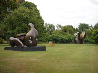
Some Henry Moore Sculptures, visible from the Public Footpath
SWC Walk 210 - Sawbridgeworth to Bishop's Stortfort (via Henry Moore Foundation)
Jul-19 • thomasgrabow on Flickr
swcwalks swcwalk210 walkicon 48223572642
![Henry Moore Sculptures on gate at St. Andrew's Church, Much Hadham SWC Walk 210 - Sawbridgeworth to Bishop's Stortfort (via Henry Moore Foundation) [Much Hadham Church Loop]](https://live.staticflickr.com/65535/48223511816_b1658642e2_n.jpg)
Henry Moore Sculptures on gate at St. Andrew's Church, Much Hadham
SWC Walk 210 - Sawbridgeworth to Bishop's Stortfort (via Henry Moore Foundation) [Much Hadham Church Loop]
Jul-19 • thomasgrabow on Flickr
swcwalks swcwalk210 walkicon 48223511816
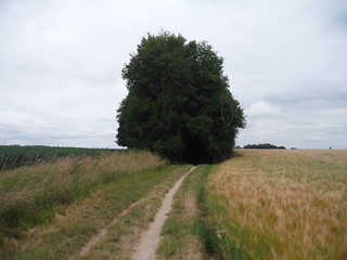
Brook Lane, Green Tye
SWC Walk 210 - Sawbridgeworth to Bishop's Stortfort (via Henry Moore Foundation)
Jul-19 • thomasgrabow on Flickr
swcwalks swcwalk210 walkicon 48223563337
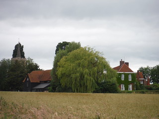
Thorley Hall and Church
SWC Walk 210 - Sawbridgeworth to Bishop's Stortfort (via Henry Moore Foundation)
Jul-19 • thomasgrabow on Flickr
swcwalks swcwalk210 walkicon 48223560067
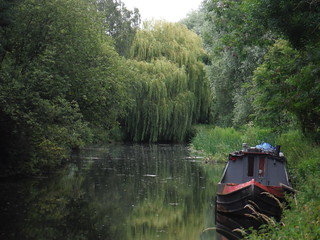
Willow and Barge, Twyford Bury, Stort Navigation
SWC Walk 210 - Sawbridgeworth to Bishop's Stortfort (via Henry Moore Foundation)
Jul-19 • thomasgrabow on Flickr
swcwalks swcwalk210 walkicon 48223500946


| Length |
23.8 km (14.8 mi), with 187/176m ascent/descent. For a shorter walk, see below Walk Options. |
|---|---|
| Toughness | 4 out of 10, with 5 hours walking time. For the whole outing, including trains, sights and meals, allow at least 8 hours. |
| Walk Notes |
After passing through the centre of Sawbridgeworth, much of which is a conservation area, this East Hertfordshire walk leads mainly through open countryside, either along tracks, green lanes or quiet country roads, providing extensive views across the gently rolling countryside of arable fields, woods and waterways.
The Henry Moore Foundation in Perry Green is passed in the morning. The walk features a substantially shorter version to enable an extended visit of the Henry Moore Sculpture Park, Studios and House. This version cuts out some of the most attractive parts of the walk, though. Note: The Henry Moore Foundation is usually closed from end October to Easter. |
| Walk Options | Bus 35/35C (Bishop’s Stortfort – Hertfort, broadly hourly Mon-Fri and two-hourly Sat) takes you from Much Hadham to either Bishop’s Stortford Interchange or St. Margaret’s Station (Hertford East line to Liverpool Street, run by the same train operating company).
Shortcuts: It is possible to shorten the walk in a further four ways:
Taking all shortcuts reduces the length of the walk to 16.1 km (10.0 mi), with a 1/10 rating. An optional loop through the historic centre of Bishop’s Stortford (1.6 km) passes many tea places and old buildings. |
| Maps | OS Explorer: 194 (Hertford & Bishop’s Stortford)
OS Landranger: 167 (Chelmsford) |
| Travel | Sawbridgeworth Station, map reference TL 490 150, is 6 km south of Bishop’s Stortford, and 48m above sea level. Bishop’s Stortford Station, map reference TL 491 208, is 43 km northeast of Charing X and 61m above sea level. Both are in East Hertfordshire. Sawbridgeworth Station is on the West Anglia Main Line from Liverpool Street to Cambridge (journey time from 36 minutes, up to three trains per hour) and also served by trains from Stratford (from 46 minutes journey time). Trains stop at Tottenham Hale (Victoria Line). Bishop’s Stortford is further down the line (journey time from 38 mins, with up to six trains per hour plus two to Stratford).
Saturday Walkers’ Club: Take the train closest to 9.30 hours. |
| Lunch |
The Hoops Inn Perry Green, Herts, SG10 6EF (01279 843 568). The Hoops Inn is located 7.5 km (4.7 mi) into the full walk and 6.8 km (4.3 mi) into it if taking Shortcut I. Currently closed.
|
| Tea |
Too numerous to list here, see the walk directions pdf for details. |
| Profile | |
|---|---|
| Help Us! |
After the walk, please leave a comment, it really helps. Thanks! You can also upload photos to the SWC Group on Flickr (upload your photos) and videos to Youtube. This walk's tags are: |
| By Train |
Out (not a train station) Back (not a train station) |
| By Car |
Start CM21 9JZ Map Directions Return to the start: Finish CM23 3BL Map Directions Travel to the start: |
| Amazon | |
| Help |
National Rail: 03457 48 49 50 • Traveline (bus times): 0871 200 22 33 (12p/min) • TFL (London) : 0343 222 1234 |
| Version |
Jul-19 Thomas G |
| Copyright | © Saturday Walkers Club. All Rights Reserved. No commercial use. No copying. No derivatives. Free with attribution for one time non-commercial use only. www.walkingclub.org.uk/site/license.shtml |


Walk Directions
Full directions for this walk are in a PDF file (link above) which you can print, or download on to a Kindle, tablet, or smartphone.
This is just the introduction. This walk's detailed directions are in a PDF available from wwww.walkingclub.org.uk