Bristol Harbour walk
Bristol's historic floating harbour via M-Shed, SS Great Britain, churches, galleries, museums, pubs and cafes

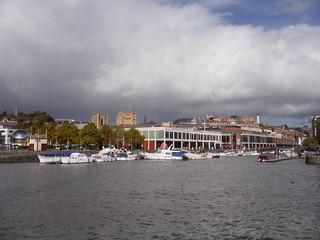
The Old and the New: Harbour Hub development across The Avon, with Cabot Tower on Brandon Hill in background
SWC City Walk 4 - Bristol Harbour
Oct-22 • thomasgrabow on Flickr
swcwalks city4 banner 52431595767

Curved Converted Warehouse on the Avon, by Castle Bridge
SWC City Walk 4 - Bristol Harbour
Oct-22 • thomasgrabow on Flickr
swcwalks city4 walkicon 52432551250
Waterfront Square and row of bars along inlet
SWC City Walk 4 - Bristol Harbour
Oct-22 • thomasgrabow on Flickr
swcwalks city4 walkicon 52432552425
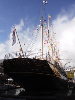
SS Great Britain Museum Ship (stern)
SWC City Walk 4 - Bristol Harbour
Oct-22 • thomasgrabow on Flickr
swcwalks city4 walkicon 52432374719

Grain Barge and houses on hillside
SWC City Walk 4 - Bristol Harbour
Oct-22 • thomasgrabow on Flickr
swcwalks city4 walkicon 52432101871
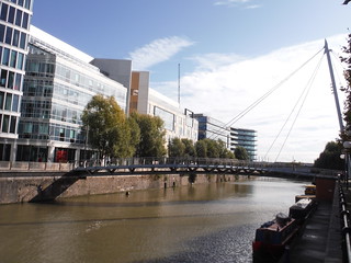
Valentine Bridge: S-shaped pedestrian bridge over The Avon, on Temple Quay
SWC City Walk 4 - Bristol Harbour
Oct-22 • thomasgrabow on Flickr
swcwalks city4 52432372734

Warehouse by bridge, River Avon
SWC City Walk 4 - Bristol Harbour
Oct-22 • thomasgrabow on Flickr
swcwalks city4 52432372924
| Start and Finish | Bristol Temple Meads |
|---|---|
| Length | 5 miles / 8 km |
| Time | 2 hours |
| Toughness | 1/10 |
| Walk Notes |
This walk loops around Bristol's historic sailing-ship era "floating harbour", passing new redevelopments, industrial heritage, and many tourist attractions, museums, bars, and cafes. Starting from the main station, the walk follows the meandering river / harbour through the town centre, past the old town to the historic era docks, which are now cafes and museums. Highlights include Queen's Square (Regency era), M-Shed (wharf turned into a museum), the Mathew (replic sailing ship), SS Great Britain (early metal hulled steam ship), Underfall Yard (lock gate engines) and harbourside bars and cafes.
|
| Walk Options |
This is one of 2 Bristol walks, the other is through the town to a weathly suburb, and the Clifton Suspension Bridge. You could combine them. |
| Eat/Drink |
Too many to choose from. Recommended is the Underfall Yard cafe, and the Pump House (pub), just across the lock gates. |
| Travel |
Trains from London Paddington to Bristol Temple Meads are 2 per hour, and take 1 hour 30 mins. £63 off peak. Slower but cheaper trains from London Waterloo via Woking and Salisbury are hourly (a few direct, most change at Salisbury), and take 3 hours. £41 off-peak. Consider Advance tickets. Beware of clashing with sports events (the Advance tickets will have sold out), especially on Saturdays. There are occasional special offers. By Car Bristol is in a Mon-Sat CPZ, so free parking outside the very centre on Sundays. Free parking anytime in the industrial area east of the station, or residential area (Totterdown) south of it (and the river), but on weekdays, commuters will have beaten you to it. Try Googling Bristol CPZ map. The SS Great Britain car park is good value at £5 for 5 hours (max). Clifton is in a weekday CPZ. There are no car parks, pay and display street parking is 5 hours max, but over the suspension bridge is outside the CPZ | ||||||||||||||||||||||
|---|---|---|---|---|---|---|---|---|---|---|---|---|---|---|---|---|---|---|---|---|---|---|---|
| Walks |
|


Walk Directions
- Exit Bristol Temple Meads station by turning right (north, signed "Temple Quay & Ferries", i.e. not the main exit with the roadway)
- Continue to a small square with a Wetherspoons pub off to your left (the meeting area for groups), with the river to your right.
- Follow the river. Turn left to along the riverside path, passing an S shaped pedestrian bridge.
- At the second road bride, cross to the opposite (north) bank and continue.
- Continue past Castle Green (remains of a castle and 2 WW2 bombed churches), and another S curved pedestrian bridge
- Continue to a road bridge, Bristol Bridge.
- Option: The old town is straight ahead / to your right. Turn right, along High Street, for the St Nicholas Market (covered market, food stalls, independent traders). Return to this point.
- Continue along the river as it veers left, now Welsh Back street. You'll have to leave the riverbank for a short stretch.
- Option: Turn right along pedestrian Kings Street for the historic 1664 Llandoger Trow pub.
- Continue to the end of the road, Queen's Square will be to your right.
- Rejoin the river. Follow it around the bend to a road bridge (or use the south side of Queen's Square instead, turning left at the end to rejoin the river)
- Option: Continue past the road bridge to The Arnolfini (art gallery, free).
- Cross the bridge south, over the big river towards M-Shed (museum).
- Turn right. Pass M-Shed (museum, free), and the disused cranes. Pass The Matthew (museum ship, free), a replica of John Cabot's ship used to (re)discover America.
- Just after M-Shed, go left, and walk out-back to see the cut (floating harbour bypass channel)
- Continue along the waterfront, pass the rail tracks and wagons
- Detour inland, around the SS Great Britain museum ship / Being Brunel museum. £18.
- Option: Continue ahead (inland) on the detour for the Spike Island Gallery (Wed-Sun)
- On the way back to the waterfront, opposite Force 4 Chandlery, on the corner of an industrial area is a white building with a clock. Down the alley to the side of it is a Banksy mural, "The Girl with Pearl Earrings".
- Go through Underfall Yard. There's a small museum (free, pump engines) and cafe with outside tables overlooking the river
- Continue. Turn right to cross the Avon on a road across the sluice gates of the Floating Harbour.
- Don't continue on to the end of the harbour (and outer lock gate), its a major road junction and wasteland.
- Head back to the centre, along the north bank.
- The riverfront turns a corner at a pedestrian square. There are many bars. Continue to the pedestrian bridge.
- Option: Turn left (away from the river) for Millennium square and the We Are Curious museum (kids science museum, free). By the large glitter ball is a big screen TV. Turn right at the start of the square, uphill, crossing, then up again for College Green and the Cathedral. Continue, and veer left for Brandon Hill (park) and Cabot Tower (free) you saw from the harbourside part of the walk.
- Option: Continue straight on to link with the Clifton Suspension Bridge Walk. As the road narrows after the end of the waterway, look up, and you'll see a series of murals on the drab 60's concrete buildings
- Cross the pedestrian bridge.
- Continue ahead, walk through Queen's Square (crossing your route out)
- Continue ahead, cross the river on a road bridge.
- Continue ahead at a roundabout with the large St Mary Redcliffe church (free) on your right
- Continue and Bristol Temple Meads is ahead.