The London Stations walk
All London’s railway terminals, the three royal parks, the River Thames and the City
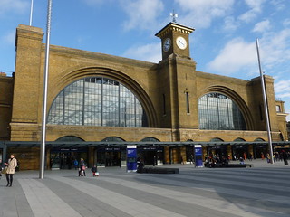
Kings Cross facade
Kings Cross to Liverpool Street walk
Feb-14 • Saturdaywalker on Flickr
swcwalk374 banner swcwalks 50956913142
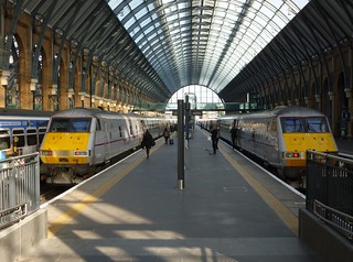
Kings Cross train sheds
Kings Cross to Liverpool Street walk
Feb-14 • Saturdaywalker on Flickr
swcwalk374 swcwalks walkicon 50956109148

St Pancras
Kings Cross to Liverpool Street walk
Dec-18 • Saturdaywalker on Flickr
swcwalks swcwalk374 walkicon 50956913742

Walking across to St Pancras
Kings Cross to Liverpool Street walk
Mar-20 • Saturdaywalker on Flickr
swcwalk374 swcwalks walkicon 50956913507

Paddington - roof detail
Kings Cross to Liverpool Street walk
May-04 • Saturdaywalker on Flickr
swcwalks swcwalk374 50956120073

The London Eye
Kings Cross to Liverpool Street walk
Apr-05 • Saturdaywalker on Flickr
swcwalks swcwalk374 50956889731

Destinations served from Blackfriars in Victorian times
Kings Cross to Liverpool Street walk
Jan-13 • Saturdaywalker on Flickr
swcwalks swcwalk374 50956277528
| Length | 21.3km (13.3 miles) for the whole walk, but it is easily split into smaller sections: see Walk Options below |
|---|---|
| Toughness | 1 out of 10 - entirely flat, but entirely on hard surfaces: definitely a walk to wear cushioned trainers and not boots. |
| Features |
This walk links (and in many cases passes through) all thirteen London railway terminals, and tells you something of their history along the way. But its attractions are not just limited to railway architecture. It also passes through the three main Central London parks - Regent’s Park, Hyde Park/Kensington Gardens and St James's Parks - and along the Thames into and through the City of London*. It takes in a surprising number of famous sights and a number of characteristic residential and business areas: in fact, if you are first time visitor to London, it is as good an introduction as any to what the city has to offer. Despite being a city centre walk, it spends very little of its time on busy roads, and has many idyllic spots in which to sit or take refreshment. In the summer months you can even have an open air swim midway through the walk in Hyde Park's Serpentine Lido. (* The oldest part of London, now the financial district. Whenever the City, with a capital letter, is used in this document, it has this meaning.) |
| Walk Options |
Being in Central London, you can of course start or finish the walk wherever you like, especially at the main railway stations that are its principal feature. However, just as a suggestion, the walk is split into three sections, each of which would make a nice afternoon outing: Kings Cross to Paddington: 5.6km (3.5 miles) - paragraphs 1-47 of the walk directions: This section takes in five stations, has Regent’s Park at its centre, and a canalside finish into Paddington. Paddington to Charing Cross: 7.2km (4.4 miles) - paragraphs 42-89 of the walk directions: A walk through Hyde Park/Kensington Gardens and St James Park, with a stretch of posh Belgravia in between. Charing Cross to Liverpool Street: 8.6km (5.3 miles) - paragraphs 87-161 of the walk directions: Along the river into the City, then up through the heart of the financial district, taking in seven stations and lots of other famous London sights. There is also a 0.7km (0.4 mile) extension to the walk - paragraphs 162-168 of the walk directions - taking in the former site of Broad Street station and London's "hidden" terminus of Moorgate. |
| Points of Interest | The many points of interest in this walk are covered in the text boxes in the walk directions below, so it is useful to refer to these even if you are doing the walk using the GPX. |
| Eat / Drink |
There are cafes, takeaways, restaurants and pubs throughout this walk - too many to list here. However, a few that are worth pointing out include:
The various cheap and authentic Indian restaurants in Drummond Street, just beyond Euston. The Garden Cafe in the heart of Regent's Park. Gino's Cafe Bar on the corner opposite Marylebone Station is one of the last Italian-run traditional cafes in London, a wonderfully efficient family-run business that produce immense English breakfasts in double quick time. The Lido Cafe by in Hyde Park: its glorious location right by the Serpentine, with lots of outdoor tables, make this seem like a little slice of the Mediterranean on a sunny day. St James's Cafe in St James Park: popular with tourists, it is nevertheless a great place to have tea. The quality of its hot food is a bit more variable. The Founder's Arms on the riverside just after Blackfriars station may be a completely modern pub, but its location across the river from St Paul's Cathedral gives it a wonderful view, and its food is good too. It has plentiful tables both inside and out, but they are always busy. The Bankers on the riverside near Cannon Street station: one of the City's "hidden" pubs. Borough Market, next to London Bridge station: London's foodie paradise, and a perfect place to get delicious takeaway foods of all kinds. |
| Further Reading | Cathedrals of Steam by renowned railway writer Christian Wolmar, detailing the history of the London railway terminals and the impact they had on the city, is the perfect way to find out more about the stations on this walk. A much smaller volume, but packed with interesting facts, is Discovering London Railway Stations by Oliver Green, former head curator of the London Transport Museum. I think I got my copy in the London Transport Museum bookshop. A big shout out too for London's Great Railway Century 1850-1950 by Keith Scholey. Very readable and not at all trainspotter-ish, this delightful book covers such essential topics as London's railway hotels, where the big freight yards were, the Middle and Outer Circle, and what some of London's terminals looked like when the first opened. Every household should have a copy... For those interested in the history of the railways in the south east of England, there is a railway history section on this website. Pages particularly relevant to this walk include Terminus Wars and London's Victorian Railways. |
| Profile | |
|---|---|
| Help Us! |
After the walk, please leave a comment, it really helps. Thanks! You can also upload photos to the SWC Group on Flickr (upload your photos) and videos to Youtube. This walk's tags are: |
| By Train |
Out (not a train station) Back (not a train station) |
| By Car |
Start N1 9AL Map Directions Return to the start: Finish EC2M 7PY Map Directions Travel to the start: |
| Amazon | |
| Help |
National Rail: 03457 48 49 50 • Traveline (bus times): 0871 200 22 33 (12p/min) • TFL (London) : 0343 222 1234 |
| Version |
Mar-24 Peter |
| Copyright | © Saturday Walkers Club. All Rights Reserved. No commercial use. No copying. No derivatives. Free with attribution for one time non-commercial use only. www.walkingclub.org.uk/site/license.shtml |

Walk Directions
- Start the walk in the plaza at the front (southern end) of Kings Cross station.
- The grandeur of the 1852 train shed designed by Lewis Cubitt is now once again fully visible, the cramped 1972 concourse that blocked the view of it having been cleared away. Before this, in Victorian times, there was an untidy clutter of buildings on this plaza, which was referred to in those less politically correct days as "the African Village".
- Go into the station to see the soaring beauty of the Victorian train shed, then turn left to come to the new concourse, opened in 2012 and looking from outside a bit like a flying saucer. Turn right to walk the length of the concourse and exit it in its top left-hand corner.
- If I have one criticism of this new concourse, it is that it makes little use of natural light. Even on sunny days the lights still have to be on. Original architect's drawings showed the roof as having more glass panels, but perhaps this would have made the concourse too hot in summer. In the top right corner is Platform 9 3/4, a magnet for Harry Potter fans which has long snaking queues day and night.
- Leaving Kings Cross brings you out a plaza, with St Pancras facing you.
- To your right (north) is the new district of Kings Cross Central - not on the walk route, but worth exploring. Under development since 2008, it was formerly the freight yards of Kings Cross, and includes many buildings from that time. If you want to have a brief look at it, turn sharp right up the main pedestrian route into the complex - King's Boulevard - and in 300 metres you come to Granary Square, with a fine complex of freight buildings in front of you, including the Granary itself flanked by the Eastern and Western Transit Shed (now Central St Martins art college), the Coal Drops to the left (now a shopping and restaurant area), and, just out of sight to the right of the Granary, the West Handyside Canopy under which fish and other perishable items used to be loaded into wagons (now a market/cafe area).
- Otherwise, cross the plaza towards the entrance to St Pancras station. Just before you go in, turn around to get the best flying saucer view of the new Kings Cross concourse. Once inside St Pancras, walk straight across it.
- This is the newer part of the station, added when services to Paris and Brussels were switched here in 2007. (See paragraph 96.) The extension doubled the station's length to accommodate the very long Eurostar trains, and provided platforms on the upper level for Southeastern High Speed and Midland services, as well as Thameslink down below you.
- Just before you exit the station by the glass doors on its far side, turn left down the central concourse to see the magnificent arched roof. It is worth taking escalator to the upper level (you will need to use the second set, in about 80 metres, the first set being down only) to see this in all its glory.
- This upper level is the original concourse level, the current concourse being in the former basement of the station, which was used for storing barrels of beer from Burton-on-Trent, one of the key sources of revenue for the Midland Railway, whose London terminus this was. The soaring arched roof over your head was the largest such structure in the world when the station opened in 1868. While on the upper level it is also worth going down towards the southern end of the station to see the statue of the poet John Betjeman, who was instrumental in saving the station from closure and demolition in the 1960s. Nevertheless, in the 1980s and 1990s St Pancras was a rather sad place, under-used and rundown. It was the Eurostar services that finally brought it back to its former glory. The magnificent clock at St Pancras is a copy. It is reputedly the largest station clock in Britain, with a minute hand over two metres long. But that did not stop British Rail selling it to an American collector in 1975, creating a plastic replica to put in its place. However, as the original was being taken down to be shipped, workmen dropped it and it smashed into pieces. Roland Hoggard, a signalman, bought the pieces and set about putting the clock back together in his garden in Leicestershire. This meant that in the early 2000s, when St Pancras was getting its current makeover, Dent & Sons, the original manufacturer, could be commissioned to make an exact replica, which is what hangs there today. In the pre-smartphone era people often arranged to meet under the station clock: the monumental sculpture of a canoodling couple - formally entitled "The Meeting Place" - is a nod to that tradition.
- If you have the time, go out of the front of the station using the archway under the clock (the original main entrance to the station), to see the grand gothic frontage of the Midland Hotel (a reworking of a rejected design for the Foreign Office) and the elegant vehicle ramp which curves up to it from Euston Road. All of this was designed to impress. The Midland Railway was a latecomer among Victorian railway companies in London, the flashy upstart entering a market already dominated by the Great Northern at Kings Cross and the London & North Western at Euston, so it wanted to make a statement. For the same reason, it was an innovator in passenger comfort, introducing dining cars and upgrading its third class to the same standard as second class on other railways, thereby abolishing second class entirely. It was also the first major railway company to allow third class passengers to travel on every train: other companies confined them to slow trains, reserving expresses for first and second class passengers.
- If you have walked all the way to the southern facade of St Pancras you could simply head west along the Euston Road to Euston. But a quieter route is to return to the new part of the station and exit through the doors on its eastern side. Cross the road and pass up a footpath to the left of the large modern building ahead.
- This building is the Crick Institute, opened in 2016 and bringing together Cancer Research UK, the Wellcome Trust, the Medical Research Council, and teams from Imperial College, King's College and University College into the biggest single biomedical research facility in Europe.
- Beyond the Crick Institute you come to a road. Turn left on this and then in 30 metres turn right through a gate into a housing estate. Pass through it to the other side, to emerge onto another road. (The gates to the housing estate seem to be always open, but if they are not, turn right on the road at the end of the path past the Crick Institute. In 70 metres turn left up Phoenix Road and turn left again at the next crossroads.) In 50 metres (130 metres if coming via the alternative route) you come to a vehicle-blocking barrier across the road. Here turn right up an unnamed pedestrian passageway.
- At the far end of the passageway you emerge onto a curve of road: take the road going up the left side of the curve (Doric Way, though not named here), ignoring a road full left. In 130 metres you come to a T-junction, with the warehouse-like side of Euston ahead. Cross the road and turn left on its far side. In 50 metres turn right up the steps into the Euston station complex.
- Carry straight on along the front of the station into a plaza full of picnic tables. Walk along the facade of the station until your way is blocked by construction hoardings ahead.
- This construction site ahead of you formerly contained two undistinguished 1970s tower blocks, which were demolished in 2019-2020 as part of works to create a new station for HS2, the high speed rail line to Birmingham and the North. Until plans for the station were thrown into doubt by prime minister Rishi Sunak in October 2023, this area was destined to contain a new Underground ticket hall with a direct passageway to Euston Square station, effectively combining the two Underground stations into one. Now it is not quite clear what the site will be used for.
- Just before the construction hoardings, turn right through the doorway into the station. Your onward route is to turn immediately left to leave the station by a side exit. But you might first want to go a little way onto the station concourse the read the next paragraph.
- Euston must be the most reviled station in London, though the author of this walk has to admit to a peverse fondness for it. If you step inside you will find a perfectly functional 1960s terminal (the somewhat clunky mezzanine was only added in 2016). The original 1837 station, London's first long distance terminal, was rebuilt between 1962 and 1968 as part of the modernisation and electrification of the West Coast Main Line. There was an outcry about the destruction of historic features of the old station - including the famous Doric Arch and a classically-styled Great Hall - and this caused to a sea-change in public attitudes to Victorian architecture that led to St Pancras, Marylebone and Liverpool Street all being saved from a similar fate. But in fact the Doric Arch would have had to be moved anyway, being sited roughly where the ticket barriers on platforms 8-10 are now. The old station facilities were too cramped for modern traffic levels and so the 1960s rebuild vastly expanded the station's footprint, gobbling up the former Euston Square in the process.
- Leaving the station by its side exit, as described above, you pass a Sainsbury supermarket on the right and beyond it a Caffe Nero. Just beyond the cafe you come to the extensive workings for the new HS2 station. Descend the steps and turn right to follow the hoardings northward for 70 metres, then left along a passageway across the centre of the HS2 workings.
- The Euston high speed rail station was originally planned to be built in two phases: six platforms on this site to coincide with the opening of phase 1 of the line to Birmingham, and then five more which would involve partially demolishing the existing Euston station to serve trains to Manchester and Leeds. In 2021 the government modified that to a single build station of ten platforms (which turned out to be more expensive than the two phase plan originally proposed...). Following prime minister Rishi Sunak's cancellation of the northern half of HS2 in October 2023, and his decision to only build the line from Old Oak Common in West London to Euston if private money funds it, the future of this site is unclear. However, you may notice that there are still construction workers on the site, completing aspects of the project that were too far advanced in October 2023 to not be completed. The original plans for the HS2 station also envisaged the rest of Euston being rebuilt eventually.
- Emerging from the HS2 workings, carry straight on down Drummond Street, which is famous for its cheap and authentic Indian restaurants. Cross the busy Hampstead Road and keep on westwards (still initially on Drummond Street, then Longford Street) until you come to a T-junction with the next main road, Albany Street. Cross this and turn right, then take the second left, Chester Gate, which takes you into Regent's Park
- Regent's Park was the idea of the Prince Regent, later George IV, but was originally envisaged as a development of fine houses and as a set piece to terminate the grand avenue of Regent Street and Portland Place. Construction of it started in 1816. As you walk through Chester Gate you can see some of the housing on the right, and there are also villas dotted about the park (see paragraph 27). The general public were not allowed into the park until 1835, and then only on two days a week.
- Passing through Chester Gate, cross the perimeter road (the Outer Circle) and enter the park proper. Take the path slanting right which brings you to the top of the formal Avenue Gardens. Here go right to the road and turn left on it to come to the Inner Circle. Cross straight over this and carry on through Queen Mary's Gardens.
- These gardens were only created in the 1930s: prior to that the area was a plant nursery. This section now includes a rose garden and the Regent's Park Open Air Theatre, which stages performances in the summer months.
- At the end of the gardens you have to go left a short way to come to the Garden Cafe, beyond which you turn right to emerge again onto the Inner Circle. Cross this and carry on down a path that merges with the shore of the boating lake.
- As you approach the lake, The Holme, one of the original park villas, is just about visible through the trees behind you - perhaps more so in winter than in summer. You get a better view of it from the far side of the lake. Until 2023 it was owned by the Saudi royal family but is now up for sale.
- Cross the footbridge over the neck of the lake, and exit the park by the Clarence Gate. Cross a minor road and turn right and then left to emerge onto Baker Street.
- The entrance to Baker Street Underground station is visible down the street. This is in some ways a "hidden" London rail terminus, since it has two terminating platforms as well as its four through ones, and acted as the West End terminus of many services of the Metropolitan Railway in the late Victorian era. Now these reach as far as Amersham, Uxbridge and Watford, but up to 1961 they also served Aylesbury and until 1936 the remote Buckinghamshire station of Verney Junction. We think of the Metropolitan as just another Underground line today, but in its heyday it had steam trains, dining cars and first class carriages, while the facilities at Baker Street included a tea room and the grand Chiltern Court Restaurant (now the Metropolitan Bar, a Wetherspoons pub). Had Sir Edward Watkin, chairman of the Metropolitan, had his way, the Great Central Railway (see paragraph 31) would also have terminated at Baker Street in a grand new joint station. But Metropolitan shareholders were too smart to link themselves to this no-hope project, and the Great Central was forced to build its own terminus at Marylebone.
- Just before you come to Baker Street station, turn right up Melcombe Street, which leads into Dorset Square. I suggest in the GPX that you walk around three sides of this square rather than just along its southern edge, because it is really rather charming. Either way, beyond it you come to Marylebone itself, with Gino's Cafe Bar a recommended old-style Italian-run London cafe on the corner to your left.
- Note the lovely covered walkway linking Marylebone to the hotel across the road - once the Great Central Hotel, now The Landmark, London. Note also how long the front of the station is. This was the last railway terminus to open in London - in 1899 - and despite serving the grandly named Great Central Railway, it was a hopeless venture. The London to Midlands market it was aiming at was already well served by services out of Euston, St Pancras, and Kings Cross, and right from the start its trains were lightly used. Its first three trains only had 53 passengers, barely outnumbering the staff, and in the early part of the twentieth century it ran just thirteen trains a day, seven of them expresses to Manchester. In 1966 it lost all services north of Aylesbury and in the 1980s it was proposed to divert High Wycombe line services into Paddington and restore Aylesbury to the Metropolitan Line. A closure notice for the station was issued in 1984, though rescinded in 1986 after fierce opposition. But after rail privatisation in 1996, Marylebone started to revive under the Chilterns Railways franchise. Services were started to Birmingham, using the old Great Western line to that city's Snow Hill station, and today Marylebone is finally a success story, albeit serving a somewhat different market from the one its founders intended.
- Walk in the main entrance of the station.
- Pause a moment to notice that the four platforms are ahead of you, and the rest of the concourse stretches away uselessly to the left. This is because the station was designed to have many more platforms. But only four were built and the land reserved for the others was later sold off. When the station wanted two more platforms in 2006, they had to be built awkwardly at the end of platform four.
- Turn left down the concourse, passing to the right of the Pret a Manger to emerge into a room at the end of the concourse with some historic photos of the station on its walls. This was the original ticket hall.
- Emerging from the station by the exit in front of you, turn right on the road. Take the next left, and at the crossroads go straight across Lisson Grove and on up Shroton Street. At the next junction turn left down Cosway Street, and then at the next crossroads go right up Bell Street.
- Follow this road until you emerge at the junction of Edgware Road and the Marylebone Flyover. Cross at the traffic lights, passing under the flyover, and turn right along the far side of the road, parallel to the flyover.
- The Marylebone Flyover is the start of the Westway, the elevated dual carriageway which carries the A40 out of London. When construction started on this in 1962, there was a plan called London Ringways, which was going to encircle London with four motorways - an elevated inner London box which would have ploughed through districts such as Camden and Islington, another on the route of the North and South Circular Roads, and two outer motorways. Roads like the Westway would have been the spokes of these wheels. But the construction of the Westway caused an outcry due to the way it blighted the urban communities to either side of it. This, and the projected huge cost, led to the Ringway scheme being scrapped in the early 1970s. Already constructed sections of the two outer Ringways were combined to make the M25 London Orbital Motorway, which opened in sections up to 1986.
- Take the next left off the main road and follow the buildings round to the right and left to come out onto the waterfront of Paddington Basin. Turn right along the water's edge.
- Paddington was not just a railway station: it was also a major freight hub on the Grand Union Canal. Up until the 1960s the whole area around you would have been filled with wharves and warehouses.
- Ignore the first footbridge across the water, but just after the basin turns right, cross the footbridge to its other side and turn right to continue in the same direction as before.
- Beyond the road bridge ahead of you, on the left-hand side of the basin, was the large goods facility of Paddington station, which was finally demolished in the mid 1980s. This was also the location of the passenger station from 1838 to 1854.
- 80 metres or so after crossing the footbridge, you come to one of the lesser-known entrances into Paddington station - leading to the Circle/Hammersmith and City Line platforms. Descend the steps and turn left past the Costa Coffee outlet (or if starting the walk here turn right after coming through the ticket barriers). Turn right onto the passenger footbridge just before the start of the arched roof. Follow this right across the station to platform one.
- Paddington is surely the most magnificent of all the London stations, and one of the finest works of the Great Western Railways founder and engineer, Isambard Kingdom Brunel. From the footbridge you have a grand view of the three aisles of the original station (a fourth, added between 1906 and 1915, can also be glimpsed at the start of the footbridge). Note the wonderful decorative detailing on the girders that hold up the roof. What is equally impressive is that this station is still pretty much as Brunel would have known it, yet continues to be a perfectly functional station for modern needs.
- Descend the steps at the end of the footbridge, and walk down platform one.
- Halfway along, look up to your right to see the amazing Moorish styling on the director's offices, which were positioned at the head of a cross-aisle to give a view of all the activities on the station. Platform one was originally the departure platform. You can see the former main entrance to this midway along it - now an exit to the Elizabeth Line (see paragraph 47). On the other side of the station, on what is now platforms 8 and 9, there was a taxi road to pick up arriving passengers. The ramp down to this can still be seen, descending from the footbridge you have just crossed, as can the exit ramp at the other end of the station, which is today the main pedestrian entrance.
- Coming off platform one at Paddington, turn right to exit the station just to the right of Sainsbury's.
- You now find yourself on the original entrance road to Paddington, where carriages, cars and taxis used to drop off departing passengers. To your right is the Elizabeth Line station, a rail project that created a west to east rail tunnel across London and opened in May 2022. Finding a place to build the Paddington station for this line was particularly problematic given the historical nature of the main line station, and so it was built in a deep trench. You can peer down into this from street level, but for a better look descend the first set of escalators. Note the glass roof above you as you do this, which is painted with fake clouds, presumably to make it look as if the station is open to the sky.
- Turning left up the entrance road from the main line station exit, walk away up the ramp, away from the Elizabeth Line station, to emerge at its top at a crossroads. Keep straight on down Spring Street.
- Where Spring Street ends at a T-junction with Sussex Gardens, turn right. Keep to the left-hand side of a big triangular intersection.
- In 80 metres or so, at a major road junction, keep straight on to pass to the right of the Royal Lancaster Hotel. In another 120 metres cross Bayswater Road and go through the gate into Kensington Gardens.
- Ahead of you are the Italian Gardens at the top of the Serpentine, the long lake through the middle of the park. You can go down either side of this, but the suggested route is to keep to its right-hand side.
- The Serpentine is technically only the part of the lake beyond the road bridge. The part you are now walking along is the Long Water, though this name is not in common use. The lake was created in 1730 at the request of Queen Caroline, the new bride of George II, by damming the Westbourne River. This river still exists, though hidden underground: it crosses Sloane Square Underground station in a large pipe which is visible from its platforms. These days the Serpentine is fed by springs, however. Kensington Gardens is usually lumped together with Hyde Park, which started life as a hunting ground created in 1536 by King Henry VIII. In 1637, with royal enthusiasm for hunting waning, the public were let in. In 1728 Queen Caroline turned this end of the park (the part to the west of the West Carriage Drive, the road that crosses the park from north to south) into the formal grounds of Kensington Palace, which was the main London home of the monarchs in those days, and which now houses lesser members of the royal family. Today the Gardens are still fenced, with the gates locked at dusk, whereas you can linger in the unfenced Hyde Park till midnight. In both cases police vehicles with searchlights come round to make sure the park is empty before it closes, but if you somehow manage to get stuck after dark in Kensington Gardens, the turnstile gate opposite Lancaster Gate station works in exit mode only at all hours.
- Keep to the path along the right-hand edge of the Serpentine, as it meanders in and out of shrubberies, giving views of the lake. Towards the end of Kensington Gardens, when the road bridge across the lake is getting close, be sure to fork left to pass under the bridge on a lakeside path.
- You are now in Hyde Park. In a hundred metres or so you merge with another path and pass the Princess Diana Memorial water feature on your right, and beyond that you come to the popular Lido Cafe, whose waterside tables are a pleasant place to sit with a drink.
- Just beyond the Lido Cafe is the Serpentine Lido, where you can swim in the summer months.
- The Lido was created in the 1930s, when swimming in the open air was all the rage, though I have read (I cannot now remember where) that in Victorian times men and boys used to bathe in the lake before midday, with respectable ladies for this reason keeping out of the park until the afternoon. The entrance to the Lido is in the small building on the right just beyond the cafe, and it is open from late May to September from 10am to 5pm. The water is obviously not chlorinated, but it is aerated, and is judged to meet bathing water standards even for children. (Nevertheless, the author prefers to keep his face firmly above water when swimming there...). You have the surreal experience of ducks and swans gliding serenely past you (or perhaps not so serenely: one imagines they are bit annoyed to have to share the lake with us). There is also a Serpentine Swimming Club, whose members are allowed to swim here year round from 5am to 9.30am: swimming in the Serpentine is otherwise against regulations when the Lido is closed.
- In winter, or after hours in summer, the gates of the Lido are open and you can walk through it along the lakeside. At other times you have to skirt round to the right of it on a path. Either way, beyond the Lido follow the edge of the lake to its end.
- A self-service restaurant visible to the left on the other side of the lake at this end serves more substantial food than the Lido cafe, but your onward route is to turn right here, downhill, away from the lake. Cross a pedestrian and cycle path (be careful here: this is a designated cycle route and cyclists pass at speed and rightly expect to have right of way), and then cross the wide sandy strip beyond.
- This sandy strip is Rotten Row, supposedly a corruption of "Route du Roi", the King's Road. This was the road from Whitehall and Westminster to Kensington Palace in the days when it was the main royal residence. In the eighteenth and nineteenth centuries it was also a fashionable place for the aristocracy to be seen riding. The road along the southern edge of the park, the South Carriage Drive, fulfilled the same function for those in carriages.
- Having crossed Rotten Row, carry on across the grass for 50 metres or so to come to a major path parallel to it, and turn left on this. At the next junction take the path to the right that brings you to the South Carriage Drive: cross this and exit the park by the Albert Gate.
- Cross the very busy main road of Knightsbridge and carry on down a side road, William Street, on the far side. This brings you out into Lowndes Square.
- Walk down the left-hand edge of the square, all the way to its far end. When you get there, slant left with the road you are on, ignoring roads left and right.
- In 200 metres, with a triangular garden ahead, fork left along Chesham Place. At the next junction, just after the end of the garden, turn right up Lowdnes Place. Ignoring two minor mews turnings to the left, you come to a crossroads with Eaton Place. Go left here.
- There were many attempts over the centuries to create housing estates for the wealthy in London. Quite a lot failed, some morphed into something else (eg Covent Garden), and a very few were a spectacular success. One such was Belgravia, where you now find yourself. Developed in the 1820s by the Grosvenor family, who in the previous century had turned an area of farmland into Mayfair, it was wildly successful, becoming the must-have address for the great and the good. Cannily, the Grosvenors kept the freehold of most of the properties, letting them out on long leases. They became incredibly rich and rose from being baronets to Dukes of Westminster. The Grosvenor Group still own many properties in the area, although the 1967 Leasehold Reform Act did weaken their grip a bit by giving tenants the right to buy. In the twentieth century Belgravia became popular with embassies and some of the houses were converted to offices: but quite a lot are still residential. In particular they are used as London bases by the global rich, which accounts for why many look unoccupied. For those on foot, Eaton Place is a slightly intimidating place, the five-storey houses seeming to look down with disdain on mere pedestrians.
- Keep straight on at the next crossroads, still on Eaton Place. At its end, turn right into Upper Belgrave Street. Keep straight on down this, crossing Eaton Square, and carrying on down Lower Grosvenor Street.
- Ignoring ways off, this brings you in the end to a T-junction with Buckingham Palace Road, on the far side of which is grand facade. This is what for most of its life was known as the Grosvenor Hotel - now The Clermont - which forms two sides of Victoria station but which is not visible from its concourse (though there is a rather inconspicuous entrance to it to the left of the ticket office).
- Cross Buckingham Palace Road and turn right. In about 50 metres there is a little-noticed entrance on the left that takes you into the station. You emerge a little way from the barriers platforms 15-19, serving Brighton and the South Coast. Turn left away from these and walk onto the main concourse.
- Victoria was originally not one station but two: an archway to link them together was only created in 1928, and the main departure board still mysteriously lists those of the "Kent side" in chronological order, and then those of the "Sussex side". The Sussex side, the one you are currently standing in, was the station of the London, Brighton & South Coast Railway and opened in 1860, while the Kent side belonged to the London, Chatham & Dover Railway and opened in 1862. They were the first railway lines allowed to cross the Thames. In Victorian times the two companies were known conversationally as "the Brighton line" and "the Chatham". This explains the exchange in Oscar Wilde's The Importance of Being Earnest when Jack Worthing reveals he was found as a baby in a handbag in the cloakroom on Victoria station. "On the Brighton Line", he adds helpfully. Lady Bracknell retorts "The line is immaterial!", but actually it was not. The "Chatham" was locked in an intense competition for Kent traffic with the Southeastern Railway, and was always a rather ramshackle outfit, infamous for delays and the poor quality of its carriages. The Brighton line had more cachet. From 1933 to 1972 the luxury Pullman train, the Brighton Belle, operated from this side of the station, while the Chatham side had continental boat trains to Dover, Folkestone and Newhaven from platforms 1 and 2. These included the Golden Arrow day train to Paris from 1926 to 1972 and the Night Ferry (a sleeper train whose carriages actually went on the ferry across to France) from 1939 to 1980. Boat trains finally ceased in 1994 when the Channel Tunnel opened. I have seen Victoria ranked as one of the least attractive of London terminals, but speaking personally I have the warmest affection for it, associating it with walks on the South Downs and summer trips to the sea. Like other stations on this walk - Charing Cross, Cannon Street, Fenchurch Street and Liverpool Street - it was given a makeover in the 1980s, with the space above the Brighton platforms turned into an office block and shopping centre (Victoria Place). For a long time it was the second busiest station in the country after Waterloo, but in the 2022-23 statistics it was relegated to fifth place, with Liverpool Street and Paddington taking the top two slots due to the Elizabeth Line, and London Bridge squeaking past it to take the number four slot.
- On the main concourse, turn right past the entrance to platforms 9-14 and at their far end keep straight on down a passageway into the Chatham side of the station. Turn left here, walking away from platform eight and with platform seven to your right.
- The thing to notice here is the original 1862 roof, which was restored in the early 2000s. Not grand or impressive, but a workable piece of Victorian engineering that has lasted for over 160 years.
- Keep straight on to exit the station by its arched entrance. Cross the plaza and carry straight on across the edge of the bus station.
- When it is safe to do so, turn around to look at the facade of Victoria station. You can see the two different architectural styles of the two stations. The Chatham facade was only added in the early 1900s. Before that there was just a jumble of shed-like buildings in front of the arches. (As mentioned above, it was not a wealthy railway company.)
- 40 metres beyond the end of the bus station, turn right to cross two busy roads at the traffic lights (Wilton Road and Vauxhall Bridge Road, though not named here) and carry on beyond up Victoria Street. In 50 metres more, just after a side road to the right, turn left to cross Victoria Street at the traffic lights and on the far side slant right into the modern Cardinal Place shopping centre. In 100 metres, in the main plaza of the centre, turn half left, passing to the left of a set of escalators in 40 metres. Carry on up a broad paved walkway to emerge in another 170 metres on Palace Street. Cross this and go straight ahead up Stafford Place. In 100 metres, near its top, take an alley to the left to emerge onto Buckingham Palace Road.
- The building ahead of you is indeed Buckingham Palace, though you are seeing it from the side. Note the Queen's Gallery (soon to be renamed the King's Gallery?) where the monarch shows off his artworks in public exhibitions. Buckingham Palace is so intimately associated with royalty that it is a surprise to learn that it has only been the main London residence of the monarch since 1837, when Queen Victoria adopted it as such. For much of the Hanoverian period, as noted above, the principal royal residence was Kensington Palace. Victoria had been brought up there and kept under a very strict regime (she had to sleep in the same room as her mother even when a teenager, and hold a servant's hand when walking down stairs), which probably explains why she did not want to live there as an adult. Buckingham Palace originated as Buckingham House, built by the Duke of that name in 1703, one of many grand aristocratic houses that were built around Green Park (several of which still exist - for example Lancaster House and Spencer House). The Buckinghams were famously bad at managing their wealth, however, and sold the house in 1761 to George III, who used it as a residence for his wife Charlotte. That house was much smaller than the one you see now. Modifications and extensions started under George IV in the 1820s, and further additions and alternations were made in Victoria's reign. These included the East Wing, the public facade today, with its famous balcony from which the royals wave on important occasions, which was built between 1847 and 1850.
- Turn right on Buckingham Palace Road. (Unless you want a closer look at the palace, it is better to not to cross the road but to stay on this side). Once you have passed the palace, cross Buckingham Gate and keep straight on with a large triangular road layout to your left. In 150 metres, at the end of this, turn left to cross the road at the traffic lights and go straight on into the park. Take the path that forks right, pasing a playground. You soon have the lake on your left-hand side.
- St James's Park (note the double s and apostrophe! Don't you dare write St James Park...) has a complicated history dating from the 1530s, but the way it looks today is largely due to George IV. George was grossly overweight (his official portraits are all flattering and even in them he looks extremely rotund) and widely regarded in his day as a glutton, spendthrift and generally discreditable character. Had the monarchy not been saved by Queen Victoria, we would probably now be a republic. But what he did have was excellent taste, and this charming park is a credit to him and his landscaper, John Nash. The feature of the park I like the most are the magnificent London plane trees. A chance hybrid between the American sycamore and the Oriental plane, this species was discovered in the 17th century and widely planted in the 18th. It is the classic London tree, found everywhere in the city and famously resistant to Victorian soot and grime due to its habit of shedding its bark. In more modern times it has been proved that its leaves cool and clean the air. The ones here have grown to an immense height and provide wonderful shady canopies to sit under on hot sunny days (and yes, London does have some).
- You can stay on this path all the way to the end of the lake if you like. The park is nearly always busy with tourists and this side of the lake is perhaps a little less busy than the other. Having said that, it is worth crossing the bridge halfway along the lake for the fine view towards Buckingham Palace one way, and towards Whitehall and the London Eye the other. If you do this, then turn right beyond the bridge onto the path along the northern side of the lake.
- This path along the northern side of the lake soon takes you past a place popular with bird feeders, where you can see the amazing variety of waterbirds found in the park. Information panels identify them, but my two favourites are the Egyptian geese (actually more closely related to shelducks), whose eye patches make them look as if they have been in a fight. Fitting in with this image, they can indulge in very noisy bouts of competitive honking (which sometimes are actually a sign of affection - it seems to be one way that the birds form pair bonds). You might asssume they are a modern introduction, but they have in fact been here since the late 1600s. They are now apparently quite rare in Egypt. My other favourite is the cute little tufted duck. I just love to think of all those countless eons of evolution that led to the creation of that little tuft - and to speculate in what way it helped tufted ducks survive in their natural habitat. Ducks are either dabblers or divers, and the tufted duck is a diver. It is sitting on the water, apparently serene and then - plop - it has gone. Feeding bread to the ducks, incidentally, is not good for their insides. Numerous studies have established this and signs in many parks urge you not to do it. But good luck trying to tell that to anyone.
- Just beyond the lake on the northern side is the St James's Cafe, a nice place to have tea, with outside and inside tables. It also does hot food, though the quality of this is a bit variable.
- Whichever side of the lake you have walked on, keep straight on to come to the end of the park and Horseguard's Road, with the big gravel expanse of Horseguard's Parade beyond. Assuming no event is taking place, carry on straight across it. If for any reason you can't cross the parade, turn left up Horseguards Road and then right at the T-junction with the broad avenue of The Mall to exit the park through Admiralty Arch: this brings you to the junction at the top of Whitehall mentioned in paragraph 84.
- Horseguard's Parade is where the Trooping of the Colour takes place, a military parade to mark the monarch's official birthday - not his actual birthday, but a day in June selected to celebrate his accession to the throne. In medieval times this was the tiltyard of Whitehall Palace, where jousts and tournaments were held. The building on the left-hand side of the parade ground is the Old Admiralty - the historic headquarters of the navy - and on the right-hand side you can see the garden walls of the houses in Downing Street, including the back garden wall of 10 Downing Street, the prime minister's residence. The building ahead (or a predecessor) was an entrance into Whitehall Palace, which was the main royal residence until it burnt down in 1698. After that the court moved to St James's Palace, just to the north of the park, so the guards turned to face in the opposite direction. Today the gateway is guarded on the Whitehall side by Queen's Life Guards, who may be there on horseback or on foot, and whose barracks are on the south side of Knightsbridge. In these terrorist-prone times there are usually a couple of heavily armed policemen guarding the guards.
- Go on through the arched gate of Horseguards and the courtyard beyond to emerge into Whitehall (the street).
- As mentioned above, Whitehall was once Whitehall Palace, the main royal residence and the largest and most complex palace in Europe. It burned down in January 1698 because a maidservant hung wet linen to dry around a charcoal brazier (what happened to her afterwards is not recorded...). The fire raged for 15 hours, and when it was finally controlled, another broke out, eventually gutting the whole complex and destroying artworks including a sculpture of Cupid by Michelangelo. The only building of any note to be saved was the Banqueting House, which is on the other side of the road, to the right of the side road, as you exit Horseguards. It is open to the public, but apart from its lofty interior there is not much to see. It was through a first floor window in this building that Charles I was led to be beheaded for treason on 30 January 1649. Whitehall is now the centre of British government, lined with ministries such as the Ministry of Defence, the Foreign Office, the Treasury and the Cabinet Office.
- Turn left up Whitehall and walk to its top. Trafalgar Square and Nelson's Column are in front of you.
- Nelson's Column is so famous and familiar that you have probably never stopped to think how odd it is that he is standing on a pillar. But when the monument was new in 1843, people thought it very strange. Why was it designed in this way? The problem was that Trafalgar Square is so big that a mere statue of a man would be lost in it, while one big enough to notice would be ludicrously large. The column was the answer, but it means that the details of the statue itself are impossible to see. One detail that was criticised by contemporaries is that Nelson is wearing a hat: in his lifetime he was nearly always bare-headed, unusually so for his day. Had Hitler conquered Britain he had plans to take Nelson's Column back to Berlin, where it would have become the centrepiece of a plaza in his rebuilt capital, Germania.
- Facing Trafalgar Square at the top of Whitehall, ignore the first road right (Northumberland Avenue), but carry on round to the next road, the Strand. Walk along this to find Charing Cross station on your right.
- Pause before you go in, to notice the facade of Charing Cross, which is a hotel. Also the replica medieval cross which stands in its forecourt. Charing Cross is named after this cross, which was one of a series put up by Edward I to mark the places where the coffin of his wife Eleanor rested on its way from the East Midlands to Westminister Abbey in 1290. (Waltham Cross, just north of London, is another of these, and one of the original crosses survives there.) It is from Charing Cross that all distances to London in road signs are measured.
- Walk through the arch onto the station concourse and stand in its centre.
- Charing Cross station was opened in 1864. When the London, Brighton & South Coast Railway and the London, Chatham and Dover Railway were allowed to open stations north of the river at Victoria in 1860-62, the Southeastern Railway, whose terminus was at London Bridge, was very keen to follow. Charing Cross was the result. It once had a fine arched roof, but on 5 December 1905 there was an ominous crack and the station was evacuated. Twelve minutes later the roof collapsed, killing six people (two workmen on the roof, three nearby and a bookstall vendor on the concourse). A ridge and furrow roof was built instead. In 1986 the section of the roof over the platforms was taken down and the Embankment Place office complex was built over it - part of an initiative by Margaret Thatcher's government to monetise the airspace over mainline railway stations (as also happened at Victoria, Cannon Street, Fenchurch Street and Liverpool Street). In Charing Cross's case the result is not unattractive, and it is in general a very pleasant little station, modest in scale, usually not over-busy, and serving some nice country walking destinations. The Southeastern Railway also deserve credit for enabling both the West End (via Charing Cross) and the City (via London Bridge) to be served by the same trains - a neat solution that no other rail company achieved. One last thing to do before you leave Charing Cross is to turn around and look above the ticket office. Here you see a no longer used balcony of the Charing Cross Hotel. Once this was one of the most fashionable places in London. In those days Southeastern competed with the London, Dover and Chatham Railway to offer boat train services to Dover and Folkestone. Travellers set off to the Continent from here, and sitting on the balcony with a glass of wine you could keep track of all the celebrities coming and going.
- Leave the concourse of Charing Cross by the small exit just to the left of platform one. Go down the long flight of steps and turn right onto Villiers Street. Just before the entrance to Embankment Underground station, turn right under the railway bridge. On the far side, turn left up the steps onto the footbridge leading over the Thames. There is a fine view from this of the Houses of Parliament, Westminster Bridge and the London Eye (see below).
- The railway bridge to your left, leading out of Charing Cross, is Hungerford Bridge. What you see today is a typically sturdy piece of Victorian engineering, whose girders and struts have put up uncomplainingly with nearly 160 years of heavy trains thundering across them. (I love the way the bridge vibrates slightly when they do this.) This is actually the second bridge on this site. The original was an elegant suspension bridge - for pedestrians only - designed by the famous engineer Isambard Kingdom Brunel and opened in 1845. It served Hungerford Market, which was where Charing Cross is now, but was only in use for 18 years before it was bought by the railway company and dismantled. Brunel's bridge was not entirely lost however. The sturdy brick piers on which the two towers of the suspension bridge were built were incorporated into the new bridge, as you can see. If the northern one looks closer to the shore than the southern one, that is because the Victoria Embankment, built in 1870, narrowed the river. The chains from the old bridge were re-used on the Clifton Suspension Bridge in Bristol, which had been designed by the great man but which was not completed after his death. Two walkways - one on either side - were also provided alongside the railway bridge to replace the lost footbridge. The upstream one (the side you are now on) was later removed when the railway was widened, but the downstream bridge continued in use throughout the twentieth century. It was quite narrow, however, and in the 1990s was becoming inadequate for amount of people crossing, so as the millennium (the year 2000) approached, a competition was held to create the current pair of footbridges. Officially the Golden Jubilee Bridges (though most Londoners just say "Hungerford Bridge"), these opened in 2002, letting us see the upstream view again. Though they seem to be attached to the Victorian bridge, they are structurally quite independent and could apparently withstand a major collision with a ship. While on the bridge, turn around and glance back towards Charing Cross. You can now see Embankment Place, the office block that was built over the station's platforms in the 1980s. Note that it was given a curved roof, a tribute to the arched roof that Charing Cross lost in 1905 (see paragraph 89 above).
- Walk to the southern end of the bridge and go down the steps onto the riverside walkway.
- From here there is a wonderful sideways view of the London Eye, the outsized observation wheel that was put up in 2000 to celebrate the millenium. It was only supposed to stay in place for five years. At 135 metres in height, it was the world's tallest ferris wheel when erected, but has since been surpassed by ones in Nanjing, Singapore and Las Vegas. It is worth pointing out that while the legs seem to be holding the wheel up, it is in fact the cables going down to the ground behind them that stop it falling down, the legs just acting as a fulcrum. When the Eye was being erected, it was carried down river laid flat on a barge and then winched up to a 65 degree angle, where it hung for several days - a memorable sight.
- Walk towards the London Eye until a park opens up on your left. Take the curving path that crosses the park, taking you away from the river.
- On the far side of the park you come to a road. Cross this and turn left. In 30 metres turn right up a pedestrian route between tall buildings. In 80 metres turn left on a main road, passing a tube station entrance, to come to the pedestrian lights just before a railway bridge. Turn right across the road here and follow the approach road up towards the Victory Arch entrance (a First World War memorial) to Waterloo station. Climb the steps onto the concourse.
- The first thing to notice is the magnificent curved glass roof over platforms 20-24. This was the original Eurostar terminal, a beautiful piece of architecture but a poor piece of planning, since it was only in use from November 1994 to November 2007, at which point services moved to St Pancras. The reason for the move was that in the run-up to the opening of the Channel Tunnel there was widespread disagreement about the route of the planned high speed rail line from it to London. Waterloo had been chosen to be its terminus, but residents in South London, Surrey and Kent objected to the idea of the line passing their houses. So after travelling at 180mph from Paris and at 130mph through the tunnel, the trains slowed to what seemed like 60mph (probably more like 90mph), as they trundled along existing lines into Waterloo. Only the fine station at this end mitigated the national embarrassment. The solution finally adopted was to build a high speed line along the M20 motorway and through the former docklands areas north of the Thames, ending up with a tunnel to St Pancras, then a rather shabby and under-used station. The line was built in two phases, part one opening in 2003 and the second in 2007. Once services had moved to St Pancras, the Waterloo Eurostar terminus lay derelict, with no decision taken about its future, until in 2016 it was decided to integrate it into the rest of the station. This work was finally completed in May 2019. The area under the platforms, the former Eurostar check-in area - has been converted into The Sidings, a shopping and restaurant area. At time of writing (Feburary 2024) it is still largely empty and is consequently a rather eerie place to explore. At its far end is a little known entrance to the Underground platforms, and up onto the main line platforms above. The shopping centre even has an even less visited lower floor.
- Facing the former Eurostar terminal, turn right along the concourse of the station, perhaps even going up onto the mezzanine level, added in 2012, for a better view. Going up the first, backward-facing, escalator is particularly recommended: from its top you get a magnificent view of the former Eurostar terminal, the main concourse and the main trainshed.
- Waterloo was for a long time Britain's busiest station, beating second-placed Victoria by some margin. But in the 2022-23 statistics it was surpassed by both Liverpool Street and Paddington due to the opening of the Elizabeth Line, which counts as a national rail line despite being more than a little metro-like in character. Waterloo is still the country's largest station in area, however, and has the most platforms. Apart from its main pedestrian entrance being rather oddly tucked away at one end of the concourse, it is the best laid out of all the London terminuses too. It may not be that spectacular architecturally, but is easy to navigate and it has all the facilities a major station needs. Most passengers using it never give it a second thought, and that is its great glory. This was not the case in Victorian times, when Waterloo was a notorious mess. The London & South Western Railway originally terminated at Nine Elms, which had been chosen in 1838 for its proximity to the freight services of the river (it later became the company's freight station and survived in this role till 1968, when it was demolished). Waterloo opened in 1848 but was supposed to be just a stop on the way to the City. That onward connection failed to materialise, but the station did get a link to Waterloo Junction (now Waterloo East) when the Southeastern line to Charing Cross opened in 1865. For a year or two the LSWR ran trains into Cannon Street, but that proved unworkable, and instead trains terminated at Waterloo and passengers had to change. Over the years other platforms sprouted on either side of this line, until by the late Victorian era Waterloo had separate central, south, and north sets of platforms, each with their own ticket offices. Jerome K Jerome memorably satirises this in chapter five of his comic novel Three Men in a Boat, when the three heroes wander hopelessly around the station trying to find the train to Kingston. They finally bribe an engine driver to take them there, later discovering that his train was supposed to be the Exeter Mail. Finally, in the 1890s the LSWR gave up trying to get to the City. Instead they built the Waterloo & City, only the second tube line in London, which opened in 1898 and remained in British Rail hands until 1994. They also decided to rebuild Waterloo. Work started in 1900, and though part of the new station opened in 1911, it was not until 1922 that the whole thing was finally complete. Admittedly, the First World War had slowed work a bit, but it still shows that it is not only in the modern era that railway construction projects take decades. In this case, it was worth the wait.
- Walk half way down the concourse until you come to the huge clock (an important meeting point in the pre-smartphone era). Turn left here to exit the station by the entrance to the left of Costa Coffee. (This exit was built to enable vans carrying newspapers and parcels to enter and leave the station). You emerge onto the taxi ramp of Waterloo.
- Train station history nerds might like to go to the back of the cycle racks and turn right for 50 metres until you come to two stone portals on the left, with closed shutters that you can just about see through. Here you can see the bridge that used to carry the rail link to Waterloo East. It is now used for storage, with the passenger footbridge to Waterloo East visible above it.
- To continue the walk, turn left (or turn right if coming from the cycle racks) and walk all the way down the taxi ramp. At the bottom cross a busy road (York Way), and beyond continue on the broad pedestrian route that slants under a railway bridge and brings you out behind the Royal Festival Hall.
- The Royal Festival Hall is all that remains of the Festival of Britain, which was held on this site in 1951. Designed as a morale booster after the Second World War, and a showcase for British arts, design, architecture and science, the festival started the transformation of an area formerly known for warehouses and working class housing into the South Bank. One of the great novelties for visitors to the event was having a traffic-free place to sit and relax by the river, something we now take for granted. Today the area is a culture hub that includes the Hayward Gallery, British Film Institute and National Theatre, as well as the concert hall complex of the Royal Festival Hall, Queen Elizabeth Hall and Purcell Room.
- Cross the road in front of the Royal Festival Hall and turn right along its front, then turn left beyond it to come to the river.
- Notice as you walk past the side of the hall to the river that there is a little-used entrance to it here. This was intended by the architects to be the principal way in to the complex: these days most people would consider the main entrance to be from the mezzanine level on the river side.
- Once on the river bank, turn right and follow the path along the edge of the Thames under Waterloo Bridge.
- The next stretch of the riverside, with benches under trees, is a popular place to sit and chat. It is particularly attractive towards dusk in the summer, when the setting sun bathes it golden light, or after dark, when there coloured lights in the trees (set up many years ago as Christmas lights and never removed). Towards the end of this terrace is a fine view of the City skyline. As well as using it for the cultural hub, Londoners also use the term "South Bank" to refer to this riverside walk, but the official name (referring to the whole route from Lambeth Bridge to Tower Bridge) is Queen's Walk, this name being given to it when it was created in 1977, the year of the Queen's Silver Jubilee. The fact that this royal name did not really catch on sets the mind to musing on other examples. The Golden Jubilee Bridges (aka Hungerford Bridge) are mentioned above, and just after Waterloo Bridge you pass on the right the National Theatre, which is technically the Royal National Theatre, having been granted permission by the Queen to use that prefix in 1988, but which has largely ignored it ever since. Much further downstream, and outside the scope of this walk, the Queen Elizabeth II Bridge that carries the M25 motorway southbound over the River Thames is universally referred to as the Dartford Bridge, or together with its associated tunnels as the Dartford Crossing. Beyond the section under the trees, notice the Oxo Tower on the right-hand side of the river. Converted into a cold store in 1928-9 from an early Victorian building, its owners, the Leibig Extract of Meat Company, wanted to include on the tower a neon sign advertising its most famous product - Oxo stock cubes. When this was refused, the tower was designed with windows spelling out the brand name. The building was nearly demolished in the early 1980s, but was saved by the Coin Street Community Development initiative. It now houses shops, flats and - on its top level - restaurants.
- Carry on along the river path to the left of the Oxo Tower and beyond past Sea Containers House (once offices, now a hotel) to Blackfriars Bridge. Use the tunnel to pass under the first bridge, a road bridge. Note the murals in the tunnel showing the construction of the original bridge, and one including an early version of Blackfriars station.
- There were once three Blackfriars Bridges, and the red columns that supported the second can be seen beyond the tunnel under the road bridge. This was the original railway bridge, opened in 1864, and by 1865 the line over it linked up to the Metropolitan Railway at Farringdon, creating a cross-London railway line which is now used by Thameslink. In the Victorian era this line was extremely popular for both passengers and freight, with all sorts of railway companies using it. The route was so popular, in fact, that the London, Chatham & Dover Railway (whose crest you can still see on the bridge), built a another railway bridge alongside it, the one the station is now on. Freight traffic continued until the 1960s, but after that usage of the older bridge tailed off. By 1985 it was considered too weak for modern trains and its deck was removed. However one of the three sets of columns for each pier was re-used in the revamp of Blackfriars station in 2009 (see below)
- Pass under the railway bridge, to find yourself by the southern entrance of Blackfriars station. You can either walk through the station concourse or take the passageway passing to the left of it. Beyond you have a good view of the station on its bridge.
- Blackfriars station has a complicated history. You will recall that one of the two stations at Victoria was owned by the London, Chatham & Dover Railway. That gave them access to the aristocratic West End, and Blackfriars was their attempt to also get access to the City of London. The original station - the one you can see an image of in the foot tunnel under the road bridge - was on the south side of the river, opening in 1864. But as soon as the rail bridge over the Thames was built, the company built a second station north of the river. Called Ludgate Hill, this was situated roughly where the southern entrance of City Thameslink is today. Other rail companies also rushed to use Ludgate Hill, which only had two through platforms and soon became congested, so in 1874 the LCDR built a third station, Holborn Viaduct a bit to the north of Ludgate Hill. This had six platforms, a grand hotel, and was for exclusive LCDR use. Later, in 1886, it built the second railway bridge, the one in use today, and on the north side of that created yet another station, called St Paul's. At the same time it ceased passenger services to the original Blackfriars station south of the river: it became a freight terminal, in which role it lasted until 1965, after which it was demolished. Ludgate Hill was always a commuter station, but trains to Kent and the Channel ports departed from Holborn Viaduct and St Paul's. If you cross the river to the northern concourse of the current Blackfriars station, you can see original brickwork from St Paul's station, promising services to Bremen, Brundisi and Berlin in the same breath as Bickley, Broadstairs and Canterbury. In the twentieth century, however, both Holborn Viaduct and Blackfriars declined into commuter stations. Holborn Viaduct was badly bombed in the Second World War, and was finally demolished in 1990 as part of the creation of Thameslink: the northern exit to City Thameslink station comes out on its former site. St Paul's was renamed Blackfriars in 1937. Whatever it had been in the past, by the 1980s and 1990s Blackfriars was a rather unglamorous place. It had three terminating platforms and two through lines which served Holborn Viaduct, and later Thameslink. But from 2008 to 2011 it was totally rebuilt as part of the upgrade to Thameslink services. To enable them to cope with twelve-car Thameslink trains, the platforms were put onto the bridge itself. The station now has two through lines and two terminating ones (the latter having been moved from the east side of the station to the west, hence to need to use some of the demolished bridge's supports), and - for the first time - an entrance on the south side of the river. It gets much of its power from solar panels on its roof. The views from the platforms are glorious, particularly the view eastwards towards the City from platform one. If you don't have a travelcard, travelpass or season ticket to give you entrance to the station, I am told that you can buy a platform ticket for 10p from the ticket office. You could then also walk across the bridge to the main, northern entrance to the station, but truth to tell, apart from the old brickwork with station names mentioned above, there is not much to see there. One final thought is whether Blackfriars qualifies as a terminus station at all. At present only the twice hourly Sevenoaks services start from here: all other Thameslink services (to Brighton, Horsham, Rainham, Bedford, Peterborough, Cambridge) run right through the heart of London on Thameslink. Pre-Covid the plan was to join the Sevenoak services up with Great Northern services to Welwyn Garden City to make another through route, but currently this only happens in the Monday to Friday rush hour.
- From Blackfriars, carry on east along the riverbank, passing the Founders Arms pub - a good place for a riverside drink or meal, if you can squeeze into its always busy tables - and beyond it the massive Tate Modern art gallery on your right, the Millennium Bridge (a metal footbridge), and then Shakespeare's Globe.
- The transformation of this stretch of river since the 1990s is extraordinary. The Founder's Arms used to be one of the author's little secrets - set in a run-down area that few Londoners knew about or visited, but with a fine view of St Paul's. The building that houses the Tate Modern - the former Bankside power station - was derelict, with broken windows and generally considered to be a major eyesore. It was the second power station on this site, the Victorian one being rebuilt after the Second World War and converted from coal to oil-firing. The oil was delivered by barges to the jetty which is now a stop for the Thames Clipper. It seems extraordinary these days that a power station belching fumes could be sited in the heart of the city, but Bankside was once a string of such facilities, others being sited in Battersea and Greenwich. It ceased generating in 1981 and in the late 1990s was transformed into the modern art gallery you see today: entrance to this is free, so you can go inside and see the vast former turbine hall, if you wish. The Millennium Bridge was, as its name suggests, another part of London's celebration of the year 2000. It was nicknamed the "Wobbly Bridge" on opening, because pedestrian footfall on it created an alarming swaying motion. This was soon fixed by dampers, and today the bridge provides not just a good view downriver to the City, but a wonderful photograph of St Pauls. Shakespeare's Globe is an exact replica of the theatre in which Shakespeare wrote many of his plays - it even used authentic Elizbethan building techniques. It was the brainchild of Sam Wannamaker, an American actor and director, and father of actress Zoe Wannamaker. He first came up with the idea in the 1970s, and it met with considerable disdain from the British establishment, who regarded it as a rather crass American idea and said it would not meet modern safety standards. Even Wannamaker had doubts that the theatre would be successful as a performance venue, and so made it part of an exhibition into Shakespeare's life and times. He sadly died in 1993 without seeing the project completed. Once the theatre opened in 1997, it was a roaring success and is now widely acknowledged to have introduced a whole new perspective into our understanding of Shakespeare. The actor Mark Rylance, who was artistic director until 2006, was particularly influential, staging productions in Elizabethan dress and using all the theatre conventions of the time, including finishing the plays by having all the cast dance in front of the audience.
- A little way beyond the globe you come to Southwark Bridge. Ignore the steps up to it on this side of the bridge, but go through the pedestrian passageway under it and turn left back to the river beyond it. Climb the steps you find here up onto the downstream side of the bridge, and walk across it.
- Southwark Bridge is London's "forgotten" river crossing. It has the least traffic of any of the capital's Thames bridges, presumably because the road connections either end are not so convenient. It first opened in 1819, though the current structure dates from 1921. It gives a good view of Cannon Street station across the river - though it is a rather sad sight. This was another station that had offices built over its platforms in the 1980s, but they sit awkwardly between its Victorian walls and towers. It is a commuter station today, serving destinations in South East London, but when it opened in 1866 it was a much grander affair. This is in fact the City sister of Charing Cross: like that station it had an arched roof and was fronted by a grand hotel. Trains departed from here to Dover, Folkestone and the far reaches of Kent: in fact until 1916, all long distance trains from Charing Cross came here first, and then reversed out to London Bridge, something that contributed to the Southeastern Railways' poor reputation for punctuality. The link line from Charing Cross (which still exists) thus had a regular train service, which for a few years (until the District Railway opened in 1871) provided the quickest way from the West End to the City. This was very well used by Londoners - and also, it was said, prostitutes, who found the seven minute journey ideal to service their clients. Cannon Street's hotel, originally the City Terminus, later just the Cannon Street Hotel, was a popular venue for business meetings and celebrations in the late Victorian era, and had a ballroom that could seat a hundred. But by the early twentieth century it was in decline and in 1931 was turned into offices. Both hotel and the arched roof were damaged by bombs in the Second World War, the roof being finally demolished in 1958 and the hotel in 1963.
- At the end of the bridge, descend the steps onto the north bank riverside path, and head east. In 40 metres you come to the Cory Riverside Energy waste transfer station, which you pass using a covered walkway. Sometimes this is closed for short periods - usually only ten minutes or so - while containers are transfered to the barges.
- You may hold your nose, but this is green energy in action. Cory compacts non-recyclable household and office rubbish at four points along the Thames and takes it downriver in barges to a 'waste to power' plant at Belvedere near Erith. This generates 525,000 MWh of electricity per year, one of the largest such operations in the UK.
- Just beyond the Cory facility is The Banker, typical of the little pubs one finds hidden away in the City. This one has a small riverside terrace (up the steps outside) and a covered gallery (up the steps inside), on the walls of which is a picture of the lost Cannon Street Hotel. At low tide you can also access the river foreshore here down steps.
- In front of the Banker pub, turn left uphill away from the river. Carry on up the hill to cross a main road (Upper Thames Street) and then continue up Dowgate Hill to emerge onto Cannon Street itself. Turn right along this.
- Cannon Street station is to your right. As you can see, there is no trace of the station hotel now. The modern office block fronting the station is actually the second on his site, a 2010 replacement for the drab slab of concrete put up in the 1960s. If you want to be completist, you can pop up the stairs onto the concourse, though there is honestly not a lot to see. One might describe it as "blamelessly functional", a prime example of modern commuter station architecture. The street itself is a bit more interesting: I have always thought this a cheerful part of the City, with offices and takeaway outlets. 100 metres up the road on the left is a new entrance to Bank Underground station. Who knew that the two stations were so close?
- At the end of Cannon Street, cross King William Street, the approach road to London Bridge, and turn right down its far side, getting a view of the Monument (marking the starting point of the Great Fire of London) on your left-hand side in 50 metres. Once on the bridge, in another 200 metres or so, you have the triangular spire of the Shard ahead of you (see paragraph 125) and there is a fine view downriver (to your left).
- Visible from this point are Tower Bridge, the Second World War battleship HMS Belfast (see paragraph 133), and - from the far southern end of the bridge, the distant office development of Canary Wharf. Until the 1960s this area between London and Tower Bridges was known as the Pool of London and was lined with wharves and full of shipping. The building behind the blue railings on the north side of the river is the Custom House. On its first floor was a grand room where clerks would come to present import or export ledgers for approval. A freight forwarder I interviewed once could remember standing in line in the early 1960s as a junior clerk, terrified that the Customs official would find a missing full stop or comma and reject the entries. All this was swept away within a decade by containerisation, which moved freight shipping activity downstream to Tilbury and to other ports such Felixstowe and Southampton. The entire area from here downriver to Canary Wharf and beyond was left derelict for another decade, until regeneration started in the mid 1980s. The other great sight of London Bridge has always been the streams of dark-suited commuters who trudge across it during rush hours - northbound in the morning, southbound in the evening, not a single one with a smile on their face. Working from home has reduced their numbers these days, but not noticeably improved their mood.
- At the southern end of London Bridge, keep straight on, ignoring roads to the left, to pass under the railway bridge.
- There are in fact two railway bridges, the 1864 one first, and then a modern one built as part of the Thameslink upgrade. What I love about the modern one is that is a recognisable descendant of the older one. To your right here is Borough Market, London's oldest produce market, which has been on his site since at least 1014, and which received a royal charter in 1550, replaced by an act of parliament in 1754. When in the early 1990s British Rail tried to compulsorily purchase land in the market to expand the railway lines as part of the Thameslink upgrade, it discovered that the act of parliament forbade the market from "alienating" its land for any other purpose. Instead, like the Southeastern Railway before it, it had to negotiate a "flying lease" for its bridges, with the proviso that if the railway no longer needs them they will be removed. The new bridge was then ingeniously (and in the author's opinion) rather elegantly threaded across the market in 2011-2012, though it stopped abruptly after crossing Borough High Street. Only in 2016 was it completed all the way to London Bridge station as part of that station's transformation (see paragraph 127). Borough Market was a purely wholesale fruit and vegetable market in the 1990s, but very much in decline. In 1994, when the author interviewed the market superintendent (its chief executive) in the art deco offices of the market trustees, its future was hanging in the balance. One idea at the time was to allow retail stalls to set up in the empty part of the market, though it was not certain if there would be any customers in such an obscure corner of London. "Even born and bred Londoners are surprised to come across Borough Market. It is not a place one stumbles into by accident," I wrote at the time, while a trader noted: "There are already too many retail markets, and nobody knows where this place is". The rest, as they say, is history. Since 2000 or so Borough has been London's foodie paradise, selling hot and cold treats of all kinds to an eager public. If you are feeling peckish, or just fancy a look, one way into the market is through a small archway to the right under the Victorian bridge.
- To carry on with the walk, turn left roughly at the point where the two bridges join, to pass to the right of the Shard Quarter (an office building) and up a road that leads directly up to the Shard itself, which now towers above you.
- It is hard to recollect now, but the predecessor to the Shard, Southwark Towers, was just a mundane 1970s office building, and the area around London Bridge was certainly not fashionable. The tower's owner, Irvine Sellar, had the idea to redevelop the site, and flew to Berlin in 2000 to interest the renowned Italian architect Renzo Piano in designing a trophy building. Piano was reportedly reluctant, but idly drew a sketch of a glass spire on the back of the restaurant menu. Construction started in 2009 and as the spire rose higher and higher, views of it popped up all over the city. Despite widespread speculation that such a large building on this side of the river would never be successful, all its 26 floors of offices were let by October 2017. Above this are three floors of restaurants, a luxury hotel on floors 34-52, apartments and a viewing gallery, the latter offering an extensive (if very expensive) view over London. It is the UK's tallest building and was briefly the tallest in Europe: however, no fewer than five towers in Russia have since surpassed it.
- Carry on up the road and pass to the left of the Shard to enter the station.
- London Bridge is the capital's oldest station and also the one that has had the most alterations over the years. It opened in December 1836 as the terminus of the London & Greenwich Railway, which was built across 878 brick arches (which still survive to this day, the longest run of brick arches in the world). Other railway companies later started services on this site, and they amalgamated to form two separate stations - one for the Southeastern Railway, which in 1864 added through platforms to Charing Cross and Cannon Street to its terminating platforms, and a purely terminus station for the London, Brighton & South Coast Railway (whose original London home this was: Victoria, which we think of as the main station for Brighton today, was opened over two decades later). These stations remained separate until 1928, when a footbridge link was built between them, but London Bridge was always a rather cramped and awkward station. It sustained bomb damage in the Second World War and was only partly patched up after it. In the 1970s, therefore, there was a big project to rationalise it. The tracks were untangled, separating Cannon Street and Charing Cross services, the Victorian train shed over the Southeastern platforms was dismantled, a new footbridge linking all platforms was constructed, and a modern concourse was built with access to all platforms. London Bridge was now ready for the modern era. Or maybe not. In 1990 Thameslink services to Brighton started through the station, adding even more traffic to the already busy through platforms, and reducing services under the rather gloomy Victorian trainshed on the former LBSCR side of the station. What had seemed like a spacious new concourse in 1970 now started to seem crowded and dowdy. Plans to upgrade Thameslink were approved in 2006, and they included a complete rebuild of the station. This would see a new rail bridge built over Borough Market to double the number of lines, the complete separation of Thameslink lines from the rest, an increase in through platforms from six to nine, and the demolition of the remaining Victorian train shed. Work on this started in 2009, and the first part of the new station to open, in 2010, was the terminus section you are now standing in. From 2010 to August 2016 it was completely severed from the through platforms, and for most of 2015 and until August 2016 trains from Charing Cross did not stop at London Bridge. Thameslink was absent from the station from 2015 to mid 2018. For a while, this small terminus station basically was London Bridge. But a much bigger concourse was obviously needed...which is where we go next.
- Go to the far left-hand corner of the terminus area, and go down the escalator.
- As you descend, enjoy the spectacular view of the lower concourse, which opened in two phases, the first in August 2016 and the second in January 2018. The ingenious solution of the architects was to hollow out an enormous hole in the brick-arched viaducts that carry the tracks away from London Bridge. All platforms can be accessed from here, and there is a direct link to the Underground. Now, hopefully, the station really is fit for the modern era.
- At the bottom of the escalator, double back on yourself and then turn right to exit the station at its northern end, emerging into Tooley Street. Cross the road into Hayes Galleria.
- In Pool of London days (see paragraph 121), this was two-sided wharf which specialised in tea and other dry goods, earning it the nickname of "the Larder of London". It closed in 1970 and in the 1980s was redeveloped into the current mix of offices and restaurants, opening in 1987. It got its glass roof at this point.
- When you get to the riverbank there is a fine view of the City and Customs House (see paragraph 121) across the river, and you are at the prow of HMS Belfast. Turn right along the riverbank.
- Ships are the largest mechanical objects created by man, but they are rarely preserved. Great liners and warships inevitably end up at the breaker's yard. Think of the Second World War and how many navy ships must have been built to serve in it: how many are left now? It is this that makes HMS Belfast special. Launched in 1939, she served throughout the Second World War and Korean War. After decommissioning in 1963, there was a move to preserve her, but the government declined to put up the money, so an independent trust was formed. She came to her current mooring in 1971 and is now part of the Imperial War Museum. Despite her size, she is actually only a "light cruiser". Her guns have a range of 11.5 miles (14 miles at a push), enough to hit anywhere in Greater London from her current position. One or both of the main forward guns are usually trained on Scratchwood Services on the M1 motorway.
- Carrying on along the river, 170 metres beyond the end of the Belfast you pass the globular City Hall.
- The home of the Greater London Authority from July 2002 to December 2021, City Hall was designed with all sorts of clever environmental features, such as a longer profile on its northern side to keep it cool in summer, and a helical staircase above the chamber where the London Assembly met, supposed to indicate its openness to democratic scrutiny. However, eventually it proved too small and the Authority is now housed in the Crystal Building in Royal Victoria Dock.
- Beyond City Hall you come to Tower Bridge. Climb up the stairs onto the bridge and head north across it.
- Despite its Gothic architecture, Tower Bridge is in fact a metal structure, with stone cladding. When the bridge opened in 1894 the high level walkways were supposed to allow pedestrians to cross during the bridge's frequent openings to let shipping in and out of the Pool of London (see paragraph 121), but it was usually quicker to just wait, and the walkways became a haunt for prostitutes and pickpockets. They closed in 1910. Today you can walk across them as part of the Tower Bridge Exhibition, which includes a glass floor with vertiginous views. The bridge does still open with reasonable regularity to allow taller pleasure vessels through: 24 hours notice is now required, however. A bizarre replica of the bridge, with four towers and a six lane highway, was built in Suzhou, China in 2012, part of a craze for copying Western buildings in that country (there are also ten White Houses, four Arcs de Triomphe, a couple of Sphinxes and one Eiffel Tower, plus "Thames Town", a replica English village near Shanghai). The Suzhou bridge sparked international ridicule, however, and in 2019 it was as given a government-funded makeover to make it look "more Chinese": it now looks nothing like the original. The bridge gives you a wonderful view of the City and of the Tower of London, the oldest surviving part of which, the White Tower, dates from 1078.
- While crossing the bridge, look to see if there are people on the quay in front of the Tower of London: if there are (usually in Tower of London opening hours), descend the steps after the last arch of the bridge, and at the bottom turn left and left again to get to the gateway to the quay. Walk along it, passing the Tower on your right. At the far end, emerge through the gate and carry on uphill to the top left-hand corner of the plaza to come to the road. Alternatively, if the quay is closed, stay on the road leading away from Tower Bridge, passing the Tower of London on your left. At the end of the Tower, go down steps and turn left along a path that follows the northern edge of its former moat. Pass a covered passageway to the right which leads to Tower Bridge underground station, and just beyond it take the right fork in the path, which brings you up to the road.
- Hopefully you are now by a set of traffic lights that will allow you to safely cross this very busy road. On the far side go left and then right around the railings of Trinity Square.
- Take the first road left, Muscovy Street, and at its end turn right up Seething Lane (not named here: but one of the many wonderful street names in the City.)
- Follow Seething Lane to its end, and there turn left up a road that looks like it is called Crutched Friars, but is actually Hart Street. Then turn immediately right up an unnamed street leading to some steps. Climb the steps to emerge in front of Fenchurch Street station.
- Fenchurch Street is London's least known terminal, most probably because it is not on the Underground. There was a plan to remedy this with the Jubilee Line (originally the Fleet Line, the name being changed in 1977 to celebrate the Queen's Silver Jubilee). Its first phase, which opened in 1979, terminated at Charing Cross, and a second phase was supposed to take it on to Aldwych, Ludgate Circus, Cannon Street, Fenchurch Street and the Docklands. This route was approved by parliament in 1971, but then in the 1980s new tunnelling methods emerged which made it easier to build tunnels in the gravelly soils south of the river. Serving Waterloo and London Bridge became a greater prize and in 1999 the Jubilee Line extension opened on that route, causing the Jubilee platforms at Charing Cross to close after just twenty years of service (though they are still there, in pristine condition, and often used both for filming and - bizarrely - to audition buskers for the Underground). Poor Fenchurch Street remained a backwater, known only to inhabitants of Rainham and Southend, whose towns are served by its trains. This was not the only time in its history the station had found itself bypassed. Opened in 1841, the first terminus to penetrate the boundaries of the ancient City of London, it was originally served by the London and Blackwall Railway which used cable-hauled trains to a link to a port on the east side of the Isle of Dogs, thus offering steamship passengers up the Thames a quicker route into London. But steamships from places like Gravesend and Margate were soon replaced by railways anyway. Instead, in the 1850s, the company allowed other railway companies to use its terminal, one of which was the North London Railway.....until in 1865 the NLR built its own terminal at Broad Street (see paragraph 163). Another Fenchurch Street customer, the Eastern Counties Railway, was merged into the Great Eastern, who opened Liverpool Street station in 1874. Fenchurch Street's final indignity came in the 1980s when it was yet another station to have an office block built over it. It was done sensitively, so that you can't tell it is there from this angle, but it means that the facade is now the station's most interesting feature. If you go through the doors and up the escalator onto the concourse, there is really nothing of note to be seen.
- With the station to your right, head north across the plaza to come to Fenchurch Street, the road.
- If you look right here you can see a church about 500 metres away. This is St Botolph's and beyond it is Aldgate station. Like Baker Street in paragraph 29, this is another "hidden" London terminus, being the end station of the Metropolitan Railway. Today this is just an Underground line, but to to a Victorian it would have been a railway like any other. Train station history enthusiasts might care to go and look at it: if you do, you will find it is a proper little terminus, with an arched roof. But it is a rather dull walk there and back, so on this tour I have decided to leave it out.
- Turn left on Fenchurch Street.
- The curve-sided building that dominates the view ahead is the Walkie-Talkie, this slightly archaic nickname having been given to it due to to its shape. Properly 20 Fenchurch Street, it has been voted the building Londoners would most like to demolish. In 2013 it notoriously partly melted a car, its curved side concentrating the sun's rays on a particular spot in a neighbouring street (alterations were made to stop this happening again). At the top of the building is the Skygarden, a rooftop terrace and pavillion with fabulous views, to which the public are allowed free access, though it is usually necessary to book a slot. There is another much less well known roof garden nearby at 120 Fenchurch Street - The Garden at 120 - also free and with a view certainly well worth seeing, even if it is not quite as spectacular as the Skygarden.
- Walking west along Fenchurch Street, in 50 metres ignore Hogarth Court on the right (the entrance to the Garden at 120) and in 50 metres more Fen Court. In another 70 metres turn right up Cullum Street. In 40 metres follow this to the left and into a pedestrian area.
- In 40 metres ignore a passageway to the right, but in 10 metres follow Cullum Street round to the right. Cross another pedestrianised road to go up Beehive Passage into Leadenhall Market. In 40 metres follow the passage around to the left, ignoring one ahead, but in 30 metres take the cross passage to the right and walk two blocks up to a T-junction with one of the main avenues of the market. Turn left on this to come to the market's domed centre.
- Leadenhall Market dates from the 14th century, though the current building opened in 1881. It is apparently on the site of the centre of Roman London. Traditionally it was a meat and poultry market, though these days it is more speciality shops and restaurants. London once had numerous food markets, many lost to modern developments.
- Turn right under the dome to head north out of the market, with the huge Bishopsgate Tower (properly TwentyTwo, ie 22 Bishopsgate), the tallest tower in the City looming above you.
- In 80 meters you come to Leadenhall Street. Cross the road and turn right on it. In 50 metres the Lloyd's Building, with its industrial-looking metal tube facade is to your right, and the Cheesegrater (122 Leadenhall Street) to your left.
- This is London's insurance district, a global centre for the business. It is also a good place to reflect on modern office block architecture and the London propensity for giving buildings descriptive nicknames. The Lloyds Building to your right was one of the first radical buildings in the City: opened in 1986 it has never acquired a nickname (the Inside-Out Building is suggested by Wikipedia, but this is the first I have ever heard it: I think it looks more like a NASA rocket launching pad). Its design was predicated on the need to create a big internal space for the Lloyds insurance underwriting market, putting all the utilities on the outside so as not to clutter the interior up. In January 2022 the organisation mooted plans to move from the building, but it seems they have now decided to stay until at least 2031. The Cheesegrater to your left opened in 2014, though its triangular shape is hard to see from this position: if you want to get a better look, you need to go another 150-200 metres up the street. The shape was necessary in order not to impair the view of St Paul's Cathedral from Fleet Street and Richmond Park. It allegedly got its name when the City of London's chief planning officer told the architect Richard Rogers that he could imagine his wife grating parmesan on it. Go just a little further past the Cheesegrater and you can see the Scalpel (52 to 54 Lime Street, completed in 2018) on the right just beyond the Lloyd's Building. The original nicknamed building, however, is the green curved one you can see to your left just beyond the Cheesegrater - 30 St Mary Axe, aka the Gherkin. It opened in 2004 on the site of the Baltic Exchange, a global marketplace for freight shipping contracts and commodities, which was destroyed by an IRA bomb in 1992. A striking and iconic building, it was at first considered to be something of a symbol for London, and it opened the door to other radical building designs such as the ones we have already seen. But alas, as time has gone on, those other buildings have blocked most views of it, and it now sits here, almost forgotten.
- To continue the walk turn left up the edge of the plaza just beyond the Cheesegrater.
- Exiting the plaza in its far left-hand corner, you come into a smaller plaza immediately under the Bishopsgate Tower. Curve round to the left beyond the Tower, passing St Helen's Bishopsgate church. 80 metres beyond the church you come out onto Bishopsgate (a busy main road). Turn right on this.
- In 70 metres there is a grand gateway on your right which has a nice view of the Gherkin framed by older buildings, if you step into it a few paces. Otherwise, carry on up Bishopsgate for another 30 metres to come to the diminutive St Ethelburga's church on your right.
- You are now on the site of the Bishopsgate bomb, one of the biggest ever IRA attacks on London. An entire dumper truck of explosives, hidden under a layer of tarmac, was parked outside 99 Bishopsgate, the tower on the other side of the road. When it was detonated at 10.27am on 24 April 1993, the author was just a mile away. (The air punched me, is the best way I can describe it.) It was a Saturday, which in those days meant the streets were fairly empty, and only one person (a newspaper photographer who had ignored police warnings) was killed, but 44 were still injured. Buildings 500 metres away, including Liverpool Street station, were damaged, and this part of Bishopsgate was left unrecognisable. St Ethelburga's, an ancient church which had survived the Great Fire of London and the Blitz, suffered major collapse, though as you can see it was later reconstructed. It is now describes itself as a Centre for Reconciliation. Being so close to the explosion, the author found himself inside the security cordon afterwards and experienced the bizarre fickleness of blast damage. Chunks had been taken out of masonry, while windows next to them were left intact. A day or two later, plate glass windows were still crashing to the ground from 99 Bishopsgate, and bank records and computer printouts fluttered to the ground, having been blown out of the building by the wind. Police checkpoints - dubbed "the ring of steel" - were set up for the next year or so on all roads into the City.
- Contining up Bishopsgate, in 60 metres more you come to a major crossroads.
- Two more major City buildings are visible here. To your right, up Camomile Street you can see the Can of Spam (or Can of Ham), 70 S Mary Axe. Ahead of you at this junction is a tower that does not have a nickname but attracted some attention when first put up - 110 Bishopsgate (now the Salesforce Tower apparently).
- In another 150 metres Liverpool Street station is to your left. The Spitalfelds area ahead and to the right is worth visiting if you are seeking refreshment or a historical area of London to explore, but to complete this walk, cross the road and enter the station through its modern glass arch entrance. Descend to the concourse using the escalator or stairs.
- At Euston, at the start of this walk, we saw how a station with well-loved historic features was bulldozed in the early 1960s and replaced with a modern building. The outcry that followed resulted in a complete re-think of how to update Victorian architecture. A little over twenty years later, Liverpool Street showed how it should be done. The Victorian station here was widely regarded as "the cathedral" of station architecture, with its soaring glass and girder roof, but it was also rather dingy with an awkward layout, including a pair of tracks which split it in two (originally designed to link with the Metropolitan Railway, but rarely used for that purpose).
In 1975 there was a plan to give it the Euston treatment, but happily that did not happen. Instead, in the late 1980s the station was carefully rebuilt. The easternmost platforms got the inevitable office development over them, but the main Victorian trainshed was not just preserved, but actually extended. You might not realise it, but the glass and steel above your head is modern: you can see where the new gives way to the old about halfway down the platforms. While lots of the Victorian buildings were retained - including the Great Eastern Hotel - not all the brickwork is nineteenth century either. Liverpool Street manages to be both historic and modern.
It is a very practical station too, with an upper level walkway that allows you to cross it without descending to the concourse, and an eastern exit at concourse level into the Broadgate development. There is a huge central departures board that can be seen from anywhere on the station.
(Worryingly, in 2022 a plan was mooted to split this station into two levels and build an office block over part of it, including the modern extensions to the trainshed mentioned above. While this would apparently increase capacity - and we are all in favour of more railway capacity, right? - the author hopes this horrifying proposal does not go ahead...)
If you go up the escalators to the exit above the Underground station, you emerge into a little plaza equipped with flying-saucer style lights, which somehow still sit well with the historic elements of the station. There is a monument by this entrance to the 10,000 Jewish children saved in the Kindertransport just before the Second World War - and another much smaller one down on the main concourse. I always find the upper level one very moving, but also a bit sad. 10,000 was not enough - and what about their parents and grandparents? One last thing to say: in the 2022-23 passenger statistics, Liverpool Street became Britain's busiest railway station, ousting Waterloo from the top spot. This in fact restored it to a position it had at the start of the twentieth century. In our day it is the Elizabeth Line (which counts as a national rail line, despite its metro-like character) which has catapulted the station back to the top of the rankings, but in late Victorian times the station thrived by doing something no other London terminus did - focusing heavily on commuter traffic. The Great Eastern built a dense network of routes out into what is now East London and encouraged workmen to use them with cheap fares. The result was suburbs such as Leytonstone, Walthamstow and Edmonton, which were created well before their southern, western or northern counterparts. Continuous development had already reached Enfield by 1914 when Wimbledon was on the western edge of London and Twickenham still a market town. - The walk ends here, but there is a short extension below for those who are interested, taking in the site of London's saddest lost terminus, and one hidden one that still exists...
- Go to the western end of the concourse at Liverpool Street (ie the platform 1 end) and leave the station by the passageway into the Broadgate Shopping Centre. Go up the escalator onto the upper level.
- Liverpool Street station has a lost older sister - Broad Street, which was opened in 1865 by the North London Railway. It had seven platforms, later rising to nine, and was an extremely popular station, ferrying passengers into the City from all over North, West and East London. In 1896 it was London's third busiest station (after Liverpool Street and Victoria), with 46.3 million passengers a year (ie about as busy as London Bridge today). Trains ran from here to Richmond, Kew, Watford, Barnet, Edgware, Poplar and Bow. There was a departure every minute in rush hours. So what happened? The answer is Underground trains and electric trams, which started to eat into its business. Traffic halved between 1900 and 1910, and halved again by 1920. The station was also unlucky enough to be bombed by a Zeppelin in 1915. The following year its lines were electrified, but that did little to stem the tide. It was further bombed in the Second World War. It was a crumbling ruin in the early 1980s when the author once wandered into it out of curiosity, to find grass growing out of its tracks, a half-demolished roof and only two or three platforms in use. (I wish I had taken photos...). It was closed in 1986 and its remaining Richmond service turned into the North London Line (now the Overground). The station was demolished and offices built on the site, which have recently been refurbished again into the shopping arcade you are now standing in. Beyond a photograph of its (to be honest rather ugly) facade, no pictures of Broad Street in its glory days seem to exist; those you find on the internet show it in its pre-closure decay. But it does stand in for Liverpool Lime Street in the opening sequence of the Beatles' film A Hard Day's Night, and there is an obscure 1959 British Railways information film, now in the British Film Institute archives (and watchable for free on its website), called I am a Litter Basket which was (in the author's view...) clearly shot on its main concourse, even though the station is not mentioned in the credits.
- At the end of the shopping centre (or the first part of it: a second section seems to be under construction...) turn right in front of a large rusted metal sculpture to come to Broadgate Circle.
- This is another part of the mid 1980s redevelopment of the Broad Street site, but how short a life City buildings have! Once all four corners of the square had classic office buildings of the Thatcher boom, with large glass atriums with trees growing in them. But now all have been redeveloped. I was personally horrified when in 2017 the north side of the square was replaced by the building in front of you, looking like some vast alien spaceship. But I am growing to like it, and I read it has won an award for sustainability. The circle itself used to have an ice rink in winter: now it seems to have become an al fresco dining area, with restaurants around the edge and outside tables in the centre. The hanging gardens that frame the circle have a kind of Babylonian decadance about them, and also suggest an arena for gladitorial combat, very appropriate for the City. Was any of this in the minds of the architects?
- Curve round to the left of the circle and then turn left through the exit in the top left-hand corner of the square. This brings you into another square surrounded by offices. Walk to the far end of this (there used to be a nice sculpture of weary commuters here, but at time of writing it has been removed, I hope only temporarily). At the end of the square turn left to walk down a broad pedestrian alleyway, back into the real world.
- In 130 metres you come to a T-junction with Eldon Street (not named here), where you go right. In 250 metres turn left onto Moorgate (the street). In 120 metres you come to the entrance to Moorgate station.
- Moorgate? A terminus? But yes, it was, and still is. Notice that the station entrance, though in classic Underground style, nevertheless has the National Rail logo on it. This reflects the fact that Great Northern services run into the station in tunnels. Though if you go down to the platforms they look pretty much like ordinary Tube ones, they are a bit bigger and can accommodate full-sized Siemens trains that run out to Welwyn Garden City, Hertford and Stevenage. This line, originally the Great Northern and City or the Northern City, was opened in 1904 by the Great Northern Railway (whose main terminus was Kings Cross) to allow its suburban trains to run via Finsbury Park into the City. But it never used it for that purpose, just operating a shuttle service to and from Finsbury Park, and in 1913 sold the line to the Metropolitan Railway. That company had plans to link it into their system, but that didn't happen either, and when in 1933 the Met was absorbed into London Underground, the line became a branch of the Northern Line, though with no physical connection to it. In 1976 the line was transferred back to British Rail and put to its originally intended use. In February 1975, while the line was still part of the Northern Line, the Moorgate tube disaster happened here. A train went at speed through the buffers on the westernmost platform and ploughed into the end of the tunnel. The cause of the crash, which killed 43 people, has never been determined. No fault was found with the train, which like all Tube trains to this day was equipped with a "deadman's handle" which had to be forcefully pressed down by the driver to keep the train in motion (the idea being that it would be impossible for the driver to slump unconsious over the controls without the train stopping). The driver was also in good health, both phsyically and mentally, and had cash in his pocket which he planned to use to buy his daughter a car, which seemed to rule out suicide. One innovation that was introduced after the disaster was a device on the track which triggers emergency brakes if a train goes over it at more than 12.5mph. Known as "Moorgate protectors", they are now used by metros all over the world. But this line is not the only reason that Moorgate was a terminus. In Victorian times trains ran from all over London into a surface part of the station, via the City Widened Lines alongside the Metropolitan Railway and via the link from Blackfriars mentioned in paragraph 108. (Both these lines are now part of Thameslink.) Right up to the Second World War (in which it was badly damaged by bombs) Moorgate was a substantial terminus, with six bay platforms in addition to the two through ones used by Underground services. Some of the platforms are still there. Go down to the westbound Circle line platform, and you can clearly see them to the left. (Or go through the new Elizabeth Line entrance to the station and, once past the ticket barriers, take the stairs on the far left-hand side of the concourse, beyond the escalator: these bring you directly down onto the old platforms.) In the 1930s, when there were still some 80 trains a day terminating here, these platforms would have been in the open air. Nineteen of the trains came from High Barnet, which ceased when it became part of the Northern Line in 1940, and after the Second World War the remaining services dwindled. In the late 1960s a concrete deck was built over the entire station as part of the development of the Barbican complex. The creation of Thameslink in 1988 revitalised usage of the bay platforms, with some of its services terminating here. But in 2009, as part of the Thameslink upgrade, the platforms at Farringdon had to be lengthened to take twelve carriage trains, and that cut off access to the Moorgate branch. From the top of the exit stairs at the southern end of the southbound Thameslink platform at Farringdon you can still see the tunnels of this branch, and at Barbican station you can see the unused tracks and platforms. There is now talk of using the disused lines as sidings for Underground trains.
Kings Cross to Paddington
5.6km (3.5 miles)
Paddington to Charing Cross
7.2km (4.4 miles)
If starting the walk here, I recommend you go to the Hammersmith & City/Circle line concourse of the Underground and follow the directions above from paragraph 42
Charing Cross to Liverpool Street
8.6km (5.3 miles)
If starting the walk here, I recommend you go out into the forecourt of the station and start from paragraph 87 above.
Extension to Moorgate
0.7km (0.4 miles)