Knebworth to Welwyn Garden City walk
Knebworth Hall, Ayot St Lawrence, and gently undulating woodland and fields.

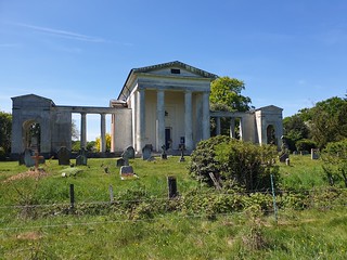
St Mary and Thomas of Canterbury Church, Knebworth Park
May-19 • peter.boon on Flickr
swcwalks book3 walk 340 48322869536


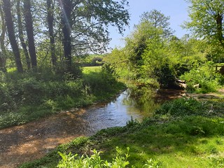
Graffidge Wood. Good for bluebells in Spring
May-19 • peter.boon on Flickr
swcwalks book3 walk340 48322990192
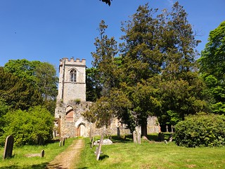
Ruined 12th century church Ayot St Lawrence
May-19 • peter.boon on Flickr
swcwalks book3 walk340 48322869896
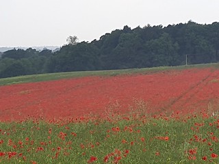
Poppy Field near Sparrowhall Farm. June 2019
Jun-19 • peter.boon on Flickr
swcwalks book3 walk340 48322990052
| Length |
20.8km (13.0 miles). |
|---|---|
| OS Maps |
Explorer 193 for Knebworth and 182 for Welwyn Garden City. Landranger 166 |
| Toughness |
3/10. Ascent 278m; Descent 287m. The walk is stile-free and the paths and trails are easy. |
| Features |
This is a companion walk to SWC 69 the Welwyn Circular, and SWC 353 Knebworth Circular, but covers new territory before lunch to visit the impressive Knebworth Hall and its extensive grounds and deer park. You can also visit the attractive church of St Mary and Thomas of Canterbury. After you leave the motorway behind it is a quiet, pleasant ramble gently undulating woodland and fields. There are no stiles on this walk. The village of Ayot St Lawrence will be familiar from the Welwyn Circular walk and is a perfect spot for a picnic at either the Palladian Church or the ruined old St Lawrence Church. Also here is your lunch-time pub the Brocket Arms. After lunch you reach perhaps familiar territory around Brocket Hall before crossing a golf course en route to Ayot Green and then through woodland to Welwyn |
| Walk options |
On reaching Sparrowhall Bridge mid-afternoon, instead of continuing on the main route to Brocket Park you can take a more direct route to Welwyn Garden City on the Ayot Greenway , the bed of a disused railway. Details of this route are provied in the Main Directions. The Ayot Greenway route reduces the length of the overall walk by some 2 km. |
| Transport |
Trains to Knebworth run from London Kings Cross station. There are two an hour during the week and on Saturday and one an hour on Sunday. Return trains from Welwyn are more frequent and return to London Kings Cross. Buy a day return to Knebworth Suggested Train: Get the nearest train to 10am from London Kings Cross |
| Lunch and Tea |
Your lunch pub is the Brocket Arms (tel 01438 820250) in the village of Ayot St Lawrence, some 11.7 km (7.3 miles) into the walk. This 14th century country inn has many of its original features and is full of character. The pub has spacious internal dining areas plus a small rear garden and a large garden area to its front and side with a covered area. Lunch is served seven days a week between 12 noon and 14.30 hrs. The fare on offer (June 2021) is more basic than in earlier times but is perfectly acceptable if you like good pub grub. The menu might return to its earlier higher standard once Coronavirus is finally over - time will tell. On a Sunday booking ahead is essential and it is advisable to call ahead with numbers during weekdays. Welwyn Garden City has a good choice of cafes, pubs and bistros for your tea stop, most en route and close to the station. Becoming popular with SWC walkers - for its delicious cakes - is Simmons , next door to Cafe Nero, and open until 5 pm. |
| Notes |
Knebworth House and Park The house has been the home of the Lytton Family since 1490. The house was originally built in red brick as a late Gothic Manor house around a central court. The house was remodelled in Tudor Gothic style in the early 19th century and the interior of the house was redesigned by Sir Edwin Lutyens in the early 20th century. The current resident is Mr Henry Lytton-Cobbold and his family. The house and grounds have been a popular setting for films and pop concerts. Since 1974 Led Zeppelin, the Rolling Stones, Pink Floyd and many others have performed in the grounds. Recent films include the Kings Speech (the Balmoral party) and scenes from the Harry Potter series. The house, extensive parkland grounds and tea room are open to the public at weekends and on certain weekdays, from the end of March until the end of September. The park, gardens, adventure playground, dinosaur trail and tea rooms are open from 11 am until 5 pm, and the house and British Raj Exhibition from 12 noon until 5 pm. Prices (2020): adult including the house: £ 14.0. Excluding the house: £ 10.00. Concessions and family tickets are also available. 2021 prices waiting to be announced. The walk route takes you by the beautiful St Mary and Thomas of Canterbury church in Knebworth Park. The church dates from the 12th century and is a Grade 1 listed building. The churchyard has listed tombstones by Edward Lutyens. Ayot St Lawrence This lovely village and its 18th century Grecian style Palladian church and the 12th century Old St Lawrence ruined church will be familiar from the Welwyn Circular walk SWC 69. See this walk for further details. Your lunch pub is here and it makes a perfect spot for your picnic lunch. Brocket Hall Brocket Hall is a Grade 1 classic Country house built in 1760 by architect Sir James Paine. Since its onset the house has been the home of the Brocket family, including former Prime Minister Viscount Melbourne (Lord "M" in the TV series - Victoria). During the 2nd World War the house became a maternity centre - and at least one regular SWC walker was born in the house. More recently, the current 3rd Baron Brocket fell foul of the law over an insurance fraud concerning vintage motor cars and whilst he was a guest of Her Majesty he leased the estate to an Asian company which has converted the estate into a hotel, conference centre and luxury golf centre. The company has added a second golf course - the Palmerson Course - to the Melbourne course. The Ayot Greenway is the railway bed of the former Welwyn to Dunstable sigle track branchline. This branchline opened in 1858 with stops in Ayot, Wheathampstead, Harpenden East, Luton Hoo, Luton Bute Street, Dunstable Town and Dunstabe North. Of the eight railway branchlines in Hertfordshire, the only ones to survive Dr Beeching's cuts in the mid-1960s are the St Albans Abbey line, familiar with SWC walkers from our Garston to St Albans walk, and the Hertford East line. The Welwyn to Dunstable branchline closed in 1966, following which the railway bed was turned into a very pleasant level walkway. Of the other closed branchlines, all bar one have some form of public access. |
| Updated |
First draft and posting of walk May 2019. Features expanded July and August 2019. This update June 2021. |
| Profile | |
|---|---|
| Help Us! |
After the walk, please leave a comment, it really helps. Thanks! You can also upload photos to the SWC Group on Flickr (upload your photos) and videos to Youtube. This walk's tags are: |
| By Train |
Out (not a train station) Back (not a train station) |
| By Car |
Start SG3 6AT Map Directions Return to the start: Finish AL8 6HA Map Directions Travel to the start: |
| Amazon | |
| Help |
National Rail: 03457 48 49 50 • Traveline (bus times): 0871 200 22 33 (12p/min) • TFL (London) : 0343 222 1234 |
| Version | |
| Copyright | © Saturday Walkers Club. All Rights Reserved. No commercial use. No copying. No derivatives. Free with attribution for one time non-commercial use only. www.walkingclub.org.uk/site/license.shtml |


Walk Directions
- Exit Knebworth Railway Station and go straight ahead up Park Lane, immediately passing the Station pub on your left-hand side. You are heading gently uphill, your direction west. The road swings gently to the left and some 650 metres from the railway station you cross the A1(M) on a bridge.
- Keep ahead, still on Park Lane, and still gently uphill, and in 550 metres you come to the village of Old Knebworth at the start of houses on your left and right. In some 300 metres, immediately after the last semi-detached house on your right-hand side (190 Park Lane), with the second of two road narrowing measures ahead of you, there is a green footpath sign at the top of and within the hedge on your right-hand side (in summer it is likely this sign is hidden from view). Here [!] turn right on a grassy, car wide path between hedges, gently downhill, your direction north.
- In 50 metres, with a wooden gate ahead, the path reduces in width and heads down between hedges, with a playing field over to your right. In a further 50 metres go through a wooden kissing gate and keep ahead along the left-hand edge of a field, soon with Cowpasture Wood over to your left. In 115 metres at the end of the field pass through a wooden kissing gate and turn left on to a broad path along the edge of the wood, with an open field to your right, your direction 305°. In 70 metres at a dip in the path, go through a field boundary and keep ahead, uphill. In 110 metres go through a wooden barrier and come out onto Old Knebworth Lane. Cross over and enter Knebworth Park through a deer protection gate, with a cattle grid to its right.
- You now walk through the Park on estate tracks and surfaced roads. In some 200 metres you pass Knebworth House over to your left, then you come to the church of St Mary and Thomas of Canterbury on your right (usually kept locked). Enter the churchyard by the lychgate and follow the path around to the left of the church, to leave the churchyard through a metal swing gate. Now keep ahead over a grassy lawn for some 100 metres to bear right to join the estate road and keep ahead on it, your direction west, soon passing through the main car park, with Knebworth Barns Conference Centre and tea room to your left.
- Keep ahead, soon on a gravel estate road. Some 600 metres from the church's swing gate, by a footpath marker post,[!] turn right off the estate road and head diagonally down over grassy parkland, on a clear way, your direction 280° and head towards the next marker post. At the post follow the grassy way as it swings gently around to the right. Some 580 metres from leaving the gravel estate road, you leave the park through a metal deer protection gate. You now head through overgrowth for some 25 metres to come out on to the B656 road.
- Cross over the road and enter Graffidge Wood by a footpath sign, on to tracks and paths that can be muddy in winter. Follow the track, initially close to the right-hand edge of the wood, as it meanders through the wood. After some 380 metres (in summmer you might have passed a seasonal campsite over to your right) [!] you come to a marker post with yellow and green arrows. Here bear right off the track, keep ahead for 25 metres to cross over another main earth track, and by another marker post with similar coloured arrows [!] take the narrower path directly ahead of you into woodland, your direction 285°.
- Follow the path as it meanders through the wood, latterly through some sharp turns. The woodland clearance and tree felling in 2019 which made it difficult to follow this path has been completed and the route is now clear. In 310 metres you come out on to a tarmac lane. Turn right on to this country lane (Rusling Lane).
- Keep ahead along this quiet lane, and in 200 metres you come to Rusling End Cottage on your left-hand side. Here [!] take the signed footpath to your left . In 15 metres pass through a wooden swing gate to the right of a wooden fieldgate, on a path between hedges, your directionn 230°. You soon have a wood on your left and open fields on your right.
- Follow the edge of wood on your left as your way gradually swings to the left. In 620 metres at the end of the wood turn sharp left to follow the direction of the footpath sign, due south, gently down the right-hand edge of the wood, with open fields to your right. In 220 metres at the end of the wood on your left, keep ahead between open fields, with a tree line to your left, now gently uphill. In 135 metres pass through a hedge to come out onto a road, Three Houses Lane, where you turn right . In 300 metres and just before Three Houses Farm, turn left off the road to follow the footpath sign onto a grassy way, with a woodland strip to your left and a fenceline to your right with horse paddocks beyond.
- In 400 metres pass through a field boundary to come out into a vast open field. Keep ahead, your direction 155° and head towards some trees ahead by a marker post. At the trees go through a field boundary and head downwards towards another marker post, your direction 140°. In another 65 metres go through a gap in the hedge on your right, to head down then up a vast open field (not the path along the field edge to your left), in roughly the previous direction heading towards a field boundary hedge corner on a rise. In 160 metres at the top of the incline keep ahead on a broad, grassy way, initially with a hedge on your left, then between vast open fields.
- In some 600 metres you exit the fields on to a road (the B656 again) where you turn right , on the edge of the village of Codicote . Amost immediately turn right down Whitwell Road. In 420 metres you come to a fork in the road with a grassy triangular area between roads. Here take the left fork (almost directly ahead) and in 80 metres, by a three-way footpath signpost on your right, turn right with the Hertfordshire Way up a bank through trees, ignoring the public footpath along the lane (Kimpton Mill 3/4). At the top of the bank go through a wooden kissing gate, to bear left through a pasture towards a wooden kissing gate, your direction 220°.
- In 75 metres go through a wooden kising gate to bear half right , 240°,over a grassy open field. In a further 180 metres go through another wooden kissing gate to bear half left , your direction 220° towards a wooden kissing gate on the edge of a wood. In 100 metres enter the wood through the kissing gate, to head downhill through the wood, going down a flight of earthen steps. At the bottom of the steps turn right at a T-junction and in 75 metres turn right at a waymarked T-junction, to continue down through the wood. Keep ahead along this woodland path, with treeline on either side. In some 500 metres [!] turn left through a wooden kissing gate, to head down to cross a wooden plank footbridge over a stream with the River Mimram on the left.
- At the far end of the bridge go through another wooden kissing gate and cross over a small, grassy field. In 85 metres go through a wooden kissing gate to cross a wooden footbridge with wooden railings over the River Mimram to reach Kimpton Road, where you turn right . In 30 metres turn left by a public bridleway sign to Abbotshay. Now walk along the right-hand edge of vast open fields with treeline and hedges on your right, initially steadily uphill. Your way levels out and starts to head in and out of a woodland strip on your right. In 900 metres you come out onto a road. Turn right for some 90 metres to come to a junction.
- For the direct route to the lunchtime pub, at this junction turn left and take paths and estate roads for some 600 metres past a Mansion House on your right, heading long its acess drive, until you reach the main road, where you turn right for 40 metres, to come to the Brocket Arms pub on your left-hand side.
- But for a more interesting route to the pub: take the right-hand fork with woodland to your left. At the end of the woodland the path bears left through a wooden kissing gate and you cross a large pasture diagonally towards a church. Leave the field through a wooden kissing gate by the church. The walk route will veer left along a fence on the left before the church, but first explore the churchyard of Ayot St Lawrence Palladian Church (usually open). Then follow the fence on the left through a pasture, ignoring another public footpath diagonally across it. Leave the field through a wooden kissing gate to follow a fenced path to reach a road where you turn left past the ruined parish church. In a further 50 metres you come to the Brocket Arms pub on your right-hand side, your lunchtime stop.
- On leaving the pub turn left into Bride Hall Lane. You pass again the ruined parish church on your right. Continue along the road as it bends to the left. At the road junction with Bibbs Hall Lane (Shaw's Corner) turn right, if you wish to visit George Bernard Shaw's house , after which you return to Shaw's Corner. Continue down the road through two bends and as the road bends again to the right, take the footpath [!] on your left signposted to Codicote Road and Ayot Green Way, a path enclosed by hedges on either side, your direction east.
- In 950 metres you have the start of Stockings Springs Wood on your left-hand side. In bluebell season you may like to enter this wood and walk just inside it, parallel to the main path on your right. You will exit the wood some 25 metres before you reach the road. Otherwise, at the start of the wood, keep ahead on the footpath for another 350 metres, to come out onto Codicote Road. Cross this road and turn left for 5 metres, then take the path cum earth track on your right on a public bridleway, which soon swings to the left. You have a wood on your left and an open field on your right as you head gently uphill.
- In 210 metres go through a field boundary and turn right following a footpath sign, initially down the right-hand edge of an open field with a hedgerow on your right, then gently up the field edge. Near the top of the slope, the broad path swings to the left and away from the wood to your right (Threegroves Wood), now on a car-wide farm track, your bearing 140°.In about 150 metres you have another, smaller wood on your left, and a vast open field to your right.
- Keep ahead and ignore ways off as you leave the wood on your left and proceed between open fields. In 530 metres from the end of the wood on your left you come down to Sparrowhall Bridge , a bridge over the dismantled railway and now the railway trackbed known as The Ayot Greenway . Here you have a choice of continuing with the Main Walk Route to Brocket Park, or joining the Greenway below you for pleasant, more direct route to Welwyn Garden City, which reduces the length of the walk by some 2 km.
- The Ayot Greenway route . At the bridge, do not cross it but instead take the path to the right of its brick headwall and follow a woodland path with uneven footbed downhill, in 40 metres reaching the Greenway below. Turn left on the Greenway, your direction 80° and in 55 metres pass under Sparrowhall Bridge. You will now follow the trackbed of the former single track railway in an easterly direction, very gently uphill, ignoring all ways off to the outskirts of the village of Ayot Green. In more detail: from Sparrowhall Bridge the trackbed is in a tree-lined cutting as it follow a radius curve to the left. In 460 metres cross over Hunters Bridge, with a public footpath below, and keep ahead, now on a high embankment as the trackbed starts a very gradual radius curve to the right. The contours soon level out as the trackbed continues through a shallow cutting, a low embankment and on the level, mostly with treeline either side. In some 1.15 km from Hunters Bridge the trackbed peters out. Either take the slipway on your left down to the road or 25 metres further on drop down a flight of earthen steps with wooden risers and wooden handrail to a road junction. Cross over the junction, ignoring the minor road to your right (Ayot Little Green Road) and keep ahead on St Peters Road, a country road with hedges on either side, gently uphill, your initial bearing 140° in the direction of the village of Ayot Green. In 75 metres you pass on your left an access way to a car parking area for the Greenway. Keep ahead on this country road through its gentle bends and in a further 325 metres you pass properties to your left and right as the road nears the top of a hill, soon with tree-lined green spaces on either side. In 180 metres the road bears to the left at a junction with a minor road on your right. In a further 25 metres you pass Brickwall Close on your right, and in 25 metres you start to cross the A1(M) road on a substantial road bridge. You now rejoin the Main Walk Route in the Directions.
- The Main Walk Route continues from Sparrowhall Bridge as follows: Ignoring a track turning left towards some sheds, keep ahead, slightly right , by a marker post with a yellow arrow, on a narrow path, gently downhill, in 20 metres coming out into the open, with gorse to your left, and vast agricultural fields to your right. Keep ahead on what is now a grassy way which swings to the left and heads downhill. In 310 metres you drop down a flight of earthen steps to a path T-junction, where you turn left to go past a barrier and in 45 metres you reach a road (Waterend Lane), where you turn right .
- In 40 metres, just before a ford in the road,[!] turn left onto a footpath signed to Brocket Hall and Lemsford. Keep ahead on this path, initially with the stream (The River Lea) on your right. Ignore all ways off. In 580 metres you come to a path junction. Here follow the marker post sign ahead into Brocket Park up a steep bank through light woodland with a tree route footbed. At the top of the bank keep ahead through the light woodland and in 185 metres you come out on to a golf course within Brocket Park.
- Follow a clear waymarked path in the open between links and in 420 metes you pass Brocket Hall over to your right (with a golf green in front of it) and red brick golf club buildings. Behind these buildings you have glimpes of Broadwater (lake) within the River Lea. In a further 240 metres the recommended route will have you turning right to cross over the access road - market exit - to soon head up and over the Melbourne golf course.
- If you have difficulty finding the recommended route, or if the two golf courses are particularly busy on tournament days, you might find it easier to follow the surfaced estate exit road in a north north easterly direction for some 700 metres until you come to a lodge building on the edge of the estate, with controlled exit gates. Unfortunately there is no pedestrian exit gate, so you have to scamble through undergrowth to the right of the gates to come out onto a public road, where you turn right and keep ahead. At a road junction bear right and walk through the pretty village of Ayot Green, to cross over the bridge over the A1(M) road - to rejoin the recommended route below.
- The golf course route .
- Your path having descended to join the estate's surfaced access road, marked "exit", you cross over this road with sections of new wooden post and rail fencing on either side, with post tops painted white. Take the signed footpath ahead which soon swings left, gently uphill through a woodland strip. In 80 metres you emerge from the woodland strip, to follow the right-hand edge of golf course open land, with a hedgerow and fenceline to your right. The path is signed the Lea Valley Walk, which you first joined at Waterend before the ford.
- In 170 metres you come to a footpath post with a white painted top. [!] Here you turn sharp left , turning slightly back on yourself, to commence your traverse of the Melbourne golf course. Your initial target is a marker post some 110 metres ahead of you, on a bearing of 35°.
- In 25 metres you cross a surfaced course access path. You then cross a fairway and some 85 metres from the road you come to the marker post. Now keep ahead through trees and in a further 75 metres you come to the next access way, earth and gravel but at times with a wood chip covering. Here keep ahead, your direction now 20° and in 50 metres you cross another fairway by a marker post.
- In 100 metres you come to the next marker post, to then head through trees on an earth track. In a further 100 metres you pass the Tee to hole 13 on your right-hand side, with a putting green over to your left, as your path swings gently downhill to the right, to then cross a narrow tarmac access way, with a putting green below you over to your right. Your path now swings to the left, and some 85 metres from the last tarmac access way, and by a marker post, cross a fairway, slightly to your right, and in 70 metres you come to the next marker post.
- Now follow the path uphill through light woodland as your way swings gently to the right, your initial direction 50°. In 45 metres at the top of the slope, cross another fairway and in 85 metres you come to the next marker post. Now keep ahead on an earth and gravel drive through light woodland. In 180 metres leave the light woodland to cross the head of a tarmac path, with the Tee to hole 4 over to your right.
- Keep ahead, soon to pass a Brickwall Cottage on your right, with a post and rail wooden fence surround. You now exit the course through horse blocking measures, to keep ahead on a gravel path (Brickwall Close) with a fence to your left, which soon bends to the right, with a pond to your right, and in some 80 metres you come out onto Brickhill Close, directly opposite the Waggoners pub and restaurant , an early tea or refreshment option.
- Turn left on this Close, passing the pub on your right-hand side. In 100 metres, as the Close bends to the left, towards the pretty village of Ayot Green keep ahead over some grass, to come out beside the substantial road bridge over the A1(M). Cross over to the far side of this bridge and carefully cross the busy B197 road a little to the left, and by a finger sign post enter Brock's Wood through a metal kissing gate (ignoring another kissing gate about 80 metres away to the right - although this is the main entrance to Sherrardspark Wood). Just past this lower entrance and opposite it is the Red Lion Country pub - another early tea or refreshment option.
- Keep ahead through the wood on a meandering woodland track. In 120 metres you come to a broader woodland track which you join by turning right on to it. You now follow this broad track more or less as straight as an arrow, gently downhill, through Sherrardspark Wood , a nature reserve, your direction 125°.
- In more detail: in 165 metres you pass the start of sleeper retention walls to the right of the track and a little further on the slipway on your right-hand side down to the continuation of the Ayot Greenway . You can if you wish join - or rejoin - the Greenway here, to take a sweeping radius curve gently downhill to the left, but the recommended route is to stay on the woodland track.
- In 140 metres the track goes over a stream and in a further 110 metres it crosses straight over Six Ways Junction, with its central post and six arm signs, with benches and wood carvings to the side of this major path junction. You keep ahead in the direction of Roundwood Drive, now downhill. In 430 metres a path joins from the left and the way swings to the right. In 80 metres you exit the park by a car blocking barrier out on to a residential road (Sherrards Park Road) which you cross. Head down the residential road opposite - Roundwood Drive - and in 50 metres as this road swings left, keep ahead on Reddings (road) for 45 metres, to enter a surfaced footpath between close panel fences.
- In 100 metres you come out onto the Ayot Greenway , where you turn left . Keep ahead along this tree-lined section of this trackbed, ignoring all ways off, and in 455 metres you come to a concrete road bridge. On its right-hand nearside turn right up earthen steps to the road above - Digswell Road. Here turn right and keep ahead, in 60 metres - with the red brick library and theatre complex over to your right - cross over the main, busy road roundabout with care, to enter the formal gardens of Welwyn Garden City , your direction 200°.
- Keep ahead through the formal gardens, passing memorials to Louis de Soissons, who designed and town planned the Garden City, and Sir Theodore Chambers, first chairman of the Garden City Council. You come to a road junction with Cote Brasserie on your left, where you turn left into Howardsgate. On your left you pass a pub, cafes, and restaurants, and you soon come to the recommended tea stop on your left, Simmons which serves delicious cakes.
- Leaving Simmonds, turn left and continue down Howardsgate towards the Howard Shopping Centre . Rather bizarrely, you have to enter this shopping centre in order to reach the railway station. In the main entrance foyer of the Centre, go up the escalator to level 1 where you enter Welwyn Garden City railway station for trains back to London. Fast trains to Kings Cross usually leave from platform 2.