Liphook to Haslemere walk
Lovely walks through wooded Surrey Hills

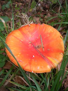
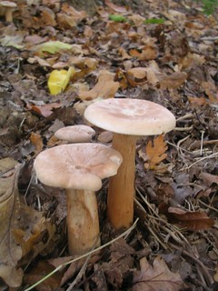
Orange toadstool
Something this big - and orange - should be easily identifiable. But I can't place this one. Liphook to Haslemere
book1 walk6 swcwalks 1960734643

Shulbrede Priory & its woods
| Length | 15km (9.3 miles), 4 hours 30 minutes. For the whole outing, including trains and meals, allow 8 hours. |
|---|---|
| Toughness | 5 out of 10. |
| OS Maps | Explorer OL33 (was 133) or Landranger 186. Liphook, map reference SU 842 309, is in Hampshire, 15km south of Farnham. Haslemere is in Surrey. |
| Features |
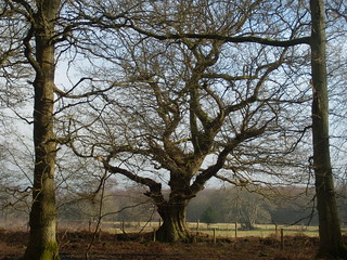
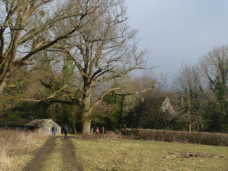
This walk has plenty of relatively mild uphill and downhill sections. It is almost entirely through full-grown mixed woods - mainly oak, beech and chestnut trees - offering plenty of shade on a hot summer's day. After passing Shulbrede Priory in the middle of the woods, you come to the pub and church by the village green in Fernhurst. In the afternoon, you cross streams in the forest before passing through Valewood Park and up into Haslemere, a town surrounded by beautiful countryside. The bridleways immediately after lunch are usually muddy at all times of the year, and very muddy in winter, so decent walking boots are recommended for this walk. |
| Walk Options |
You could shorten the walk by using the hourly Monday to Saturday bus service from Fernhurst, the halfway mark lunchtime village, back to Haslemere; the bus goes from the top of Hogs Hill Road in Fernhurst, along the A286. Walk 22 (Haslemere Circular) uses the same pub in Fernhurst for lunch. For a longer and more energetic walk, you could substitute its afternoon route, climbing Black Down on the way back to Haslemere. |
| History |
Shulbrede Priory is the remains of a priory for Augustinian regular canons dating from about 1200. It was dissolved in 1536, with the King's Commissioner alleging that 26 whores were found at the priory, and it is now a private house. The prior's chamber, above a vaulted undercroft, contains sixteenth-century wall paintings. The priory is open to visitors by appointment (tel 01428 653 049) and also on the Sunday and Monday of the late May and August bank holidays (admission is about £2.50). In Tudor and Stuart times Haslemere was a centre for the iron industry. With the coming of the railway in the mid-nineteenth century it became a popular spot for literary people. The poet Tennyson's house, Aldworth, is on the slopes of Black Down where he loved to walk and George Eliot wrote Middlemarch in Shottermill. Haslemere has an interesting museum up the High Street, 100 metres north of the Georgian Hotel. The museum is open 10am to 5pm Tuesday to Saturday, and has important natural history collections. Other highlights include an Egyptian mummy, Zulu beadwork and Eastern European peasant art. |
| Travel |
Take the train nearest to 9.45am from Waterloo Station to Liphook. Journey time 1 hour 15 minutes. You can sometimes save 15 minutes by taking a faster train and changing at Haslemere. There are four trains an hour back from Haslemere (two on Sundays). Journey time 50-60 minutes. Buy a day return to Liphook. Parking at Haslemere Railway Station costs (2022) £8.50 at weekends, and £ 3.50 on Bank Holiday Mondays (much cheaper spaces available nearby). Parking is easier at Liphook Railway Station (£4 a day), but trains back from Haslemere are only hourly. |
| Lunch |
The suggested lunchtime stop is the Red Lion pub (tel 01428 643 112), some 8.3 km into the walk, by the village green at Fernhurst, offering quality home cooking. As of Spring 2023, it serves lunch, Tuesday to Thursday, from 12 noon until 2pm, on Friday and Saturday from 12 noon until 2.30pm, and on Sunday from 12 noon until 3pm. Closed Mondays. Space inside is limited but the pub has an attractive and good sized back garden with lots of tables under parasols. This popular pub is busy on weekdays and at weekends, and 'phoning ahead from Haslemere railway station with numbers is recommended - and on Sundays it is essential. Even when fully booked the pub can usually accommodate walkers for a drink at it tables in front of the pub. Just down the road from the pub is Fernhurst recreation ground and cricket club, a perfect spot for picnickers. Within Fernhurst Pavilion is The Fern (Cafe) at the Pavilion, (tel 07771 253 768) with opening hours of Wednesday to Friday 8am to 4pm, Saturday 9am to 4.30pm, Sunday 11am to 4.30pm. A good mixed menu with all day brunch, sandwiches and some hot dishes. This is a good alternative to the pub when the latter is fully booked. |
| Updates |
No major changes. Dog problem at [3] is ongoing but now a noisy irritant rather than a problem or danger. Updated: This latest book check and walk update November 2022.Lunch options updated December 2023. |
| Book |
This walk was originally published in Time Out Country Walks near London volume 1. We now recommend using this online version as the book is dated. The book contained 53 walks, 1 for every week of the year and 1 to spare. Here is our suggested schedule |
|---|---|
| Tea |
Haslemere town centre (about 10 mins walks from the station)
Haslemere station
|
| Profile | |
| Help Us! |
After the walk, please leave a comment, it really helps. Thanks! You can also upload photos to the SWC Group on Flickr (upload your photos) and videos to Youtube. This walk's tags are: |
| By Train |
Out (not a train station) Back (not a train station) |
| By Car |
Start GU30 7DR Map Directions Return to the start: Finish GU27 2PD Map Directions Travel to the start: |
| Amazon | |
| Help |
National Rail: 03457 48 49 50 • Traveline (bus times): 0871 200 22 33 (12p/min) • TFL (London) : 0343 222 1234 |
| Version |
Dec-23 Marcus |
| Copyright | © Saturday Walkers Club. All Rights Reserved. No commercial use. No copying. No derivatives. Free with attribution for one time non-commercial use only. www.walkingclub.org.uk/site/license.shtml |


Walk Directions

- [1] Coming off the London train, cross the footbridge. On leaving the Liphook Railway Station building, turn right into the station car park, go under the road bridge and immediately turn left up some steps . At the top, turn left and cross the railway bridge, your direction 140°.
- Follow the road for 650 metres ignoring all ways off, including the access into Churcher's College Junior School, and as the road starts to bend to the right you come to a road on the left signposted Highfield and Brockham Schools. Here turn left into this road, your direction 50°. [2] In 15 metres [!] turn right on to a bridleway into the wood, your direction 105°. Now follow this path, through Stanley Common , ignoring ways off. In addition to the footpath posts mentioned, what were green blobs on trees are now mostly worn away. There is a single post on your right after 40 metres and another on your left in a further 60 metres. In a further 100 metres you have the start of a ditch on your left-hand side. In 200 metres you pass a two-armed sign and keep ahead. In 40 metres the wood opens out a little and the path curves slightly left. Now keeep ahead on a clear path which is to the left and parallel to a former sunken path to its right, your direction 105°.
- In 300 metres you come to a post with a blue arrow pointing left. You now have a choice of routes - a New Route through Access Land (which cuts out some 600 metres of track walking), or the Book's original route.
- The New Route (recommended) At the footpath post with blue arrow keep ahead and in 65 metres you go through a wooden kissing gate into Access Land, with a Lynchmere Society Notice board 3 metres beyond, to keep ahead on a clear path with a post and wire fence on your right, your direction 105°. In 350 metres the path starts to go uphill and diverges from the fence on its right. The wood soon thins out to light brush and heather and in 150 metres you come out onto the track (New Lipchis Way) where you turn right , your direction 140°.
- The Original Route Follow the blue arrow to turn left uphill, your direction 40° In 100 metres, go straight on to join the broad track which has come in from behind you on your left-hand side. The track immediately curves left and crosses a cattle grid. In another 140 metres, at a three-armed footpath sign (with a metal gate away to the left), leave the Sussex Border Path to turn right onto a broad track designated the New Lipchis Way , your direction 130°. Go straight on along this broad track for 900 metres. The New Route joins 600 metres along this track.
- Both routes continue. Keep ahead on the New Lipchis Way and just before you exit the wood a broad track joins from the left and on your right you come to a four-armed footpath sign. You go straight on and in 20 metres cross over a cattle grid, now on a surfaced road, your direction 105°. In 120 metres go through a wooden field gate (or cross the stile to its right) to pass a farmhouse.
- Keep to the right of the farm buildings, and in 30 metres go through another wooden fieldgate (or over another stile) and in 50 metres, as the main track turns left, go straight on following the footpath sign, your direction 100°, downhill, on a car wide earth track.
- In 130 metres, with good views of Marley Common on your left-hand side, follow the track half-right downhill, in a shallow woodland cutting, your direction 140°. Ignore another track forking right uphill.
- In 180 metres, the path curves in a hairpin to the left . Some 65 metres after the bend, as the path levels out, at a two-armed footpath sign [!] turn sharp right , steeply downhill, in a cutting and through a chestnut coppice, your direction initially 70°, then 95°.
- In 150 metres at the T-junction at the bottom, by a three-armed footpath sign, turn left, your direction 40°.
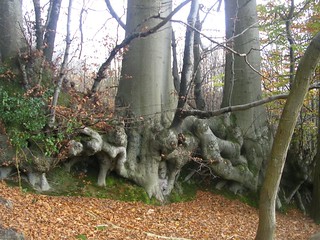
- In 220 metres, by a large beech tree with a dozen trunks, follow the footpath post straight on , a path having joined yours from above on your left.
- In a further 80 metres, by a two-armed footpath sign, leave your main path to follow the sign forking right, your direction 80°.
- [3] In 120 metres you bear left to pass a house and garden, keeping the wooden fence on your right-hand side. Reports of one, sometimes two aggressive dogs here remain . Latest update (August 2020): the dogs are safely behind a wire fence - they are just very noisy - an irritant now rather than a problem. In 25 metres, by a three-armed footpath sign, [!] go through a wooden fieldgate and turn sharp right , with the house fence still on your right-hand side, your direction 150°. In 25 metres, bear right to cross "Baldwin Bridge", go through the (usually propped open) wooden fieldgate at its end and immediately bear left through another fieldgate to go down a wide earthen cum grassy path, your direction 95°. You have a plantation of pine trees over to your right.
- In 100 metres, at the bottom of the slope, the path bends to the right and broadens out, your direction initially 150°.
- Follow the wide grassy path gently downhill through the plantation, ignoring all turn-offs and in 400 metres, just after a track joins from the right, you come to a T-junction at the edge of the plantation, by a two-armed footpath sign. Here turn left , your direction 70°, on a car-wide earth track.
- In 40 metres, at a dip in the track, cross a stream and keep ahead, gently uphill on the other side. In a further 70 metres, ignore a signposted path off to the right and continue towards Shulbrede Priory (as marked on the OS map) just visible through the trees ahead of you.
- In 125 metres, having passed a renovated barn on your left, you come out to a tarmac road. Here turn left , your direction 355°, passing a pond then Shulbrede Priory on your right-hand side. 50 metres beyond the white gates to the building, by a one-armed footpath sign, turn right on a car-wide earth road, with a cottage on your left-hand side, through a woodland strip, your direction 70°.
- In 200 metres, go over a stream and follow the earth road round to the right, your direction now 140°.
- [4] In 150 metres, by the three-armed footpath sign, at a track junction, stay on the main track which turns left , gently uphill, into Greenhill Wood (so marked on the OS map), your direction 45°.
- In 130 metres, as the main track swings to the left, leave it and keep straight on , uphill.
- In 25 metres go through a wooden kissing gate to the left of a metal fieldgate, to keep ahead, steadily uphill, into woodland.
- You are now going to follow an attractive woodland path along the contours of Greenhill Wood, mostly uphill, in a general easterly direction, following footpath signs at intervals. The path undulates, at times narrowing, at other times broadening out to a car-wide track. Keep to the main path, ignoring ways off and keep ahead at cross paths. After 900 metres you come to a cross paths with a signed path going steeply downhill to your right, which you ignore, to keep straight on.
- In a further 450 metres, bear slightly left following the footpath sign, as the main track swings to the right to descend downhill.
- Keep ahead, with the woodland to your right having been cleared. In 180 metres you come to a stile with a metal fieldgate to its left, then to a four-armed footpath sign. 1 metre beyond the stile, [!]. The original Book route had you turning right here, down a steep, narrow path which has become overgrown and almost impassable. Instead, after crossing the stile, keep ahead and in some 35 metres turn right down a broad track.
- [5] In 60 metres, you come out on to a tarmac road by garages to Updown Cottage (the cottage is behind and to the right). Keep ahead down this road, your direction due south and in 400 metres you come to an old house and garden called Thrae (on your left hand side). [!] Your onward route to the lunch pub in Fernhurst is shared with Book 1, Walk 22 - Haslemere Circular walk.
- 80 metres beyond Thrae’s entrance, the lane swings to the right and you take the footpath to the left that is some 20 metres beyond a three-armed footpath sign, to cross over a green open space with oak trees, your initial direction 160° [6].
- In 60 metres, by a footpath post, you enter woods and head down a flight of earthen, shuttered steps to cross a stream on a 3-plank wooden bridge with wooden handrail, then up the other side on more earthen, shuttered steps, steadily uphill, soon with gardens on your right-hand side behind a series of high, close boarded fences. In 225 metres the path becomes tarmac. Keep ahead for a further 310 metes to come out onto the main road, the A286. Cross straight over and head down Hogs Hill Road, keeping to this tarmac road for 400 metres to come, on your left, to the Red Lion pub, which is the suggested lunchtime stop. Just down the road from the pub is Fernhurst Recreation Ground, an ideal spot for picnickers. Within the recreation ground is The Fern (Cafe) in the Pavilion , your alternative lunch stop option.
- After lunch the route is relatively gently uphill for the first 2.5km, on bridleways that can be very muddy all year round. Respite from the mud can be obtained in two ways: when the bridleways are in shallow cuttings you can walk along the top of the banks on either side of the muddy paths: if you are wearing good leather boots, try walking up the streams which run down the middle of the paths after recent rain. Turn left out of the pub and immediately left again to head down the side of the pub and alongside its back garden, following the footpath sign’s direction (80°). In 20 metres pass Manesty Cottage on your right-hand side, and in a further 40 metres you enter the woods.
- Keep to the main path. In 130 metres, you cross a stream and in a further 30 metres you ignore a fork off to the right. In a further 110 metres, you pass two fieldgates off to your left - one metal, one wooden.
- In 70 metres the path swings to the left by a two-armed foootpath sign. In a further 130 metres the path bends to the right to cross a stream where the water falls down from a storm pipe, with the stream soon on your left-hand side [7].
- In 170 metres, at the next T-junction, with a wooden barn opposite, turn left following the footpath sign, on a car-wide earth track, uphill, your direction 30°.
- In 80 metres, at a crossing of paths, with a three-armed footpath sign on your right, take the wide left fork uphill, your direction due north, a potentially muddy path.
- Follow the track as it winds uphill, ignoring turn-offs. 380 metres further uphill, after a crossing of paths, follow the public footpath as it bends to the right, still uphill, your direction 60°.
- In 150 metres, at a path junction, fork left following the footpath sign, your direction 345°.
- In 340 metres, at the top of the incline, with a ditch stream on your right-hand side, ignore a fork down to the left, to keep straight on.
- In 150 metres, you come to a bridleway T-junction by a three-armed footpath sign on your right. Take the level way to the left, virtually straight on, your direction 315°, ignoring the bridleway uphill and behind to your right. In 20 metres you pass a broad grassy avenue going uphill on your right. Ignore all ways off and in 120 metres, at a major crosspaths, take the fork, not straight on, but slightly to the right , a signposted bridleway, your direction 350°.(the grassy avenue uphill to your right is private).
- Keep to this path with a mesh fence on your right and in 130 metres go over a grassy path crossing , by a three-armed footpath sign, and in a further 120 metres you come to a wooden panel fence on your left-hand side.
- Keep ahead for 200 metres, initially on a grassy, car-wide way, which turns to earth as it ascends and swings sharply to the right. In 100 metres, by a two-armed footpath sign, fork left , your direction 15°, to drop down to a tarmac road 20 metres below.
- [8] Cross straight over the tarmac road to take the signposted footpath downwards (a restricted byway), your direction 315°.
- [!] In 120 metres, by a post on your left-hand side (easy to miss in summer) with a yellow and green arrow, follow the yellow arrow turn sharply to the right and climb the bank on a faint footpath, steeply uphill, your direction due east, initially going back on yourself with the path below.
- Stay on this narrow, woodland path which bends to the left , still steeply uphill, until you come out into a field, where you turn right along the edge of the field, with a post and mesh fence on your left, your direction 345°. Keep ahead on this grassy way, in open countryside, between horse paddocks, which can be muddy in winter.
- In some 300 metres, at the far right corner of the field and at the end of the path, turn right for 10 metres to go through a metal gate in a wooden kissing frame, to head along a narrow, enclosed footpath, your direction 90°.
- [9] In 100 metres, come out through a broad opening on to a tarmac road by Wadesmarsh Farmhouse.
- Cross over the road, slightly to the left, to continue on a signposted bridleway, your direction 10°. In 30 metres, you pass through a wooden swing gate to the left of a wooden fieldgate to enter the National Trust’s Valewood Park. There are good views of Black Down on your right-hand side.
- Keep straight on for 500 metres on a grassy way in open countryside, until you come to a large and isolated oak tree with a three-armed footpath sign next to it, at which point [!] you leave the main track to fork left, your direction 330° [10].
- In 100 metres go through a wooden swing gate into a wood. Keep to the main way straight on. In 300 metres, ignore a fork to the right and in a further 35 metres ignore one sharply to the left. In another 125 metres, and 5 metres before you have a wooden kissing gate and a wooden fieldgate ahead of you, by a three-armed footpath sign, turn right downwards on the Serpent Trail, your direction 50°. Go down earthen steps and on a series of planks over a potentially muddy zone, to veer left with the path at the bottom of the hill and continue with a stream on your right-hand side.
- In 75 metres, go on two planks over the stream and in 25 metres, you come out on to a road near the entrance to Valewood Farm House [11]. Turn left on the road and then immediately sharp right to go past Stedlands Farm on your left, your direction 40°.
- Go past the entrance drive on your right that leads to ‘The Stables’, a large new brick house with diamond-paned windows. In 10 metres, at a fork in the track marked with a footpath sign, take the left-most bridleway uphill, your direction 20°. Then go fairly steeply uphill, ignoring turn-offs, in a cutting through a woodland strip. In 500 metres, you come to a tarmac road at the top with a house called Littlecote on your left-hand side, and with a recently rebuilt red brick house on your right. Turn left along the road and in 20 metres turn right up a tarmac path marked ‘Neighbourhood Watch Area’, with an anti-motorbike barrier at its start, the direction 20°, and soon with playing fields on your left-hand side.
- In 350 metres, cross a minor tarmac road and keep straight on down a path with steps between high hedges, to the main road, the B2131. [12]. Turn left and then in 150 metres turn right into Haslemere High Street . In 40 metres, you pass the Swan Inn on your left and the White Horse Hotel on your right-hand side. 100 metres beyond this, you come to the suggested tea places, the recently refurbished Darnleys across the road to your left, and Hemingways on your right. Both serve excellent teas and cakes. Nearby, on West Street, on your way to the railway station, you come to the Real English Drinks House .
- Coming out of Darnleys, turn right and in 25 metres turn right again down West Street, signposted to the police station. In 120 metres, where the main street curves to the right past the police station (which is on your right-hand side), take the street straight on to the fire station, but then not the tempting path straight on; instead, turn left in front of the fire station along a tarmac lane and in about 50 metres turn right along a narrow tarmac path to continue to the left of the fire station, your direction 315°.
- Now follow this path, with a stream to your right and later a playground to your left, till you come out on to a tarmac road with Redwood Manor opposite. Turn left and in 40 metres, turn right on to the B2131, leading in 260 metres to Haslemere Railway Station on your right-hand side. The London platforms (2 and 3) are over the footbridge.