Biggleswade to Sandy walk
The Greensand Ridge Walk along grassy tracks and woodland trails, with two picturesque villages


| Length |
Main Walk: 18¾ km (11.7 miles). Four hours 10 minutes walking time. For the whole excursion including trains, sights and meals, allow at least hours. Short Walk, omitting Old Warden: 11¾ km (7.3 miles). Two hours 30 minutes walking time. Circular Walk, omitting Old Warden: 19½ km (12.1 miles). Four hours 15 minutes walking time. Long Circular Walk, via Old Warden: 26½ km (16.5 miles). Six hours walking time. |
|---|---|
| OS Map |
Explorer 208. Biggleswade, map reference TL193441, is in Bedfordshire, 7 km ESE of Bedford. |
| Toughness |
2 out of 10 (1 for the Short Walk, 4 for the Long Circular Walk). |
| Features |
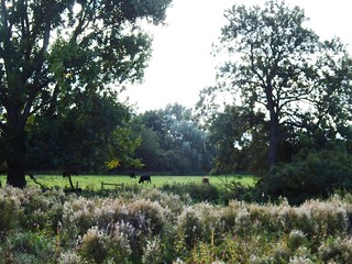
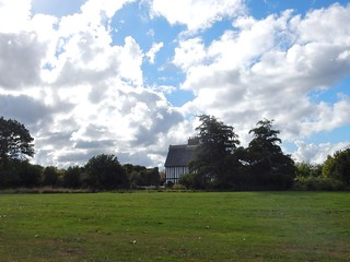
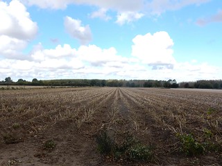
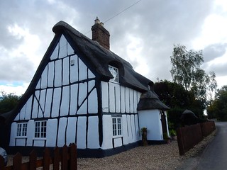
This Bedfordshire walk takes in a rural area to the west of a corridor containing the former Great North Road, the East Coast Main Line and the River Ivel, a tributary of the Great Ouse. Once past the A1 this is a predominantly flat area of arable farmland and patches of woodland, with some attractive villages of thatched cottages and ironstone churches. On the outward route from the market town of Biggleswade you are likely to see some light aircraft flying about as you head towards Old Warden Aerodrome, home to the famous Shuttleworth Collection of historic working aircraft and other vehicles. After skirting the airfield the walk continues through the wooded Warden Warren (where a short detour would reveal two secluded Landmark Trust properties) to the suggested lunch pub in the picturesque village of Old Warden. After passing its richly-decorated church a gentle climb leads onto a low ridge where you join the Greensand Ridge Walk. The rest of the walk follows this waymarked trail back towards the River Ivel and the town of Sandy, along the way passing through another attractive village, Northill. |
| Path Closures |
As a consequence of the Shoreham air crash in 2015 the lanes, bridleways and footpaths around Old Warden Aerodrome are closed when an airshow is taking place, typically twice a month in summer. No alternative routes have been researched, so it would be advisable to check this Shuttleworth Airshows page and avoid the walk on any of those dates. |
| Walk Options |
Two contrasting options have been provided for this walk, one which shortens it by 7 km and an extension which lengthens it by 7¾ km. The Short Walk option cuts out the westernmost part of the walk by taking a direct route via Ickwell to Northill. The motivation behind this somewhat inferior option (omitting the many interesting features in and around Old Warden) was to encourage walkers to combine it with the second option, an extension from Sandy back to Biggleswade on the other side of the railway to make a Circular Walk. This extension climbs a low wooded hill which was once an Iron Age hill fort and is now the site of The Lodge, the UK headquarters of the Royal Society for the Protection of Birds (RSPB) and a nature reserve (free entry, but note that it closes at dusk). A fairly direct main route is suggested with just two short optional detours, but a longer route taking in more of the RSPB's waymarked nature trails is described in this walk's companion, the Sandy to Arlesey walk (#412). The route continues across Biggleswade Common and returns to the town via an attractive riverside stretch. Combining this extension with the full Main Walk is also possible and would make a Long Circular Walk. |
| Additional Notes |
This walk's original author created it in the opposite direction: a Main Walk from Sandy to Biggleswade, with the (rarely taken) option of completing a Long Circular Walk via Biggleswade Common and the RSPB reserve. In this orientation the two lunch pubs were not ideally placed, with the one in Northill coming too soon and the other rather too late. The new author feels that it works better this way round, with the Old Warden pub well placed on the Main Walk and the Northill pub on the Short and Circular Walks. The main drawback is the paucity of tea options when finishing in Sandy. The old walk document is still available to download from the “Sandy to Biggleswade original option” button above, although following those written directions would take you on a slightly different route in a few places where the layout on the ground has changed. In practice you could use the revised GPS route in either direction. |
| Transport |
Biggleswade and Sandy are adjacent stations on the East Coast Main Line. On weekdays there is a half-hourly cross-London Thameslink service via East Croydon, London Bridge and St Pancras; on Sundays there is an hourly service from Kings Cross. The journey time to Biggleswade is about 45 minutes from central London. Unless you will definitely be completing a Circular Walk back to Biggleswade, buy a return to Sandy. If you wanted to abandon the walk at Old Warden you would need to call a taxi, but there is a bus service (Mon–Sat) through Northill and Ickwell to Biggleswade. If driving, the station car parks both cost around £4 after 10am weekdays, £3 weekends (2024). If you want to return to your car from Sandy there is a bus service (Mon–Sat) which you could use if the trains were disrupted. |
| Suggested Train |
Take the train nearest to 10:15 from St Pancras or Kings Cross to Biggleswade. |
| Train Times |
|
| Timetables |
|
| River Levels |
|
| Lunch |
The suggested lunch place on the Main Walk (after 7¼ km) is the Hare & Hounds (01767-627225) in Old Warden, which has a large sloping garden at the rear. On the Short Walk the suggested place (after 6¾ km) is The Crown at Northill (01767-627337; closed Mon), which also has a large beer garden. This pub would also serve as a mid-afternoon refreshment break (or a very late lunch stop) at weekends on the Main Walk, but is closed from 3-5.30pm on weekdays. Both of these pubs are relatively up-market and you would need to book at weekends to be sure of a table. |
| Tea |
The most convenient tea place in Sandy is The Bell (01767-448401), a traditional pub across the road from the station. Some alternative pubs and Mama's Coffee Shop are about 500m away along the High Street, but the café is likely to be closed by the time you finish the walk. There is more choice if you complete a Circular Walk. The route through The Lodge passes close to a new RSPB café (01767-693333; open to around 4pm) in the gatehouse. In Biggleswade two possible places on opposite sides of the central Market Square are Surfin Cafe (01767-220581; open to 6pm Mon–Fri, 5.30pm Sat, 5pm Sun & BH); and Rosso Lounge (01767-600575), a café / bar open all evening. There are also several pubs in the vicinity, including the White Hart (01767-314219) and a JD Wetherspoon's on the High Street, the Crown Hotel (01767-310510). Allow at least five minutes to reach the station from Market Square. |
| Profile | |
|---|---|
| Help Us! |
After the walk, please leave a comment, it really helps. Thanks! You can also upload photos to the SWC Group on Flickr (upload your photos) and videos to Youtube. This walk's tags are: |
| By Train |
Out (not a train station) Back (not a train station) |
| By Car |
Start SG18 8AL Map Directions Return to the start: Finish SG19 1AW Map Directions Travel to the start: |
| Amazon | |
| Help |
National Rail: 03457 48 49 50 • Traveline (bus times): 0871 200 22 33 (12p/min) • TFL (London) : 0343 222 1234 |
| Version | |
| Copyright | © Saturday Walkers Club. All Rights Reserved. No commercial use. No copying. No derivatives. Free with attribution for one time non-commercial use only. www.walkingclub.org.uk/site/license.shtml |

Walk Directions
Click the heading below to show/hide the walk route for the selected option(s).


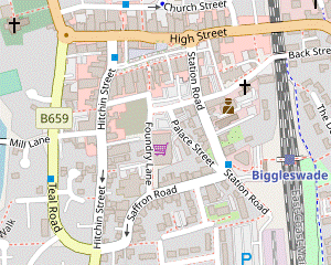
 Walk Map
©
Walk Options
Click on any option to show only the sections making up that route, or the heading above to show all sections.
- Main Walk (18¾ km)
Walk Directions
Click on any section heading to switch between detailed directions and an outline, or the heading above to switch all sections.
- Biggleswade Station to Bricklamp Covert (4 km)
- From the station head west on Saffron Road and go straight ahead at traffic lights onto Teal Road. Turn left into Mill Lane, cross the River Ivel and keep ahead on a bridleway. Switch to a footpath on the left to get under the A1 via a tunnel, then briefly rejoin the bridleway before another small detour on the left, along the northern edge of Broom East Wildlife Conservation Site. Cross Gypsy Lane and follow the bridleway along field edges and past Broom's ‘Big Lake’ to the B658. Keep ahead along a private road (the continuation of the bridleway) past Kingshill Farm to reach a bridleway junction by Bricklamp Covert.
- From the island platform go up steps to the footbridge and turn left. Outside the station bear slightly left and go down to a road junction. Cross over Station Road to continue along the right-hand pavement of Saffron Road, which curves left and right and comes to a crossroads.
- Go straight ahead, now on the B659 (Teal Road), which curves round to the right. In 200m cross the road at the pedestrian lights and turn left into Mill Lane. This goes past the converted Ivel Mill? and crosses the River Ivel. Ignore paths off to both sides to continue on a public bridleway between farm fields, heading W.
- About 100m before reaching the A1 veer left onto a narrow path between high hedges, the continuation of the bridleway. The path gradually approaches the main road and continues alongside it for 150m before swinging right, allowing you to pass under it through one of several flood tunnels.
-
On the other side turn half-right onto a stony path. In 100m it crosses a ditch and turns left onto a grassy track, briefly rejoining the original bridleway. In just 30m the suggested route is to turn left onto a signposted permissive footpath into the north-eastern corner of the Broom East Wildlife Conservation Site?.
- You could simply stay on the bridleway up to Gypsy Lane (350m ahead), but this little excursion is only 50m longer.
- Inside the conservation area fork right onto the main perimeter path, passing a pond on the left and coming to an information panel about the restoration project. Carry on through the grassland for 250m, never far from the bridleway, to reach a second information panel about the area's biodiversity. Veer right here onto a side path which takes you out of the conservation area to where the bridleway meets Gypsy Lane.
- Cross the road carefully (traffic can be quite fast) onto the continuation of the bridleway, which turns half-right and goes across the middle of a large farm field. On the far side cross a ditch on a plank bridge and continue along the right-hand edge of another farm field. In 200m follow the grassy path as it curves left, away from the tree boundary.
- In the next 700m the path meanders through the grassland, soon with glimpses of a large fishing lake behind a wire fence on the left. It then crosses an access track to the lake, passes a reed-lined pond on the right and comes to the B658. Cross the road carefully (again, traffic can be quite fast) and take the private road opposite, signposted as a public bridleway.
- Go along this tree-lined lane for 800m. Halfway along you pass some agricultural college buildings on the right at Kingshill Farm, then a large detached house (sometimes with a helicopter on the lawn). You then pass a couple of places where the lane widens, with a wood (Bricklamp Covert) on the left. Near the end of the second passing place there is a gate in the hedge on the right.
- Bricklamp Covert to Old Warden (3¼ km)
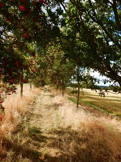
- Continue along the lane, joining the North Bedfordshire Heritage Trail (NBHT). In 100m veer left in front of an entrance to Old Warden Aerodrome to head south-west on the bridleway for nearly 1½ km (with a small kink through a copse along the way). At the end turn right onto a minor road, then in 550m turn right into Warden Warren. Follow the NBHT through this woodland, with a possible detour in the middle to go past one or two Landmark Trust properties off to the right. At the far end turn left onto a street (The Village) to come to the Hare and Hounds pub in Old Warden.
-
For the Main Walk ignore the gate and carry on along the lane for 100m, joining the North Bedfordshire Heritage Trail? (NBHT). Where the lane bends right you should veer left through a wide gap in the hedge with a waymarker post, to continue on a fenced grassy strip which runs parallel to the lane for 40m before turning left.
- This short stretch can be waterlogged. It appears that most walkers bypass it by continuing briefly along the lane, then nipping through a small gap in the hedge just before the entrance to Old Warden Aerodrome.
- The fenced bridleway now heads SW alongside a large field, with glimpses of the airfield through the trees on the right. In 400m a waymarker post directs you to fork right for a short interlude through a piece of woodland. The path goes alongside a stream and passes a bench with a couple of droll plaques, then zig-zags sharply left and right to rejoin the grassy path outside the wood.
- After this mysterious little kink the bridleway heads SW again for 800m, initially alongside Lowsiebush Covert and crossing a private road halfway along. At the far end go out through a gate and turn right onto a minor road, soon with a lake visible through the trees on your left. You have just over 500m of road walking, but there is a grass verge and not much traffic.
- After the road bends slightly left you pass an isolated house on the right. At the end of its garden veer right through a fieldgate onto a broad track through Warden Warren, still on the NBHT and heading NW. In 200m you reach the first of three tracks forking off to the right, with an information panel about one of the two Landmark Trust properties in this estate woodland.
-
Detour via Cottage and Summerhouse (+400m)
- Fork right onto the first track, which in 225m passes Keeper's Cottage? down to the right (though partly hidden by trees). The track then swings round to the left and in a further 200m you reach a small clearing containing an 18thC folly, Queen Anne's Summerhouse?.
- The shortest way to resume the main route is to take the right-hand track away from the folly, although the information panel about it is inconveniently situated at the far end of the left-hand track.
-
Detour via the Summerhouse only (+350m)
- Carry on along the main track for 125m and fork right onto the second track, going through a wooden fieldgate with another information panel. In 225m … Return to the main route via the other track.
- From either of the detours turn right to resume your route along the public footpath. The woodland track bends slightly right and later starts to descend, eventually emerging onto a street (The Village). Turn left to go through Old Warden for 150m, passing several attractive thatched properties. Shortly after passing the Village Hall you reach the suggested lunch pub on the left, the Hare and Hounds.
- Old Warden to the ‘tree tunnel’ (3 km)
- Continue briefly along the lane, then turn right by the Guest House onto a footpath leading to the Abbey Church of St Leonard. Turn left and take the footpath from the back of its car park, which curves right to head north-west. Follow the NBHT for nearly 2 km in this direction, through Palmers Wood and then along field edges to a footpath junction. Turn right, staying on the NBHT and also joining the Greensand Ridge Walk (GRW). In 450m follow the path round to the right to come to a path T-junction in a tree tunnel.
- Turn left out of the pub to continue briefly along the road, then turn right onto a footpath opposite the Old Warden Guest House, still on the NBHT. In 175m the path goes up a short slope and swings right. Keep ahead through an old kissing gate onto a fenced path, soon with a view through the trees on the right of Shuttleworth House? and a lake in its grounds.
- At the end go through another gate onto a lane, with the Abbey Church of St Leonard? opposite. The route continues to the left through the church car park, but the church itself has several unusual features and is well worth a visit.
- Make you way to the back of the car park and go through a gate with a footpath waymarker. The path curves round to the right and passes an information panel about a nearby Field Maple tree. Keep right at a path junction to continue along the right-hand edge of a field, soon with two thinly-disguised telecommunications masts off to your right.
- Keep ahead across an open area and then on a broad grassy strip through Palmer's Wood for over 500m, heading NW. On leaving the wood follow the path as it swings right and left to continue for 600m along the edge of two large fields, with a hedge on your right. At a kink in the second field keep ahead through a gap in the tree boundary and veer left and right to go along the edge of a third field, now with a hedge on your left.
- In 200m turn right at a crosspaths in the field corner, staying on the NBHT and also joining the Greensand Ridge Walk? (GRW). Go along this grassy path between fields for 450m, soon with a distant view on the left of the two huge Airship Hangars? at Cardington, 4 km away. At the end of the field follow the path round to the right to come to a path T-junction in a tree tunnel.
- The ‘tree tunnel’ to Northill (3½ km)
- Turn left go through this tree tunnel. In 800m turn right onto a footpath, staying on the GRW but leaving the NBHT. Follow the GRW around the buildings of Highlands Farm, then on a zig-zag course through Home Wood. Continue past fish ponds and paddocks and turn right to enter Northill on Bedford Road. Cut through the churchyard of St Mary the Virgin to visit The Crown pub.
- Turn left onto a broad track through this tree tunnel, staying on both the NBHT and GRW. In 400m ignore a footpath off to the right along a field edge, but in a further 400m turn right through a wide gap onto another footpath heading ESE, staying on the GRW but finally leaving the NBHT.
- The path passes an isolated tree as it climbs gently between two fields, goes past the left-hand end of a hedge and starts to descend. At the bottom of the slope veer left and right to go through a strip of woodland and continue on a grassy path across a field, heading E.
- On the far side go through a gate onto a fenced path which skirts around the buildings of Highlands Farm, with several more gates along the way. Eventually the path turns sharply right to go through another gate into a wood. The path soon emerges from the trees to continue along the right-hand edge of a field. Follow it round to the left in the corner, then in 100m turn right into the main part of Home Wood.
- In 200m turn left as indicated at a path T-junction. In a further 150m turn right at another path junction to stay on the right of way (the waymarker here was missing when last checked). In 150m the path crosses a ditch on a footbridge and bears left. In a further 150m keep ahead at a crosspaths to come to the edge of the wood. Go out through a gate and bear right onto a grassy track heading E, passing a fish pond on your right.
- In 150m keep ahead at a path crossing and continue in the same direction for a further 200m, with a hedge on your left and paddocks on the right. At the end go through a wooden barrier and out between houses to a road (Bedford Road). Turn right and follow the road round a left-hand bend into Northill.
- At the end of this road you will be turning left to leave the village on Thorncote Road, but the suggested route is to go over a low stile on the right (or through a metal gate just beyond it) into the churchyard of St Mary the Virgin?. Follow the path round the tower to its entrance (and perhaps a quick visit), then out through a gate on the far side for a possible mid-afternoon refreshment stop at The Crown.
- Bricklamp Covert to Northill direct (2¾ km)
- Turn right off the lane, joining the North Bedfordshire Heritage Trail (NBHT). Follow the bridleway across a field, past some fish ponds and a gate leading into Old Warden Aerodrome, then alongside a stream to a minor road. Cross the road onto the continuation of the bridleway and follow it into the village of Ickwell. Go along the right-hand side of its large green and leave the village on Northill Road. Go along it for 800m (becoming Ickwell Road where it crosses a stream) into the village of Northill, where The Crown is set back from the road by the church of St Mary the Virgin.
- For the Short Walk go through the gate onto a grassy path across a field, joining the North Bedfordshire Heritage Trail? (NBHT) and heading N. In 150m go through another gate and continue past some fish ponds on your left, then a stream. At a wide gap in the hedge on the left there is a view along one of the grass runways of Old Warden Aerodrome.
- The path veers left and right, following the course of the stream. After crossing a ditch on a footbridge it turns sharply left, goes round two sides of a field and comes out onto a lane. Cross over and take the continuation of the bridleway, just off to the left on the other side of the stream.
- The bridleway goes alongside a line of trees on the right-hand edge of a large field. In 300m it turns half-left and continues between the fences of properties in the village of Ickwell, coming out on the corner of its large village green. Keep ahead along its right-hand side.
- On the far side cross a lane and continue on a tarmac path along the edge of a smaller green. The path gradually approaches a road on the left (Northill Road) and becomes its pavement. You now simply follow this road for 800m, crossing over to the left-hand side at a bridge over a stream halfway along, where it becomes Ickwell Road.
- Eventually you enter the centre of Northill and pass an information panel about its Village Pond on the left. For refreshments The Crown is set back from the main road on a short lane running alongside the churchyard of St Mary the Virgin?.
- Northill to the Great North Road (3½ km)
- From the village follow the Greensand Ridge Walk (GRW) and NBHT: initially northwards on Thorncote Road, then turning right to follow a succession of footpaths via the Caldecote House Farm conservation area and Beeston Fields to Beeston Village Green. Go along The Crescent to the A1.
- From the pub or churchyard make your way out to the main road and turn left, heading N. After the junction with Bedford Road this becomes Thorncote Road, with some attractive thatched cottages; you are now on both the Greensand Ridge Walk? (GRW) and the North Bedfordshire Heritage Trail? (NBHT).
-
In 300m the NBHT takes a signposted footpath through a narrow gap in the hedge on the right, but the suggested route is to stay on the GRW: carry on along the road for 150m and then turn right by the entrance to Llahsram House, going past a metal fieldgate onto a broad track heading E. In 350m the NBHT rejoins from a gap in the hedge on the right.
- The straight-line route taken by the NBHT is 125m shorter, but the second field it goes through is rather uneven and the entrance to it can be very muddy.
- The track goes past an information panel for the Caldecote House Farm conservation area. You now follow it for 1 km to a road (Vinegar Hill), crossing a stream on a footbridge after 400m and later zig-zagging left and right as directed at a couple of T-junctions. Cross the road onto the continuation of the footpath, a narrow grassy path through a long belt of trees.
- At the far end there is an information panel for Beeston Fields. Turn left onto a path between fields, then in 100m turn right to go along the left-hand edge of a field for 400m, crossing a ditch on a footbridge along the way. At the far end do another left-and-right zig-zag onto a path heading directly towards what looks like a large house 300m away, but turns out to be a main house with several outbuildings.
- Follow the path past the left-hand side of the property (Elm Farm) and out onto Beeston Village Green, an open space ringed by many different tree species. Your onward route is off to the left, but the suggested route is to go straight ahead to the far side of the green, where there is an information panel listing all these trees.
- On the far side turn left and go along the edge of the green for 100m, then turn right into The Crescent. At the end of this cul-de-sac keep ahead on a fenced alleyway to reach the A1 (the old Great North Road).
- The Great North Road to Sandy (1½ km)
-
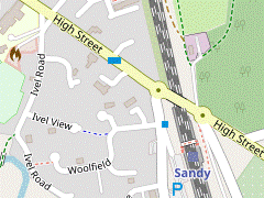 Cross the A1 on a footbridge and continue on a footpath which goes past the southern end of The Riddy nature reserve to the River Ivel. Turn right onto the riverside path and enter Sandy on Ivel Road, then cut through Ivel View and Woolfield to The Bell pub on Station Road.
-
If finishing the walk here, the station is off to the right across Station Road.
-
If finishing the walk here, the station is off to the right across Station Road.
-
Cross the dual carriageway on the high footbridge, taking the steps down to the right on the other side. At the bottom of these steps take the signposted public footpath heading away from the road.
This appears to be a newly-designated right of way as it still has some “permissive path” waymarkers. It avoids a short but unpleasant stretch alongside the very noisy A1.
- In 200m follow the fenced path round to the left to come to a T-junction with the original footpath (The Baulk). Turn right onto this broad tree-lined path, which soon crosses a footbridge over a stream and passes a Wildlife Trust information panel for The Riddy?, the water meadows stretching away to the left.
-
Follow the path across a substantial bridge over the River Ivel (with the remnants of a mill pool on the left) and veer right onto a tarmac path going past a weir on the old millstream. After passing a row of riverside properties there is a metal kissing gate at the start of a patch of woodland on the left.
- If it does not look too overgrown you could detour onto this riverside path, which rejoins the main path through another kissing gate 300m ahead.
-
After the second kissing gate the main path swings left and crosses the river. Bear left briefly onto a residential street (Ivel Road), then turn right into Ivel View (with a Greensand Cycleway sign, but leaving both the GRW and NBHT).
- This direct route goes past a pub on the way to the station. If you wanted to investigate alternative refreshment places you would have to continue to the end of Ivel Road and turn left onto the High Street (away from the station). If you do this, return along the High Street and continue to its junction with Station Road.
- On the direct route, keep ahead at the end of Ivel View onto a short link path between houses. Bear left onto another street (Woolfield) and go out to its T-junction with Station Road, with The Bell on the corner.
-
Finishing at Sandy Station
-
From the pub, the straightforward route is to cross Station Road and go down the short access road on the right to the far end of the station buildings. The entrance leads onto the northbound platform, so for trains to London you have to double back along the platform – passing an information panel about Captain Sir William Peel? – and cross the station footbridge to Platform 1.
-
The signposted pedestrian route for trains to London is to cross the tracks on the road bridge (the continuation of the High Street), then turn right onto a path leading down to Platform 1. This is a slightly longer route from the pub, but shorter if coming from the High Street.
-
The signposted pedestrian route for trains to London is to cross the tracks on the road bridge (the continuation of the High Street), then turn right onto a path leading down to Platform 1. This is a slightly longer route from the pub, but shorter if coming from the High Street.
- Sandy to Biggleswade Common (3 km)
-
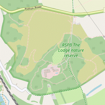 Cross the railway on the High Street and continue along the B1042 (Potton Road). In 600m turn right through a pedestrian entrance into The Lodge nature reserve. The suggested (direct route) is to turn left at the first path junction to go back towards and then parallel to the road. At the vehicle entrance turn right onto a bridleway running through the nature reserve and follow this southwards for 1 km to the exit on its southern boundary. Keep ahead on the bridleway to enter Biggleswade Common.
-
The RSPB leaflet for The Lodge includes a map with three designated trails around the reserve which you could use if you wanted to explore it more fully.
-
The RSPB leaflet for The Lodge includes a map with three designated trails around the reserve which you could use if you wanted to explore it more fully.
- Make your way to the junction of Station Road and the High Street and cross the railway on the road bridge (the B1042, which becomes Potton Road). Ignore minor roads off to both sides and walk along the wide pavement of the main road for 600m, passing the town's cemetery.
-
Just before reaching some chevrons at a left-hand bend, turn right through a pedestrian entrance into The Lodge Nature Reserve. Follow the track round to the left, climbing steadily through pine woods. In 300m you come to a path junction.
- For a straightforward route fork left at the junction, signposted to the Shop. In 200m the track curves right and traffic noise through the trees on the left will reveal that you are walking parallel to Potton Road. In 500m the path approaches Swiss Cottage, built for Captain Sir William Peel?.
- Unless you want to visit the RSPB café in this gatehouse, veer right about 50m before reaching it onto a path signposted to the Visitor centre, which turns out to be a low open-sided building with information panels about the reserve. Carry on along the main path heading S, parallel to the driveway on your left (which is also a public bridleway).
- In 100m keep ahead at a path crossing, ignoring the first signpost for the Woodpecker trail. In a further 300m there is another path junction, with a choice of routes. The main route simply follows the public bridleway out of the reserve, but you could detour via the gardens in [?] or around the heathland in [?].
-
Main route
- Turn left at the junction, signposted to (a shorter version of) the Woodpecker trail. On reaching the driveway turn right, then immediately fork left onto the signposted bridleway.
- The bridleway drops gently downhill through woodland for 400m. Ignore paths off to the right for the Nuthatch trail and follow it out of the reserve, passing between stone pillars.
-
Gardens Extension (+300m min)
- Keep ahead at the junction, signposted to the Nuthatch trail and Gardens. In 50m you pass a small area on the right, with a viewpoint across a small pond to a meadow. In a further 50m turn left at a path junction, signposted to the Gardens.
- Go straight across the driveway and follow the path as it curves round to the right. A side path on the right leads to a large owl sculpture with memorial plaques, the Tree of Life.
- Returning to the main path, it soon merges with another one coming from the driveway. The entrance to the Gardens is to the left of the main building, which you might be able to glimpse through the trees ahead.
- Just before a gate with a “Welcome to the Lodge Gardens” panel, there is a path off to the left signposted to the Nuthatch trail which is your way back to the main route.
- Enter the gardens, with a view of The Lodge? across the fountain pond. Explore them as you wish before returning to this point. You could simply walk around the pond, or wander a bit further ahead through the trees and shrubs.
- Leave the gardens and turn right at the path junction you passed earlier. Go through a gate and down steps through the woodland. At the bottom turn left at a T-junction, briefly joining the Nuthatch trail.
- Where the path splits fork right, then turn right onto the bridleway at a T-junction. In 150m …
-
Heathland Extension (+350m)
- … go straight across onto the path opposite. This turns left, descends a flight of steps and swings right, soon passing the small Jack's Pond on the right.
- In 200m keep right at a path junction, signposted to Old Heath and joining the full Woodpecker trail. Follow the path for 450m as it curves gradually round to the right through the heathland, passing Plantation Pond along the way.
- The path eventually merges with the main bridleway and you …
-
Outside the reserve keep ahead on a broad track, ignoring another bridleway off to the right alongside the boundary wall. In 100m bear right onto a path through a patch of woodland, where a small hump takes you over the barely-perceptible route of a disused railway?. On leaving the wood the bridleway crosses a stream on a bridge and you emerge onto the open space of Biggleswade Common.
- Biggleswade Common to Fairfield (3 km)
- Keep ahead on a mown path across a meadow. At Furzenhall Farm turn right onto a lane, then in 100m follow it round to the left. Until a new footbridge over the East Coast Main Line opens, turn right after 800m onto a track leading to a level crossing. Cross the railway and fork right to enter another part of Biggleswade Common. Follow a path towards the River Ivel and turn left to walk alongside it. Go out past Fairfield Sports Ground into a small recreation area.
-
Go straight ahead on a broad mown path, heading S towards some buildings 500m away. On reaching them pass to the right of Furzenhall Barn and turn right onto a lane to pass Furzenhall Cottage and other converted farm buildings. In 100m follow the lane round to the left, now heading SSE on Furzenhall Road, parallel to the East Coast Main Line away to the right.
A new railway footbridge is being constructed 400m away from the existing bridleway crossing, which will be closed when the footbridge opens. The new route (which should be well signposted) is expected to rejoin the existing route on the other side of the level crossing, where you would be able to resume the directions at [?].
- For the time being go along the lane, passing a track for the construction site after 350m and some dilapidated buildings in a further 300m. About 150m beyond these turn right onto a rough track between farm fields heading directly towards the level crossing, with gates on both sides. When the light is green cross the tracks promptly.
- Continue briefly on the bridleway away from the railway. You will be passing to the right of the tree boundary 75m ahead; you could simply stay on the track and turn right in front of it, but there is a useful grassy path cutting off this corner. Ignore a wooden gate into the paddock on the right and follow the path through the trees.
- Go through a metal kissing gate and take a clear grassy path veering off to the right. Where it splits fork left, gradually approaching another hedge boundary. Cross a stream on a wooden footbridge in this hedge and keep ahead on a grassy path across a large meadow for 200m, heading W.
- On reaching the River Ivel turn left, joining the Kingfisher Way? (KW). You now simply follow this attractive riverside path for 700m, crossing a side stream on a long wooden footbridge along the way. At the southern end of Biggleswade Common go through a metal kissing gate to continue along the right-hand side of a narrow strip of grassland between Fairfield Sports Ground and the river.
- In 100m go through a gate into the small Fairfield recreation area, where there are a few benches and picnic tables by the riverside path. There is a boulder on the left with a plaque for the KW, and an iron sculpture at the far end commemorating the Ivel Agricultural Motor?.
- Fairfield to Biggleswade Station (1¾ km)
-
 Cross the river on the road bridge ahead to continue on the riverside path on the other bank. Cross back again at the next bridge and go along Mill Lane and Hitchin Street to the refreshment places in Market Square. At the far end turn right into Station Road to reach the station.
- Follow the riverside path up to the A6001 (Shortmead Street). Turn right and cross this main road carefully, with a view of the (redundant) Meccano Bridge? alongside the road bridge. On the other side of the river turn left by a ‘Welcome to Biggleswade · Twinned with Erlensee’ road sign. Go down a short slope and through a metal kissing gate onto the continuation of the riverside path.
- You now simply follow the path for 900m to the next bridge across the river. Along the way fork right where the path splits, bypassing a short section of the original path which has deteriorated. Eventually you go past a cluster of park homes behind a wooden fence and come to a broad track (Mill Lane), with the converted Ivel Mill? ahead on your left.
-
Turn left to cross the river (leaving the KW) and retrace your outward route along Mill Lane to the B659. For the suggested route to the station via Market Square, cross the road onto the continuation of Mill Lane, passing the Whistle and Flute pub on the right. At the T-junction with Hitchin Street the Pembroke Arms is just off to the right, but for Market Square turn left.
- Ignore a narrow street on the right after 50m, but in another 50m turn right into Market Square, a broad semi-pedestrianised precinct. The town's High Street is just 50m away to the left, and you will be able to see the Crown Hotel? through a wide gap in the buildings.
- Continuing along Market Square, Rosso Lounge is on the right and Surfin Café is the last place on the left. The White Hart pub is at the far end, on the other side of Station Road.
-
To complete the walk go down Station Road for 200m (away from the High Street). The station is off to the left of this road, with access to all the platforms from a gap at the left-hand end of the station building. Trains to London normally leave from Platform 1, on the far side of the footbridge over the tracks.
- Ivel Mill (or Franklin's Mill) closed after a fire in 1945, but it was partially restored and used as a warehouse before being converted into flats in 1982. A History Society plaque records that there had been a watermill on the site for over 1,000 years.
- Broom East Wildlife Conservation Site is the eastern part of a former sand and gravel quarry which was restored as a wildlife site after mineral extraction ceased in 2017. The central wetland area is closed off for conservation but there is a footpath around the perimeter.
- The North Bedfordshire Heritage Trail is a circular route of 111 km, taking in the county town and 23 surrounding villages.
- Keeper's Cottage was built in 1878 as a model cottage for the gamekeeper on the Old Warden Estate. The estate had been acquired by Joseph Shuttleworth in 1872 and hosted regular weekend shooting parties. The property became derelict after World War Ⅱ but has been restored by the Landmark Trust as a holiday cottage.
- Queen Anne's Summerhouse is a square brick folly which was probably built soon after 1712, when the owner of the Old Warden Estate (Samuel Ongley) was knighted by Queen Anne. The terracotta balustrade was added when it was renovated in 1878. Like its neighbour it became derelict after World War Ⅱ but has been restored as a holiday bedsit.
- Shuttleworth House in Old Warden Park was built in 1875 as a country mansion for Joseph Shuttleworth, designed by the architect Henry Clutton in Jacobean style. It became an Agricultural College in 1946 and is now an up-market wedding venue. It is listed Grade Ⅱ*.
- The Abbey Church of St Leonard, Old Warden dates from the early 12thC, although most of the present structure is 13thC. The interior was ‘beautified’ with ornate wooden carvings by Baron Ongley of Old Warden in the mid-19thC; the Ongley Family mausoleum is in the north-east corner of the churchyard. The church is listed Grade Ⅰ.
- The Greensand Ridge Walk runs for 64 km along the low hills of the Bedfordshire Greensand Ridge, in a north-easterly direction from Leighton Buzzard (Bucks) to Gamlinglay (Cambs).
- The two Airship Hangars visible from the Greensand Ridge are each around 250m long. Several airships were built at Cardington Airfield until the crash of the R101 caused all this work to cease (although it resumed in the 2010s with the development of a modern helium-filled hybrid airship, the Airlander 10). The sheds have had many other military and civilian uses, notably as studios for film and TV productions (including several Star Wars and Batman films).
- St Mary the Virgin, Northill dates from the mid-14thC. It contains two fine stained glass panels on the south wall, installed in 1664 to commemorate the Restoration. The church is listed Grade Ⅰ.
- The Riddy consists of 8 hectares of flood meadows bordering the River Ivel, taking its name from the small stream flowing into the river. It was designated as a Local Nature Reserve by Sandy Town Council in 2006.
- Captain Sir William Peel was the third son of the Prime Minister Sir Robert Peel. He was a naval captain and recipient of the Victoria Cross for gallantry in the Crimean War. From 1851 he lived at Swiss Cottage on Potton Road and the panel at Sandy station was erected to commemorate the 150th anniversary of his death in 1858, aged just 33. There is a marble statue of him in the parish church, with copies in Greenwich and Calcutta.
- The Lodge was built in 1870 by Arthur Wellesley Peel, the younger brother of Sir William and Speaker of the House of Commons from 1884-1895. The mansion was acquired by the RSPB in 1961 and has been their UK headquarters ever since.
- The disused railway was originally a short branch line from Sandy to Potton, built in 1857 at the instigation of Sir William Peel. Five years later it became part of the Varsity Line from Oxford to Cambridge. This section closed in 1967.
- The Kingfisher Way runs for 34 km along the course of the River Ivel, from its source near Baldock to the River Great Ouse at Tempsford. However, the waymarked route made use of some permissive paths (eg. between Biggleswade Common and Sandy) which are no longer open.
- The 1902 Ivel Agricultural Motor was invented by Dan Albone, a Biggleswade inventor of early bicycles and motor cars. It was the first farm machine which was light enough to plough fields directly, although stationary engines had started to be used in the late 19thC. A few of the Ivel firm's 500 tractors still exist, with one in London's Science Museum.
- The Meccano Bridge was hastily erected at the outbreak of World War Ⅱ to take some of the traffic from a stone road bridge which had become unsafe (Shortmead Road was the A1 before the town was bypassed). The main bridge was replaced with a similar Meccano-style bridge in 1948, then this concrete bridge in 2001.
- A plaque at the Crown Hotel records that the Great Fire of Biggleswade started in the inn's yard on 16 June 1785, reportedly destroying half the town's buildings.
If you are doing the Short or Circular Walk (omitting Old Warden), go to §E.
Between April and October you could take one of the following detours, on seasonal permissive paths which loop around these secluded properties and return to the right of way 350m ahead. Outside these months you would have to stay on the public footpath and resume the directions at [?].
Continue the directions at §F.
If you are doing a Circular Walk back to Biggleswade, skip to the next section.
A more convoluted route through the reserve (via all three of the RSPB's waymarked trails) is described in §A of Walk #412.
Walk Notes
» Last updated: April 15, 2024
Return to Top | Walk Map | Walk Options | Walk Directions.