Balcombe Circular walk
Nymans Gardens (NT), and the ruins of Slaugham
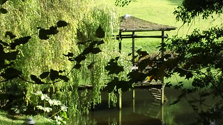
Japanese pavilion
They could have filmed Bridge on the River Kwai here perhaps.
Oct-13 • magyardave2002 on Flickr
book1 walk16 walkicon swcwalks 10230061236

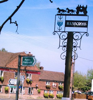
Handcross
Follow the signs. D.Allen vivitar 5199 5mp
Jan-06 • magyardave2002 on Flickr
book1 walk16 swcwalks 467581840

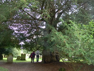
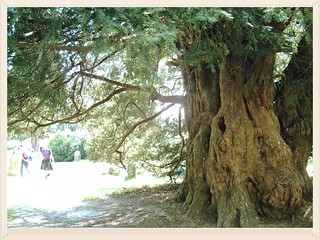
'Yew so ancient!'
800 year old Yew at St Mary's Parish Church Slaugham; even older than some Ramblers. D.Allen Vivitar 5199 5mp
Mar-07 • magyardave2002 on Flickr
book1 walk16 swcwalks 13510514315
Balcombe round/circular
800 year old Yew at St Mary's Parish Church Slaugham; even older than some Ramblers. D.Allen Vivitar 5199 5mp
Apr-07 • magyardave2002 on Flickr
book1 walk16 swcwalks 467581842
The gardens of Nymans & the ruins of Slaugham
| Length | 19 km (11.8 miles),5 hours. For the whole outing, including trains, sights and meals, allow 10 hours. |
|---|---|
| Toughness | 5 out of 10. |
| OS Maps | Explorers OL34 (was 134) & 135 or Landranger 187. Balcombe, map reference TQ 306 302, is in West Sussex, 7km south-east of Crawley. |
| Features |
This walk is full of small delights: a nature reserve and lake with Japanese pavilion down by the stream below the impressive gardens and park of Nymans (National Trust) with its part-ruined manor house; a churchyard in Slaugham (pronounced 'Slaffam') with a 600-year-old yew tree some 10 metres in circumference; the ruins of Slaugham Manor; then a walk down to the River Ouse – with the incongruous sight of a Roman arch and columns in the middle of nowhere – and later up through fields and woods to the fine old village of Balcombe. |
| Walk Options | The second half of this walk is less interesting in some ways, with a fair amount of road and track walking, so you could go as far as the Victory Inn in Staplefield and catch Metrobus 271 to Haywards Heath or Crawley. You can also catch this service earlier in the walk, from the Red Lion pub in Handcross. For bus information, call 0871 200 2233. |
| History |
The Japanese pavilion in the nature reserve was designed by Lord Snowdon, the owner of this country estate.. Nymans (tel 01444 400 321) is a National Trust garden. Ludwig Messel, who bought Nymans in 1890, sought to show that a more exotic range of plants could survive outdoors in Sussex than previously thought. Its manor house was part-gutted by fire in 1947, when huge slabs of the Horsham stone roof fell through three storeys, and the firemen were hampered by bitterly cold weather – ladder extensions and standpipes froze. The garden has a balconey setting, on top of a hill overlooking a valley. A visit is recommended. Nymans is open daily from 10 am to 5 pm, although the house is closed from November to March. Admission (2024) is £16.00 which includes a ‘free cup of tea or coffee in the Welcome Cafe when arriving on foot or by public transport’. There is no entrance fee for National Trust Members. In addition to the licensed Welcome Cafe , open 10 am to 5 pm with lunch served from 12 noon until 2.30 pm, there is a refreshment kiosk - the Horsebox - in the grounds, plus an ice cream kiosk. And new from 2022, within the house, is a new cafe, The Riding House tea room, with views over the estate: open Thursday to Sunday from 11 am until 3 pm. St Mary's Parish Church, Slaugham, has a Norman font made of Sussex marble with a fish symbol on it. There is a brass in the church to John Covert, who in his will left 200 marks to his daughters, even if they married without consent to men without land – but only if the men ‘have virtue and cunning which seemeth as good as 100 marks' worth of land’. Slaugham Place, now in ruins, was once a great Elizabethan manor house. It was the residence of the Covert family, who in the sixteenth and seventeenth centuries held land extending from the English Channel to the banks of the Thames. It is now a popular venue for wedding receptions, complete with helicopter landing space. |
| Travel |
Take the train nearest to 10.00am from London Bridge Station to Balcombe. Journey time 40 minutes. On Sundays the service is from Victoria; journey time 50 minutes. Trains back from Balcombe are twice hourly weekdays and once an hour at weekends. If driving, Balcombe Station has a small car park, free on weekends and Bank Holidays). |
| Lunch |
There is one open pub in Handcross, The Red Lion (tel 01444 400 292) (a Mitchells & Butler pub),is some 5.6 km into the walk. Lunch is served all day, 7 days a week, from 12 noon. Nearby, what was the second pub in the village, The Royal Oak Inn, CLOSED in December 2020 and was due to RE-OPEN late summer 2022 under new ownership on completion of refurbishment (but website states still "temporarily closed" January 2024). From the outside it looks very dead. Within Nymans you have a typical NT cafeteria, and a new (for 2022) tea room in the house, plus a food kiosk and an ice cream kiosk in the grounds. What was the Chequers pub in Slaugham, which closed down in Summer 2017, reopened in September 2019 as The Heritage (tel 0144 401102) an upmarket, award winning restaurant owened by celebrity Chef Director Matt Gillan, some 7.6 km inte walk, and open Thursday to Sunday (closed Monday,Tuesday and Wednesday). They usually have a set lunch menu but their speciality is a multi-course tasting menu. Although this restaurant is probably too expensive and too formal for a SWC walk, the staff are friendly and they do not turn away guests in walking attire. Booking 3 months ahead is required for a weekend reservation ! For a late lunch, 12 km and 3 hrs plus into the walk, you have the option of two very good pubs in Staplefield. You first come to The Victory Inn (tel 01444 400 463) in Staplefield. Open for lunch on Thursday to Sunday, from 12 noon to 3 pm on Thursday, Friday and Saturday, and and until 5 pm on Sundays, in comfy internal dining areas plus extensive outdoor seating. On the other side of Staplefield Green, some 300 metres north of the Victory Inn, on the B2114 road (Handcross Road) you have The Jolly Tanners (tel 01444 400 335), a family run village pub with a pleasant beer garden. Open for lunch seven days a week, reports of its classic pub grub food are very good, and this is the lunch stop on this walk for lovers of real ale, with a choice of up to six ales on offer for the discerning beer drinker (of which there are many in the SWC). |
| Tea |
The recommended tea place is the Balcombe Tea Rooms (tel 01444 811 777), which offers a good selection of home-made cakes. But it closes very annoyingly early (at "tea time") and often before 4 pm, so too early for many SWC walks. Stronger fare is on offer at the nearby Half Moon (tel 01444 811 582), a community-run pub. Drink prices are very reasonable. |
| Updates |
Please use the online version which uses a pedestrian tunnel to cross (go under) the A23 (motorway). It opened after the publication of the 2011 edition of the TO Book. Updates: This edition - Book check and walk uodate January 2024. Historical Note: When the A23 became too dangerous to cross, the walk was diverted along roads, crossing it on a road bridge. In 2014, the road was upgraded to a motorway, and a new pedestrian tunnel was opened on the route of the old public footpath. So now the walk is back to its original route. |
| Book |
This walk was originally published in Time Out Country Walks near London volume 1. We now recommend using this online version as the book is dated. The book contained 53 walks, 1 for every week of the year and 1 to spare. Here is our suggested schedule |
|---|---|
| Profile | |
| Help Us! |
After the walk, please leave a comment, it really helps. Thanks! You can also upload photos to the SWC Group on Flickr (upload your photos) and videos to Youtube. This walk's tags are: |
| By Train |
Out (not a train station) Back (not a train station) |
| By Car |
Start RH17 6JQ Map Directions |
| Amazon | |
| Help |
National Rail: 03457 48 49 50 • Traveline (bus times): 0871 200 22 33 (12p/min) • TFL (London) : 0343 222 1234 |
| Version |
Feb-24 Marcus |
| Copyright | © Saturday Walkers Club. All Rights Reserved. No commercial use. No copying. No derivatives. Free with attribution for one time non-commercial use only. www.walkingclub.org.uk/site/license.shtml |


Walk Directions

- [1] Coming off the train from London at Balcombe Railway Station, go over the footbridge and down the platform on the other side. Exit to the right just before the tunnel, then go through the car park, due south.
- Where this approach road meets the B2036, take the signposted footpath to the right, downhill and heading south-west. In 15 metres cross a stile and in 20 metres cross another, to go down steps (which are very slippery in wet weather, so make use of the handrail on your left), to come out onto a lane at the bottom.
- Carry straight on (slightly left) towards a cottage for 25 metres (over a stream) and [2][!] take the a signposted footpath to the right, through a metal swing gate, heading north-west.
- Go uphill near the field edge on your right-hand side. In 60 metres go through an open fieldgate or through the wooden swing gate to its right and continue steadily uphill. In 125 metres go over a stile at the top of the field and bear left , now with the field edge on your left-hand side.
- In 125 metres go through a field boundary and continue ahead (note the communication tower disguised as a tree on your right). This brings you in 175 metres to a car-wide unasphalted road.
- Continue along the road, still heading north-west. In 70 metres, just beyond a large wooden shed, take the road fork to the left following the footpath sign, heading west.
- Keep on this road, ignoring other possibilities. In 170 metres bend left with it (ignoring a signed footpath off to the right). You pass a pond on your right-hand side, then a house on your left, but keep on towards the barn sheds. When you reach these, veer to the right of the large shed ahead of you.
- In 125 metres keep to the main farm track as it bends right, then in a further 125 metres follow it round to the left.
- In 175 metres, 10 metres before your farm track is about to reach the first trees of the wood, [!] fork left, your direction due south, on what is soon a footpath parallel to the farm track. (This is the official path, although simply staying on the farm track for the next 75 metres would bring you to the same place.)
- [3] In 75 metres go over a stile and turn right by a three-armed footpath sign, into a large, open grassy field, with the edge of the wood now to your right, gently downhill, your direction 240°.
- In 150 metres you have, at least in winter, a pond below you on your right, and you bear right, still keeping the edge of the wood on your right-hand side.
- In 250 metres go over a stile with a metal fieldgate to its right (the horse jump which used to be here has gone) and with a small pond beyond, and continue on in the direction shown by the footpath sign, still with a line of trees on your right-hand side.
- In 150 metres cross a stile next to a horse jump to continue down a path into the woods.
- In 75 metres, at a path junction, bear left following the footpath sign on a wider path, but in 20 metres [!] turn right downhill, in more or less your previous direction, now 240°. Go down steps (with a wooden railing on your right-hand side) to cross a stream on a two plank bridge with wooden railing and follow the path up steps on the other side.
- Keep steadily uphill as the path swings to the right, with the stream down below you on your left-hand side, and some 100 metres from the footbridge, at the top of the slope turn left at a T-junction with a wider track, then in 10 metres veer right towards a gap in the hedge 30 metres away. Go through this gap, cross a tarmac road and head straight ahead on the entrance drive to Ditton Place (marked on the OS map), your direction now 260°.
- In 250 metres, after passing the "Waterside" development on your left, and when still 60 metres from the main building, bear left on a car road following a footpath sign on your right-hand side, your direction now 240°.
- 100 metres down this road, [!] go through the metal kissing gate on your right-hand side to continue downhill through a grassy field in more or less the same direction, now due west, with the field edge on your left-hand side.
- In 175 metres go through a metal kissing gate and head down into a wood, soon bearing left on this path which runs parallel to the stream and pylons on your right. This path has a very uneven footbed and care should be taken when descending it, particularly in winter when the path can be a mini-stream or muddy. In 200 metres cross the stream on a wooden two plank bridge to continue southwards, now on the opposite bank.
- [4] In 30 metres, by a two-armed footpath sign, take the right-hand fork uphill, your direction 210°. In a further 50 metres, at the top of the slope, bear left following the footpath sign.
- In 125 metres, exit the wood over a stile. An unofficial path cuts diagonally across this grassy field to the far right-hand corner, but the public footpath turns right and goes around two sides of the field. Either way, exit the field by a metal fieldgate and turn right to pass under electricity cables. In 60 metres continue through another metal fieldgate (usually propped open).
- In 40 metres go through a wooden swing gate, down a few steps to turn left onto a concrete farm lane, as shown by a footpath sign, to head south-west.
- In 80 metres you come to a junction in the farm track; go across this, turn right for 10 metres , then go left on the footpath by the three-armed footpath sign. Go through a metal gate (usually open) to continue on a wide grassy path, downhill, your direction 240°, with a wooden fence on your right-hand side.
- In 100 metres cross a stream on two planks, then go through a wooden swing gate to continue with the field hedge on your right-hand side, your direction now 300°. Where the hedge ends, continue across the grassy field towards the left of the house ahead of you.
- At the end of the field, go through a wooden swing gate and head down steps into a wood. Continue along a boardwalk to pass Lord Snowdon's lake with Japanese pavilion on your right-hand side. Cross a footbridge over a stream and go up to a T-junction with a car-wide track.
- Turn right here, following the footpath sign, to head north-west. In 45 metres merge with a track from your left and continue ahead, soon with another large lake on your right (you are now on National Trust land, part of the Nymans estate).
- [5] In 200 metres you pass a footbridge on your right (which follows the Millenium Walk) and in a further 100 metres you come to footpath posts on your right. Here, leave the Woodland Walk which continues straight on and instead ! take the footpath fork uphill to the left. This path is infact a broad earthen track which soon bends to the left, with a valley below you to the right.
- Follow this attractive track through the woods for 750 metres, ignoring all ways off, with a gorge down below on your right. After climbing gently uphill, a wider path merges from the left. Now cross a streambed with wooden handrails on both sides and then in 10 metres [!] fork left on a narrow path uphill, as indicated by a public footpath sign.
- Cross a bridge with handrails and keep ahead, climbing steadily uphill. In 200 metres, having gone up a flight of steps on the way, you cross a farm track to continue uphill, now more steeply. (A gate off to the left here would take you into Nymans gardens, but visitors, even National Trust members, are expected to use the official entrance further on.)
- After 200 metres of steep ascent you come to Nymans car park. If you wish to visit the gardens or the NT restaurant, go through the wooden fieldgate on your left and up to the entrance. Otherwise, continue for another 100 metres to the B2114 and turn right to reach a possible lunch stop, the Red Lion, at the road junction.
- The onward route here is to turn left on to the B2110, signposted Cowfold and Horsham (if coming out of the pub, turn right). Cross the bridge over the A23, continue past All Saints Church and keep ahead on the B2110 at the mini-roundabout, now signposted to Lower Beeding.
- [6] In 125 metres, just past The Royal Oak Inn on your right-hand side, (probably CLOSED and not trading as of January 2024) ! turn left up a driveway with a concrete public footpath marker. Some 45 metres up this path, follow it round to the left, past allotments on your right. In 50 metres, bend right with the path in front of a hedge, then in 30 metres go through the remnants of a broken wooden swing gate and continue ahead between hedges, your direction 140°. In 60 metres you come out on to a car lane, with the entrance and large car parking area to North Lodge directly ahead of you, and turn right, initially heading south-west.
- Continue on this lane, ignoring turn-offs. In 500 metres you pass a couple of practice starting gates for horse races, then in 225 metres detour around a set of iron gates to continue on the lane.
- In a further 500 metres, go through a side gate to the right of a large white-painted gate blocking the lane to enter the village of Slaugham. In 125 metres you come on your right-hand side to The Heritage up-market restaurant (formerly the Chequers Inn).
- Keep ahead past the restauarnt to cross a minor road and go through the lychgate into St Mary's Parish Church. Go past the west door and veer left, ignoring a footpath which continues straight on. Just past the south door entrance, veer right on a path through the churchyard, soon passing the 600-year-old yew tree on your right-hand side.
- Where the gravel path ends, continue ahead, slightly left, on a grassy path and leave the churchyard through a wooden swing gate, entering Church Covert (owned by the Woodland Trust). Follow the footpath sign half-right downhill across a field, heading south-east, with the ruins of Slaugham Place ahead on your left.
- In 180 metres go through a wooden kissing gate, beside a two-armed footpath sign and keep ahead on a path between fences, your direction now 160°, with the ruins on your left-hand side. In 85 metres veer right with the path to circumvent the garden of the cottage ahead of you.
- On the other side of the garden, cross a wooden bridge over a stream and go up to join Moat House's driveway. Continue ahead, with the stream and ruins to your left. In 100 metres you meet a car lane.
- There is now no need to detour to avoid the dangerous crossing of the A23 as the new underpass under it has at last opened.
- [7] Do not turn left along the private road, but instead, by a marker post, cross this road then a track to go through a metal kissing gate, following the direction of a two-armed footpath sign, ahead up a grassy field, following its right-hand edge with a wood on your right. In 70 metres the path swings slightly right but you keep ahead your bearing now 100 degrees, as you head over the field to its far side.
- In 110 metres cross two stiles, 3 metres apart, into the next field. Keep straight ahead with a post and wire fence to your right. In 120 metres, at the far end of this field, turn right , parallel to the A23 road / motorway down below you.
- In some 70 at the end of the fenced-in path ! turn left through a wooden swing gate to descend a flight of steep concrete steps with a metal handrail, and down to the surfaced cycle path beside the A23. Turn right along this path and in 15 metres fork right on a tarmac path to descend to the underpass, which you turn left to go through.
- On the far side of the tunnel, turn right and follow the path uphill. At the top, the path swings left through a wooden fieldgate and you keep ahead towards a wooden fenceline to join a grassy path to the immediate right of this fenceline (which fences off a deep water chanel down below to your left).
- In 85 metres go through a wooden swing gate into a field. Follow the direction of the footpath disc on the gate, half-right over the next grassy field on an indistinct path. You are aiming for a partially hidden metal kissing gate in the top right-hand corner of this field.
- In 115 metres go through the gate and then head downhill along the left-hand side of a field, with a hedgerow to your left. In 95 metres, at the bottom of the slope, go through a metal kissing gate and continue ahead, curving left then right with the field boundary, uphill.
- In 70 metres, at the top of the slope, go through another metal kising gate and keep ahead, now with the farm buildings of Stanbridge Grange farm on your right-hand side. In 45 metres pass through a metal farm gate, now painted black (previously white), and keep ahead, along the farm drive, passing on your left a pair of semi-detached cottages, and in 60 metres you to come out onto a minor road.
- Turn left along this road, your direction 25°. In 220 metres you pass the gated entrance to Stanbridge House on your left-hand side. In a further 150 metres the road crosses a stream.
- In a further 30 metres, ! [8] turn right, to follow the direction of a footpath signpost, passing through a metal fieldgate. Follow the footpath over the field, with a stagnant stream on your left, your direction 100°. In 150 metres cross two, two plank bridges and over the stile attached to the second bridge, and bear left , your direction now 50°, into the next field, with a hedge on your left-hand side.
- In 180 metres [!] turn left through a gap in the hedge to pass through a wooden swing gate. [!] Do not turn right but keep ahead, slightly left , through a gap where there used to be wooden kissing gate, to go along the right-hand edge of a grassy field, with a hedge on your right. Keep ahead, on a bearing of 335°, and in 525 metres exit the field, and come out onto a car road, opposite a village green, where you turn right.
- In 100 metres you come to the Victory Inn on your right-hand side, a posible late-lunch stop. In a further 50 metres, you cross the B2114, Handcross Road to continue straight on, uphill ( unless you want another late-lunch option: turn left on this road for 300 metres and you come to the Jolly Tanners pub). Otherwise, in 175 metres, you pass St Mark's Church (which is usually locked) on your left-hand side.
- 300 metres beyond the church, you pass Jasmine and Heron Cottages on your right-hand side, to keep on the main road. In a further 190 metres, ignore Rose Cottage Lane to your right and stay on the road, signposted Balcombe.
- [9] In a further 250 metres – and a few metres past the entrance drive to Tyes Place (marked on the OS map) - and by a footpath sign on your right – turn half-right into the driveway of North and South Meadow Cottages, heading south-east.
- In 80 metres you pass the cottages and bear left with the driveway. Pass to the right of Old Hall Farm Cottage and take a narrow path half-right to exit its garden into a large open field. Bear left , following the footpath sign, to head east along the left-hand edge of this field, between fences, gently downhill. The intriguing castle-like Old Hall is away to your left (but mostly hidden behind trees), with its own mini-crystal palace beyond it.
- In 300 metres, having curved right with the field edge (unfortunately the arch with Roman pillars in the field to your left is now hidden from view.) In a further 40 metres, at the bottom left-hand corner of the field, go left through a gap in the hedge into a lightly-wooded area and follow the path to the right.
- The path - very muddy in places for much of the year - soon has the River Ouse on its right. In 400 metres, cross the river by a wooden bridge, then go through a metal swing gate, following the footpath sign.
- Head uphill on the other side, on a grassy way, between fences, your direction 150°, towards a wooden swing gate in the hedge near the top of the field. In 65 metres go through this gate (off its hinges January 2024) and continue along another fenced-in path for 100 metres to reach Sidnye Farm (marked on the OS map).
- At the farm, bear half-left, following the footpath sign. Cross over the farm's concrete apron and in 25 metres, at a three-armed footpath sign, bear left , passing the large corrugated iron shed on your right-hand side and heading due east. Veer slightly left around another farm shed to go straight on past two cottages on your left-hand side.
- Keep on the farm's driveway. In just under 1km, you come to a T-junction with Cherry Lane, where you turn left downhill.
- In 180 metres you pass the entrance to Hillside on your left-hand side and, in a further 120 metres, you cross the River Ouse.
- Instead of bending right with the lane here, go into the field on your left to continue straight on uphill (due north, towards a red-brick house visible on the horizon), with the field edge on your left-hand side.
- In 250 metres you come up to a lane. Turn left here and then in 15 metres turn right up a narrow path, passing a redundant stile to continue northwards in a large field.
- In 250 metres [!] bear right through a wooden swing gate to continue uphill towards a stile in a hedge. In 80 metres cross a two-plank bridge, go up three steps to cross this stile in the hedge and bear left uphill , keeping the hedge on your left as you pass the red-brick house over to your left.
- In a further 250 metres, you come to the brow of the hill (with fine views behing you). Continue for 50 metres with a hedge on your left, then go gently downhill on a car-wide track into Pilstye Wood. 50 metres into the wood, you pass an impressive rock outcrop split by tree roots on your left-hand side.
- [!] In another 50 metres, an earth car road merges from the right but instead of joining this, follow a footpath sign to take a narrow track [!] opposite and slightly to the right, now going more steeply downhill. In 40 metres, bear right with this path to follow the direction of a footpath sign, north-east, heading downhill and with a new plantation on your right-hand side.
- In 200 metres exit the wood by a narrow pedestrian wooden bridge with wooden railings over a stream, to go up steps and through a metal kissing gate. Here the footpath sign points straight uphill (due north), but if the field is planted with crops with no clear path through them, you may be invited - by the placing of wire fencing - to detour to the left to go around the field edge, first left, then right.
- On the far side of the field do not go through the metal fieldgate but take the stile to its right, to go on a narrow, undulating earthen path, with a fence on your left and woodland sloping away to your right. In 60 metres you come out on to a main road, the B2036, where you turn left, due north, along its verge. In 75 metres you pass a house on the other side of the road.
- You can shorten the walk here by continuing ahead on the B2036, crossing a small grassed area to then take the footpath ahead of you which runs parallel to the road, which in 500 metres comes out at the entrance to Balcombe Station's car park.
- For the main route through Balcombe village (with its pub and tearoom), cross this busy road carefully and go up a tarmac lane, following a footpath sign, your direction initially 140°.
- In 100 metres you enter the drive of Kemps House (marked on the OS map), with the house on your left-hand side. Having gone through a wooden field gate and passed the house, bear right to leave the property by a wooden gate, heading downhill. A path brings you in 50 metres to a metal footbridge over the main London–Brighton railway line.
- Cross over the railway bridge and on its far side continue up the path, parallel to the tracks. At the top go through a metal kissing gate and bear right, with the field edge on your right-hand side, towards the houses ahead, due north.
- Once by the houses, follow the footpath sign along the right-hand edge of a small terrace. Cross a tarmac road into a cul-de-sac, Jobes. Where this road bears left, go slightly right on to a tarmac path between hedges, heading north, with gardens on your left-hand side.
- In 100 metres continue on, now with playing fields on your left-hand side. At the far end of these, continue on a tarmac lane past a pavilion and Balcombe Parish Church Room on your left-hand side. On reaching a road, turn left.
- At a T-junction in 75 metres, either turn right for the Half Moon pub or bear left and cross the road to the recommended tea place, the Balcombe Tea Rooms.
- To get to the station, continue down the road past the tearoom, reaching London Road in 180 metres.
- Here you can go directly to the station by turning left on to this main road, reaching the station entrance on your right in 350 metres.
- For a more pleasant but circuitous route, cross straight over London Road to continue down Rocks Lane, your direction 210°. Keep on this road as it passes under the railway bridge after 300 metres.
- In a further 300 metres, you come to a T-junction by a stream, where you turn left, following the footpath sign. Go up the steps you came down at the start of the walk and turn left at the top into the approach road to reach Balcombe Railway Station. Trains to London leave from the near platform.