Cookham to Maidenhead walk
A figure of 9 - Up over Winter Hill, overlooking the Thames Valley, then along the Thames Path.


Stanley Spencer, The Wind in the Willows and Cliveden
| Length | 16.81 km (10.45 miles), 5 hours. For the whole outing, including trains, sights and meals, allow 9 hours. |
|---|---|
| Toughness | 3 out of 10. |
| OS Maps | Explorer 172 or Landranger 175. Cookham, map reference SU 886 850, is in Berkshire, 4km north of Maidenhead. |
| Features |
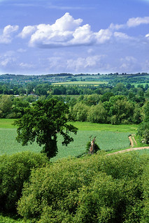
This is a figure of 9 walk, looping around the hills above Cookham with views over the Thames Valley, before returning to it for lunch. The afternoon follows a pretty stretch of the Thames Path to Maidenhead. This walk replaces the original TO Book 1 Walk 24 - Cookham (round) walk - which had difficulties with a lunch pub and a road crossing. You start with a circuit of Cookham, heading westwards from the town and passing the very ordinary house where the artist Sir Stanley Spencer lived and worked for some 15 years until his death in 1959. After passing through Cookham Dean you go past a large free-range turkey farm and into Bisham Woods, where an attractive stretch along an escarpment with fine views over the Thames Valley leads to Winter Hill. Mole, Ratty and company of The Wind in the Willows fame inhabited the riverbanks and wild woods around here, at least according to their author Kenneth Grahame who lived nearby. From here you drop down to the Thames to return by the river to Cookham for lunch, with the opportunity to visit the Stanley Spencer Gallery. After lunch you head south on a particularly attractive stretch of the Thames Path, with the hanging beech woods of the Cliveden Estate on the other side of the river. On the outskirts of Maidenhead you go past Boulter’s Lock, a popular spot to watch the river traffic. |
| Walk Options |
You can shorten the walk by returning to Cookham Station, making a Circular Walk of 11.3km (7 miles). 2km before Cookham, you could cross the Thames by the railway bridge to catch a train back from Bourne End. A shorter route into Cookham (saving 1.3km) is also described in the Walk Directions. In addition to the walk-ending in Maidenhead, an alternative walk-ending in Taplow is shown after the main Walk Directions. |
| History |
Cookham was inhabited by ancient Britons, Romans and Saxons, and in the Doomsday Book is listed as containing ‘32 villagers, 21 cottages, 4 slaves, 2 mills, 2 fisheries and woodland at 100 pigs’. In 1140, a Norman church was built on the site of Holy Trinity Church, Cookham. There is a memorial stone to the artist Sir Stanley Spencer in the graveyard. Spencer was born in 1891 in a Victorian semi-detached house called Fernley in Cookham High Street. He lived and worked from 1944 to 1959 in a house called Cliveden View (passed on this walk) and attended services at the Wesleyan Chapel in the High Street which is now the Stanley Spencer Gallery (tel 01628 471 885). From Easter to October the gallery is open daily 10.30am to 5.30pm; in winter, Thursday to Sunday and bank holidays only, from 11am to 4.30pm. There is an admission fee (2024) of £7.00. The grade I listed Cliveden was built in 1851 in Italianate style by architect Charles Barry for the 2nd Duke of Sutherland and was later owned by the Waldorf and Astor family. From the 1920s it became the centre of high society, culminating with the notorious Profumo affair in the early 1960s. The house is now a luxury 5-star hotel. The grounds, now owned by the National Trust (tel 01494 755 562), were laid out by John Fleming in 1855 and contain an extensive collection of sculptures. There is limited access to parts of the house and its chapel on Thursdays and Sundays, by guided tour only, April to October, cost (2024) for non-NT Members is £2 in addition to gardens fee. The gardens are open daily from 11am until 5.30pm (summer), 5pm (spring and autumn) and 4pm (winter); admission fee (2024) to whole estate £17.00. |
| Travel | Take the train nearest to 9.45am from Paddington Station to Cookham, changing at Maidenhead. Journey time 48-58 minutes. Senior walkers with Freedom Passes have the option of travelling on the Elizabeth Line from Paddington to Maidenhead free of charge. They just need to pay for an off-peak single ticket from Maidenhead to Cookham (or return to Cookham if concluding your walk here). If you plan to have an early lunch stop at Cookham Dean on the short Circular Walk, leave an hour later. There are four trains an hour back from Maidenhead (two on Sundays). Journey time 44 minutes. Return trains from Cookham are hourly. Non Elizabeth Line travellers should buy a day return to Cookham. |
| Lunch |
Late starters doing the Circular Walk could take an early lunch at the Jolly Farmer (tel 01628 482 905) in Cookham Dean, some 2.2 km into the walk, where good food at reasonable prices is served from noon to 2.30pm every day. This walker-friendly pub is often busy and groups over 6 are requested to phone ahead. Another option in Cookham Deane is The Mole & Badger (tel 01628 482 638),a restaurant, bar & wine emporium, serving breakfast, weekend brunch, and lunch (weeekends only) on Saturday from noon until 3.30pm and Sunday roasts from 12.30pm until 4pm. Before reaching Cookham Town you have the option of stopping on the River Thames at The Bounty pub, Cock Marsh (tel 01628 520 056) with its front garden overlooking the river, open from noon until 6pm in summer and until dusk in winter. This pub serves basic pub grub and a variety of beers from its beer tent in a pleasant setting. The suggested place for lunch in Cookham is the Kings Arms (tel 01628 530 667) in the High Street, some 10 km into the walk. A varied food menu offering good value is available all day from noon until 10.00pm (9.00pm on Sundays). Alternatives in Cookham include The Ferry (tel 01628 525 123), which has a fine patio overlooking the river, and another pub-restaurant, Bel and the Dragon (tel 01628 521 263), situated in a 15th century building. |
| Tea |
If you are doing the Circular Walk and returning to Cookham, two suggestions for tea on the High Street are Infusions (tel 01628 528 537), a delicatessen with a garden where you can eat your purchases, and Culinary Aspirations (tel 01628 523 904), a nice tea-room with a splendid selection of cakes which is open until 4.30pm, Tuesday-Saturday. Any of the town’s pubs listed above would also make a good tea stop. Finally, there is an attractive tea place near the station, Station Hill Deli (tel 01628 522 202), but it closes early at weekends (Sun 1.30pm, Sat 3.30pm, otherwise 5pm). On the way into Maidenhead a particularly attractive place to stop for tea is the up-market terrace bar at Boulter’s Lock (tel 01628 621 291), which serves cream teas. Further along the A4094, a more prosaic alternative is Jenners Café (tel 01628 621 721) in the Riverside Gardens, which is open until 5pm in summer but may close as early as 3pm in winter. The recommended route to the station bypasses the somewhat unattractive town centre, but if you choose to take a direct route through the town you will come across many pubs, cafés and coffee shops, some with a few outside tables. There is also a refreshment kiosk on the station platform. |
| Updates |
No major changes. Last full walk check December 2022. Minor updates February 2024. [Pre 2011 editions] Almost a new walk - use the online version. This walk incorporates most of the Cookham (round walk) – the original Walk 24 in earlier editions of this Book – and adds an extension along the Thames Path to Maidenhead. The original route was blocked by a new dual carriageway. The only way to cross it was via an often waterlogged storm drain. And the lunch pub in Bisham became an expensive restaurant that turned away walkers. |
| Book |
This walk was originally published in Time Out Country Walks near London volume 1. We now recommend using this online version as the book is dated. The book contained 53 walks, 1 for every week of the year and 1 to spare. Here is our suggested schedule |
|---|---|
| Profile | |
| Help Us! |
After the walk, please leave a comment, it really helps. Thanks! You can also upload photos to the SWC Group on Flickr (upload your photos) and videos to Youtube. This walk's tags are: |
| By Train |
Out (not a train station) Back (not a train station) |
| By Car |
Start SL6 9BP Map Directions Return to the start: Finish SL6 1EW Map Directions Travel to the start: |
| Amazon | |
| Help |
National Rail: 03457 48 49 50 • Traveline (bus times): 0871 200 22 33 (12p/min) • TFL (London) : 0343 222 1234 |
| Version |
Feb-24 Marcus |
| Copyright | © Saturday Walkers Club. All Rights Reserved. No commercial use. No copying. No derivatives. Free with attribution for one time non-commercial use only. www.walkingclub.org.uk/site/license.shtml |


Walk Directions

- [1] Coming out of Cookham Railway Station turn left. In 15 metres turn left again over the level crossing. In a further 25 metres, with a Costa Coffee shop ahead of you, turn left into High Road, following it round to the right in 60 metres.
- Ignore ways off. In 300 metres you pass on your left-hand side Cookham Rise Primary School (note the three statues of unsmiling children on its forecourt), then a library. In 50 metres ignore Worster Road to the left. Cliveden View, the house on the corner, is where Sir Stanley Spencer lived and worked.
- Continue on High Road, soon gently uphill, ignoring ways off. In 380 metres you come to a T-junction. Ignore the footpath sign almost opposite and turn right on this road, due north. The road soon swings to the right.
- In 80 metres, opposite Whyte Cottage [2], as the road heads downhill, turn left on a signposted public footpath, your direction 290°, between wooden fences.
- In 180 metres follow the path round to the left and in 30 metres bear right through a wooden swing gate to cross a large, open field, gently uphill, your direction 310°.
- In 160 metres you reach the far side of the field and keep straight on up the wide, grassy track ahead. 100 metres further on pass between gateposts – there is a fine view back over the valley at this point. In 50 metres you pass on your left-hand side Elm Cottage. In a further 25 metres cross a gravel drive and with Grey Cottage on your left-hand side, keep ahead, to follow the three-arm footpath sign (on your right) along a grassy way, your direction 260°.
- In 60 metres cross a gravel access drive and keep ahead over a broad grassy verge. In a further 60 metres, by a one-arm footpath sign, keep to the path within the grassy verge, parallel to a road 5 metres to your right. In 80 metres, the path joins the road which now curves right, then left. Next bear left at a road junction, signposted to Cookham Dean Church and Pinkneys Green.
- In 25 metres, at a two-arm footpath sign, turn right across the green at Cookham Dean, aiming for a pub sign - The Mole & Badger - your direction 290°. In 120 metres you come to the pub sign, by a multi-directional signpost, and keep ahead , now on a tarmac lane towards the pub-restaurant (an early lunch option at weekends), with the Karma Sanctum on the Green centre over to its left. In 75 metres pick up a footpath to the right-hand side of the pub and head through trees, gently downhill. [3].
- In 100 metres you come to a squeeze stile on your right. (If you want an early lunch option at the Jolly Farmer pub, turn left just before this stile, through trees and bushes, to reach the pub via its back garden in 200 metres. Afterwards, return the same way.)
- To continue the walk, go through the squeeze stile and follow the clear footpath ahead, a broad grassy way, with an open field to your left and a fence on your right, heading west. Soon there are views of a large free-range turkey farm across the valley ahead. In 300 metres, at the bottom of the valley, there is a five-armed footpath post on your right. Keep ahead and in 25 metres you pass to the left of a commemorative stone pillar (Duke of Edinburgh 150th Anniversary award for Nature Conservation, 1991). Now head up a broad grassy way, with a hedge on your right and a fence to the turkery enclosure on your left-hand side.
- In 150 metres, at the far top end of the enclosure, go through a metal kissing gate in the hedgerow and turn left on to a tarmac road. In 40 metres, with a 30 MPH road sign on your left turn right on a signposted public bridleway into Bisham Woods, passing to the right of a wooden fieldgate.
- Walk along the left-hand edge of this wood on a partly-surfaced track, gently uphill. In 400 metres ignore a public footpath to the right, marked by a wooden post with yellow arrow. In 120 metres you pass a wooden post on your right, with blue arrow. In a further 10 metres there are paths branching off on both sides (with a wooden post 5 metres ahead with multiple yellow and blue arrows). [4].
- Fork right here, your direction 320°, and in 12 metres pass through a wooden barrier. Take the wide path ahead through the trees, gently uphill, in 50 metres following it round to the left and downhill towards another wooden barrier.
- Go through the barrier and in 10 metres follow the path around to the right to join a broad track running along the top of the escarpment, your direction 50°. Your way ahead is marked by regularly placed wooden posts, approx 1.8 metres high, with tops pained blue, and as you go along this permitted bridleway there are several places on your left where the trees have been cleared to give fine views of Marlow in the Thames Valley below.
- In 500 metres, just past a marker post with a blue top, the bridleway veers slightly to the right. The narrow, unmarked path on your left is the most direct continuation to Winter Hill but this path is not recommended, as up ahead you would have to negotiate an awkward little stretch of narrow road with no pavement.
- Instead, follow the bridleway ahead (slightly right). In 55 metres you come out into a more open area with a bench seat over to your right. In a further 65 metres you pass on your left another marker post with a blue top. In [!] 5 metres, turn left off the bridleway onto a narrow, unmarked path through undergrowth, your direction 50° [5].
- If you miss this turning, the bridleway comes to a three-way road junction in 200 metres. In this case, take the signposted footpath on the other side of Quarry Wood Road to go between a fence and gardens, your direction 30°. In 120 metres turn left at a T-junction, then in a few metres [!] turn right at a footpath signpost into the woods. Continue the directions at point [6] below.
- The path through undergrowth soon comes out into an attractive part of a beech wood. Keep ahead on the path through the wood, latterly swinging to the left then right, and after some 120 metres you exit the wood through a small car parking area (with a sign "Welcome to Quarry Wood" to your left) to reach a road, with houses opposite.
- Cross the road and with a house called "Dormers" to your right, [!] take the signposted footpath ahead, your direction 100°. In 70 metres [!] turn left at a footpath signpost into a wood (if you reach the end of the fence on your right, you have missed the turning).
- [6] Follow a faint path which meanders through the wood, your initial direction 20°. The path gradually curves to the right, the way being indicated by white arrows on trees. In 170 metres, bear right with the path through some undergrowth. In a further 30 metres you go down a short slope to your right. Continue down the slope and in a further 40 metres you reach a signpost with a footpath coming in from behind you on your left – the continuation of the direct route mentioned earlier.
- Keep ahead, slightly right, with the path, a wire mesh fence on your right and then later a wall. (The slightly spooky wood down on your left is probably the inspiration for the Wild Wood in The Wind in the Willows.)
- In 300 metres the path veers right, joining the gated driveway of Rivendell house. Ignore a path down to the left in 10 metres, but 5 metres beyond this [!] turn left by a post with a yellow arrow to go through light undergrowth to come out into the open and onto a grassy bank as you head towards the parking area for the National Trust’s Winter Hill. There are outstanding views and in summer there is often an ice-cream van here.
- To detour to Kenneth Grahame’s house, go sharp right and follow the main road with a wall on your left and a curious disused letterbox set into it, then in 120 metres turn left into Job’s Lane. In 200 metres you come to a road where you turn right. Up on your right-hand side, in 50 metres, is the author’s old house, now a prep school.
- In 250 metres at the end of the car parking spaces on Winter Hiil, bear left into light woodland and keep ahead now on a woodland path, gently downhill, with the road over to your right, heading north-east. In some 200 metres, and 15 metres before the path rejoins the road ahead, [!] turn left and head down five earthen steps with wood risers. Continue on this winding path and in 65 metres head down another six earthen steps. In a further 70 metres, at a path junction, turn left , downhill.
- In 50 metres you cross two small roads (Gibraltar Lane and Stonehouse Lane) to pick up the continuation of the footpath, a two-arm footpath sign to your right marked Chiltern Way, Berkshire Loop. There is a private road running parallel on your left-hand side. Where the path joins a track, bear left along it. In 150 metres you pass through a metal kissing gate to the left of a metal fieldgate. Ignore paths to both sides and continue down the main car-wide track, with superb views to your left. In 600 metres you reach the valley bottom and a four-armed footpath sign [7].
- To shorten the walk by 1.3km, go straight on at this path junction. In 900 metres you pass under the railway and turn half-right onto a wide path between a ditch and a golf course. In 350 metres, veer left across the grass to join the Thames Path and continue the directions at point [8] below.
- For the main route, turn left at the four-arm signpost, heading north, over a grassy field. In 65 metres, go through a wooden kissing gate and head straight across a vast, open field.
- In 160 metres, at the far side of the field, and by a two-armed footpath signpost, turn right as indicated, your direction 40° along the edge of the field, with a fence to your left. In 240 metres you reach the River Thames on your left-hand side, behind a hedge.
- Your route to Cookham more or less follows the Thames. But in more detail: keep ahead along the field edge and in 300 metres go through a metal kissing gate to the left of a metal fieldgate. Keep ahead over a grassy field, with the river to your left, as your way bears gently to the left. In 190 metres go through a wooden kissing gate and pass houses on your right-hand side, now beside the river with private moorings and jetties on your left. In 120 metres pass (or call in at) The Bounty riverside inn, a walker-friendly pub, a lunch pub option (and one of the few pubs which cannot be reached by road).
- In a further 200 metres go through a wooden swing gate and go under the railway bridge [7A]
- The Marlow to Cookham option joins here.
- In 20 metres go through a metal kissing gate and keep ahead through the National Trust’s Cock Marsh, keeping close to the left-hand edge of a field with treeline on both sides and river on your left and a vast open field over to your right. 500 metres beyond the railway bridge, go through a metal kissing gate to the left of a metal fieldgate. Keep ahead over the next grassy field. In a further 400 metres ignore a fork to the right and in a further 100 metres, and some 30 metres beyond a bench seat on your right, ignore another fork to the right.
- [8] Carry on along the riverside, now with a distant view of Cliveden up on the ridge ahead. In 200 metres you go through a white metal swing gate and past a sailing club on your right-hand side, then another gate.
- In 40 metres ignore a tarmac path to your right and continue alongside Bell Rope Meadow on a tarmac path. In a further 150 metres, at a Thames Path sign, turn right onto a tarmac path, towards the church visible to your right (but if you are going to The Ferry for refreshments, then carry straight on beneath the road bridge up ahead).
- In 50 metres you enter the churchyard of Holy Trinity Church, Cookham, past a metal kissing gate. The church entrance is on the far side.
- Coming out of the church, take the path from the front door, going between yew trees. Spencer’s memorial stone is off to the right of this path, near a wooden bench – his ashes were scattered by his wife’s grave in Cookham cemetery. At the church gates turn left to reach the A4094. Turn right onto this main road and follow it round a bend to the right.
- In 60 metres you come to a road junction, with the Stanley Spencer Gallery opposite. Turn right to go along Cookham’s High Street. On the right is a possible refreshment stop, Bel and the Dragon, while a little further along on the left is the suggested lunchtime stop, the Kings Arms [9].
- If you are doing the short Circular Walk, one of the suggested tea stops, Infusions, is just past the Kings Arms. The other, Culinary Aspirations, is further along the High Street in Cookham Arcade on the right. To get to Cookham Station, about 1km away, continue along the High Street, then across Cookham Moor on the tarmac path to the left of the road. After 300 metres the path rejoins the road and you go along it for a further 500 metres, passing the White Oak and The Old Swan Uppers pubs and then going straight on at a mini-roundabout. You pass Station Hill Deli on your right and bear left to reach Cookham Station.
- For the full walk, continuing to Maidenhead, return to the road junction by the Stanley Spencer Gallery and turn right onto the A4094, heading south. You soon pass on your right-hand side public WCs. Some 200 metres along this road turn left into Mill Lane, signposted as the Thames Path.
- Keep ahead on this lane, passing a cricket pitch on your left. 500 metres from the main road, you come to a group of houses. Opposite the imposing gates to The Sol Mill, fork right down a narrow path, following the Thames Path sign. This soon curves back to the left and almost rejoins the lane, as you cross over a gravel access way and keep ahead through a woodland strip, parallel to the lane just to your left.
- Continue along the signposted path to the right of the lane. In 250 metres the path bends right and you now head south-east along it, still through a woodland strip, for a further 400 metres until you reach the banks of the River Thames , with a bench seat on your left and a gnarled oak tree on your right. [10]. On the far bank of the river are several cottages and boathouses on the Cliveden Estate (the house itself is high up to your left but not visible from here).
- Turn right and now simply follow the Thames Path south, with the river on your left. This is a lovely stretch of the Thames Path, with the wooded escarpment on the far side particularly attractive in late autumn. In 2.4km the path joins the A4094 and shortly after this you reach Boulter’s Lock, an up-market tea stop with a splendid view of the river from its terrace bar. [!] The alternative walk ending in Taplow starts here.
- But continuing to Maidenhaed: from the lock continue south on the A4094. In 500 metres you pass Jenners Café in the gardens on your right, another possible tea stop. In a further 200 metres you pass the River Bar of the Thames Hotel and there is a turning on the right, Ray Park Road [11]. You now have a choice of routes to Maidenhead Station.
- For a more direct route through the town centre, passing many more tea places, turn right into Ray Park Road, heading west. In 500 metres, where the road swings right, bear left briefly into Ray Park Lane and then turn right onto a surfaced path into a grassy open area. Keep to the path along the left-hand side of the open area and in 200 metres turn right to go down an underpass beneath the busy A4. Turn right on the far side of the underpass to head west along Bridge Road and then High Street for some 500 metres. You will find the Wetherspoons pub-restaurant and cafes along the High Street. Where this street becomes pedestrianised, [!] turn sharp left with the road with more shops and cafes on either side. This road soon becomes Queen Street. Cross over the Broadway and some 375 metres from the turn off from the High Street you come to a major road junction with the A308. Make your way via the pedestrian crossings to the far side of this busy road and go up Station Approach to reach Maidenhead Railway Station.
- For the recommended route (which is not possible after dusk as the park gates on this route are locked then) continue on the Thames Path alongside the A4094 for 300 metres to reach a major road junction. Cross the A4 here with great care to continue along Guards Club Road on the other side of the roundabout, heading south.
- In 150 metres, after passing some interesting buildings, enter Guards Club Park through a gate (locked at dusk). You will be leaving the park through a gate on the right 100 metres ahead, by a small car park, but a small detour towards the river on your left will give you a fine view of Isambard Kingdom Brunel’s famous brick rail bridge from the footbridge to Guards Club Island.
- After leaving the park head west along a winding residential road, eventually revealing itself as Oldacres. In 350 metres, at a T-junction, turn left into Oldfield Road. In 200 metres pass under a railway bridge. In a further 200 metres cross a road to take a tarmac roadway ahead of you, signed to Brayrick Park.
- In 100 metres cross a bridge over a small river to take a concrete path, the Green Way, to your right. The river is on your right. In 300 metres the path reaches a road where you bear left, passing Homebase and other stores in Maidenhead Retail Park on your right.
- In 300 metres you reach a major roundabout where you turn right, back towards the railway. Just before the railway bridge use pedestrian crossings to cross the busy A308. Go under the bridge and turn left along a path to reach Maidenhead Railway Station. Trains to London leave from Platform 4 which also has a refreshment kiosk.
Walk ending in Taplow
- At Boulters Lock turn left on a lock bridge and swing left to go past the cafe / restaurant building on your right and at its far end swing right to head down (slightly right) to a new, wooden hump back bridge, with access to Ray Mill Island on your left.
- Cross over this bridge to enter on its far side the landscaped grounds of Taplow Riverside , a 19 acre country park. Turn right and head south on tarmac paths between formal flower beds to enter the new residential development between Jubilee River on your left and the River Thames on your right.
- Exit the development at its far end, turn left to cross over the Jubilee River, ignore the footpath on your right to Maidenhead and head up Mill Lane, with woodland on both sides. After an initial steep section the road levels out and in 325 metres you come to a T-junction with Berry Hill Road. To visit the pleasant village of Taplow turn left here. Otherwise, for Taplow railway station, turn right and head down the road, soon passing Taplow House Hotel on your left and later farms to left and right.
- In 600 metres the road comes out at a T-junction with the busy A4 road. Turn left along its pavement, passing car showrooms on either side and a pub / restaurant on your left which, when open, serves as your walk-end refreshment stop. In 175 metre and just before the railway bridge ahead of you, fork left on Approach Road, and head up this road, following the railway embankment on your immediate right.
- In 560 metres you come to Taplow Railway Station on your right-hand side. The platform for trains to London Paddington is on your nearside.
Marlow to Cookham Option via the Thames Path Option
7.2km (4.3 miles) from Marlow to Cookham
14km (8.8 miles) from Marlow to Maidenhead.
These directions take you from Marlow to Cookham along the Thames Path, where you can link into the above direction, and carry on along the Thames Path into Maidenhead. This is an easy walk along a very pleasant section of the Thames, with plenty of lunch options in Cookham.
Take the nearest train to 10am from Paddington to Marlow
This walk also passes one extra lunch option, the Bounty Inn on the river opposite Bourne End. It serves food 12-8pm from Easter to the end of September, but at other times of the year is open on Sundays only.
- From the single platform at Marlow railway station, walk forward, and up the approach road. Cross Lock Road, to pass The Marlow Donkey pub on your left, and carry on down Station Road.
- In 180 metres ignore Station Rise, a cul du sac, to your left, but shortly afterwards turn left down Mill Road.
- Follow this road to reach the River Thames just by Marlow Weir. Turn left along the road along the river. Ignore a turning to Marlow Lock to the right (unless you want to have a look at it) but carry on along the road.
- In 250 metres look out for a grassy area to the right, where the Thames Path (signposted but not very clearly) turns right to the river bank. When you get to the river bank, turn left along it .
- You now stay on the Thames Path all the way to Cookham. The way is never in doubt, and passes first in about 350 metres under the A404 road bridge, then past sport fields into open meadows, with the railway line to your left. In 3.5 kilometres you come to Bourne End. Here the path threads between the gardens of riverside houses to the railway bridge, where you cross over the river.
- On the far side is point 7A.
- For the Bounty Inn, turn right along the far river bank to find the pub in 200 metres, afterwards, retrace your steps
- Otherwise, to continue to Cookham, turn left on the far side of the railway bridge. Follow the river path for just over 2.2km (there is more detail in walk directions in book one, walk 24) until, 100 metres before the Cookham road bridge (the next bridge you come to), the Thames Path turns right away from the river into Cookham Churchyard.
- Coming out of the churchyard at its far end, follow the lane to the main A4094 in about 50 metres, and turn right on it. This is Cookham High Street, where there are several lunch options.
- After lunch follow the walk 24 directions to Maidenhead.