Shelford to Cambridge walk
Granchester, the River Cam and the Cambridge colleges.
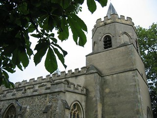
walk 26 01 churchofstmarythevirgininshelford
Jun-05 • Bela Struzkova on Flickr
swcwalks book1 walk26 37152183232

walk 26 03 churchofctedmundsinhauxton
Jun-05 • Bela Struzkova on Flickr
swcwalks book1 walk26 37182129101

Grantchester - the Rupert Brooke walk
| Length |
23.5km (14.6 miles) per GPX, for full route, 6 hours walking. Options to reduce walk length - see below. For the whole outing, including trains, sights and meals, allow at least 11 hours. |
|---|---|
| Toughness |
5 out of 10. |
| OS Maps |
Explorer 209 or Landranger 154. Shelford, map reference TL 465 523, is in Cambridgeshire, 6km south of Cambridge. |
| Features |
This walk is long and flat and gets better as the day progresses after a somewhat dull morning: the route into Cambridge is lovely, particularly after Grantchester. Near the start, to lessen the amount of road walking which faces you today, you may take what is now a “Permissive Path” along a farm track besides the River Cam, from Little Shelford to Hauxton Church: you no longer need the farmer’s written permission in advance to walk along this path, as in bygone times. The route then passes through the village of Hauxton, with its interesting church, then on to Haslingfield for lunch. From there you head to Grantchester and tea in the Orchard tearooms before walking besides the River Cam into Cambridge. Try to conserve enough energy to take the walk’s tour of Cambridge colleges at walk-end. To avoid the less-than-exciting morning, and spend more time exploring Cambridge, a Cambridge via Granchester Circular walk has been devised (see Walk Options below). Whichever walk you choose, please note your tarmac count today will be high and this is telling on the feet. Consequently you may prefer to wear well cushioned trainers instead of walking boots. |
| Walk Options |
You can shorten the main walk by taking the road route from Great Shelford, and by cutting short, or eliminating, the tour of the university colleges towards walk-end. This will reduce the walk length to 12.7 miles or under 12 miles if you head direct to the railway station when entering the city. You can omit the walk's loop through the village of Haslingfield and instead head straight for Grantchester: this cuts out just under 1 km of the walk. You could also take a taxi from Grantchester to Cambridge, or a bus from Hauxton or Haslingfield to Grantchester or Cambridge: for bus information call Traveline on 0871 200 2233. Cambridge via Granchester CircularSWC Walk 105 Cambridge Circular is 15km (9.4) mile version of this walk which cuts out the morning leg of the main walk and allows you more time for the City Centre tour of the University Colleges before you head out to Grantchester on a walk besides the River Cam. You stop for tea at the famous Orchard tearooms, and then you have a choice of a return walk to Cambridge, either via Trumpington or back beside the River Cam. Gardeners amongst you may like to visit the Cambridge University Botanic Gardens at walk end before taking the short walk which remains to Cambridge Railway Station. Directions for the route to Cambridge via Trumpington are included after the main Directions. |
| History |
Writing a famous poem must be as effective a way as any of ensuring that a place is preserved forever. Rupert Brooke’s poem The Old Vicarage – he had rooms as a student at the Orchard, and later at the Old Vicarage, Grantchester – was written in a mood of nostalgia in a Berlin café, in May 1912. The poem celebrates not only Grantchester and the river (‘Laughs the immortal river still/Under the mill, under the mill?’), but the surrounding countryside (‘And sunset still a golden sea /From Haslingfield to Madingley’). Augustus John camped in Grantchester meadows with, as Keynes put it, his “two wives and ten naked children”; Brooke and Virginia Woolf (who dubbed his friends the “Neo-Pagans”) swam naked by moonlight; EM Foster visited the Orchard; Wittgenstein would come there by canoe; AN Whitehead and Bertrand Russell worked on their Principia Mathematica at the Mill House, next to the Old Vicarage. As for the church clock (‘Oh! Yet /Stands the Church clock at ten to three? / And is there honey still for tea?’), in Brooke’s first draft at half past three (the actual time it was stuck at for most of 1911). The Church of St Mary the Virgin, Great Shelford, was rebuilt at the expense of its rector, Thomas Patesley, in the early fifteenth century. This Grade 1 listed building is famous for its Medieval Doom Wall Painting of the Last Judgement . The painting, on the arch to the entrance to the Chancel, shows judging Christ sitting on a rainbow, with the sun to his right and moon to his left. Copious amounts of blood pour from his wounded arms as he extends them towards the Archangels - to his right Michael and to his left (possibly) Raphael. Beyond, to the left, is the Virgin Mary, and to the right, John the Baptiste. Another famous Doom mural can be found in the church of St Peter and St Paul, Chaldon (on TO Walk 2-15: Riddlesdown to Coulsdon). Its impressive Doom shows the Purgatorial Ladder with the Seven Deadly Sins. The mural depicts vivid (quite scary) images of the ways to salvation and damnation. Both churches, on their respective walks, are well worth a visit. St Edmunds Church, Hauxton, is renowned as one of the oldest and most interesting small churches in Cambridgeshire, with Norman windows, doors and chancel arch; a thirteenth-century font bowl; a fifteenth-century pulpit and nave roof. It also contains a rare thirteenth-century fresco of St Thomas à Becket, which survived Henry VIII’s depredations; and, having been previously walled up, this fresco also survived the vandalism of the notorious puritan William Dowsing (who, in 1643, destroyed “three popish pictures” in this church). St Edmund became King of East Anglia in 856 at the age of 15, and was killed 13 years later by the Danes for refusing to renounce his Christian faith. The oldest surviving building in Cambridge is St Bene’t’s Church, which has a Saxon tower. Cambridge University was founded in the early thirteenth century by students and academics fleeing riots in Oxford, where the townsfolk felt imposed on by the academics. Within a couple of centuries, the university dominated the Cambridge townsfolk too: in 1440 Henry VI had a large part of medieval Cambridge demolished to make way for King’s College, intended for students from his new Eton school; in 1496 a twelfth-century nunnery became Jesus College; in 1542 a Benedictine hostel was transformed into Magdalene College; and in 1596 Trinity College was endowed by Henry VIII with funds from the monasteries he had vandalised. The Orchard Tea Rooms date from 1897, although the orchard’s apple trees were planted eleven years earlier. Soon after opening the tearooms became a favourite up-river café of college students. In the tearoom’s early years the owners took in lodgers to supplement their income, one being Rupert Brooke. Today college students punt up to the Orchard for tea – or a champagne breakfast after May Balls. During Cambridge’s Fringe Festival summer evening performances of Shakespeare are held at the Orchard. The Travelling Telescope to the west of Cambridge is built on a section of the former Cambridge to Bedford railway line. Owned and operated by Cambridge University, the telescope consists of a number of large aperture synthesis radio telescopes, the original of which date from 1957. Cambridge University Botanic Garden dates from 1846 and is a 40 acre garden which today contains over 8,000 species of plants from around the world, in a beautifully landscaped setting. Open April to September from 10am to 6pm; February, March and October from 10am to 5pm; and January, November and December from 10am to 4pm. Entrance fee (2023) £ 8 (including gift aid). |
| Travel |
Take the train nearest to 9am from Liverpool Street Station to Shelford. Journey time 1 hour 15 minutes. Alternatively, you can take a fast train from King’s Cross to Cambridge and change there for Shelford (one station back down the line to Liverpool Street). In addition to your day return to Cambridge you will need to purchase a single ticket from Cambridge to Shelford if travelling up from Kings Cross. Trains back from Cambridge run twice an hour to Liverpool Street and up to four times an hour to King’s Cross. Journey time 50-80 minutes. If you travel out from Liverpool Street and intend to return on a fast train to King’s Cross, ask for a (more expensive) ticket which will allow this. |
| Lunch |
The suggested lunchtime pub is the Little Rose (tel 01223-870 618) in Haslingfield, some 7.9 km into the walk. Under new ownership since 2020, this family friendly, local pub serves classic pub grub from midday to 3 pm weekdays and weekends, with roasts on Sunday. It also specialises in draught beer, and has won Camra awards in the past. In bygone years this pub has had a very chequered history, with frequent closures, so no bad thing to 'phone ahead to check they are open and serving food on the day of your planned visit; if not open, you will find a village shop just up the road where you can purchase a selection of snacks for a picnic lunch to keep you going until Grantchester – and tea at the Orchard Tea Rooms. Should you prefer a late lunch in Grantchester, some 15 km into the walk, you used to have a choice of three excellent pubs, and although one succumbed to Covid, all three are now back open. The Rupert Brooke reopened in January 2022 after a period of closure. The Red Lion is fully open, and the The Green Man, which closed its doors for a numbder of years, has been rescued by local intervention from the grasps of propery developers, and is back trading as a pub (June 2023. By all means stop for lunch at one of these pubs, but our suggestion is to have a snack or light lunch in Haslingfield, then tea in the Orchard (see below). |
| Tea |
THE de rigueur tea stop on this walk is The Orchard Tea Rooms (tel 01223-845 788) in Grantchester. It is steeped in history and although touristy, it retains a great atmosphere so it is very popular with Cambridge and local residents as well as the many tourists who flock there. Consequently, at weekends (particularly on Sundays), the Orchard is packed and you will have to queue to be served and wait for a table to become free under the orchard’s apple trees. But be patient as the wait is worthwhile. You may well be in need of a cuppa after finishing the tour of the colleges. You are spoilt for choice for venues in the City Centre. There are also kiosks on Cambridge Railway Station which serve coffee and tea. |
| Updates |
Minor updates July 2017. [Pre 2011 Editions] The farmer's path is now permissive - no need to write in advance. Grantchester pub update July 2023. Book check and walk update January 2022. |
| Book |
This walk was originally published in Time Out Country Walks near London volume 1. We now recommend using this online version as the book is dated. The book contained 53 walks, 1 for every week of the year and 1 to spare. Here is our suggested schedule |
|---|---|
| Profile | |
| Help Us! |
After the walk, please leave a comment, it really helps. Thanks! You can also upload photos to the SWC Group on Flickr (upload your photos) and videos to Youtube. This walk's tags are: |
| By Train |
Out (not a train station) Back (not a train station) |
| By Car |
Start CB22 5LR Map Directions Return to the start: Finish CB1 2JW Map Directions Travel to the start: |
| Amazon | |
| Help |
National Rail: 03457 48 49 50 • Traveline (bus times): 0871 200 22 33 (12p/min) • TFL (London) : 0343 222 1234 |
| Version |
Jul-23 Marcus |
| Copyright | © Saturday Walkers Club. All Rights Reserved. No commercial use. No copying. No derivatives. Free with attribution for one time non-commercial use only. www.walkingclub.org.uk/site/license.shtml |


Walk Directions
- [1] Coming off platform 2 at Shelford Railway Station, from Cambridge, turn right on to the main road, Station Road, your direction 215°. In 40 metres you pass on your left-hand side a new residential development on the site of where once stood the Railway Tavern pub.
- In 115 metres you cross the A1301, Tunwell’s Lane, to continue straight ahead on Woollards Lane, ignoring ways off. You should pass a café or shop open as you proceed through the village if in need of pre-walk refreshments. In a further 325 metres, you come to a T-junction (with house No.90 opposite) where you go left, on Church Street.
- In 160 metres you come to the Church of St Mary the Virgin, Great Shelford, which is well worth a look inside - to see its Doom mural.
- In 50 metres you pass Kings Mill Lane on your left-hand side.
- [2]. Now there are two alternatives: the road route takes you by an interesting church, and this route is shorter in length than the permissive farm track route. However, the latter is more relaxing – and given the amount of tarmac you are facing today, is easier on the feet - and is the recommended route.
- The road route
- Continue on the main road (Church Street). In 125 metres cross a bridge over the river to enter Little Shelford. In 60 metres cross another bridge, and you are now on Bridge Lane with an old red brick wall on your right-hand side. Continue for a further 250 metres to a junction. Here swing right on Church Street, signposted Hauxton and Harston, and in 35 metres you pass on the left-hand side of All Saints Church, Little Shelford (worth a look inside). In a further 250 metres you come to a T-junction by the Sycamore House Restaurant. Here turn right along Hauxton Road.
- Ignore ways off and in 550 metres you pass over a level crossing. In another 250 metres you pass under the M11. In a further 500 metres, you enter the village of Hauxton and pass the bus stop. Continuing along Church Road, ignoring turn-offs, in 440 metres you come to the Church of St Edmunds (worth a visit inside), rejoining the route at point [3] below.
- The permissive farm track route
- Almost opposide Kings Mill lane, turn right through a wooden swing gate, some 20 metres to the right of the entrance into Rectory Farm and proceed up a fenced-in path. In 160 metres the path ends and swings left into a field, beyond a barn over to your left. In 70 metres the path merges with a farm track coming in from the left. You now keep ahead on this track all the way to Hauxton, with the River Cam over to your left, on what is now a Permissive Path (you no longer need the farmer’s permission to walk along it). In more detail
- In 45 metres ignore a fork left to continue on, with treeline on your left and open fields to your right, your direction 310°. In a further 180 metres, just before you reach a gated crossing across the railway line [!] veer left downwards to go through a tunnel under the railway, and come up the other side. Do not try to cross the railway crossing.
- In 150 metres pass through a field boundary and keeo ahead. In a further 600 metres pass through another field boundary and bend with the track to the left to continue on, your direction 260°, still with the river over to your left.
- In 305 metres go under the M11 motorway bridge.
- In 325 metres pass through a field boundary and keep ahead. In a further 400 metres veer right, with a field hedge on your right-hand side, your direction 340°, following the main track.
- In 290 metres you come to some farm buildings on your right-hand side, where you veer left with the road, your direction 315°, towards a pair of cottages. In 170 metres you pass these cottages.
- In a further 175 metres, you come to within 25 metres of the A10. But here you turn sharp left on a driveway, past a wooden fieldgate, on a signposted public footpath, your direction 175 degrees, towards Hauxton Mill building. In 65 metres go over a bridge and straight on. In 40 metres go over a mill stream. At the end of the Hauxton Mill building you go left, your direction 120 degrees, with the river on your left and a new housing development on your right (where once stood a chemicals factory).
- In 40 metres ignore a footpath leading to a wooden bridge on your right (although Note : you can if you wish cross this bridge and walk through the new Hauxton Meadows housing development, coming out onto the A10 road. If you do, turn left along this road until you reach the signposted turning to Haslingfield). Otherwise, continue ahead with the Mill stream on your left. In 480 metres your path leads to a concrete bridge with wooden railings, which you cross to continue on, now with the new housing development on your right-hand side.
- In 200 metres go through the wooden swing gate to your left, your direction 165°. In 20 metres go through a wooden kissing gate, and head along the left-hand edge of a field towards the church.
- In 150 metres you come out to the road and to the Church of St Edmunds, Hauxton (worth a look inside).
- [3] Continuing on the main walk:
- Turn right onto this road (Church Road) from the farm track route or keep ahead on the road route.
- Ignore all ways off as you pass the new housing development – Hauxton Meadows – on your right-hand side. In 300 metres you come to the A10 where you turn left. In 35 metres there is a bus lay-by, with buses to Royston and 50 metres further down the road, on the opposite side, buses to Cambridge. Opposite the nearside bus lay-by, take the public bridleway signposted to Haslingfield, your direction 285°, onto a wide gravel farm track with a large open field on the left.
- In 260 metres ignore a fork to the left towards Rectory Farm (marked on the OS map). In 50 metres ignore another fork to the left, to carry straight on, your direction 300°; the church in Haslingfield is already visible ahead to your left.
- In 180 metres ignore a turning to the right marked ‘Private Road’.
- In 60 metres the earth track becomes grassy. In 200 metres the track swings gently left between vast fields and over a stream, with a small coppice on your left. Keep ahead, on a bearing of 245°. In 150 metres pass through a part tree-lined field boundary. Follow the grassy track with a ditch and field boundary on your right. In 400 metres pass through another field boundary and at a path junction, bear right, your direction 305° now on a gravel path;.
- In 200 metres go on a bridge over the River Cam and turn left, with the river alongside on your left-hand side, your direction 235°. In 230 metres your way merges with a farm track [4].
- In 50 metres the farm track swings left. Ignore the path ahead [[!] unless you wish to bypass the village of Haslingfield and head direct to Grantchester, in which case keep ahead here and in 150 metres, turn right into Cantelupe Road. In 385 metres you keep ahead through Lesanna Farm where the path from the main walk route joins from the left]. Otherwise, the main route continues: bear left with the track and in 30 metres, with playing fields on your right-hand side [!] turn right through a metal gate, your direction due west, along the right-hand edge of the playing fields.
- In 100 metres you pass a thatched cottage on your right-hand side. In a further 100 metres, you come out through metal barriers (with wooden posts) to a road (New Road) where you go left, your direction 200°.
- Stay on this road, ignoring Fountain Lane to the right, coming to the High Street T-junction in 80 metres. Here you go right. In 55 metres go left on Baldock Road and immediately right, to the modern building that is the Little Rose pub, the suggested lunchtime stop.
- After lunch return to the High Street and turn left, your direction 285°. Ignore ways off. You pass the village shop on your right and then Haslingfield’s Village sign. After 330 metres, where the High Street veers left, and some 50 metres past the Village sign, you go straight on, along Church Way, with a pair of thatched cottages on your right-hand side. In 80 metres you come to the Parish church of All Saints, Haslingfield (worth a look inside).
- Coming out of the church door, go straight ahead on a narrow stony path through the churchyard, your direction 340°. In 110 metres you come out to a tarmac road where you continue straight on. In 25 metres you pass the thatched Oak Cottage on your left-hand side. In a further 35 metres, fork right on Dodds Mead. In a further 45 metres, pick up the tarmac path to the left of a house called Adelaide (No.1), straight on, your direction 15°.
- In 85 metres you come out on to a road (New Road) by house No. 118 opposite, where you turn left, your direction 320°. In a further 95 metres, you come out on to Barton Road, with a thatched house opposite where you turn right.
- In a further 175 metres, opposite house No.31, [!] take the signposted public footpath to the right [5], your direction 95° (the pub marked here on old OS maps is long gone).
- In 45 metres go over a wooden footbridge with railings over a stream on a gravel path and in 20 metres dogleg left then right with the path. In a further 60 metres go under mini pylons and in 70 metres the gravel path becomes a wide grassy path. In a further 140 metres cross a farm track and go over a ditch and with a farm gate directly ahead, turn left, your direction 10°.
- In 80 metres veer right with the path, your direction due east. In a further 240 metres, go over a wooden bridge with railings over a ditch-stream, to go straight on.
- In a further 175 metres dogleg left then right over a ditch, then pass a corrugated shed on your right-hand side (part of Lesanna Farm) and in 90 metres you come to a tarmac lane T-junction, where you go left, your direction 25°. This lane is Cantelupe Road per the OS sheet.
- Continue ahead, ignoring all ways off. In about 300 metres radio telescopes are visible off to your left-hand side. After 1.75 km along this lane, with cottage No.6 on your left-hand side, cross a track junction and ignore a lane to your right to Catelupe Farm (marked on the OS map) to continue straight on, passing a car barrier, along the concrete lane serving as a bridleway, your direction 20°.
- In 250 metres you pass well to the right of the end of the railway track for the Travelling Telescope, usually parked about 1km down the track away to your left (the railway track used to end 75 metres to the left of the lane but in recent years the nearest section has been taken up). [!] If you wish at this point you can take the Permissive Path on your left, initially parallel to the travelling telescope, before it veers right to meander beside the Bourn Brook, with its wildlife, before rejoining the main route as it enters the light woodland below.
- Continue straight on, now on a wide grassy way, with Grantchester Church just visible behind the trees to your right (60° on your compass) and Barton Church away ahead to your left.
- In 550 metres go over Bourn Brook, on a concrete bridge with high wooden railings, and enter light woodland. In 55 metres fork right, your direction 65°, along the left-hand edge of a field.
- In a further 120 metres, go over the M11 footbridge, the top of which offers a panoramic view of the landscape [6]. On the other side of the bridge, turn half right, on a grassy path, with Grantchester Church ahead of you, your direction 95°. In 50 metres, swing left, your bearing now 60°.
- In 500 metres, at a four-way footpath sign and crossing of ways, go straight on along a tarmac path, your direction 25°. In 80 metres you pass a children’s adventure playground on your left-hand side.
- In 100 metres you come on to an estate driveway, Burnt Close, and in a further 120 metres to Cotton Road, where you turn right, your direction 105°, by the thatched Grant Cottage on your right-hand side. Keep ahead on Cotton Road to the T-junction with the main road (High Street), with the Rupert Brooke pub opposite (a possible late lunch stop - it reopened in January 2022).
- Turn right on the High Street, your direction 150°. In120 metres the road swings to the right and you pass the Green Man pub on your left, (reopened and back operating as a pub, June 2023). Just before this pub and some 50 metres over to your left is the thatched Red Lion pub, another late lunch option.
- In 100 metres you come to the Parish Church of St Andrew and St Mary, Grantchester, on your right-hand side (worth a look inside). Coming out of the church, turn right (to continue in your direction as before down the High Street) and you pass the entrance to Manor Farm on your right.
- In 40 metres, as the road swings right, go down a gravel track to go through a wooden swing gate into the garden of the suggested tea place on this walk, The Orchard. After tea, if not taking the detour to the Old Vicarage, your route continues at point [6A] below – the path by the low level sign “To the River” is on your left, almost opposite the entrance to the tea rooms.
- After tea in the Orchard’s garden, it is worth your while to take a short detour to view the outside of the Old Vicarage where Rupert Brooke used to lodge. Walk through the Orchard’s car park in a southerly direction and pass the Rupert Brooke Museum buildings on your right, to exit the car park, back onto the main road, where you turn left. In 50 metres, the road swings to the right, and there is a footpath ahead between high walls. The Old Vicarage is the house on your left, with a post box in a wall. The property is now owned by Lord Jeffrey Archer and Lady Mary Archer. The large conservatory where Lord Archer wrote many of his novels is clearly visible. In the front garden of the house is a statue of Rupert Brooke in military uniform. Retrace your steps, through the Orchard’s car park, to the entrance to the Orchard tearoom building.
- [6A] Returning from the Old Vicarage detour, opposite the entrance to the tea rooms, [!] there is a low level sign on your right “To the River”. Go right down this path, your direction 100°, in 40 metres going through a metal kissing gate. Keep ahead over a field and in a further 100 metres go through another metal kissing gate, to the banks of the River Cam .
- Your onward route is more or less to follow the River Cam to the outskirts of Cambridge, but in more detail:
- Bear left and in 80 metres go through a metal kissing gate. In a further 120 metres go over a stream. In 110 metres go through metal kissing gate No.19 and onwards along the bank. In a further 200 metres go through a metal kissing gate. In 80 metres go through a gate and over a wooden footbridge with wooden railings. In dry weather, follow the path to the right and along the banks of the River Cam; in the wet, take the tarmac path some 50 metres over to your left.
- Continuing by the river, in 240 metres go over a wooden footbridge with wooden railings. In 130 metres go through a metal gate and over a wooden footbridge with wooden railings. In 150 metres go over another wooden footbridge with wooden railings and in 55 metres yet another one.
- In 100 metres go over another wooden footbridge with wooden railings. The path now swings left and in 300 metres joins the upper (tarmac) path. Turn right, through a metal kissing gate to join the tarmac path, your direction 40°.
- In 200 metres, having passed Grantchester Meadow on your right, keep ahead along a badly maintained car road, your direction 65°, with a car parking area on your left. In 100 metres your way becomes a tarmac road.
- In 115 metres at a three-way road junction [!] ignore Marlowe Road on your left and turn down Eltisley Avenue (the middle junction), your direction 30°. In 200 metres turn left to go northwards up Grantchester Street.
- In 160 metres, you come to the junction with the A603. [!].Your way ahead depends on whether you intend to tour the Cambridge Colleges, or if not, you prefer to take a direct route to Cambridge Railway station (passing the entrance to Cambridge University Botanic Gardens which you may like to visit.
- To go to the railway station : turn right at the junction with the A603 and head just south-of-east, on a surfaced path on the southern edge of Lammas Land, to cross a stream on a bridge after some 350 metres, and where a path joins you on your left, continue ahead; then follow the directions at [8] below .
- To continue on the main walk – which includes the “City Tour” (NB: if you have never visited Cambridge before it is a shame to miss out on the tour of the colleges): At the junction with the A603, cross over and go straight ahead on Newnham Road with the A603 on your left-hand side, your direction 40°. Keep to the bike path, parallel to the road on the right of the pavement and in 45 metres, with pedestrian traffic lights on your left, fork right with the bike path, your direction 70°, across Lammas Land (open grass).
- In 240 metres cross over the main road, Fen Causeway, diagonally to the right, to go across the bridge and turn left, on a bearing of 350°, to pick up the path beside the Old Mill stream on your left-hand side. In 10 metres go through a metal swing gate (with a cattle grid to its right-hand side).
- In a further 100 metres, by the Bella Italia restaurant on your left-hand side, fork right over a footbridge with white metal railings and continue on the tarmac path, your direction 45°.
- In 70 metres go over a similar bridge. In 40 metres bear left and you are beside the River Cam on your right-hand side and you continue on, your direction 350°, with the Hilton Double Tree Hotel on the other side of the river. In 50 metres go over a weir. In 80 metres cross a bridge to your right, towards the Mill pub. On the other side of the bridge, turn left , and in 15 metres go left down Laundress Lane, which has bollards at its entrance.
- In 50 metres you come to a T-junction, Silver Street, with Queens College opposite you. Turn left , your direction 230°, passing the Anchor pub on your left, and in 30 metres go on a bridge back over the river.
- For a Tour of Cambridge Colleges follow this suggested route:
- In 80 metres fork right following the signpost to “The Backs”, your direction 290°.
- In 120 metres, having just gone past the white pyramid building on your right-hand side, go straight on away from the river, your direction 330°. In a further 180 metres you come to the main road where you turn right, your direction 345°.
- In 25 metres, do not go through the gates on your right-hand side into the grounds of Kings College, but keep to the wide path with the river on your right-hand side. In a further 150 metres you pass the gateway to Clare College. In 85 metres [7] turn right on to Garret Hostel Lane, eastwards, on a long tarmac lane between railings, with the Wren Library away to the left. Go over the bridge (with Clare Bridge visible to the right).
- In 140 metres, at Trinity Lane T-junction, turn right, your direction 190°.
- In 40 metres, having passed Trinity Hall on your right-hand side, turn left into Senate House Passage, passing on your left the Gate of Honour, topped with sundials (the gateway through which undergraduates pass on their way to receiving their degrees).
- At the main road, Trinity Street, turn left, your direction 5°, passing an entrance to Gonville and Caius College on your left-hand side and St. Michael’s Church on your right. In a further 100 metres you pass the gatehouse to Trinity College on your left-hand side.
- In 55 metres you come to St.Johns College on your left. Here turn right on All Saints Passage, your direction 110°. In 60 metres, at the T-junction, go left, your direction 50°. In a further 45 metres, at the Bridge Street T-junction, go right, your direction 145°. In 20 metres continue straight on , now on Sidney Street. In 70 metres you pass Sidney Sussex College on your left.
- In 75 metres you pass Market Passage on your right-hand side. In a further 40 metres turn right on Market Street, your direction 240°. In 35 metres you pass Holy Trinity Church on your left-hand side. In 90 metres you come to the back of Great St. Mary’s Church, where you go left, your direction 170°, with market stalls on your left-hand side. In 35 metres, go straight on along Peas Hill.
- In 25 metres, at the end of the HSBC Bank building, go right, signposted to “G David Bookseller”, your direction 290°. In 50 metres you pass the front of the Church of St. Edward and in 10 metres, at the T-junction, go right on St. Edwards Passage.
- In 30 metres you come on to the main Kings Parade, where you go left, with Kings College opposite.
- Continuing south on Kings Parade, you pass in 30 metres the Rainbow Café on your left-hand side. In a further 55 metres, turn left on Bene’t Street, your direction 85°. In 35 metres you pass the Eagle pub on your left-hand side and Saint Bene’t’s Church on your right.
- Go right on Free School Lane, your direction 150°. Corpus Christi College is on your right-hand side and the Old Cavendish Lab is to your left.
- In a further 65 metres you come out on to the main road, Pembroke Street, with Pembroke College opposite and you go right, your direction 245°.
- In 100 metres you come to Trumpington Street where you go left, your direction 150°. In 15 metres you pass the entrance of Pembroke College. Almost opposite this college is Peterhouse, the oldest of the Cambridge colleges. In 35 metres go right on Little St. Mary’s Lane, your direction 250°, passing Little St. Mary’s Church on your left-hand side. This ends the College Tour .
- You are now heading for the railway station. In 80 metres continue straight on, along a narrow lane. In 50 metres, at the T-junction (Granta Place), by the modern Cambridge University Centre on your right-hand side, turn left, your direction 150°.
- In 50 metres, with the Hilton Double Tree Hotel on your right-hand side, go through the railings and over the cattle grid to fork left, with the wall of Peterhouse College on your left, your direction 130°.
- In 120 metres you pass the Fitzwilliam Museum (behind the wall on your left-hand side). In 230 metres go through a metal swing gate [8] and across the Fen Causeway (A10) to continue straight on, through a metal swing gate and across the Coe Fen .
- [8] (The Station Shortcut rejoins here). In 310 metres at a T-junction go left, your direction 125°, with a stream on your right. In 190 metres fork left, due east, with a wall on your left-hand side.
- In 120 metres you come to the A10 (Trumpington Road) where you go left.
- In 110 metres turn right on Bateman Street, due east. In 70 metres you pass the entrance to Cambridge University Botanic Gardens on your right-hand side. For the next 450 metres ignore all ways off.
- You come to the A640 T-junction, where you turn right, your direction 155°. In 55 metres, by the war memorial, fork left on Station Road. Ignore all ways off and in 360 metres you come to Cambridge Railway Station.
To Cambridge via Trumpington
- After tea, walk ahead through the Orchard’s car park – in a southerly direction – and pass the Brooke Museum single storey buildings on your right. Go under a barrier and exit the car park back onto the road, where you turn left . In 50 metres, as the road swings right, keep ahead through wooden posts onto a signposted gravel footpath between high walls, your direction 100°. The house on your left at this junction is The Old Vicarage . Note the statue in the front garden of Rupert Brooke in military uniform.
- Go down the gravel footpath, which swings right and in 120 metres comes back out onto the road by Mill Pool. Turn left to cross a bridge and in 30 metres you cross another, smaller bridge. In 70 metres the road swings to the right and in a further 50 metres you go over a bridge with brick parapet walls over the River Cam.
- In 120 metres you come to a public footpath sign on your right to Byron’s Pool , a local beauty spot. Lord Byron was a pupil at Trinity College, Cambridge in 1805 and he used to enjoy an early morning dip on the river here by a weir. A detour of 400 metres takes you to the Pool, after which retrace your steps back to the road.
- Back at the road, continue ahead. In 150 metres the road swings left, and in a further 50 metres, right. In 80 metres you pass St. Mary and St. Michael’s Church, Trumpington on your right. Keep ahead on the road and in 100 metres, with a war memorial ahead, turn left on the main road.
- In 85 metres you pass the Green Man pub on your right and in 25 metres the former Coach & Horses pub on your left (now an oriental buffet restaurant). Cross a road junction and keep ahead on the pavement of this busy road, ignoring all ways off.
- In 350 metres, at a road junction with traffic lights, turn right into Long Road. In 650 metres you pass Rutherford Road on your left. In a further 70 metres [!] turn left off the road onto a footpath and head along the left-hand side of a grassy field, signposted to Brooklands Avenue, your direction 20°, with Vicar’s Brook over to your left.
- In 300 metres the path swings left on a bridge over the brook, then right. Ignore a path to your left, and keep ahead, with the brook now on your right-hand side, your initial bearing 25°. You now walk through a woodland section, with Clare College Sports Ground over to your right.
- In 300 metres, at a path crossing, ignore the bridge on your right leading to the Sports Ground, and keep ahead. In 200 metres you cross a stream to the brook on a wooden footbridge with wooden railings, and keep ahead, the brook still on your right-hand side, now on a gravel path, your direction due north.
- Keep ahead and ignore all ways off. In 350 metres you come to a large allotment site on your left. In 100 metres the path doglegs right then left with the brook. In a further 200 metres go up 5 concrete steps by the side of a bridge onto Brooklands Avenue.
- Cross over Brooklands Avenue, slightly to your left, to go through metal posts and down 4 concrete steps, to continue on a path besides the brook, your direction 320°, with the grounds of the University Botanic Gardens over to your right.
- In 90 metres go through metal posts to come out onto the pavement of Trumpington Road. Keep ahead with the brook on your right and in 275 metres turn right into Bateman Street. The entrance kiosk to Cambridge University Botanic Gardens is at this road junction on your right-hand side.
- Walk down Bateman Street and for the next 450 metres ignore all ways off. You now come to the A640 T-junction, where you turn right your direction 155°. In 55 metres, by the war memorial, fork left on Station Road your direction 105°. Ignore all ways off and in 360 metres you come to Cambridge Railway Station .