Wivenhoe Circular walk
2 circular walks on either side of the Colne estuary. **check ferry times in advance**

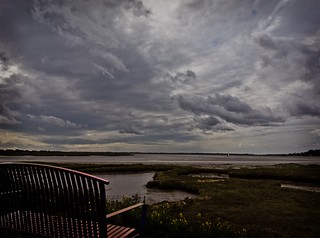
Clouds over the river Colne
SWC B1 W30_20110917_04_DxO_1024x768
Sep-11 • Ludovic Lemaignen on Flickr
book1 circular wivenhoe swcwalks walk30 6365836847

Clouds over the river Colne
SWC B1 W30_20110917_19_DxO_1024x768
Sep-11 • Ludovic Lemaignen on Flickr
book1 circular wivenhoe swcwalks walk30 6365837271
View of the river Colne
SWC B1 W30_20110917_23_DxO_1024x768
Sep-11 • Ludovic Lemaignen on Flickr
book1 circular wivenhoe swcwalks walk30 6365837659

Boats on the river Colne
SWC B1 W30_20110917_24_DxO_1024x768
Sep-11 • Ludovic Lemaignen on Flickr
book1 circular wivenhoe swcwalks walk30 6365838089

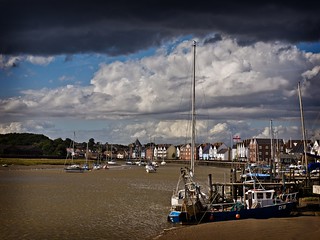
Wivenhoe harbour
SWC B1 W30_20110917_37_DxO_1024x768
Sep-11 • Ludovic Lemaignen on Flickr
book1 circular wivenhoe swcwalks walk30 6365838631
Wivenhoe harbour
SWC B1 W30_20110917_38_DxO_1024x768
Sep-11 • Ludovic Lemaignen on Flickr
book1 circular wivenhoe swcwalks walk30 6365839151
To Rowhedge by ferry across the River Colne
| Length | 14.8km (9.2 miles), 4 hours 15 minutes. For the whole outing, including trains, sights, meals and ferries, allow at least 9 hours 30 minutes. |
|---|---|
| Toughness | 2 out of 10 |
| OS Maps | Explorer 184 or Landranger 168. Wivenhoe, map reference TM 036 217, is in Essex, 5km south-east of Colchester. |
| Features |
This walk is made up of two loops, one on the Wivenhoe side of the river Colne and one on the Rowhedge side. However, there is no bridge - you need to take a ferry. This means the full walk is only possible at weekends and on Bank Holiday Mondays between Easter and the middle of October when the ferry at Wivenhoe is working (although you might be lucky enough to thumb a lift across from a boat at other times). You also need to get there at a time to suit the tides (see the travel details below). But it is well worth making the extra effort to fit in this unusual walk. Both parts of the walk are about 7km, so allow 2 hours for each. Wivenhoe, perhaps because of its proximity to the University of Essex, is a remarkable village bursting with community spirit, with volunteers out there constantly manning the ferry, re-roofing the boat house or washing down the slipways. There are always half a dozen dinghies being made by amateurs in the riverside’s Nottage Maritime Institute. From the church and town, the morning’s walk is along the mudflats of the River Colne past zones of former dereliction (now in the course of regeneration through new housing), past a £14.5 million flood surge barrier, and past sand-extraction works and lakes created in old extraction craters. Returning to Wivenhoe, catch the ferry over to the village of Rowhedge. Rowhedge must be the only village in the UK where swans frequently block the main high street. But having circumvented this fearsome obstacle, you go via the church into a wood controlled by the Ministry of Defence and used on occasions as a firing range. The last part of the return journey is, for some, the highlight of the day: passing the lovely Norman Church of St Andrew in Fingringhoe, with its chequerboard design of banded flint, to the former Fingringhoe Mill and on along the John Brunning Walk – mudflats and saltmarshes beside Roman River and a haven for heron, redshank, lapwing, shelduck, kestrels and barn owls. |
| Walk Options | Both in the morning and the afternoon, shorten the walk or retrace your steps as necessary to ensure that you do not miss the ferry. A short cut for the morning walk is given in the walk directions (see the asterisk [*] below). It is also possible to do just the first or just the second half of the walk. Buses from Head Street in Rowhedge leave for Colchester every 15 minutes or so. |
| History |
In the fifteenth century, the twelfth Earl of Oxford was Lord of the Manor at Wivenhoe. He and his comrade-in-arms Viscount Beaumont held out in the last castle to surrender to the Lancastrians. They were imprisoned for over a decade. Beaumont later went insane, was looked after by Oxford and died. Oxford then married Beaumont's young wife Elizabeth. The fine brasses to Elizabeth and Beaumont lie in the chancel of the parish church. In the 1750s there was a health spa at Wivenhoe, with fashionable folk taking seawater baths at a fee of one guinea for the season. An earthquake on April 22nd 1884 damaged over 200 buildings, with nearly two tons of brickwork crashing through the roof of Wivenhoe Hall. The Nottage Maritime Institute (tel 01206 823 029) in Wivenhoe was founded in 1896 by Captain Charles Nottage to 'improve navigation skills'. It has information on the area's maritime heritage, and welcomes visitors from 11am to 4.30pm daily from late April until mid-September (or by arrangement at other times). The flood surge barrier was completed in 1993 and is designed to resist the highest tide likely to be seen in a thousand years. Sluices ensure the tidal flow is unchanged except when the barrier is closed. The north wall of the Church of St Andrew at Fingringhoe dates from 1100. The church originally belonged to a French priory in Mersey and was dedicated to their St Ouen, who was Archbishop of Rouen. St Ouen has since been corrupted to St Andrew. Items hidden within the church at the time of the Reformation have recently been uncovered, including a Trinity crucifix. Fingringhoe Mill closed in the early 1990s. It was a tidal mill in the sixteenth century, with a wheel underneath, but was converted to steam in the 1800s. |
| Ferry |
The timing for this walk is complicated because of the need to fit in with the varying tide times on the River Colne. To work out the right train to catch, consult the timetable - then see the Travel section below. Wivenhoe to Rowhendge Ferry timetable : the ferry operates most (but not all) weekends from April to October for 3.5 hours around high tide when tide times permit. |
| Travel |
Catch the latest train from Liverpool Street Station to Wivenhoe that will arrive at least two hours before the official timetable start of the ferry operating period. This will allow you to do the Wivenhoe leg of the walk first before catching the ferry. However, if this would mean catching a train that leaves Liverpool Street before 8.45am, then catch the latest train that will get to Wivenhoe at least 5 minutes before the start of the ferry operating period and catch the ferry straightaway on arrival: do the Rowhedge leg first, on the far side of the river, and the Wivenhoe leg later. The ferry fare per passenger (2022) is £1.50 - cash only - from Wivenhoe to Rowhedge and £ 1.50 for the return; £ 2.00 each way for bicycles, dogs and children under 5 free. Bring cash for your fares. The fares do not cover the running costs of this volunteer run ferry, and so the Wivenhoe Fingringhoe Rowhedge Ferry Trust relies on donations to keep it going. For the past twenty years the SWC has sent a donation to the Trust on behalf of its walkers who enjoy this walk with a difference. Allow at least two hours for the Rowhedge leg and leave plenty of time to get back to the ferry before the last crossing back to Wivenhoe. If you miss the ferry back, you could catch a bus or a taxi into Colchester. Note that on some weekends there is no ferry service due to tide times so on these weekends it will not be possible to do the full walk. The train journey takes about 1 hour 9 minutes. |
| Lunch |
On the Wivenhoe side The suggested lunch place is the Rose & Crown pub (tel. 01206-826371) on The Quay, some 7.5 km into the walk, serving food midday to 2 pm daily, and from midday to 7 pm at weekends. Returning to the High Street (some 5 minutes from The Quay) the Greyhound pub (tel. 01206-825573) serves food from midday until 8 pm Monday to Saturday, and midday to 5 pm on Sunday. This pub has a good, varied menu (arguably better than the Rose & Crown's) and a pleasant large, part-covered rear garden. Other options: Italian and other restaurants in the High Street; a good cheap and cheerful chippy Tollgate Fisheries (tel. 01206-822018) three minutes from the Quay, and a very good, upmarket delicatessan The Wivenhoe Delicatessan (tel. 01206-822824), two minutes from The Quay, and perfect for picnic provisions, open Wednesday to Saturday from 9.30 am to 5 pm and on Sunday 10 am to 5 pm - closed Mondays and Tuesdays. On the Rowhedge side The suggested lunch place is The Anchor pub (tel. 01206-728382) on the High Street (80 metres from the ferry’s jetty), serving food from midday to 2 pm, and 6.15 pm to 9 pm, Monday to Saturday, and from midday to 8.30 pm on Sunday. This is a family friendly pub with good outdoor areas as well as indoor seating. Ye Olde Albion pub (tel. 01206-728972) at Rowhedge Quay does not serve food but welcomes walkers and allows them to eat sandwiches inside or outside – but do please buy a drink. This Free House is a watering hole for lovers of real ale and has won CAMRA pub of the year in earlier years. |
| Tea |
You have several options for tea back on the Wivenhoe side of the river: The Rose & Crown pub. The Greyhound pub The Black Buoy pub (tel. 01206-822425) on East Street. The Station pub (tel. 01206-822991) next to Wivenhoe railway station. The Nottage Maritime Institute sometimes serves tea and cakes in the afternoon, up to 5 pm. If you have time for tea on the Rowhedge side, your options are The Anchor pub or Ye Olde Albion pub. There is also a refreshment hut on the green by the ferry's jetty serving tea and coffee, soft drinks and a selection of home made cakes - ideal if you have a short wait for the arrival of the ferry to take you back across the river. |
| Updates |
No Major changes. [Pre 2011 editions]. The route through the new Cook's Shipyard housing developmemnt has been reinstated. Minor changes elsewhere, including the route through the new housing development just before you re-enter Rowhedge - this Edition and Book check August 2021 with minor additional updates May 2022. |
| Book |
This walk was originally published in Time Out Country Walks near London volume 1. We now recommend using this online version as the book is dated. The book contained 53 walks, 1 for every week of the year and 1 to spare. Here is our suggested schedule |
|---|---|
| Profile | |
| Help Us! |
After the walk, please leave a comment, it really helps. Thanks! You can also upload photos to the SWC Group on Flickr (upload your photos) and videos to Youtube. This walk's tags are: |
| By Train |
Out (not a train station) Back (not a train station) |
| By Car |
Start CO7 9DJ Map Directions |
| Amazon | |
| Help |
National Rail: 03457 48 49 50 • Traveline (bus times): 0871 200 22 33 (12p/min) • TFL (London) : 0343 222 1234 |
| Version |
Jul-22 Marcus |
| Copyright | © Saturday Walkers Club. All Rights Reserved. No commercial use. No copying. No derivatives. Free with attribution for one time non-commercial use only. www.walkingclub.org.uk/site/license.shtml |


Walk Directions
- [1] Coming off platform 2 at Wivenhoe Railway Station, do not go over the bridge but take the tarmac path on its left-hand side, your direction 115°. In 30 metres you pass the Station pub over on the other side of the railway tracks. 45 metres further on turn left, go up brick on edge steps to an earth access road, with King Georges Field opposite. Here you turn right, your direction 80°, and keep ahead, ignoring ways off.
- In 70 metres the road becomes tarmac and you keep ahead, passing a car park with public WCs on your left. In 60 metres, at the High Street T-junction, with the Greyhound pub opposite (a lunch and post-walk refreshment option) you turn right downhill. In 85 metres you pass on your left-hand side the entrance to St Mary’s Church (worth a vist). In a further 45 metres you pass on your left-hand side Wivenhoe Delicatessan , very good for picnic provisions, and in a further 5 minutes bend right with the main road for 10 metres, then left , to continue down to the banks of the River Colne.
- The Walk on the Wivenhoe side of the river
- Turn left, along The Quay, with the Royal British Legion Hall on your left.
- In 20 metres you pass the Nottage Maritime Institute on your left-hand side and in a further 10 metres the Rose & Crown pub, a lunch option on this side of the river.
- Continue straight on, along a gravel track next to the riverbank, in 50 metres going over a concrete ramp with a wooden (private)jetty on its right. The route ahead through the former Cook’s Shipyard, for a long time diverted whilst the residential redevelopment was in progress, has now been reinstated.
- Keep ahead on the gravel track which becomes The Folly after 30 metres. In 40 metres you enter the Cook's Shipyard Residential Development with its brick pavings. In 30 metres ignore a footpath post on your left, pass through bollards and keep ahead, in 25 metres coming out onto an estate road.
- Turn right and as the road swings to the left bear right to the head of Pearl Walk, with a public pontoon directly ahead. Bear left onto an asphalted access road and in 40 metres go through bollards to keep ahead. As the access road swings left, keep ahead (slightly right) to pass the Environment Agency’s River Colne Barrier Flood Control HQ then the barrier itself.
- Now take the pedestrian path ahead, which soon becomes a gravel path, alongside the bank of the river on your right. In 25 metres you pass the Wivenhoe Sailing Club on your left-hand side. A dismantled railway line runs parallel away on your left-hand side. You now walk on the gravel and stone surfaced sea wall path, in 50 metres going through a wooden swing gate.
- In 85 metres ignore steps down to your left with an iron pipe railing [A] (this is where the walk rejoins the sea wall path towards the end of the ‘Wivenhoe side’ leg of the walk – see below). In a further 50 metres, you pass the sand extraction workings on the other bank of the river.
- 280 metres past these workings, you go through a metal swing gate, some 10 metres past a wooden bench on your left, and continue on the sea wall path. In another 280 metres you pass a wrought iron metal bench on your left-hand side. In 270 metres, just as the path is entering trees, ignore a wooden kissing gate to the left [2].
- If you want a short cut back to town, take this path and in 400 metres you come to a lane T-junction where you go left – see the asterisk [*] below – rejoining the main walk.
- But continuing with the main walk: the path bears right and you continue ahead, now just within the right-hand edge of a wood, with treeline on your right and the river beyond, on an earthen path, ignoring ways off, and in 330 metres you cross a path with a footpath post on your left and continue onwards. In 140 metres you have a choice of either forking right on a path (between 8 inch wide lichen covered concrete gateposts), your direction 210°, back down to the riverbank, to continue for 200 metres by the riverbank before rejoining the ‘upper’ path, or just staying on the ‘upper’ path.
- If you have kept on the ‘upper’ path, continue ahead, ignoring ways off. The wood on your left ends and you now have a hedgerow on your left-hand side. In 500 metres, with the red-brick Alfresford Lodge (marked on the OS map) over to your left-hand side, fork left at a path junction through concrete posts, with a metal bench seat to your right, your direction 120°, to continue with a fence and field on your left-hand side. In 125 metres ignore a grassy way to your left (a wooden swing gate marked Private Property - No Trespassing).
- In 240 metres, you pass the remnants of a derelict pier on your right-hand side, with the last remnants of abandoned towers with pulleys which once carried overhead conveyors, in a line to your left.
- In 100 metres [3], with a wooden bench seat on your left, and an Alresford Creek information panel on your right, turn left through a gravel car parking area, your direction 50° and in 20 metres the gravel becomes a worn tarmac road. Keep ahead up this road, initially gently uphill, later more steadily uphill, ignoring ways off.
- In 170 metres you pass sand extraction works to your left-hand side, and then a giant sand extraction crater to your right (usually hidden from view from the road). 250 metres further uphill, you pass on your right-hand side the gated entrance to Plumpton Farm & Holiday Lodge. The road now levels out and just before it starts to go downhill (by a 30 MPH road sign) [!] take the signposted public bridleway left by a house called Broomlands, your direction 295°, initially down a private quarry access road - with a sign on a gate for Creek Lodge and Alresford Lodge.
- In 20 metres bear slightly left to go through bollards onto a grassy bridleway, with a mesh fence and bushes on your left, with the quarry road running parallel to you on your right behind a hedgerow. You now stay on this bridleway to the left of the quarry road until it exits onto a main road - but in more detail: in 240 metres pass through bollards and keep ahead over a gravel parking area.
- In 50 metres the quarry road swings to the right and you pass an entrance to the quarry works and lodges. Keep ahead, slightly right, in 20 metres passing an electricty pole with transformer on your left then through a propped open metal fieldgate onto a wide gravel path, your direction 300°. Keep ahead, in the same direction as a line of pylons some 30 metres over to your left in the open field, and with the quarry road still on your right.
- In 190 metres, where your track begins to have hedges on both sides, you can if you wish fork left into the field on your left to continue along its right-hand edge in the same direction, now with hedges on your right-hand side, to rejoin the track in 150 metres, but the recommendation is you just keep ahead on the track. In 150 metres [4] where the field-edge route rejoins from the left, keep ahead, your direction 335°.
- In 400 metres you pass to the right of a metal fieldgate, painted white, to pass the entrance to Alfresford Grange, on your left, at the head of its tarmac access road, with Grange Lodge to your left.
- Keep ahead on this tarmac access road through a woodland strip and in 200 metres ignore a private road to the left to Marsh Farm. In a further 270 metres, the access road joins the private quarry road at its entrance as both come out on to a main road (Wivenhoe Road) which you cross then turn left along its grassy verge, your direction 305°.
- The road swings to the right and after 110 metres [5], with the driveway of a house called The Chase on your right, [!] cross back over the road to go through a metal kissing gate, your direction 260°, on a path gently downhill which meanders through trees and bushes.
- In 280 metres go through another metal kissing gate and onwards, on an earthen path with bushes to your left and a wire fence to your right with a water meadow beyond. In 220 metres go up earthen steps to cross over the disused railway embankment, then go down the earthen steps on the other side, to pass through a metal kissing gate and onto a broad grassy path across a water meadow, heading back towards the riverbank.
- In 225 metres climb up steps with an iron pipe railing ([A], see above) and turn right back along the sea wall path. You now retrace your steps into town, to the Rose & Crown pub a possible lunch stop. The ferry is 25 metres beyond the pub
- The Walk on the Rowhedge Side of the river
- Take the ferry to Rowhedge. From its jetty turn left across a green to The Anchor pub, the suggested lunch place on this side of the river. Ye Olde Albion pub is another 100 metres further down the High Street.
- To continue the walk: opposite the Anchor pub, [!] turn uphill on Church Street. In 120 metres you bear left into the churchyard of the Church of St. Lawrence.
- In 45 metres you pass the church on your left-hand side (worth a look inside) and in 25 metres you exit the churchyard through the church gates on the other side, to continue along Church Hill. In 50 metres, at a road crossing, with house No.17 on your left-hand side, go left, due south, on Taylors Road.
- In 70 metres you come to a T-junction [6] where you go right on Parkfield Street. In 50 metres you go through a metal swing gate to the left of a pair of iron 1953 Commemorative Coronation Gates, on a signposted public footpath, straight on, with woodland to your left and a sports field and a line of trees on your right (each tree a poignant living memorial to those in the village who died in the First World War).
- In 200 metres exit the sports ground through two posts and enter a wood. Keep ahead, ignoring ways off, initially on a ridge path with woodland below to your left and right.
- In 60 metres, having swung left with the path, and having gone through a number of concrete posts on your either side, ignore a very steep minor path down to the left and bear right. In a further 70 metres, at the start of a wooden fence and houses to your right-hand side, ignore another very steep narrow path down to the left and concrete steps down to the right. Then in 35 metres, by a footpath post, ignore a path to the right and fork left , your initial direction 230°, with a close panel wooden fence on your right.
- In 75 metres you come to a road, with a public footpath signposted right but you go straight across, your direction 230°. In 12 metres you pass to either side of a concrete bollard in the middle of the path and bear left through woodland.
- In 65 metres by a footpath post fork right (where going left would lead to a burial ground in 35 metres), your direction 245°. There is a large and rather lovely lake down way below you off to your right-hand side.
- In 150 metres you come to a tarmac road [7] which you cross to pass through a wooden kissing gate and turn right for 15 metres and then swing left on a path through a Military Firing Range in Ministry of Defence land. Note : when the firing range is in use red flags are displayed and you should not proceed further into the woods. At all other times: keep ahead through the woodland following the public footpath sign, your direction 295° initially. In 30 metres the path bears left and in a further 70 metres ignore a signposted fork to the right and bear left on the main woodland path, your direction 240°. Keep ahead, ignoring ways off.
- In 220 metres you come to a path crossing by a triangular patch of grass where you [!] go straight on along a more minor, narrow path, by a footpath post, your direction 260° initially, downhill, soon swinging left then right.
- In 60 metres, at a glade, ignore the track to the right and carry straight on (slightly left). In 35 metres bear right with your main path, your direction 325°. Keeping straight on, in 50 metres you come to a car-wide earth track and path junction where you go left on this track, your direction 265°.
- In 30 metres at a T-junction bear left onto a car-wide track, your direction 230° with a post and wire fence on your left-hand side.
- Ignore all ways off to stay on the main track through woodland. In 100 metres ignore a stile on your left and in a further 40 metres ignore a track to the left, to keep straight on. In a further 400 metres, having ignored several ways off, ignore a grassy car-wide fork to the left to keep on your main track. In 145 metres you cross a path (by a sign warning of the Military Firing Range) to keep on the main track. In 200 metres you pass to the left of a heavy duty metal fieldgate, and in 10 metres you come out to a lay-by of the B1025 road [8], where you go left, in 25 metres joining this B road. Continue ahead along the left-hand grassy verge of the road and in 200 metres you cross a bridge over Roman River to go immediately left on Haye Lane.
- In 400 metres, towards the top of the hill, [9] with Woodside Cottages on your right, [!] turn left on a gravel car lane, signposted Byway, your direction 80°, in 30 metres passing the entrance to Haye Cottage on your right. Keep ahead on this car lane between hedges.
- In 320 metres you pass Haye Farm on your left-hand side and in a further 750 metres West House Farm and Old West House (both marked on the OS map).
- In 80 metres at a triangular green with a large oak tree in its middle and a village sign for Fingringhoe to one side, fork left, your direction 75°, coming to the main road [10] in 35 metres, where you go left, your direction 45°.
- In 25 metres you pick up a surfaced path parallel to (and to the right of) the road, to continue on, with treeline to your left and a wire mesh fence with recreational fields beyond on your right.
- In 150 metres you rejoin the main road to go onwards. In 120 metres you pass the Whalebone pub on your left-hand side, to keep straight on, passing on your left-hand side Fingringhoe Primary School then the Church of St Andrew’s, Fingringhoe, (well worth a visit).
- In 100 metres [!] take the signed public footpath to your left your direction 350°, which heads down the private drive of Mill House. You pass Roman River Mill and a new workshop and garage, with the river to your right, then on your left Roman River House, a converted mill, then The Mill, to cross over a new wooden bridge and onto a tarmac path, with a red brick wall to its left. In 25 metres follow the path to the right, down four earthen steps to join the John Brunning Walk, your direction north, through a water meadow on an earthen path between wire fences. Keep ahead on the path wirh meadows on either side.
- In 60 metres go over a wooden footbridge with two handrails, by Roman River. In 60 metres swing left with the path and in a further 50 metres, ignore the stile to the left (missing, August 2021) to keep right on the John Brunning Way, following its arrows and keeping beside the river, in a woodland strip.
- Ignore ways off. In 125 metres go down eight earthen steps, with a pipe handrail to your right, ignore a path to your left and keep ahead, slightly right, over wooden slats with a pipe handrail on your right. At the far end of the slats go up two earthen steps and in 10 metres you exit the woodland path. [!] Here you can either keep ahead on a path up and over the open field directly ahead of you, which in 240 metres rejoins the riverside route at point [11] or you can stay on the riverside route, as follows: turn right on a path back down to the river, your direction 120°, initially through woodland. In 40 metres at a fork take the right fork by a footpath post to exit the woodland - you are now back out in the open in a water meadow with saltmarshes and the Roman River over to your right. In about 100 metres go over a bridge with metal handrails. In 130 metres ignore a signposted fork to the left.
- In 70 metres [11] go up a new flight of six wooden steps with a metal pipe handrail and at the top turn right. You now walk on a surfaced footpath alongside a new housing development (on the site of what used to be a warehouse development). You pass a children's playground on your left then the new houses, with the river over to your right. The path bears to the left in a wide arc and after some 425 metres your onward path through the housing development continues over a broad promenade. At its end you turn left then in 30 metres turn right to enter a Rowhedge residential street.
- In 100 metres you pass Ye Olde Albion pub on your left as you make your way back to the ferry's jetty in Rowhedge. Take the ferry back to Wivenhoe.
- At the quay in Wivenhoe, if you wish to stop for tea, head for one of the recommended places, then make your way back to Wivenhoe Railway station, initially reversing your outward route back up the High Street, then turning left on Station Road, in 225 metres, passing The Station pub on your left-hand side, with Wivenhoe Railway Station on your right. The nearside platform is the one for trains back to London.