Borough Green to Sevenoaks walk
A Country House, Igtham Mote (NT), Knole Palace and deer park (NT), as well as pretty countryside, and close to London.


Borough Green to Sevenoaks
Apr-17 • Cymbidium Clarisse on Flickr
borough green sevenoaks kent countryside walk hike swcwalks book1 walk36 spring english british walkicon 33832099271

Plaxtol, Ightham Mote & Knole House
| Length |
16.1km (10 miles), 4 hours 30 minutes. For the whole outing, including trains, sights and meals, allow at least 8 hours 30 minutes. |
|---|---|
| Toughness |
4 out of 10 (more when muddy) |
| OS Maps |
Explorer 147 or Landranger 188. Borough Green, map reference TQ 608 573 is in Kent, 9km east of Sevenoaks. |
| Features |
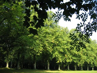
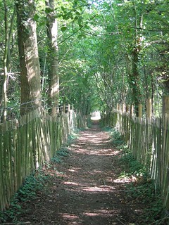
This lovely walk passes Ightham Mote and the dramatic and very large Knole Palace (both National Trust). The palace is set in a pretty deer park. The walk starts in Borough Green, and goes south through woods and along streams to the old village of Plaxtol with its Cromwellian church. Then through the park of Fairlawne House to Ightham Mote, a beautiful moated medieval manor, and lunch in its National Trust restaurant. The route onwards is up a bridleway, through orchards and alongside a new lavender farm and along shaded woodland paths leading to the 1,000-acre Knole Park and its 365-roomed Knole House, then up by footpaths to tea in Sevenoaks, with the station some way downhill from the centre. In winter many of the bridleways on this walk can be very muddy (particulary those from Basted to Plaxtol) so at such times do wear appropriate footwear. |
| Walk Options |
You could order a taxi from Plaxtol or from Ightham Mote. There are occasional buses from Plaxtol to Borough Green Station but not at weekends. Two short detours (both adding about 1.4km to the walk’s length) are described in case you would prefer to have lunch at a pub rather than the National Trust restaurant at Ightham Mote (which is not open every day: see below). |
| History |
The Cromwellian Plaxtol Parish Church, built in 1649, has a fine seventeenth-century hammer-beam roof that was originally painted blue. Thomas Stanley of Hamptons, later beheaded for his part in the execution of Charles I, contributed money for repairing the church. There is a slab in the nave floor recording the death, within one month in 1771, of four young children of the Knowles family. Knole House, built in the fifteenth century (and so huge that it has a room for every day of the year), was visited by Elizabeth I in 1573, who granted it to Thomas Sackville. It remained in the Sackville family and was the childhood home of Vita Sackville-West, featuring in Virginia Woolf's Orlando. The House, with its tapestries, paintings and collection of seventeenth-century furniture, is open to visitors from mid-March to the end of October, Tuesday to Sunday (plus bank holiday Mondays) from 11 am to 4 pm with last entry at 3.30 pm. The Brewhouse Cafe is usually open until 4.30 pm (no entry charge for non-members). Admission to the House is free to NT members. Otherwise (2023): £15.00 for House showrooms, Tower and grounds; £ 6.00 for Tower and grounds. Pre-booking on-line is preferred for all NT members and visitors. The house stands in a park of 1,000 acres. There is no charge for walking in the park and in any case the route described in the walk directions follows public rights of way. Ightham Mote (pronounced 'item') is a lovely Tudor and medieval moated manor house and garden (tel 01732 810 378); Although the building can be seen clearly from the public way it is well worth a full visit. It is open 11am to 5pm from March to October, with shorter, more restricted opening times in winter. In November visits to the House are by tour only. Entry is free to NT members. Otherwise, admission (2023) costs £16.00. Pre-booking is no longer required although it is recommended at busy times. There is no entry charge for visitors who just wish to take lunch or tea in the NT cafeteria. |
| Travel |
Take the train nearest to 10am from Victoria Station to Borough Green & Wrotham. Journey time 40-45 minutes. There are frequent trains back from Sevenoaks. Journey time 35 minutes to Charing Cross, or about an hour to Victoria. Borough Green and Sevenoaks are on different lines but a day return to Borough Green is usually accepted for the return journey from Sevenoaks. |
| Lunch |
The suggested lunch place is the National Trust restaurant at Ightham Mote, some 6.9 km into the wealk, which is open at the same times as the house and additional weekends as well so worth checking; you do not need to pay the entrance fee to use the restaurant. If you prefer a pub lunch or for times when Ightham Mote is closed, between Plaxtol and Ightham Mote you could divert to the Chaser Inn in Shipbourne (tel 01732 811 168), some 6.6 km into the walk, a large and elegant pub which serves inventive food all day. Directions to this pub are given in the main text. After Ightham Mote you used to be able to divert to the Padwell Arms, Stone Street but this pub closed as a pub some years ago: likewise The Snail, a pub-restaurant in Snail Street, as noted in earlier editions of the TO Book, closed down in September 2017. |
| Tea |
The newly refurbished Brewhouse Tearoom (tel 01732 450 608) has an entrance in the north wall of Knole House, without the need to pay an entrance fee. During British Summer Time this pleasant tearoom is open unto 5 pm with last orders 4.30 pm and serves cream teas. In winter the tearoom closes earlier. There are various options in the centre of Sevenoaks including Caffè Nero at 112 High Street (tel 01732 779 050) and Costa Coffee at 2 Blighs Rd (01732 462 159). There is also a branch of the popular Bills on the High Street. Close to Sevenoaks Station is another possibility, Alpinia Patisserie at 1 Tubs Hill Parade (tel 01732 454 669) open till 6 pm Monday to Saturday. Within the main foyer of Sevenoaks Station are two coffee / tea franchises, handy for a takeaway drink on your journey home. |
| Updates |
No major changes, just minor updates. Entrance fee charges updated. This edition following book check December 2022. |
| Book |
This walk was originally published in Time Out Country Walks near London volume 1. We now recommend using this online version as the book is dated. The book contained 53 walks, 1 for every week of the year and 1 to spare. Here is our suggested schedule |
|---|---|
| Profile | |
| Help Us! |
After the walk, please leave a comment, it really helps. Thanks! You can also upload photos to the SWC Group on Flickr (upload your photos) and videos to Youtube. This walk's tags are: |
| By Train |
Out (not a train station) Back (not a train station) |
| By Car |
Start TN15 8BG Map Directions Return to the start: Finish TN13 1DP Map Directions Travel to the start: |
| Amazon | |
| Help |
National Rail: 03457 48 49 50 • Traveline (bus times): 0871 200 22 33 (12p/min) • TFL (London) : 0343 222 1234 |
| Version |
Mar-23 Marcus |
| Copyright | © Saturday Walkers Club. All Rights Reserved. No commercial use. No copying. No derivatives. Free with attribution for one time non-commercial use only. www.walkingclub.org.uk/site/license.shtml |


Walk Directions
- [1] Turn right uphill (eastwards) out of Borough Green Railway Station to a T-junction (Wrotham Road), with a Sainsbury's Local opposite (useful for picnic provisions). Cross the road at the pedestrian lights and turn right to go over the railway bridge, your direction 205° initially.
- In 70 metres the road swings to the right to become Western Road but you keep ahead along the pavement, soon passing the driveway to the village hall and public toilets on your left. In 150 metres cross over the A25 (there is a signalled pedestrian crossing to your left) and carry straight on now on Quarry Hill Road, your direction 220°.
- [2] In 50 metres, opposite the Church of the Good Shepherd on your right-hand side, [!] turn left into The Landway, following the public footpath sign onto a tarmac car road, downhill, your direction due south.
- In 175 metres you come to a car road and cross it to continue straight on along a public footpath, now a path between fences, initially gently downhill but soon going gently uphill. In 280 metres cross a private drive to Reynolds Retreat and carry straight on between chesnut pailing fences, now in light woodland. In 275 metres the path bends left, going steeply downhill for 160 metres, with woodland on either side, to cross a stream on a wooden bridge with wooden handrails.
- [3] 80 metres further on you come up onto a car road. Go on this road, leftwards (due south initially) with a wide grassy bank (a picnic area) on your left, then in 200 metres the start of a lake, also on your left. In 150 metres the lake ends on your left and you enter the small, picturesque village of Basted with modern detached houses on your left, and the pavement starts. A stream is down below you on your left. After 220 metres the pavement ends but go straight on (along Basted Mill), ignoring the Mill Lane right turn opposite. Instead, continue on past a grassy area hehind a hedge and then Bridge House on your left; in another 20 metres [!]bear right on to Mill Lane at the junction with Plough Hill, following the restricted byway sign, onto a car-wide track, your direction 205° [4].
- Pass Orchard Cottage on your right with the stream on your left. In a further 80 metres you pass Basted Cottage on your right. Another 130 metres brings you past Woodruff Cottage, also on your right, after which the track narrows and becomes a potentially muddy path, with woodland to left and right, and the stream still on your left-hand side.
- In 350 metres, as the path swings gently to the left, ignore the stile and metal swing gate on your right, with a tiny stream behind it and to its left.
- In 325 metres ignore a fork left (which crosses the stream on a concrete slab bridge) and in a further 45 metres you come to a T-junction with a car road where you go right uphill, your direction 275° [5].
- In 115 metres, once over the steepest part of the hill [!] turn left over a stile in the hedgerow, with a concrete public footpath marker, your direction due south, to go through an apple orchard.
- In 150 metres, at the end of the orchard, continue ahead. In 30 metres, at the corner of the field, you enter a wood downhill, your direction 140°. In 25 metres cross a stream and a wooden bridge with wooden rails, then go over a stile and up the other side to emerge from the wood in 50 metres.
- Go ahead on the enclosed path, gently uphill, your direction 220°. You then continue in more or less the same direction for 1.3km till you come to the church in Plaxtol.
- But in more detail: After 180 metres go through a gap to the left of a wooden fieldgate and pass a bungalow on your right, to continue steadily uphill on what is now a track with hedges on either side. In 270 metres ignore the stile on your right into an apple orchard and keep ahead, still steadily uphill. In a further 330 metres, as the track swings to the right, ignore a minor, unmarked footpath to the left, and continue ahead , now gently uphill. To your left behind a low hedge is a horse paddock, with a new wooden stable block, and to your right, behind a high hedge, is a large apple orchard. In 200 metres the track joins from the right a tarmac car road [6]. Continue in the same direction, due south initially. In 50 metres pass an oasthouse with three conicle roofs on your right. In another 100 metres ignore a car road to the left called Grange Hill to continue on your road, now called Tree Lane. After a further 150 metres you come to a road T-junction with a stone war memorial directly ahead of you and Plaxtol Church on the right, well worth a visit [7].
- Here turn right up Church Hill, also known as Plaxtol Lane, your direction due west. 300 metres up this hill and with the strange, disused, isolated gateways of Fairlawne Estate 150 metres off to your left, turn left over a stile in a gap in the estate's stone wall with a wooden fieldgate to its left, onto a signposted footpath, your direction 170°.
- Continue on a faint path (a grassy way) down the grassy field to pass to the left of the fenced coppice in front of the large gateways (NOT the smaller fenced coppice some 40 metres to its right). Once past the (larger) coppice, drop down a slight bank and bear right to head gently downhill, your direction 215° aiming towards a yellow post. In 100 metres you reach this post. Now continue ahead, very slightly left, across the grassy field towards another yellow post beside a stile in a wooden fenceline. In 180 metres cross this stile in the fenceline and keep ahead, passing 3 metres to the left of an oak tree on a grassy way. You now have a good view of the impressive Fairlawne House over to your right.
- [8] In 100 metres you come to anothe yellow post marking a path crossing in the grassy field. [!] You now have a choice : to continue to Ightham Mote on the main route, or detour to Shipbourne and the Chaser Inn.
- To continue on the main route:[!] at the path crossing in the grass turn right , westwards. Follow the path as it curves right down the field and in 200 metres go through a wooden swing gate. Turn right down a tarmac lane towards a pond and buildings but in 20 metres turn left on a tarmac lane away from the houses, your direction 205° with a garden on your left-hand side.
- In 70 metres by the wooden bridge on your left, turn right uphill on a tarmac lane, your direction 290 degrees. In 130 metres exit by a wooden swing gate (a wooden fieldgate to its left) and cross the A227 with care to keep straight on, along the earth and gravel road opposite, your direction 290°.
- In 150 metres at a cross paths turn right on a car-wide earth road, your direction 15° and 20 metres further on go through a wooden swing gate (a pair of wooden fieldgates to its right) into a field where you continue straight on along its left-hand edge. In 150 metres turn left through a wooden fieldgate to go on a narrow bridleway between hedges, initially downhill, your direction 280°.
- In 575 metres you come to a tarmac road and the entrance on your right to Ightham Mote, the suggested lunch stop (but see the note on opening hours in the introduction). Follow the signs to the restaurant.
- After lunch, return to the entrance and turn right up the lane, your direction 250°, passing alongside the Manor. Follow the lane as it turns left away from the house. 60 metres beyond this bend go out through its brick-pillared gateway and turn right onto a road.
- Continue from point [8a] below.
- To detour to Shipbourne: at the path crossing in the grassy field keep straight ahead as you aim for another yellow post. In 125 metres you come to this post and now bear left towards the corner of the open space. When you get there pass through a gate. Ignore a tarmac drive to the left shortly after this, but take the tarmac drive half-left,your direction 160°and pass a pond on your right-hand side.
- In 80 metres, when you are level with the end of the pond and some buildings on the right, keep straight on to a wooden swing gate to the left of a wooden fieldgate. Continue down the left-hand edge of a grassy field, and at its far end, in a field corner with trees, cross a footbridge with a metal handrail, then head up across an arable field.
- In 145 metres at the top of the field ignore a path along its top edge to your right, but instead go straight on along a narrow path between hedges. This leads out onto an access road, where you keep ahead to emerge onto the large village green of Shipbourne. Turn right down the length of the green to reach the Chaser Inn, immediately to the left of the church, in about 500 metres.
- After lunch, go up the track to enter the churchyard throuigh its lychgate. Fork right around the church on a sandy gravel path and leave the churchyard at the far end through a kissing gate, by a three-arm footpath sign. [!] Immediately after this gate, turn right over a stile, part hidden in the hedge, ignoring a path straight on and to the left.
- Keep to the right-hand edge of the green space beyond, heading downhill between newly planted trees. In 150 metres, in the far corner of the green space, cross a pair of stiles some 10 metres apart and carry on between fences.
- In 250 metres cross a stile in the far corner of the field and veer left across a track to carry on up a broad grassy strip on the left-hand edge of a field, with a wire fence to your right, your direction 300°. Ignore a private path slanting left in 50 metres to keep on along the line of trees.
- In 150 metres more, at a field corner marked by a yellow post, veer right uphill with the fence towards a stile into the woods, also marked with a yellow post. In 80 metres cross this stile and carry on up a fenced path into the woods. This takes you up over the hill and down the other side.
- In 300 metres leave the woods via a stile and turn right along a newly fenced-in footpath. In 80 metres go through a gap in the boundary and turn left into the next field and go up its left-hand edge. In 120 metres cross a stile and keep uphill on a road. In 100 metres you come to the brick-pillared gateway to Ightham Mote on your right.
- The walk route continues along the road, but the view of the house across the moat merits a look: fork right into its driveway, which in 60 metres brings you to the moat in front of the house. If you want to stop for refreshments, the National Trust restaurant is further round to the right, beyond the shop. Afterwards, retrace your steps to the gateway and turn right onto the road.
- [8A] Both routes continue: Go along the road for 450 metres, your initial direction 300 degrees, soon passing Mote Farm on your left and then a row of cottages on your right. [!] Just before an isolated cottage on your right-hand side, turn left on a signposted track, a potentially muddy public bridleway, your direction 285 degrees.
- [9] In 120 metres, as the track swings to the left you pass Hoppers Huts on your left (Do stop and read the information panel about them). Keep ahead, gently uphill, now through light woodland. In 480 metres, with a wooden barrier ahead and a pond to the left, ignore the permissive path next to the barrier and turn right following a Greensand Way blue arrow up a what becomes a steep and potentially muddy, slippery woodland path, your direction 330 degrees; as you go uphill a way can be found parallel to the bridleway, a metre or so above it to the right which may be slightly less muddy.
- After following the narrow path through an intermittently wooded area for 250 metres you exit the woodland to come out into the open, to continue ahead, your direction 350°, on a wide track passing to the left of an apple orchard. You then have lavender fields to your left and right - colourful in June-July, as you continue ahead, ignoring all ways off. In 300 metres the track becomes a surfaced track and in a further 400 metres you come out on to a car road junction. Cross both roads to a gap opposite with a metal fieldgate on its left.
- Take the path that leads diagonally across a field, between a line of young apple trees on either side, your direction due west. In 220 metres, at the corner of the field, go through a gap in the tree line which marks the field boundary and continue ahead on a narrow path next to a field with a fence to the left and tree line to your right. In 150 metres you pass through a barrier and cross a car road [10].
- Go straight on along an earth and gravel car road signposted as a public bridleway, your direction 280°, past Lords Spring Farm Cottage on your right and in another 100 metres past Lord’s Spring Oast, also on your right. You are now in a woodland strip, initially heading gently downhill. Now keep ahead as your way dips in and out of woodland, at times with fields to left and right.
- About 1km along this track, which in places narrows to a path, you come to two small houses on your right and you carry straight on, going along the earth driveway of these houses. In 90 metres at a track junction ignore the turning to the left (which has a concrete public footpath marker) but in a further 50 metres, opposite some wooden stables, [!] take the footpath left into the wood (it too has a concrete public footpath marker), your direction 220° [11].
- Go more or less straight on for the next 500 metres. In more detail: In 160 metres cross a path by a post with yellow arrows. In a further 185 metres cross another path, also by a post with yellow arrows. Now continue straight on, with a black chainlink fencing on your right. In 180 metres you come out on a tarmac driveway and follow this for 50 metres to a car road.
- Turn right on this car road, your direction 345° and in 100 metres turn left on a signposted public footpath into Sevenoaks Preparatory School , your direction 260°.
- Cross the school's tarmac car park and keep ahead between the school's grass playing fields. You pass between two seating arrangements (around an old oak tree stump to your right and a young oak tree to your left). Now keep ahead down the next grass pitches until you come to the end of the pitches and the tree line in the boundary directly ahead. Here turn right and make for the right-hand corner of field and the new wooden swing gate to the right of a new wooden fieldgate. In 80 metres pass through the swing gate to come out onto a narrow tarmac road. Here you turn left, your direction 210°, to go gently downhill, through woodland. [12].
- In 200 metres you exit the woodland and pass two houses on your left, to then bear right with the road and when the tarmac ends you continue on a path uphill. In a further 100 metres you enter Knole Park through a metal deer protection gate to the left of a heavy duty access gate.
- You have two paths forking ahead of you; take the wider one to the right, your direction 265° (not the path to the extreme right). In 75 metres fork left between two large trees (the right-hand one being an English oak), your direction 245°. There is immediately a swathe of grassland on your left.
- In 85 metres, having passed a fallen tree on your right, you come to a tiny pond (winter only) on your left and then the remnants of a large dead tree trunk on your right. Keep straight on, your direction still 245°. You can just see the garden wall of Knole House at 260° by the top of the far hill. Note your onwards path that leads steeply downhill from you, then uphill towards the house.
- 175 metres down from the tree trunk cross a wide avenue and continue up the other side on the wide grass path, going due west. 200 metres up from the avenue pass through a cluster of ten oak trees.
- In a further 85 metres cross a tarmac path to continue straight on, despite a ‘Danger - Golf Course’ sign on your right. In 90 metres you cross a fairway (beware golf balls coming from the right). After a further 50 metres, you see Knole House’s garden walls on your left. Carry on along these walls. You pass the entry to the Brewhouse Tearoom. At the end of the walls turn left for the Knole House entrance if you want to go inside.
- To continue the walk from the end of the high wall go straight ahead, continuing on the alignment of the wall, over grass and through the car parking area, heading uphill on no clear path towards a clump of trees at the top of the hill, your direction 315°. On your way up you will probably need to weave your way round parked cars. Once there, you come to a footpath post whose direction you follow over grass, and soon gently downhill, on a bearing of 310°. In 150 metres, having passed another footpath post, you pass a crater depression on your right and keep ahead, downhill, now on a clear, sandy path that leads to a tarmac drive. Cross it, go down three earthen steps and keep straight on, downhill on a sandy path, your direction 300° [13].
- In 200 metres you come down to a grassy valley bottom which you cross over to leave Knole Park by a metal deer protection gate to go steeply uphill, your direction 265°. In 5 metres ignore the path to your right.
- In a further 200 metres keep to the tarmac path as you pass on your right a new chalet housing development (on the site of a former leisure centre) and then a new multi-storey car park. Keep ahead on the path now with a stone wall on your right and railings above a brick wall on your left, coming out onto the forecourt of a Waitrose supermarket, with the store on your left. Here turn right then first left to head down Akehurst Lane, a passage between building with a brick paviour floor, your direction 255 degrees. This leads out to Sevenoaks High Street.
- There are various possibilities for tea in Sevenoaks. For Caffè Nero turn right down the High Street. For Costa Coffee, cross the High Street, turn right and continue to Blighs Road on your left.
- After tea you will need to get to London Road which runs west of (50 metres behind) the High Street for the station. From Costa Coffee cross the car park to the far side where steps lead down to London Road; then turn right downhill. From Caffè Nero carry on along the High Street to the traffic light junction where you turn left along Pembroke Road; when you reach London Road, turn right.
- Continue for 800 metres (600 from Pembroke Road) down London Road to reach Sevenoaks Railway Station on the left.