Hanborough to Charlbury walk
Blenheim Palace, its beautiful landscaped parkland, a Roman road, and flint stone villages.

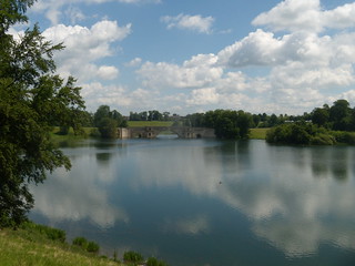
Blenheim Park
The long drive behind the Column of Victory. Hanborough to Charlbury
swcwalks book1 walk38 blenheim walkicon banner 4661257430

Not as daft as it looks
Stock (or is it people? ) are controlled using temporary electric fences. The gates stay put. Blenheim Palace. Hanborough to Charlbury
swcwalks book1 walk38 walkicon 3503059221


Poppies
Jun-14 • Sarah Heenan on Flickr
book1 walkicon swcwalks walk38 hanboroughtocharlbury 14194160249
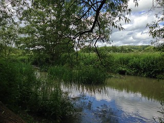
The Evenlode
Jun-14 • Sarah Heenan on Flickr
book1 walkicon swcwalks walk38 hanboroughtocharlbury 14400976963
Blenheim Palace & Cornbury Park
| Length | 22.1km (13.7 miles), 6 hours. For the whole outing, including trains, sights and meals, allow at least 11 hours. |
|---|---|
| Toughness | 5 out of 10. |
| OS Maps | Explorer 180 or Landranger 164. Hanborough, map reference SP 433 142, is in Oxfordshire, 7km north-west of Oxford. |
| Features |
This is a lovely walk, just an hour and a quarter's journey by train from London into Oxfordshire's countryside and the extensive grounds of Blenheim palace. The River Evenlode and its soft, easy hills and fertile countryside inspired Tolkien’s Hobbit Shire. The start of the walk is good for blackberries in September. Before lunch, there are the 2,100 acres of the Great Park leading to Blenheim Palace, its lake and the Column of Victory that the first Duke of Marlborough had placed on the horizon so that he could see it from his bedroom. Once over the wall out of the Park, the route is along Akeman Street, the Old Roman road from Alchester to Cirencester, with big stone slabs from the old road still visible in places. This is now part of the Oxfordshire Way and the leg of over a mile to Stonesfield is through open farmland and progress can be hard work if into the wind. At lunchtime you could picnic in the meadow by the Stonesfield Ford and the old slate quarries, or picnic in the heart of the village (the only remaining pub in the village closed in 2020 and remains closed as of March 2023). You pass through the delightful stone villages of Stonesfield, Finstock and finally Charlbury, entering it from a footpath beside Lord Rotherwick’s deer park, Cornbury Park. Charlbury has many nice pubs. |
| Walk Options |
At point [7] in the Directions, you can turn right to go directly into Stonesfield for your picnic lunch, without going down to the riverbank. This reduces the length of the walk by a mile. After lunch, there is a very pretty shortcut straight along the Oxfordshire Way into Charlbury (see the double asterisk [**] in the Directions). This reduces the length of the walk by another 2 miles. Alternatively, you could take an infrequent bus from Stonesfield to Charlbury or Oxford, or phone for a taxi. This walk also works well when done "backwards" - that is, in reverse, from Charlbury to Hanborough, with an early lunch stop at the Plough Inn, in Finstock. Walk Directions for the walk in reverse are at the end of the Main Directions. |
| History |
The Royal Estate of Woodstock was granted to the first Duke of Marlborough in 1704. The old medieval palace had been the birthplace of the Black Prince in 1330 and Elizabeth 1 was imprisoned there during Queen Mary’s reign. It was extensively damaged by the Parliamentary army in the Civil War. Blenheim Palace was built for the first Duke in recognition of his victory over the French at the Battle of Blenheim in 1704 and the Column of Victory has some 6,000 words engraved on it in honour of the Duke. Designed by Vanbrugh, the Palace is a fine example of English Baroque, set in parkland landscaped by Lancelot "Capability" Brown. The Park is the home of the greatest collection of ancient oak trees in Europe, with a number of 900 year old oaks in the High Park section of the Park. The Palace was the birthplace of Sir Winston Churchill in 1874, and there is a permanent exhibition of Churchilliana in the Palace, plus a new Churchill Exhibition (2021). Within the Palace complex and grounds are a number of cafes and formal restaurants for those making a day of their visit. The Palace and Formal Gardens are open to the public daily from 9.30 am to 4.30 pm from early April to November, and from November to April on Wednesday to Sunday. The Park is open from 9 am to 5 pm or dusk if earlier. Tickets for entry must be purchased in advance (on the day on line is fine). Entry costs (2023) to the Palace, Park and Gardens: £ 35.00: to Park and Formal Garden: £ 22.50. Family tickets and concessions also available. Your ticket, although initially expensive, lasts for a year (as an annual pass) so you can get excellent value from it by making return visits. The walk through the Park is on public footpaths or permissive paths and there are no admission charges if you keep to the walk's directions. For further information, and for information on what’s on, phone 08700-602080. The village of Stonesfield is the home of Stonesfield slates, the stone roof tiles that are characteristic of villages and towns in Oxfordshire and many of the Oxford Colleges. The slates are no longer mined, so only second-hand tiles can be obtained at great expense. Cornbury Park is a private estate whose deer park was carved out of the Wychwood Forest (as was Blenheim). Wychwood Forest was once a vast royal hunting ground that extended over much of western Oxfordshire; in pre-Norman times it extended all the way to London. Now the sole surviving remnant of the forest lies within Cornbury Park estate. The imposing seventeenth-century mansion was built for Edward Hyde who was Viscount Cornbury and the first Earl of Clarendon. As one of Charles II’s chief advisors and Lord Chancellor he became the virtual head of the Government in 1660. |
| Travel | Take the train nearest to 9am from Paddington Station to Hanborough. Journey time about 1 hour 15 minutes. Trains back from Charlbury are hourly. Journey time about 1 hour 20 minutes. Buy a day return to Charlbury. |
| Lunch |
For non-picnickers, lunch on this walk continues to be problematic. What was the Black Head in Stonesfield is long gone. The one remaining pub in this village, The White Horse, some 13.5 km into the walk, has had a very chequered history of opening then failing. As of May 2023 the pub remains closed. A new owner puchased the property in 2021, despite efforts by the "Back the White Horse" Community Group to purchase the pub and run it as a community pub. The intentions of the new owner are not known and the fabric of the pub is deteriorating during the present hiatus. There is a modicum of good news (March 2022) as the Parish Council has re-listed the property as an "Asset of Community Value" so any attempt by the owner to redevelop the property as housing is unlikely to succeed. An alternative, late lunch stop - if you can make it in time - or if you are doing this walk "backwards" - is the Plough Inn in Finsock tel 01993-868333, some 10 miles into the walk, via a short detour from the main walk route. If doing the walk in reverse, the pub is some 3 miles from Charlbury. This 18th century thatched village pub serves home cooked meals from 12 noon to 3 pm, Tuesday to Friday (closed Mondays) and from 12 noon to 11 pm on Saturday and from 12 noon until 6 pm on Sundays. |
| Tea |
At walk end the Bell Hotel (tel 01608-810278) on Church Street, Charlbury, makes for a comfortable and pleasant tea stop. Please note: this pub-hotel is temporarily CLOSED Spring 2023 having been purchased by new owners who are making some internal alterations before reopening in autumn 2023. There are also three pubs in Charlbury awaiting your custom: The Bull Inn (tel 01608 81068900), good for food; Ye Olde Three Horseshoes (formerly known as The Farmers), both on Sheep Street, and the Rose & Crown (tel 01608 810103), with its good choice of beers, on Market Street. If doing the walk in reverse, you have two pubs in Hanborough which you should find open for refreshments. |
| Updates |
This edition October 2019. No major route changes. Detour to the Plough Inn, Finstock, and some minor updates added March 2017. Directions for the walk in reverse walk added October 2019. Pub updates August 2023. |
| Book |
This walk was originally published in Time Out Country Walks near London volume 1. We now recommend using this online version as the book is dated. The book contained 53 walks, 1 for every week of the year and 1 to spare. Here is our suggested schedule |
|---|---|
| Profile | |
| Help Us! |
After the walk, please leave a comment, it really helps. Thanks! You can also upload photos to the SWC Group on Flickr (upload your photos) and videos to Youtube. This walk's tags are: |
| By Train |
Out (not a train station) Back (not a train station) |
| By Car |
Start OX29 8LA Map Directions Return to the start: Finish OX7 3HH Map Directions Travel to the start: |
| Amazon | |
| Help |
National Rail: 03457 48 49 50 • Traveline (bus times): 0871 200 22 33 (12p/min) • TFL (London) : 0343 222 1234 |
| Version |
Aug-23 Marcus |
| Copyright | © Saturday Walkers Club. All Rights Reserved. No commercial use. No copying. No derivatives. Free with attribution for one time non-commercial use only. www.walkingclub.org.uk/site/license.shtml |


Walk Directions
Main walk
- [1] Coming out of Hanborough Railway Station, walk the 85 metres up the access road to the A4095, dead ahead. Cross over the road by the pedestrian traffic lights and turn left along the pavement. Down in the valley on your right-hand side you can just make out the River Glyme. In 140 metres you cross over a bridge over the railway line. Continue along the road, uphill, towards the village of Hanborough.
- In 300 metres you pass a large stone cottage (No 153) on your right-hand side. 100 metres beyond that, you come to a turning on your right-hand side (Park Lane), which is a dead end [2].
- Turn right into Park Lane, gently downhill. In 200 metres, you come to the end of the houses. Continue straight on along the path ahead, indicated by a bridleway sign, your direction initially 325°, with a stone wall on your right-hand side.
- In 20 metres you pass on your left the entrance to High Thatch. Over the wall, ahead on your right-hand side, you can see the tower of Combe Church.
- In 100 metres the path brings you out into a field and you follow it along its right-hand edge, with a hedge on your right, going downhill in the same direction as you were just previously.
- In 150 metres, on approaching a wide gap in the hedge ahead, turn right through a narrow gap in the hedge to your right and immediately turn left along the left-hand edge of that field, still downhill, with the hedge now on your left.
- In 300 metres you come to the far corner of this field, with a metal fieldgate on your left-hand side. Turn left through the gap to the left of the fieldgate (where there used to be a wooden swing gate) to go down the car-wide track with a stone wall on your left-hand side, your direction 250°. The River Evenlode runs alongside the track, down below on your right-hand side.
- In 115 metres you come up to a road, at a bend in the road. Turn right along this road, in 15 metres crossing the river on a stone bridge. In a further 115 metres you pass the entrance to Blenheim Estate Sawmills and Combe Mill on your left-hand side.
- In 90 metres pass under the railway bridge and keep straight on, steadily uphill, ignoring ways off and with Combe Church visible on the horizon ahead on your left-hand side. In 450 metres you come to the top of the hill, where there is a house on your right behing a stone boundary wall.
- In a further 200 metres (and 25 metres after Boltons Farmhouse on your right-hand side), there are footpath signs pointing off to the left and right. [3] Turn right off the road, over a stile, following the footpath sign (‘East End half a mile’), your direction 85° initially, along a grassy path.
- In 200 metres you come to the far left-hand corner of the field. Cross over the stile in the hedge and turn right, walking along the right-hand side of the next field, with the hedge on your right, towards a house in the distance, your direction 110° initially.
- In 300 metres you come to the far side of the field. Cross a stile in the hedge ahead and continue straight across the next field, to cross a stile 40 metres away, next to a stone building. Turn left up the drive for 35 metres to the road.
- Turn left along the road. In 225 metres you come to the Combe Gate entrance to the Blenheim Estate. Turn right, following the footpath sign through the high wooden kissing gate to the left of the main gate, to go straight ahead up the estate road. In 50 metres you come to a T-junction and turn left. Follow the road as it bends around to the right and down the hill through the trees. The road then swings left then right.
- In 350 metres you come to a clearing; if you stop just before the treeline and look to the right, you may just be able to see the top of Blenheim Palace through the trees. The road now swings to the left then right downhill, through some conifers.
- 300 metres further on, you come [4] to the edge of the trees on the right-hand side, where the road ahead goes around to the left, downhill. Straight ahead on the hillside opposite are half a dozen copper beeches in two clusters. On your right-hand side there is a Blenheim Palace black and white public footpath sign and a new bench seat. [!] Turn off the road here and walk around the tree line on your right, your direction 55°, following the clear grassy path, gently downhill, which swings to the right. Depending on the time of year, there may be an electric cattle fence on your left-hand side.
- In 200 metres you come down near to the edge of the lake – with ‘Private – No Public Access’ signs directly ahead and over to your right. Bear left with the path to go through a wooden swing gate. Now bear right onto a track. Keep ahead, soon with the start of the Lake on your right-hand side, your direction 70° initially. In 70 metres you come to a junction in the track, with a broad grassy way going uphill on your left. Ignore the grassy way and follow the wide track around to the right, along the side of the lake, gently uphill.
- In 600 metres the path curves sharply to the left and up a rise. From this point, you have a fine view over to your right across the lake to the Great Bridge and your first real view of Blenheim Palace, a view that will slowly unfold as you continue along this path, around the lake towards the bridge.
- Keep to this path for the next 600 metres, mostly gently uphill, ignoring ways off down to your right to the lake, until the path brings you down to a wooden swing gate at a T-junction with a tarmac drive. Turn right down the drive and in 85 metres, at a junction in the drive, turn left for 5 metres then left through a wooden swing gate in the electric cattle fence on your left-hand side.
- Note: there is a right of way to the start of the Great Bridge for views to the left and right across the lake, but if you want to visit Blenheim Palace, which is highly recommended, you will need to buy a ticket in advance (or on the day over the internet is fine). Continue ahead down the drive to cross over the Great Bridge and keep ahead for the Palace.
- But to continue the walk: having gone through the swing gate, head across the grass, gently uphill, towards the Column of Victory, your direction 325°. In 500 metres, at the Column, pass it and continue ahead across the grass in the same direction as before and in 60 metres cross the wooden fencing ahead at a part lowered for walkers.
- [!] The suggested way ahead may not be an official public footpath, but it is well used and appears to be permitted by the Blenheim Estate. [!] The original Book's route - on public footpaths - has you turning right at the Column and over grass to the estate road, where you turn left . However, the permitted route, as follows, is more pleasant: Keep ahead across the grass, your direction 325°, keeping parallel to the wooden field fence 150 metres over to your left. In 400 metres the path across the grass comes down to a tarmac estate road, coming in from your right. There is a public footpath down this estate road.
- Now continue along this estate road or the grassy areas to the left or right for 300 metres, in the same direction as before, then bear left across the grass to the corner of the wooden fence over to your left.
- On reaching the fence corner, continue along the fenceline with the fence on your left-hand side. In 60 metres [!] you turn left over the stile in the fence, marked with a black Blenheim Park footpath disc. [5].
- Continue ahead beside the wooden fence on your left-hand side, your direction 210°. In 250 metres you come to a copse of trees surrounded by a wooden fence. Turn right and follow the fence around the trees in a circle.
- After walking around the circle of the fence for some 75 metres [!] you head a quarter right across the field, aiming for the wooden kissing gate in the fence ahead of you, with a copse of copper beech trees ahead, slightly left, on the far side of this fence, your direction 220°. The Shakespeare's Way joins from across the field.
- In 110 metres go through this wooden kissing gate and follow the direction indicated by the Blenheim Park footpath disc. You are now aiming for a gate in the wooden fence on the far side of this field, to the right of a second clump of copper beech trees in the middle of the field, your direction 320°.
- In 130 metres you pass the clump of trees on your left-hand side and in a further 200 metres you go through the wooden kissing gate in the fence ahead. You now bear half-left across a paddock for 30 metres to go through another wooden kissing gate, coming out on to a car-wide track, with a double wooden fieldgate opposite, a little to the left. Turn right along this track which leads through a band of trees at a field boundary.
- In 40 metres on the far side [!] turn sharp left, in the direction of the Blenheim Park disc on a fence post, along a car-wide track, your direction 235°, with a hedge and tree line on your left and an open field to your right. The track (muddy in winter) curves a little to the right.
- [!]In 150 metres, as the track swings to the left, you come to a post on your left-hand side marked with multiple Blenheim Park footpath discs. Here turn right and in 10 metres pass through a wooden swing gate, keeping ahead beside a wooden fence on your left-hand side, your direction 305°, between large fields.
- In 400 metres go through the wooden swing gate ahead of you, marked with Blenheim Park footpath discs. 15 metres ahead at the edge of the wood is a footpath post with a yellow arrow. Follow the direction of the arrow along a narrow path between the edge of the wood on your left and the electric cattle fence on your right.
- In 60 metres [!] you turn left through the trees on an unmarked but clear path into the wooded area: in a further 40 metres follow a yellow footpath arrow on a wooden bridge with wooden railings to cross over this bridge. 20 metres further on, you come to a stony car-wide track. Turn right, your direction 350°, though the wood.
- In 200 metres you come to another track at a crosstracks, with an Oxfordshire Way disc on a post on your left-hand side. Turn left on to a footpath and in 20 metres go up wooden ladder steps over a high stone wall [6], and leave the Great Park down the ladder steps on the far side, going into the large field beyond.
- Walk straight ahead with a very ancient hedgerow (at least 500 years old) on your left-hand side, your direction 260° along a path that was once the Roman Akeman Street, with a vast field on your right.
- You are now on the Oxfordshire Way which you will follow straight ahead for the next 2 km. But in more detail:
- In 500 metres you go straight over a road and continue along the footpath on the opposite side, still with the hedgerow on your left-hand side. Soon you can see the rooftops of the village of Stonesfield, the suggested stopping place for lunch. In about 800 metres the path switches to the other side of the hedgerow and you continue ahead, now with the hedge on your right-hand side.
- In 700 metres you come to another road [7].
- If you do not intend to picnic beside the River Evenlode, you can take a direct route to the village of Stonesfield by turning right along this road (Combe Road), steadily uphill. In 475 metres you come to a T-junction with Woodstock Road by Stonesfield’s War Memorial. Here turn left and another in 100 metres turn right into Pond Hill. Continue the directions at the asterisk [*] in paragraph 43 below.
- To head for the River Evenlode: cross over the road and continue straight on, keeping a hedge and valley on your left (Bagg's Bottom on the OS map), your initial direction 240°. At the end of the first field, pass through the field boundary with a stone wall on your right and turn right, then immediately left to continue ahead, still following the hedge and valley on your left, in the same direction as before, but now with a vast field on your right.
- Continue along the Oxfordshire Way, ignoring all ways off, for a distance of 650 metres from Combe Road, and then go through a metal kissing gate to the Stonesfield Ford meadows by old stone quarries, to swing right on a wide grassy path down to the River Evenlode. In 100 metres go through a metal kissing gate and turn right – where to go left takes you over the Evenlode footbridge. (30 metres further along the river, on this side and right of the footbridge, is a good spot to swim. This whole area is good for a picnic).
- Having turned right, your onward path into Stonesfield is relatively steeply upwards, away from Stonesfield Ford, initially in a cutting, your direction 10°. Go up some steps in the path and after 200 metres up this path go through concrete bollards. In a further 25 metres pass on your left-hand side an Oxfordshire Geology Trust notice about Stonesfield’s fossils and slates. Here the Oxfordshire Way branches off to the left on a grassy path, but your route is directly ahead. The path soon levels out and becomes a track (Brook Lane) between hedges, as you come into the outskirts of Stonesfield.
- In 200 metres you come to a churchyard on your left-hand side. The track is now a surfaced road (Church Street). Keep ahead and in a further 175 metres the road swings to the right at the junction with High Street on your left.
- In 75 metres you come to a T-junction where you continue more or less straight on, slightly to the left, along Pond Hill.
- [*] Continue down Pond Hill and ignore all roads off to the left and right. You soon pass on your right-hand side ‘Best One’ Convenience Store, a possible stop for basic picnic provisions. Some 400 metres along Pond Hill from the junction with Church Street, you come to a T-junction with the Ridings. Opposite, slightly to your right, is the White Horse pub, currently CLOSED (August 2023).
- At the T-junction turn left, downhill, following the sign to Fawler and Charlbury. In 160 metres ignore the Boot Street fork, uphill to the left, and 125 metres further on down the hill, you pass a 1722 house called Clockcase on your right-hand side. 30 metres further on [!] turn right off the road up a car-wide track, rejoining the Oxfordshire Way, with its sign, your direction 330° initially. Note the traditional slates on the building on your right-hand side at the start of the track and looking back, on other buildings in the village.
- In 300 metres you come to the top of the hill next to a barn (Highfield Farm). 100 metres further on you come to a cross tracks where you can look back for a panoramic view of the village of Stonesfield. Take the tarmac lane going straight ahead, on the Oxfordshire Way, heading in the same direction as before, initially with a hedge on your left and open fields to your right. Once over the brow of the hill you have open fields on both sides of you.
- In 500 metres you come to a telegraph pole and a building on the right-hand side, where the lane curves sharply around to the right.[!] Turn left off the track onto another track, in 15 metres passing Hill Barn Switchgear Station on your right (hidden in undergrowth in summer). Here [!] turn right through the undergrowth and in 10 metres go through the wooden swing gate, next to a fieldgate, with a faded Oxfordshire Way disc on it. Continue straight ahead, downhill, along the left-hand edge of the field, following a hedge and fenceline, your direction 290° initially.
- In 150 metres you come to the bottom, left-hand corner of the field. Go through the gap left by a missing wooden gate and turn right up the car-wide track, following the sign for the Oxfordshire Way. The track heads down into a dip then up the other side, before levelling out, with a hedge on your left and open fields to your right.
- After 750 metres along this track you come to a cross roads, opposite a clump of trees [8] where the Oxfordshire Way goes straight ahead through the trees.
- [**] To take the short cut continue straight on at this point, along the Oxfordshire Way, all the way into Charlbury, your initial direction west. Your are on a narrow, clear path with hedges and trees on either side which in places widen to woodland strips. Beyond on either side are vast fields. In summer the trees form a canopy overhead which provides good shade on a sunny day. Keep ahead along the mostly level, woodland path, in a westerly direction, ignoring all ways off. In 1.45 km the path comes out on to the access drive of a house called Pippins, on your right-hand side. In 5 metres turn left down a gravel access road (Stonefield Lane) which in 100 metres joins a main road at a bend in the road. You now keep ahead along the road into Charlbury, and follow the instructions below for getting to the suggested tea stop or to the railway station via the churchyard.
- The main route is to turn left onto the car-wide track going into a field on your left, with a footpath post with multiple blue arrows on your right. Walk along the right-hand edge of the field, initially with a hedgerow and later a stone wall on your right-hand side, your direction 220°. Ahead, on the hillside opposite, you can see the village of Finstock, which is on the route of the walk (and further to the right, on the horizon, the Wychwood Forest).
- In 900 metres you come to a T-junction with the main road (do not turn right and head for Finstock station – as there are no trains at weekends and only one a day in each direction on weekdays). Instead, turn left at this T-junction to go down the hill into Fawler village. In 70 metres you pass Manor Barn, a restored farm building, on your right-hand side.
- 200 metres further on, you pass a red postbox mouned on a garden fence on your right-hand side. 40 metres beyond the postbox, after the road has gone uphill, and opposite a bus stop, turn right down a tarmac lane, going past Corner Cottage on your left-hand side, your direction 160°.
- In 100 metres at the end of the tarmac keep ahead, slightly right, and in 80 metres go over a stile to the right of a wooden swing gate (often padlocked). Cross the field ahead towards the ironstone railway bridge and in 65 metres you go over a stile or through the wooden swing gate to its right, to go under the archway beneath the railway. 10 metres beyond the archway, turn left and cross the footbridge over the River Evenlode. On its far side, turn right along the riverbank, your direction 245°; (in summer the first 75 metres of this path are often overgrown).
- After 150 metres along the riverbank, go through a metal kissing gate. 15 metres further on, follow the path as it bends left, away from the river, your direction 240°. In 35 metres you come out into the open.
- Walk along the bottom of the valley on a grassy way and in 250 metres you come up a gentle incline to go through a metal gate. 8 metres further on you come up to a meeting of paths, with a footpath post ahead. Turn left for 5 metres and then at a T-junction turn right on to a valley path going gently uphill, in the same direction you were going in before (245°), between hedges and barbed wire fences. The path can be muddy in winter.
- After 400 metres along this rutted path with an uneven footbed (unpleasant to walk along), you pass under an electricity line, and 8 metres beyond you pass a metal fieldgate on your right-hand side. In a further 50 metres or so, you come to a footpath post with a blue disc ahead, slightly right, and hidden in undergrowth, [9].
- At this point your detour to the Plough Inn, Finstock starts, for a late lunch or early tea stop. For the pub stay on the rutted path for a further 380 metres and the path becomes a restricted byway - Dark Lane. At the top of the lane you join a village road (The Bottom). Turn right and in 30 metres you come to the pub on your left-hand side. Leaving the pub, cross the minor roads ahead and walk up the road ahead. In 80 metres you come to a main road (Well Hill ) where you turn right . Keep ahead on this road, which soon goes uphill and bends to the left. You pass a Primary School on your left-hand side, and the road becomes School Road. Continue ahead until you pass Wards Lane, a minor cul-de-sac on your right, where the Main route joins.
- To follow the main walk route at point [9] you turn right up a path, steeply uphill, with a post and wire fence on your right and a hedgerow to your left, your direction 315°. In 70 metres, at the top of the incline, keep ahead , slightly left, along a narrow path between hedgerows (unless this path is overgrown, in which case walk along the left-hand edge of the field to your right), with a vast field beyond, your direction 300°.
- In 140 metres, as the path swings to the right, you come up to a white farmgate on your left-hand side. Pass through a gap to its left and follow the path around to the left as it becomes a car-wide track (Wards Lane), with allotments on your left and properties on your right, heading into the village of Finstock, your direction 255°.
- In 50 metres you pass a cottage on your right called Madeleine. 200 metres further on, you come to a T-junction with the main street going through the village. Turn right into School Road. In 130 metres you pass a bus stop, a Parish Council and Village Notice Board and the Village Shop and Post Office on your right-hand side.
- In another 60 metres you pass the village war memorial on your right-hand side and come out to a T-junction with the B4022 road. On the opposite side of the road is Manor House. Turn right, following the sign for Charlbury and Chipping Norton.
- 50 metres down this busy and sometimes dangerous road [!] turn left over the unusual stone stile, marked by a footpath sign ‘To Charlbury’. Go through the hedge archway beyond, across to the far right-hand corner of the lawn. Go through the leftmost of the two fieldgates ahead, to walk straight down the track ahead, your direction 315°, ignoring all ways off.
- Note the huge array of solar panels covering the lower part of the opposite valley slope. In 650 metres you come out to a car-wide track with a stone wall to the right. Here bear right, your direction 30°.
- In 60 metres you cross a main track coming in from the left and head across the grass to a footpath post with a yellow arrow, your direction due north. In 60 metres you pass the post to keep ahead and in 75 metres you go straight on down the avenue of trees ahead of you, your direction 350°. [!] Do not go down the other avenue over to your left [!].
- Head down the avenue of trees and in 420 metres you keep ahead across grass when the avenue ends to then bear right on to a tarmac road [10]. Turn left on this road, opposite Southill Business Park, along the side of a trout lake, your direction 340°.
- In 115 metres you come to a green coloured metal gate into Cornbury Park . Go through the green coloured metal swing gate on its right, marked ‘Footpath gate’. Keep ahead, uphill along the path, your direction 350° and in 80 metres bear left to go through a metal kissing gate.
- Now follow the footpath ahead going between a high metal railing (deer protection fence) on your left and a lightly wooded area on your right.
- In 400 metres the wooded area on your right-hand side ends and you go through a metal kissing gate, to keep ahead along the path, still beside the high metal railing on your left-hand side, in the same direction as before. Deer can sometimes be seen in the park on your left-hand side. On your right-hand side, as you walk along, you will see the village of Charlbury.
- In 325 metres you come to the end of the path, where your exit has been diverted around a lodge building. The diverted route swings to the right then left and you leave the Park via a metal swing gate, then a gap in the wall, to come out onto the entrance drive to Cornbury Park. To your left you have a view of the house. Turn right down the drive, towards the village, your direction 40°.
- In 90 metres you cross a stone bridge over the River Evenlode, way below. 150 metres further on, the drive crosses over the railway line. On the left you can see the tower of Charlbury Church. 100 metres further on, you come up on to the road. Cross over to the pavement on the far side and turn left towards the village, your direction 330°.
- In 550 metres you come up past St Mary the Virgin Church, Charlbury, where the road curves sharply round to the right. You can take a short cut through the churchyard down to the railway station, or (for tea) turn right up Church Street.
- In 80 metres you come to the suggested tea place, the Bell Hotel, on your right-hand side (despite its name, in reality more of an inn (but note CLOSED Spring 2023, due to reopen under new ownership autumn 2023).The Rose and Crown (good for its choice of beer) and the Bull Inn (good for food) are a little further up the road at the main junction, and Ye Olde Three Horeshoes to the right at the junction on Sheep Street. To get to the railway station after tea at the Bell, coming out of the Hotel, retrace your steps to the churchyard, enter the churchyard and follow the tarmac path around the back of the church to the right. Follow the path straight out the other side of the churchyard, through a metal swing gate, past the Old Rectory on your left-hand side and down the road ahead. In 140 metres you come to a T-junction with the main road. Turn left down the hill towards the railway station.
- In 130 metres the road crosses over the river. 85 metres further on, at a mini-roundabout, turn left on to the station approach road, coming to the station in 100 metres. The nearside platform (platform 2) is for trains back to London. Charlbury Railway Station is a listed building designed by Isambard Kingdom Brunel.
Walk in Reverse: Charlbury to Hanborough
| Length |
With diversion to the Plough Inn, Finstock: 21 km (13 miles) |
|---|---|
| Toughness |
5 out of 10 |
| Travel |
If you plan to stop for lunch early in the walk, at the Plough Inn, Finstock, take a train nearest to 10 am from Paddington to Charlbury. For lunch in Stonesfield, take a train nearest to 9 am. If you wish to visit Blenheim Palace, take the earliest train possible - and not later than 8 am. |
| Lunch |
Some 3 miles into the walk you come to the Plough Inn in Finstock (tel 01993 868333). This 18th century thatched pub serves lunch from 12 noon until 3 pm, Tuesday to Friday: from 12 noon until 11 pm Saturday and from 12 noon until 6 pm on Sunday (pub closed on Mondays). |
| Tea |
There are two very acceptable pubs in Hanborough for refreshments at walk-end. Turning right on entering Hanborough, you come to the Three Horseshoes at 18 Main Road. Turning left on Main Road, as you head towards the railway station, you come to The George and Dragon at 133 Main Road. As your post lunch leg of the walk is long (10 miles), if you stopped in Finstock, you may also wish to stop in Stonesfield for refreshments at the White Horse pub (if open) or - and more likely - the convenience store in the village. |
- Coming off platform 1 at Charlbury Railway Station , follow the exit sign up the access ramp to cross over the railway tracks, then go down the stairs and bear right and head towards the station building. Here turn left up the station approach road, your direction east. In 100 metres at the mini-roundabout junction with the main road, turn right . In 85 metres you cross over the River Evenlode . The road now heads uphill and in 130 metres [!] turn right up Church Lane towards the church of St Mary the Virgin, Charlbury .
- Follow this narrow road gently uphill, passing cottages on your left-hand side and The Old Rectory on your right. In 140 metres at the top of the road bear left to pass through the iron gates to the church, now on a surfaced path. You pass the church on your left-hand side as the path swings to the left. Some 100 metres from the entrance to the churchyard you exit it through iron gates to come out onto a bend in the road. Turn right down the road (Park Street), which soon swings to the left.
- In 220 metres at the bottom of the hill, the road levels out and you keep ahead, slightly left, to pass Charlbury Pre-School on your left. In a further 330 metres, follow the footpath sign to turn right on to a surfaced estate drive, with signage to Cornbury Park Estate . In 100 metres you cross the railway line below on a stone bridge. In a further 150 metres you cross the River Evenlode on a longer stone bridge, and keep ahead, gently uphill.
- In 50 metres, just before you pass through stone pillars to the Manor House to Cornbury Park, with formal iron entrance gates some 45 metres beyond the pillars [!] turn left on a signed path adjacent to a stone wall. In 15 metres go through a metal swing gate and follow the path, soon around to the right. You pass a lodge building over to your right as the path swings to the left. You now keep ahead alongside a high metal deer protection fence on your right to Cornbury Park and with open fields beyond the fence on your left.
- In 325 metres go through a metal swing gate and you have the start of a light woodland strip on your left. In a further 400 metres go through a metal kissing gate and keep ahead (slightly right) for 80 metres down to exit the Park though the green coloured metal swing gate to the left of a metal gate and cattle grid, to come out on to a surfaced estate road.
- Keep ahead on this tarmac road and in 20 metres you come to a trout lake on your right. Cross the lake on a long stone bridge, and just beyond the end of the bridge, with the entrance to Southill Business Park on your left-hand side [10] [!] turn right off the road and bear left to head up an avenue of trees on a grassy way, your initial direction 185°.
- In 420 metres at the top of the avenue, keep ahead across grass. In 75 metres you come to a footpath marker post with a yellow arrow on your left-hand side. At this post bear slightly left across the grass and in 60 metres you come to a car-wide earthen track junction, with a low stone wall some 40 metres behind it to your left. Here bear half-right and take the track ahead, soon with a field edge on your right.
- Keep ahead on this winding track with treeline and hedgerow on your right, and a low mesh fence to your left with open fields beyond it. Ignore all ways off. In 325 metres the track narrows to a path, and the treeline on your right ends. You now bear right away from the fence on your left and the path drops down and swings left between fields, with an open field to your right. Keep ahead, gently uphill, your direction now 140°. Some 300 metres from the end of the treeline on your right go through a wooden fieldgate in a field boundary, with a stone barn (part dilapidated) on your right.
- Cross the lawn ahead of you, slightly to the right, and at its far side go through a hedge archway and cross an unusual stone stile to come out onto a road – the B4022. Turn right – taking care as the road can be busy – and in 50 metres turn left onto School Road.
- You pass on your left-hand side the village War Memorial, then what used to be the Crown pub, now a private house. Next you pass the village shop and post office on your left-hand side. Some 190 metres from the junction with the B road, the reverse of the Main Directions would have you turning left down a side road (Wards Lane) to continue the reverse of the main walk. But for lunch in Finstock, you continue ahead along School Road, in 130 metres passing Finstock Church of England Primary School on your right-hand side.
- School Road now becomes Well Hill as the road drops down and swings to the right. Some 210 metres beyond the school you come down to a minor road junction on your left. Turn left down the minor road for 80 metres to a T-junction with The Bottom and the High Street. Directly ahead of you is The Plough Inn , your pub lunch stop. Coming out of the pub, turn right along the Bottom and in 30 metres [!] turn left onto a restricted byway – Dark Lane. The by-way starts as a car-wide concrete track but in 120 metres it narrows to an earthen path, wide in places.
- Keep ahead along this path, part in a cutting, and in some 380 metres you pass on your left the turning uphill for the main walk [9]. Continue ahead along this path which has now narrowed between hedges and barbed wire fences, and now with an uneven footbed. This path can be muddy in winter. Continue along this unpleasant, rutted path, for another 400 metres, until you come to a bend in the path as it swings to the right at a path junction, with a footpath post and metal gate some 8 metres ahead of you. Go through this gate and keep ahead along the bottom of a valley on a grassy way.
- In 250 metres you enter light woodland through an arch in the hedgerow ahead of you, close to the river. In a further 35 metres your way bends to the right towards the river. In 15 metres pass through a metal kissing gate and follow the path beside the riverbank. This path can be overgrown in summer and muddy in winter.
- In 150 metres turn left and cross the footbridge to the left of the railway bridge over the River Evenlode. On its far side keep ahead for 10 metres to go under a railway archway and then go through a wooden swing gate (or cross the stile to its right). Now cross over a grassy field.
- In 65 metres go over a stile to the left of a wooden swing gate (often padlocked). Now keep ahead, slightly left, up a drive which in 80 metres becomes tarmac and swings to the left. Head uphill for a further 100 metres, with Corner Cottage on your right-hand side, to a road junction, where you turn left , down Main Road, with a bus stop opposite. You are now in the small village of Fawler.
- In 40 metres you pass a red post box on your left-hand side, mounted on a garden fence. In a further 200 metres, as the road heads uphill, you pass Manor Barn, a restored farm building, on your left-hand side. Keep ahead, still uphill, and in 70 metres [!] turn right onto a signposted car-wide track, initially concrete, to pass cottages on your left-hand side. The track soon becomes earthen, with hedges on either side as it heads uphill between large agricultural fields.
- In 600 metres the hedgerows on both sides end and on your left you now have a low stone wall – part dilapidated – and an open field on your right. Keep ahead now on a broad grassy way and in 300 metres go through a field boundary to a cross paths with the Oxfordshire Way [8]. Here [!] turn right on to the Oxfordshire Way , a broad grassy path with a hedgerow on your right, your direction 115°.
- Keep ahead on this broad grassy way along the right-hand edge of an open field, with a hedgerow on your right. In 750 metres, close to the bottom of the second dip in the way and just before the way swings sharply to the left [!] turn left through a gap to the right of a missing wooden gate. Now keep ahead, steadily uphill, along the right-hand edge of a field with a hedge on your right and an open field to your left.
- In 150 metres go through a wooden swing gate to the right of a wooden fieldgate and head up through undergrowth for 10 metres, then turn left to pass Hill Barn Switchgear Station on your left (hidden in undergrowth in the summer). In 15 metres you come out onto a tarmac lane near a bend in the road. Turn right on this lane – The Oxfordshire Way – for 500 metres, initially through a woodland strip then soon with open fields on either side and later with a hedgerow on your right.
- Go over a cross tracks and continue ahead, now downhill, with a hedge on your left. In 100 metres you pass a barn (Highfield Farm) on your left-hand side. Continue down towards the village of Stonesfield , now on a car-wide track, with a fine view of the village below with its classic Cotswold stone buildings with slated roofs. In 300 metres you come down to a road where you turn left . Head up this road into the centre of the village, in 30 metres passing a 1722 house called Clockcase on your left-hand side.
- In 125 metres ignore the Boot Street fork in the road up to your right, and keep ahead, steadily uphill, now on The Ridings. In 160 metres, having just passed Stonesfield Garage on your left, you come to a T-junction, where you turn right following a sign to Combe and Woodstock on a road called Pond Hill. Just beyond this junction and to your left is the CLOSED White Horse pub and restaurant.
- Continue uphill along Pond Hill, ignoring turnings to the left and right, to pass Best One Convenience store on your left-hand side. Some 400 metres along Pond Hill from the T-junction, you come to a road junction, with Church Street on your right and Woodstock Road on your left. Turn left into Woodstock Road for 100 metres before turning right beside Stonesfield’s War Memorial into Combe Road.
- Head down Combe Road for 475 metres until at a dip in the road the Oxfordshire Way crosses the road [7] on either side. Here turn left off the road onto the signed Oxfordshire Way, through a woodland strip to come out into the open with a hedge on your left-hand side and a vast agricultural field on your right. In 700 metres at a field boundary you switch sides of the hedge to continue ahead on this straight path, now with the hedgerow on your right, on a way between vast fields.
- In 800 metres you cross a minor road and continue ahead on the Oxfordshire Way, with the ancient hedgerow on your right and a vast field to your left. In a further 500 metres you come to the high stone wall [6] of Blenheim Great Park . Climb up the ladder stile over the wall and go down the other side, where you keep ahead for 20 metres through light woodland to a crosstracks, with an Oxfordshire Way disc on a post to your right.
- Turn right onto a car-wide, stony woodland track. In 200 metres turn left and in 20 metres cross a wooden bridge with wooden handrails. Keep ahead in woodland for a further 40 metres, where you turn right onto a path between the edge of the wood and on your right and an electric cattle fence on your left.
- In 60 metres at the edge of the wood you come to a footpath post with a yellow arrow on your right-hand side (which may be hidden in undergrowth in the summer). In a further 15 metres turn left through a wooden swing gate. Now keep ahead on a path between vast fields, with a wooden fence on your right, your initial direction 125°. In 400 metres pass through a wooden swing gate and keep ahead for 10 metres to a T-junction with a track, with a post with multiple Blenheim Park footpath discs on your left-hand side.
- Turn left onto the car-wide earthen track, with a hedge and treeline on your right and an open field to your left. The track curves to your left and in 150 metres at a track junction, turn right to go through a narrow band of trees in a field boundary. At the end of the band of trees and some 40 metres from the track junction turn left through a wooden kissing gate into a paddock, with a metal fieldgate 5 metres to your right.
- Bear half-right across the paddock and in 20 metres go through another wooden kissing gate, in a fence. Now bear half-right over a grassy field, your direction 140°, aiming for a clump of copper beech trees ahead of you, in the middle of the field. In 200 metres you pass to the left of these trees and in a further 130 metres go through a wooden kissing gate in a fence, with a second copse of copper beech trees to your right.
- Bear half left over the next field, aiming for the left-hand edge of a circular copse of trees surrounded by a wooden fence. In 110 metres you come to the wooden fence, where you bear right , to follow the fence as it bends around the copse. In 75 metres you come to the boundary fence in the field. Here turn left away from the copse, along the field-edge and alongside the wooden fence on your right-hand side, your direction 30°.
- In 250 metres at a fence T-junction cross over a stile in the wooden fence [5] and turn right to follow a grassy path beside the wooden fence on your right. In 60 metres the fence bears half-right and in a further 300 metres, you come to a wooden fieldgate in the fenceline on your right. Here turn left over the parkland grass, your direction 70°.In 70 metres you pass through an avenue of trees and in a further 30 metres you come to a tarmac estate road.
- Turn right along this road for the short distance of 25 metres, where it swings sharply to the left. At this bend leave the road and keep ahead on a permissive path over the parkland grass, uphill, aiming for the Column of Victory directly ahead of you. In 400 metres you come to fences surrounding the Column. Cross over them (a section has been lowered for walkers) and keep ahead over the parkland grass, gently downhill. You soon have fine views ahead of Blenheim Palace and the Great Bridge .
- In 500 metres you come down to a wooden swing gate in an electric cattle fence, directly in front of you. If you wish to visit Blenheim Palace keep ahead, cross the Great Bridge and make for the visitors’ entrance (highly recommended – but you will need to have taken a train from London at least 2 hours earlier to justify the entrance fee). Otherwise, go through this gate and turn right for 5 metres to a junction in the estate road. Turn right on the estate road and in 85 metres turn left through a wooden swing gate to go down a hilly path with a large lake down below to your left.
- Ignoring all ways off down on your left to the lake, keep ahead down this path which soon widens to an earthen track. In 600 metres the path curves sharply to the right, and you continue along this path as you head down towards the lakeside. In a further 600 metres you come to a junction in the track, with a broad grassy way heading uphill to your right. Ignore this grassy way and keep ahead.
- In 70 metres, as the lake on your left ends, bear left to pass through a wooden swing gate. Turn right to continue gently uphill on a clear grassy path, which soon swings to the left. In 200 metres you come up to a tarmac estate road [4] which you join by turning left . Now follow this estate road, steadily uphill, as it swings to the left and then right, three times. In some 650 metres you turn right to leave the Blenheim Estate in 50 metres by going through the Combe Gate exit (taking the high wooden kissing gate to the right of the main gate).
- Coming out onto a public road, turn left . In 225 metres [!] turn right down the drive of a farmhouse. In 35 metres turn right over a stile, next to a stone building. Keep ahead over a field for 40 metres to cross a stile in a hedge. Now keep ahead along the left-hand edge of the next field, with a hedgerow on your left. In 300 metres [!] cross another stile in a hedge and turn left .
- Keep ahead along the left-hand edge of a grassy field, following a mesh fence on your left-hand side. At the end of the fence keep ahead down the middle of an open, grassy field, and head for the far side of the field. Some 200 metres from the start of this path, go over the stile in the boundary to come out onto a public road [3] where you turn left , to head down the road (Boltons Lane). In 25 metres you pass Boltons Farmhouse on your left-hand side. In a further 200 metres, at the top of the hill,there is a house on your left-hand side behind a stone wall.
- In 450 metres you pass under a railway bridge. In a further 90 metres you pass on your right-hand side the entrance to Blenheim Estate Sawmills and Combe Mill. In a further 115 metres you cross the River Evenlode on a stone bridge. 15 metres beyond the bridge the road swings sharply to the right. [!] Here, directly ahead of you, is a footpath sign for a path which heads over fields to Hanborough. Cross a metal pipe stile and follow a clear path over an initially flat, open field, your initial direction 175°. The field can be muddy when not in crop.
- In 400 metres cross a stile in a field boundary and bear left with the path, now steadily uphill. In a further 200 metres at the top of the field, pass through a metal squeeze stile and walk through a passage between houses to come out onto a road (the A4095) in the centre of the village of Hanborough . For tea at the Three Horseshoes pub , turn right along the road. Otherwise, turn left down the road. In 610 metres, having passed the George and Dragon pub on your left-hand side, you pass Park Lane on your left-hand side (where the route for the main directions goes) [2].
- In 400 metres you cross over a bridge over the railway line. In a further 140 metres cross over the road by the pedestrian traffic lights and turn right down the access road for 85 metres to reach Hanborough Railway Station [1].