Princes Risborough to Great Missenden walk
Hilly. The Chilterns, and Bryant's Bottom

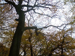
Monkton Wood beeches
Princes Risborough to Great Missenden walk
Nov-16 • Saturdaywalker on Flickr
swcwalks book1 walk 45 walkicon 30938485581
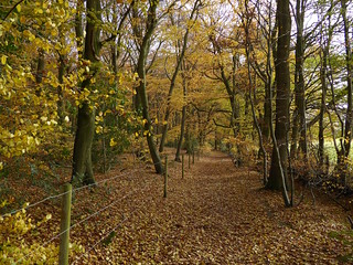
Monkton Wood beeches
Princes Risborough to Great Missenden walk
Nov-16 • Saturdaywalker on Flickr
swcwalks book1 walk 45 walkicon 30910337202

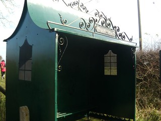
Lacey Green Golden Jubilee Bus-shelter
Not quite as pretty as the windmill. Turn left here. Princes Risborough to Great Missenden walk. In the Chilterns, SE England
book1 swcwalks walk45 3016828070


The Chilterns, a windmill & Bryant's Bottom
| Length |
15.7km (9.8 miles), 4 hours 30 minutes. For the whole outing, including trains, sights and meals, allow 8 hours. |
|---|---|
| Toughness |
6 out of 10 (7 when muddy). |
| OS Maps |
Explorers 172 & 181 or Landranger 165. Princes Risborough, map reference SP 799 027, is in Buckinghamshire, 11km south of Aylesbury. |
| Features |
This walk across the Chilterns – the walker’s heaven – is through sloping fields and beech woods and hamlets, past upmarket farms and upgraded cottages. The walk is not difficult but it does have two short, steep hills (with fine views) near the lunch stop which account for the toughness rating, although the walk directions do offer an alternative route which avoids the first of the inclines. Small sections of the route can be muddy in wet weather, particularly the leg through Monkton Wood before the lunch stop. This walk is delightful at all times of year, but it is especially enjoyable in late October or during the first two weeks of November, when autumn colours are usually at their very best. |
| Walk Options |
You could order a taxi from the suggested lunchtime stop, the Gate Inn in Bryant's Bottom, or from the Polecat Inn 2.5km further on. Both places may also have rare buses on weekdays (for information call TraveLine on 0871 200 2233). |
| History |
Princes Risborough derives its name from the Black Prince, who is said to have been Lord of the Manor there in 1343. Lacey Green Windmill (enquiries tel. 01844 343 560) is the oldest smock mill in the country, built in 1650 and moved to this site in 1821. It was in use until 1918, milling corn, wheat, oats and barley. It is open for internal viewing from 2.30pm to 5.30pm, only on Sundays and bank holiday Mondays from May to September. The popular children's writer Roald Dahl lived and worked in Great Missenden for 36 years and the Roald Dahl Museum (tel 01494 892 192) at 81-83 High Street aims to inspire a love of stories and creative writing. Its sign tells us it is swizzfigglingly flushbunkingly gloriumptious – so it must be worth a visit! Post Covid lockdown, the museum still operates under restricted opening hours: Closed Monday to Wednesday; from Thursday to Sunday open from 10am until 4.30pm, with last entry on all opening days 1 hour before closing time. In school summer holidays and during half term weeks the museum also opens on Tuesdays and Wednesdays. Entrance fee (2022): adults £ 7.95, children (under fives free), family tickets and concessions available. Its café, formerly known as Cafe Twit, but now the Cafe at the Roald Dahl Museum (no entrance fee) – was the suggested tea stop on this walk, but with its earlier closing (2022), Matildas is the suggested stop (see Tea below). |
| Travel |
Take the train nearest to 9.45am from Marylebone Station to Princes Risborough. Journey time 40-45 minutes. Trains back from Great Missenden run twice an hour. Journey time 50 minutes. As your journeys are on different branches of the Chiltern Railways network you will need to buy a return ticket to Aylesbury, where the two branch lines converge. Make sure your ticket is valid on both branches by purchasing a Day Return Any Route Permitted . |
| Lunch |
The suggested lunchtime stop on this walk is the Gate Inn (tel. 01494 488 632) at Bryant’s Bottom, 9.3km into the walk, with an aviary in its garden. This walker-friendly and family-friendly pub is now managed by the former owners of the Polecat Inn, and is much improved since they took over the Gate. Opening times for lunch (2023): Monday to Friday, 12 noon to 3pm: Saturday 12 noon to 9pm: Sunday 12 noon to 4pm. The food is good and booking ahead is advised, from Princes Risborough with numbers. On Sundays, when excellent roasts are served, booking ahead a day or more before is essential to avoid disappointment. The pub has a large outdoor dining area for summertime use, at the far-end of which is a children’s playground for the youngsters. 45 mins further into the walk you come to the more upmarket Polecat Inn (tel 01494 412514) in Prestwood, a Grade 11, seventeenth century former hunting lodge, which reopened in April 2019 following extensive rebuilding and refurbishment by its new owners, Oakman Inns. In addition to spacious internal dining areas there is a large pub garden and outdoor, private pods. Opening times for lunch and brunch (July 2023) 11am until 5pm, seven days a week. The menu is extensive and should cater for most tastes. If you defer taking lunch until you reach the Polecat Inn please note the remainder of your walk to Great Missenden will take less than one hour. |
| Tea |
The suggested tea place used to be the Café at the Roald Dahl Museum (formerly known as the Cafe Twit and part of the Roald Dahl Museum and Story Centre ) but with its restricted opening times (2023) walkers would have difficulty arriving in time for tea. The café, when open, also has an outdoor Courtyard eating area – behind the ‘Wonka’ gates!. The suggested tea stop for grown ups is now Matildas Bistro Cafe (tel. 01494 890 411), next to Costa on the High Street, at the junction with Station Approach, open Monday to Thursday until 6pm, Friday and Saturday until 8pm and on Sunday until 4pm. On Station Approach there is a Co-operative Convenience store and next to Matildas is a Costa coffee shop. Just before Costa, what was The Stamp "handloom boutique and cafe" has now closed. Good news - Great Missenden is now back to a two pub town - plus a new (since 2021) micro-pub. The long time closed The George re-opened in August 2018 as The George Ale House on the High Street. It is the first pub you come to when entering Great Missenden (tel 01494-862108 ). Further up the High Street as you head towards the railway station you come to The Cross Keys (tel 01494 865 373). It does not serve hot drinks - but the draught beer is good. Heading up Station Approach, on your right-hand side, you come to the Wild Kite Taproom and Bottleshop , a micro-pub serving a good range of beers. Its opening hours are as follows: CLOSED on Monday; Tuesday and Wednesday open from 12 noon to 9.30pm; Thursday to Saturday 12 noon to 10.30pm; and Sunday 12 noon to 5pm.
|
| Updates |
This edition November 2023 - Book check and walk update. Use the online directions as the Book versions are now outdated. |
| Book |
This walk was originally published in Time Out Country Walks near London volume 1. We now recommend using this online version as the book is dated. The book contained 53 walks, 1 for every week of the year and 1 to spare. Here is our suggested schedule |
|---|---|
| Profile | |
| Help Us! |
After the walk, please leave a comment, it really helps. Thanks! You can also upload photos to the SWC Group on Flickr (upload your photos) and videos to Youtube. This walk's tags are: |
| By Train |
Out (not a train station) Back (not a train station) |
| By Car |
Start HP27 9DN Map Directions Return to the start: Finish HP16 9AZ Map Directions Travel to the start: |
| Amazon |
|
| Help |
National Rail: 03457 48 49 50 • Traveline (bus times): 0871 200 22 33 (12p/min) • TFL (London) : 0343 222 1234 |
| Version |
Apr-24 Marcus |
| Copyright | © Saturday Walkers Club. All Rights Reserved. No commercial use. No copying. No derivatives. Free with attribution for one time non-commercial use only. www.walkingclub.org.uk/site/license.shtml |

Walk Directions
- [1] Coming out of Princes Risborough Railway Station, turn left. In 65 metres veer right with the road, away from the station, passing a hoarding to a building site on your right-hand side. At a T-junction in 90 metres, turn right on Station Road, signposted Wycombe and Aylesbury.
- In 95 metres ignore the first turn on the right (Picts Lane) and veer left with the road. In 90 metres (and 40 metres before you come to the Bird in Hand pub) take the next road on the right , Poppy Road (the B4444), signposted High Wycombe.
- Keep straight on, passing on your left-hand side Poppy Court, the Poppyseed residential development (on the site of the former Black Prince pub and its subsequent incarnations, the last being the Poppyseed Bar and Indian restaurant) and come out to the A4010 road where you bear right. Cross over the road and continue along it in the direction of High Wycombe.
- In 160 metres turn left up a tarmac lane, the historic Upper Icknield Way, signposted the Ridgeway, your direction 60° initially. Keep straight on up this lane, gently uphill. In 130 metres ignore a turn right by a power line and in a further 20 metres, just after the tarmac ends, ignore the turn to your left.
- In 250 metres, at a path crossing,[!] turn right at a four-armed footpath sign and go through a metal kissing gate, your direction 150°. Your onward route is more or less straight on for the next 1.5 km until you reach a car road junction, but in more detail:
- Follow the path downhill along the right-hand edge of a field, with a treeline and a dilapidated fence on your right-hand side. In 310 metres - and 90 metres before the bottom of the slope at a dip - go through a metal swing gate in a wooden fenceline with a metal fieldgate to its left (often propped open). In 90 metres at the bottom of the dip, ignore a footpath heading off to your left, and then in 15 metres ignore an informal path heading along the field edge on your right.
- Now keep ahead as the path heads steadily uphill, with a metal post and wire fence on your right. In 265 metres, at the top of the incline, pass under pylons and some 8 metres before ahead of you is a metal fieldgate with (bizarrely) fenced off kissing gate to its right,[!] turn right through a metal fieldgate, then turn sharp left to go through the metal kissing gate ahead of you.
- Continue ahead, now across an open, grassy field, your bearing still 150° and soon bear slightly to the left to go up and over the brow of a small incline. In 350 metres, at the end of the field, you go through a metal kissing gate in a fenceline to drop down and turn half left down a grassy bank, in 65 metres at its bottom crossing a stile in a fenceline. Now head up the other side, following a clear path, a quarter left uphill, your direction 145°.
- In 160 metres you come up to a hedge on your left-hand side and continue ahead, along it. In 155 metres cross a tarmac drive (which leads on the left to Wardrobe House, marked on the OS map). In 65 metres, as the path and hedge swing to the right [!] turn left over a stile in the hedgerow to go half right and ahead (at right angles to the telephone cables you pass under), your direction 150°.
- In 90 metres cross a stile in the hedge ahead. Now follow the clear path across a field, half left, and in 115 metres you pass a redundant stile on a slight bank to drop down, past a bench, to come out onto a car road at the junction of Wardrobe Lane with Woodway. Follow the road Woodway uphill into the village of Loosley Row .
- Stay on this road, steadily uphill, and in 270 metres ignore Lower Road on the right which forks downhill to Saunderton. In a further 300 metres you come to the top of the hill, at a crossroads, with the Whip Inn on your left-hand side (an early lunch option for late starters). On the right-hand side of this pub is a gravel, car-wide lane which leads to Lacey Green Windmill.
- Continue ahead along Main Road into Lacey Green and some 25 metres beyond the pub, beside a metal bus shelter and bus stop, [!] turn left through a metal kissing gate on to a signposted path, The Chiltern Way, your direction 65°, with a field hedge on your left-hand side and an open field to your right.
- Your route ahead remains more or less straight on for 800 metres until you go under some cables, but in more detail: in 90 metres go through a metal kissing gate in a field boundary, with the windmill away to your left. In a further 130 metres go through another metal kissing gate in a field boundary and keep ahead, soon leaving the hedge on your left-hand side as you head across an open field, initially downhill, then gently uphill, towards another metal kissing gate.
- In 165 metres go through this kissing gate in the field boundary and follow the direction of an arrow, half right, your bearing 70°, and head down, then up this field – a horse paddock, with more horse paddocks to your left and right - towards a stile in the field boundary wooden fence directly ahead. In 95 metres cross this stile and turn left on a cinder car-wide track, between wooden fences, uphill, your direction 40°. In 60 metres cross a cinder track and keep ahead as the track levels out. In 50 metres, at another track crossing, cross over and keep ahead (slightly right) on a car-wide earth track between fences, your direction 55°, heading towards power cables.
- In 90 metres pass through a (usually) propped open metal fieldgate. In a further 60 metres, as the track swings to the right, cross a stile to the left of a metal fieldgate - with a National Grid electricity pylon 10 metres to your right - and keep ahead down the left-hand side of a field with a hedge on your left. [ But Note : the Farmer appears to allow walkers to take a direct route over the grassy field, bearing slightly right over the field, in 315 metres coming to the kissing gate noted below ]. The official route : in 5 metres go under power cables and continue straight on , keeping the field hedge on your left-hand side, your direction 30°.
- In 300 metres you come to the end of this field with a hedge directly ahead of you and a fieldgate on your left-hand side. Here turn right to follow the hedge which is now on your left-hand side, your direction 130°.
- In 75 metres [!] go through a metal kissing gate in the hedge on your left and follow an arrow and clear path, half right, gently downhill, your direction 80°. In 130 metres go through another metal kissing gate in the hedge at a field boundary by a Chiltern’s Way footpath sign, pass through a woodland strip and drop down onto a bridleway, where you turn left, your direction 25 degrees.
- Head downhill on this bridleway in a woodland strip (on the line of Grim’s Ditch, very muddy in wet weather) and in 100 metres you pass Lily Farm (marked on the OS map) on your right-hand side, and come out on to a tarmac car lane [2] with a four-arm footpath sign opposite, where you turn left.
- In 15 metres [!] turn right on to a car-wide track, signposted public footpath, pass Iron Beech Cottage on your right, your direction 60°, into Monkton Wood. In 50 metres, by a two-armed footpath sign, some 15 metres before a four-armed footpath sign, [!] turn half right, in 10 metres passing through a wooden barrier.
- Your route is more or less straight on along the edge of this mainly beech wood for about 2 km, in a south-easterly direction, avoiding as best you can any muddy sections by taking parallel paths on your left.[!]But beware [!] , if you venture too far left you are likely to exit the wood in due course onto the wrong road [!]. The correct route, in more detail:
- In 915 metres, having kept close to the right-hand edge of the wood, and latterly with a post and three strand wire fence on your left, go straight on through wooden fence barriers at a major path crossing. In a further 600 metres go through a narrow wooden kissing gate to pass Cedar Cottage on your right-hand side. In another 80 metres cross a car road (Hampden Road) and continue straight ahead down a car-wide lane, Coleheath Bottom, signposted as a bridleway, with woodland sloping uphill to your left, and with residential properties soon on your right.
- Head down this lane, with an earth and stone surface, with worn concrete and uneven footbed in places. In 500 metres you pass Ringwood House on your right-hand side and then, 30 metres before a road T-junction [3], [!] turn left on a signposted footpath, in 5 metres passing through some low wooden posts, to head uphill into woods, your direction 50°.
- In 275 metres you exit the wood through a gap to the right of a pair of wooden fieldgates to come out on to a car road opposite the entrance to Spring Coppice Farm (marked on the OS map) where you turn left. In 135 metres, by a footpath sign on your right, [!] turn right through a wooden kissing gate in a hedgeline to join a footpath across a grassy field, heading slightly left, your direction 85°.
- In 105 metres go through another wooden kissing gate after passing between two small copses of trees, to follow a new six foot high intimidating wooden fence with mesh and five strands of barbed wire on your left-hand side, with a grassy field to your right. Follow this unfriendly fence downhill and in 200 metres go under National Grid powerlines with a National Grid pylon some 10 metres to your right, and in 10 metres go through a wooden kissing gate in a fenceline with trees. The footpath now continues rather intrusively through the grounds and garden of a house called Balnakeil, passing the house on your left-hand side, to then head down its driveway and exit the driveway through its gates. In 50 metres you come down to a car road.
- [!] At this point, if ground conditions have been very muddy or if you are feeling weary and in need of your lunch, you can take the direct, road route to the lunchtime pub (thus avoiding a steep ascent and a steep descent) by turning right along the road for about 900 metres, eventually coming to the Gate Inn on your left-hand side.
- But the suggested - and much nicer - route (but more energetic) is to cross the road and enter a wood (the stile here is still missing, October 2023) to climb very steeply uphill on a potentially muddy path, your direction 65°. After 65 metres of steep ascent cross a stile and keep ahead, still steeply uphill, following a fence line on your left.
- In 70 metres pass a redundant stile in a wooden fence line and keep ahead. The path now starts to level out and in a further 70 metres pass another redundant stile to the left of a wooden fieldgate where you turn right onto a car-wide earth track (with grass down its middle), with a post and rail fence on your right, your direction 160°. In 100 metres you pass Denner Farm on your left-hand side and in a further 10 metres go over a stile to the left of a wooden fieldgate and continue straight on, down the middle of a grassy field, your direction 145°.
- In 120 metres go through a wooden kissing gate in an electric cattle fence and keep ahead. In a further 50 metres go through a metal swing gate to the right of a metal fieldgate in a hedgerow boundary to follow a bramble hedge on your left-hand side. In 150 metres, and some 15 metres before a wide gap in the field boundary ahead, turn left through a gap in the brambles and exit the field through a metal swing gate, to head across a field towards a kissing gate and a footpath sign, half right, your direction 105°.
- In 80 metres pass through this metal kissing gate to the right of a metal fieldgate, to turn right on to car lanes, where you take the right fork, signposted a public bridleway, to go past a new metal clad building on the left, your direction 170°, gently downhill. In 300 metres you pass a renovated flintstone house, Springfield Cottage, on your right-hand side and you have on your left-hand side [!] a footpath post pointing to a path downhill on your right.
- Here, if you plan to take a late lunch in Prestwood at the Polecat Inn, stay on this woodland path with woodland sloping down to your right and along the top edge of the wood, gently downhill. In 370 metres you exit the wood to the left of a pair of white painted metal gates to come out into a small parking area at the end of a tarmac access road, which you now keep ahead along. in 160 metres you pass on your right-hand side the metal kissing gate - on the main route from the Gate at point [3A].
- For those dining at the Gate, turn right down this path which goes beside the property's wall initially, then heads steeply downhill on a path through a lightly wooded area, your direction 250 degrees. In 225 metres you come down to the car road again. The Gate Inn at Bryant's Bottom , the suggested lunchtime stop , is on your left-hand side.
- Coming out of the pub after lunch, turn left on the road. In 250 metres, by a two-armed footpath sign on your left-hand side,[!] turn left through a metal swing gate to the right of a metal fieldgate, to head uphill, steeply, bearing half right, up a grassy bank, your direction 105°.
- In 170 metres cross a ditch then go through a metal swing gate to the right of a metal fieldgate and continue uphill, still half right. In a further 60 metres, go through a metal swing gate in a hedge to exit the field on to a tarmac car drive, [3A] where you turn right, your direction 135°.
- In 50 metres pass through metal gates, painted white and marked ‘Private – Denner Hill House’ to bend to the left and pass Hughenden Chase, a substantial house on your right-hand side. 60 metres past its main gates (brown timber, between white wing walls), bear left to cross over an access road on your left and then a grass verge towards a stile, as indicated by a footpath sign. [![ Go over this stile and immediately turn right, your direction 80°, to follow the path downhill, parallel to the drive, soon veering right, with the field fence on your right-hand side.
- In 120 metres cross a stile in the field corner to carry on, downhill, along the top right-hand edge of a field, your direction 130°. In 160 metres veer left, following the hedges, down towards a hamlet, your direction now 80°. In 190 metres, at the bottom and under pylons, pass to the left of a redundant stile and turn right on the car road. (The entrance to Prestwood Local Nature Reserve is 50 metres along the road to the left – a fine piece of chalk downland rich with butterflies, worth a detour in summer).
- Having gone right on the car road, in 15 metres turn left into Perks Lane, your direction 70°. Go up this straight, residential road for 600 metres, climbing steadily and just past the last house on the right (White Lodge), where the road veers to the right [!] keep ahead and go through a metal kissing gate, to follow the direction of the footpath sign, 60°, to head steadily up a grassy bank, on a usually clear path.
- In some 375 metres, and 50 metres before the end of the field, pass under power lines. At the end of the field, go through a metal kissing gate, some 10 metres to the left of a telegraph pole in the hedge, and bear right.
- The path now swings to the left and you keep ahead along the left-hand edge of a field, with a hedge on your left. In 80 metres go through a gap in a fenceline and onto a gravel path now in the grounds of the Polecat Inn , your late pub lunch option. In a further 25 metres go through a white wooden swing gate in a fenceline to pass through the pub's staff car park to come out on to the A4128 road, with the pub on your immediate right. Turn right along this road and in 30 metres cross this road and [!] turn left to follow a signposted footpath between fences, treeline and hedges, gently downhill, your direction 65°. In summer the treeline forms a canopy over the path.
- In 250 metres go through gateposts (where once there was a stile) and head down then slightly left, into Peterley Wood . In 25 metres turn left onto a wider bridleway, your direction northwards, keeping to the main track.
- In 60 metres your track merges with a wider track from the right. In 50 metres you pass a deep crater with exposed beech tree roots on your right-hand side. [!] There are two routes through Peterley Wood - the Blue Route, and the recently restored Yellow Route. The latter takes you deeper into woodland, but in winter it is the muddier of the two.
- The Blue Route : once past the crater follow the bridleway close to the left-hand edge of the wood, marked by periodic discs (a blue arrow on a white background) on trees. Continue ahead, following bridleway discs, keeping close to the left-hand edge of the wood at all times, your initial direction 330°.In 250 metres, [!] and 10 metres before the path bears to the left to a path junction in a field boundary, with a section of wood trellis fencing on your left, and with a metal fieldgate some 15 metres over to your right, [!] turn sharp right at a path junction to follow a path with the wood now on your right and a fence and an open field behind the treeline on your left, your initial direction 95°. Follow the path along the edge of the wood, latterly with a chestnut paling fence on your left, and in 300 metres the path comes out onto an earth driveway, with a three-armed metal footpath and bridleway sign on your right-hand side.
- The Yellow Route : (the original TO book route): Level with the deep crater on your right, you have a tree on your left with a white painted junction pointing ahead and right. Keep ahead and in 20 metres you pass another, similar painted junction on a tree and here [!] you turn right into the wood, your initial direction 20°. You now follow a meandering path deep into the wood, following periodic discs (a yellow arrow on a white background) on trees and latterly, white arrows painted on trees. In some 380 metres you exit the wood by the three-armed metal footpath and bridleway sign, mentioned in the Blue Route.
- Both routes continue : From the three-armed metal footpath sign, you exit the wood onto a driveway, bear left to pass Woodcot,the end house in the row of semi-detached houses on your right, your direction 35°. Head down the path parallel to the driveway, Church Path. In 150 metres, you come to a T-junction [4], where you turn right on to a car road.
- In 15 metres turn left on a signposted footpath. In a further 10 metres, go through a metal swing gate to the left of a metal fieldgate to continue on a clear path over - and down the middle of - a vast, flat arable field, your direction 45°.
- In 420 metres the path descends to enter a wood by a footpath post. Ignore the path which bears left and instead bear right to follow the direction of a white arrow on a tree. Now follow the woodland path as it meanders gently downhill, through the centre of the wood, your direction 100°. In 250 metres go through a metal kissing gate to the left of a white painted metal fieldgate [5] and turn left uphill, your direction 60°, on a car-wide earth track through light woodland, between post and barbed wire fences.
- In 100 metres ignore a kissing gate on your right and in 15 metres ignore a metal kissing gate on your left, to continue straight on along what is now a woodland path, passing plantations of trees to your left and right.
- In 275 metres you come out through retractable bollards onto a tarmac farm road, with Angling Spring Farm, a modern house, on your left-hand side in timber and red brick. 25 metres downhill past the farm’s entrance, as the tarmac road swings to the right, fork left on to a gravel path going along the right-hand side of the farm, your direction 320°.
- In 35 metres at a path junction, where there used to be an Angling Spring Wood information panel to your left (missing November 2023) take the right fork (almost straight on) to follow a footpath arrow on a post, downhill, your direction 330°.
- Keep to the edge of the wood as the path goes steadily downhill and in 240 metres you reach the bottom of the hill (where there used to be another Angling Spring Wood information panel 5 metres to your left - panel missing November 2023) where you exit the wood by turning right through a metal kissing gate to the right of a metal fieldgate and take the path towards Great Missenden, your direction due east.
- The path soon becomes a grassy way along the edge of an open field and in 400 metres you go through a metal swing gate to the right of a metal fieldgate, to come out on to an earth drive, with a cemetery soon on your right-hand side, behind a hedge (worth a visit, to see the five Commonwealth War graves).
- In 70 metres you come to an earth road T-junction. [!] If you wish to miss tea and head direct to the railway station then turn left , your direction 320° onto what is Trafford Road and keep ahead to follow the fence on your right with the railway down below. In some 225 metres you come out through a pair of white-painted wooden gates (usually propped open) onto the main road. Here you can either take the pedestrian slip-way doubling back on yourself which heads down to the station's platform for trains to Aylesbury (you cross the footbridge for trains to London) or turn right to cross the road bridge over the railway, to then turn right up through the station's forecourt to the station.
- The main route - for those wishing to stop for tea . At the T-junction turn right on the earth road, your direction 160°. In 30 metres, turn left on a narrow tarmac path and go under a railway arch.
- In 40 metres from the far side of the arch carry straight on along a gravel drive, Twitchell Road, between houses, in 80 metres coming to a T-junction, opposite the car park of the George Ale House , where you turn left. In 30 metres, with a car park barrier facing you, turn right on a tarmac path between walls, in 50 metres coming out onto the High Street, with the George Ale House pub on your immediate right.
- Turn left along the High Street. In 75 metres you pass the Café at the Roald Dahl Museum on your right-hand side. Continuing along the High Street, you pass on your left a former pub, the Old Red Lion (now a delicatessen), then the former pub (recently a tapas bar), The White Lion on your right (up for sale - November 2023). You next pass the Cross Keys pub on your left, the walk-end refreshment stop for those wanting a stronger drink (but no hot drinks).
- Some 350 metres along the High Street (from the George Ale House) you come to Costa Coffee then Matildas Bistro Cafe on your left-hand side, at the junction of the High Street with Station Approach - the suggested tea stop for those wanting hot drinks and cakes.
- Turn left into Station Approach, uphill, to reach Great Missenden Railway Station on your left in 80 metres. Just before the station on your left-hand side is a Co-operative Convenience store, and on your right-hand side (a little lower down the road) is the Wild Kite Taproom and Bottleshop .
- Trains for London Marylebone are from the nearside platform.