Ashurst to Forest Row and East Grinstead walk
A long walk through Pooh country with far-reaching views from the top of Ashdown Forest.
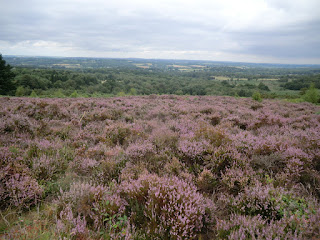
CIMG5930
Heather on Ashdown Forest
Aug-16 • Sean O'Neill
banner, swcwalk110, swcwalks 6387321969944091586 P
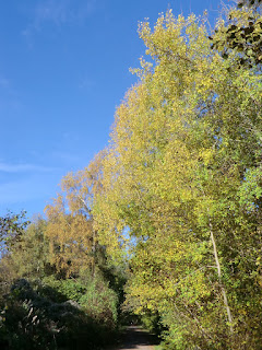
CIMG9278
Autumn colours on the Forest Way
Nov-13 • Sean O'Neill
swcwalk109, swcwalk110, swcwalks, walkicon 5944941839342448786 P

CIMG9278
Autumn colours on the Forest Way
Nov-13 • Sean O'Neill
swcwalk109, swcwalk110, swcwalks, walkicon 5944944200937193570 P


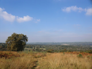
CIMG0833
View from Linton's car park
Oct-15 • Sean O'Neill
swcwalk110, swcwalks, walkicon 6208533622484732594 P
| Length |
Main Walk, to Forest Row: 17¼ km (10.7 miles). Four hours 20 minutes walking time. For the whole excursion including trains, buses, sights and meals, allow at least 9 hours. Extended Walk, to East Grinstead: 22¾ km (14.1 miles). Five hours 40 minutes walking time. |
|---|---|
| OS Map |
Explorer 135. Ashurst, map reference TQ507388, is on the East Sussex/Kent border, between East Grinstead and Tunbridge Wells. East Grinstead is in West Sussex. |
| Toughness |
5 out of 10 (7 for the Extended Walk). |
| Features |
This walk has some overlap with other SWC walks up to Hartfield and the same extended finish as the Eridge to East Grinstead walk (#109·x). Its new middle section takes in a secluded valley and a contrasting stretch on the elevated heathland of Ashdown Forest. After an initial stretch along the low hills above the Medway valley the walk skirts the attractive Wealden village of Hartfield (which you can detour through if you wish) and makes for a country pub in the nearby hamlet of Gallipot Street. After lunch the walk goes over a low ridge and continues alongside the stream immortalised in AA Milne's famous books – though not crossing it at Pooh Bridge itself – before climbing onto an open ridge leading to the Ashdown Forest Centre. A contrasting descent through the wooded Broadstone Warren and a section across a golf course brings you to Forest Row and a choice of places for tea. Buses to East Grinstead leave from the stop outside the Brambletye Hotel if you want to finish the walk here. Alternatively, you can complete an Extended Walk up the long gentle incline of the Forest Way, a popular cycle route along the trackbed of a disused railway line. The route through the hilltop town of East Grinstead goes past many old buildings dating back to the 14thC, including Sackville College (a Jacobean almshouse) and the imposing St Swithun's Church. As with any walk in the High Weald, you will need to be prepared for muddy or waterlogged paths at almost any time of the year. |
| Additional Notes |
An earlier (and tougher) version of this walk included Pooh Bridge and several other places in Ashdown Forest familiar from the books, but suffered from two flaws: a long overlap with the Ashurst Circular walk (#29) and an unsatisfactory lunch pub. This revised version has its own defect, however: an unavoidable 800m alongside a busy road to reach the new lunch pub. The start of the walk was changed again in 2020, reducing the overlap with Walk #29 still further to just §B into Hartfield (done here in the reverse direction). |
| Walk Options |
You can do a Shortened Walk by travelling to East Grinstead and then taking Metrobus 291 to one of the stops on the B2110 between Upper Hartfield and Hartfield. The enterprising landlord of the Gallipot Inn put up a fake bus stop to entice the 291 to stop outside the pub and it is now listed as an official stop! For a shorter and easier walk after Hartfield you could switch to the more northerly route along the High Weald Landscape Trail in Walk #109: the two routes cross just outside the village. Conversely, you could do a longer extension from Forest Row by switching to one of the routes in the East Grinstead Circular walk (#40). You will need to print those directions from the other walk document. |
| Transport |
There is an hourly service from London Bridge to Ashurst (Kent), taking 50 minutes. On Sundays you have to travel from Victoria and change at Oxted, with a longer journey time of around 70 minutes. There is no station in Forest Row, so if you finish the walk there you will need to take a bus from the Brambletye stop up the hill to East Grinstead. Metrobus 270 & 291 alternate to provide a half-hourly service to around 7pm Mon–Sat, plus some later ones in the evening. On Sundays both services are two-hourly to around 6pm. If you want to finish earlier at the Ashdown Forest Centre it is a 1½ km walk along Colemans Hatch Road to the 270 bus stop at Wych Cross (Compass 261 goes past the centre on weekdays but the last bus is at 2.30pm). For the return train journey East Grinstead is on a different line from Ashurst but it is also operated by Southern, with a half-hourly off-peak service to Victoria. The suggested ticket is a return to East Grinstead, which is slightly more expensive and likely to be accepted if checked on the outward journey (there are no ticket barriers at Ashurst station). If driving, there is no direct public transport between the two stations but you could park in Oxted or Hurst Green, where the two lines merge. Oxted station car park is free after 10am (although often full on weekdays). |
| Suggested Train |
Take the train nearest to 10:00 from London Bridge to Ashurst (Kent) for the Main or Extended Walk. If you are doing a Shortened Walk, check the Metrobus 291 timetable and take a connecting train from Victoria to East Grinstead. |
| Train Times |
|
| Timetables |
|
| River Levels |
|
| Lunch |
The suggested lunch place is the Gallipot Inn (01892-770008) on the B2110 at Gallipot Street, after 7¾ km. This attractive old pub is fairly small inside but has a large back garden with fine views across the Weald, and serves good home-cooked food until 2.30pm (all afternoon at weekends). If you detour through Hartfield you could stop half-an-hour earlier at the large Anchor Inn (01892-770424). Alternatively, another detour later in the walk would take you to the Hatch Inn (01342-822363) at Colemans Hatch; this was the walk's original pub stop but it is a restaurant in all but name and has been known to turn walkers away even when not particularly busy. If you are doing a Shortened Walk you might prefer to carry on to one of the pubs in Forest Row, about 11 km from Hartfield. As you go through the village you pass The Swan (01342-822627), the 15thC Chequers Inn Hotel (01342-823333) and The Bram Bar of the Brambletye Hotel (01342-824144). |
| Tea |
There are no permanent refreshment places on the afternoon leg until you reach Forest Row, but the Ashdown Forest Centre has a ‘pop-up café’ on weekends in August and you might also find an ice-cream van in one of the Forest car parks. The route into Forest Row passes Seasons (01342-601010; open to 5pm Mon–Sat, 4pm Sun), an Organic Wholefoods café on Hartfield Road. There are several more places clustered along Hillside and the A22, including Cafe Coco (01342-823136; open to 5pm Mon–Sat, 4pm Sun) and Java & Jazz (01342-826699; open to 7.30pm Mon–Thu, 8.30pm Fri–Sat, 5pm Sun), a pizzeria, gelateria and coffee shop. For stronger fare there are the pubs listed above, plus the Hop Yard Brewing Co (01342-824272), a “music venue, bar and pop-up restaurant”. East Grinstead is not short of places if you need further refreshment after walking up the hill to the town. Two suggested places almost opposite each other on the High Street are the Dorset Arms (01342-316363) at #58 and CJ’s Café Bar (01342-301910; closed Mon) at #55-57, which has a rooftop terrace overlooking the churchyard. You pass these on your way through the town and will need to allow a further 15 minutes to reach the station. |
| Profile | |
|---|---|
| Help Us! |
After the walk, please leave a comment, it really helps. Thanks! You can also upload photos to the SWC Group on Flickr (upload your photos) and videos to Youtube. This walk's tags are: |
| By Train |
Out (not a train station) |
| By Car |
Start TN3 9TL Map Directions Finish Forest Row, Kent Map Directions |
| Amazon | |
| Help |
National Rail: 03457 48 49 50 • Traveline (bus times): 0871 200 22 33 (12p/min) • TFL (London) : 0343 222 1234 |
| Version |
Apr-23 Sean |
| Copyright | © Saturday Walkers Club. All Rights Reserved. No commercial use. No copying. No derivatives. Free with attribution for one time non-commercial use only. www.walkingclub.org.uk/site/license.shtml |


Walk Directions
Click the heading below to show/hide the walk route for the selected option(s).


 Walk Maps
©
Walk Options
Click on any option to show only the sections making up that route, or the heading above to show all sections.
- Main Walk, to Forest Row (17¼ km)
Walk Directions
Click on any section heading to switch between detailed directions and an outline, or the heading above to switch all sections.
If you take bus 291 from East Grinstead to Hartfield, start at §C. Either get off at the Castlefields stop at the far end of the village and do the main route in [?], or at the Church Street stop and join the alternative route from the Anchor Inn.
If you take bus 291 from East Grinstead to Upper Hartfield or Gallipot Street, start at §D. If not visiting the Gallipot Inn you could get off earlier at the Garage stop and start at [?].
- Ashurst Station to Beech Green Lane (2¾ km)
- Go out to the A264 and turn left. After going under the railway and across the River Medway take a footpath on the left heading south-west up to Lodgefield Farm. Turn left onto a bridleway heading south to Beech Green lane.
- Turn left out of the station, go down its access road and turn left onto the A264. Follow it under the railway bridge and over the River Medway, crossing into East Sussex. After an awkward 125m along the grass verge of this busy main road bear left into a lay-by. Halfway along go over a stile next to a metal fieldgate and follow a path (slightly to the right) through a neglected orchard.
- At the end cross a ditch on a plank bridge and turn right onto a fenced path going up the right-hand side of a meadow. At the top go over a stile and continue on a grassy path slanting up another meadow. Follow it round to the right and go over a stile onto a wide concrete track. After passing some farm buildings go up a flight of steps cut into the bank ahead.
- At the top turn left onto another concrete track, a public bridleway. Ignore a footpath off to the right and go through a wooden gate ahead onto a grassy path between hedges, heading S. Follow this path alongside a meadow and down a short slope. After a short stretch with views across the Medway valley on the left the path goes through a copse and comes out into the top corner of another large meadow, sloping down to the right.
- Follow a grassy path along its left-hand edge. At the far end go through a wide gap and bear right onto a tarmac driveway. Ignore turnings off to the left to Priory Park and Blackham Court and follow the main drive for 400m, over a low rise and curving gently round to the left. Where the drive bends right keep ahead on a rough track, the continuation of the bridleway.
- For the main route follow the bridleway uphill through a wood. At the top keep ahead on the driveway from Hale Court Farm, passing some cottages off to the left and later a pond on the right. The driveway comes out onto Beech Green Lane.
- Beech Green Lane to Hartfield (Castlefields) (2¾ km)
- Turn right onto the lane. In 500m turn left onto a footpath leading to Top Hill Farm. Turn left there onto a footpath heading south and then south-west down to and across the River Medway. Cross the Forest Way and continue across fields into Hartfield.
- Turn sharp right onto the lane. You have to go along this minor road with no pavement for 500m, but it is fairly wide and does not usually have much traffic. Just before the private drive from Blackham Court turn left into the gated driveway to Top Hill Farm, with a footpath signpost pointing along it from across the road.
- Use a stile in the hedge on the left to skirt around the electrically-operated gate and follow the driveway between paddocks, heading W. In 350m ignore a footpath off to the left at Walstead Stud and keep right by the entrance to Top Hill Farm. After passing some stables the drive ends at a fieldgate in front of a grassy track, with a three-way footpath signpost.
- Go through the gate and turn left. Go through a wooden barrier onto a fenced path alongside a paddock, passing a large outbuilding and then a hedge on your left. Follow the path through a small wood and out into the top corner of a large field.
- Keep ahead across a farm track and continue along the left-hand field edge, gently downhill and with Hartfield's church spire visible in the valley. In about 100m, before the field edge curves round to the left, turn half-right and follow a clear path down across the field. At the bottom of the field go through a gap (via two stiles if necessary) and keep ahead on a path with a fence on the right, still downhill.
- In 150m cross the River Medway on a footbridge and go straight across the Forest Way? (Cycle Route 21) into a field. Turn half-right to go diagonally across it to a wide gap in the hedge near the far corner. Go through this and turn right to go along the edge of two more fields, gradually curving round to the left.
- In the far corner of the last field go over a stile and take the right-hand of two footpaths indicated, down through a potentially boggy area. Cross a ditch at the bottom of the dip and bear left onto a grassy path which curves up towards some houses on the outskirts of Hartfield, with a small mound? up ahead on your right.
- In the top corner go over a stile onto a tarmac path. Turn right onto a residential street (Mottefield) and then left into Castlefields. At the end turn right onto the B2110, where there is a bus stop and a gate opposite leading onto a green.
- Castlefields to Gallipot Street (2¼ • 1½ km)
-
 For the main route, skirt around the village by taking a footpath from the B2026 back to the Forest Way and head west on this cycle route for 500m, then turn left onto a bridleway heading south to the B2110; turn right and go along this road to the Gallipot Inn.
- Alternatively, you can go via the churchyard and Church Street back to the main road by the Anchor Inn, then follow the B2110 all the way to the Gallipot Inn.
-
Main route (2¼ km)
- To bypass the village, go along the B2110 to its junction with the B2026, with a Farm Shop opposite. Cross the side road carefully and take the signposted footpath just off to the right, along the driveway to “Wyndham”. Go through a metal side gate and along the left-hand edge of two small fields, curving slightly to the left.
- At the end of the second field go through a potentially muddy gap in the hedge and turn right onto a grassy path a little way out from the field edge, leading to a wooden fieldgate in the tree boundary. Go through this and over the Forest Way (the disused railway line you crossed earlier).
-
On the other side of the brick bridge turn right down a steep little path and then turn sharp right onto this cycle route, going under the bridge. In 250m keep ahead at a path crossing.
You are crossing the route of Walk #109, on the High Weald Landscape Trail.
- In a further 250m, just before reaching a bridge with metal lattice sides, veer left onto a path down the embankment and turn left onto the bridleway at the bottom. Go through a metal gate and follow a grassy path half-right towards the corner of a wood.
-
Go through another metal gate and follow an invariably muddy bridleway up through the aptly-named Rough Wood.
There are unofficial paths up on the right-hand bank (and then through the adjacent woodland) which would allow you to escape the worst of the mud.
- At the top leave the wood through another gate and continue on an enclosed grassy track heading S towards distant farm buildings. Keep ahead through the farmyard onto a track going uphill past a few houses, coming out onto the B2110 opposite the imposing entrance to “Landhurst”.
- Turn right onto the road, crossing over carefully to use the footway on the other side. In 300m you come to the suggested lunch pub on the right, the Gallipot Inn?.
-
Alternative route (1½ km)
-
To go through the village, cross the B2110 and go through a gate opposite (slightly to the right) onto a green. Follow the tarmac path towards the church and continue up a driveway to the left of a private drive, passing the village school.
-
Enter the churchyard of St Mary the Virgin? and keep ahead along its right-hand side, passing a magnificent tulip tree. Exit under part of Lych Gate Cottage? and turn right down Church Street, where the Anchor Inn is on the right at the T-junction with the High Street. Turn left onto the main road through the village.
Opposite the Village Stores the Hay Waggon still looks like Hartfield's alternative pub, but it has been elegantly converted into a pair of houses.
- Further along the High Street you pass Pooh Corner (with Piglet's Tearoom) on the right. At a road junction fork right to stay on the B2110, up Newtons Hill.
-
The main route rejoins from a farm drive on the right after 500m, opposite the imposing entrance to “Landhurst”. In a further 300m you come to the Gallipot Inn? on the right.
- Gallipot Street to Newbridge (3¼ km)
- Turn right out of the pub and go along the B2110 for 500m. In the centre of Upper Hartfield take the bridleway heading south-east for 200m, then turn right onto a footpath leading to Marsh Green. Turn right onto Marsh Green Lane for 500m and continue on a footpath past Newbridge Mill to a road, Kidds Hill.
- Turn right out of the pub for another 500m of road walking on the B2110, climbing gently at first. After the road levels out you go alongside a row of houses in Upper Hartfield, with a bus stop at the end just before a minor road junction and a garage.
- At the junction take the private road opposite Parrock Lane, signposted as a bridleway and heading SE. Go along this lane for 200m, curving round to the right and ignoring a couple of driveways off to the left. Where the lane turns sharply left, go over a stile on the right and along the right-hand edge of a field.
- In the far corner go over another stile onto an enclosed path. In 100m ignore a private gate on the left into the corner of a field and follow the path to the end, where there is a stile in the hedge into the same field. Follow a grassy path down the middle of the field (with a fine view of Ashdown Forest ahead), towards the right-hand end of a wood.
- At the bottom go over a stile and turn right onto a broad grassy strip. This leads to a T-junction where you turn left onto a tree-lined track. In 100m (with the entrance to “Forest Springs” ahead) turn right off the track onto a broad path, initially with a chainlink fence on your left. In 175m the path turns half-left and goes downhill.
-
In 150m another footpath joins from the right and there is a wooden bench on your left. Continue downhill on the broad track, with a field on your right. In 75m fork right as indicated, soon crossing over a private driveway. Follow the path towards some trees and onto a wooden footbridge across Millbrook.
This is your best opportunity for a game of Pooh Sticks, away from the crowds at Pooh Bridge (which is 1 km downstream, not on the walk route).
- On the far side the path leads into a driveway which you follow past a few houses to a minor road (Marsh Green Lane). Turn right and go along this quiet lane for 500m. You eventually come to a Y-junction where you fork left briefly into Steppey Lane, where there are two fieldgates on the right. Go over a stile next to the second gate.
- Head directly away from the lane and continue in this direction across four fields, negotiating stiles and gates as necessary. The fourth field has an irregular shape and unless there is some temporary fencing to indicate the right of way, the exit may not be immediately obvious. Aim just to the left of a projecting hedge 125m ahead; as you go alongside it you will find a path dropping down through a narrow gap in the hedge.
- Go through a new wooden gate and across a stream on a footbridge. Turn left to follow the path through the garden of Newbridge Mill?, then round to the right in front of the attractive mill building. Join its driveway to cross Millbrook and go through a wooden fieldgate. Where the drive turns left keep ahead up a broad grassy strip as indicated. Turn left at the top to come out onto a road (Kidds Hill).
- Newbridge to Colemans Hatch Cricket Club (¾ • 1¼ km)
-
For the main route cross Kidds Hill and go up the farm drive opposite, then continue on a horse ride and woodland path to the cricket club.
- If you want to visit the Hatch Inn, turn right onto Kidds Hill and follow the road all the way to the pub in Colemans Hatch. Afterwards, turn left onto Colemans Hatch Road and in 400m fork left along a driveway leading to a number of properties and the cricket club.
-
Main route (¾ km)
- Cross the road carefully and go up Portobello Farm's driveway opposite, entering the Open Access land of Ashdown Forest?. After climbing steadily for 250m the drive levels out. Where it bends left keep ahead on a horse ride which itself turns left, staying fairly close to the drive.
-
In 75m turn right at a junction onto another broad ride, soon coming out of the trees into a more open area. In 300m, shortly before it curves gently round to the left, fork right onto a narrow but well-defined path through a wooded area, soon with glimpses of a cricket pitch through the trees on your left.
- If you see the cricket pitch on your right you have missed the woodland path, but in that case simply take the long way around the pitch to the pavilion (in the process getting a better view of any game that happens to be in progress).
- The woodland path briefly goes alongside the pitch and then past the back of the pavilion. Cross a tarmac lane and bear left onto a broad grassy ride heading W (not the horse ride on its right, going up past a bowling green).
-
Alternative route (1¼ km)
-
For an alternative lunch place turn right onto Kidds Hill. In 600m you come to the Hatch Inn on your left, just before a small triangular green. Afterwards you can leave via a gate at the bottom of its beer garden and turn left onto Colemans Hatch Road.
- Alternatively, continue past the pub on Kidds Hill, turn left in front of the green onto a short link road and then left again onto Colemans Hatch Road.
- There is 400m more road walking. You pass an elaborate horse trough?, then the imposing gates for South Hartfield House. After passing some cottages ignore two driveways off to the left, but 100m later turn left into the second of two more driveways, with signs for eight or nine properties.
- In 300m, with a cricket pitch and pavilion on your left, bear right onto a broad grassy ride heading W.
- The Cricket Club to the Ashdown Forest Centre (1¾ km)
- Go along the ridge parallel to Colemans Hatch Road. The suggested route is to the south of the road for the first half of this section, crossing over at Linton's car park; this gives the best views but in practice you can take any convenient route along the ridge.
-
Stay on the main ride, which curves slightly left to head SW, parallel with Colemans Hatch Road 150m off to the right. In 400m ignore a turning off to this road and swerve left and right to continue in much the same direction.
There are fine views back to your left of another part of Ashdown Forest, around Gills Lap Clump.
- In a further 250m another ride merges from the left and you now turn right onto a path which takes you through a seasonal car park to the road. Cross the road and go through Linton's car park onto an open area, with fine views ahead of the distant Greensand Hills.
-
Bear left down the slope to join a broad ride running parallel to the road, heading W along the hillside. Follow it for about 800m, passing Millennium Clump (planted in 2000) on the left along the way. As you approach a large wood fork left towards the car park for a large wooden building half-hidden in the trees, the Ashdown Forest Centre.
The building contains offices and an Information Centre with exhibitions. There is no permanent café but refreshments might be available inside on summer weekends.
-
Finishing in Wych Cross (+1½ km)
- Leave through the visitor centre car park and turn right onto Colemans Hatch Road. Follow it all the way to traffic lights and turn left onto the A22. The bus stop for Forest Row and East Grinstead is on the other side of the main road, opposite the Roebuck Hotel.
- The Ashdown Forest Centre to the Golf Clubhouse (2¼ km)
- Go along the road briefly and turn right onto a footpath heading north through the wooded Broadstone Warren, initially along a driveway and then a clear woodland path. Shortly before this emerges onto a golf course, fork left at a footpath junction. Follow the path down through the trees, across a golf fairway and up towards the clubhouse.
-
The continuation of the walk is along a driveway beyond the Forest Centre, but unless the exit leading to it is unlocked you will have to leave through the visitor car park; turn right onto the road and then right again at the footpath signpost after 150m. Follow the tarmac drive past the back of the buildings and down through the wooded Broadstone Warren.
This is outside Ashdown Forest, so not Open Access land.
- You will be going down this long driveway for 500m and the turning off it is now properly signposted. Shortly before the drive reaches the boundary of a private property veer left and then right as indicated to continue in much the same direction on an earth track.
-
In about 50m fork right as indicated and now simply follow the clear path for 800m on its long descent through the wood, heading N. About 100m before the path emerges onto a golf course fork left at a waymarked footpath junction.
Through the trees you might just be able to see the golf clubhouse, ahead on your left. The right of way shown on older OS maps heads directly towards it across the course, but the footpath appears to have been diverted to skirt around all but one fairway.
- Follow the woodland path down through the trees, heading roughly NW. On reaching a large old yew tree the path swings right. Keep ahead at an oblique path junction (now back on Open Access land) and go down through the trees to the edge of a golf fairway, with a green off to the right and golfers playing from the left.
- The continuation of the footpath is the prominent wooden footbridge on the fairway, which crosses a brook in front of the green. When no-one is playing towards the green, make your way across the footbridge and onto a driveway going uphill between a golfers' car park and the clubhouse.
- The Clubhouse to Forest Row (1½ km)
-
 Follow the golf club's driveway out to Chapel Lane. Continue down this road, turning left onto an enclosed footpath near the bottom to cut across a small green. Go along the B2110 into Forest Row, passing a couple of tea places. Just before the A22 turn right down Hillside to pass some more places. If you are finishing the walk here, the bus stop is on the A22 where it merges with Hillside.
-
Follow the driveway out of the golf course, taking care as you cross two more fairways (with appropriate warning notices). In 300m the drive bends left and merges with another lane. Shortly before it comes out onto Chapel Lane, veer right at a footpath waymarker (and a wooden sculpture for the Vanguard Way?) to cut through the trees and join this residential street a little further down.
- Go downhill on Chapel Lane for 300m. 150m before its T-junction with the B2110, turn left onto a tarmac path with a footpath waymarker, to the left of “Blue Cedar”. This zig-zags right and left and continues diagonally across a green, crossing a private road in the middle. On the far side bear left onto the B2110, crossing over at some point and passing a couple of small recreation grounds.
- Go across Station Road and follow the B2110 up past a parade of shops, with Seasons on the right-hand side and the Hop Yard (accessed through a florist's shop) on the left. Just before the roundabout with the A22 turn right down Hillside, passing the small village green, War Memorial and the distinctive Freshfield Hall? on your left.
-
The Swan is on the far side of the A22. If you stay on Hillside you pass Cafe Coco, the Chequers Inn Hotel and finally Java & Jazz on the right, with the Brambletye Hotel? opposite.
-
If finishing the walk here, the bus stop for East Grinstead is on the A22 outside the Brambletye.
-
If finishing the walk here, the bus stop for East Grinstead is on the A22 outside the Brambletye.
- Forest Row to East Grinstead Station (5½ km)
-
 Head north briefly along the A22 and bear left onto the Forest Way cycle route immediately after crossing the River Medway. Follow this all the way into the outskirts of East Grinstead, forking left near the end to come out at a major roundabout. Turn left onto Lewes Road and keep ahead where this becomes the town's High Street. At a mini-roundabout turn right into London Road. Go straight on at traffic lights, then turn left into Railway Approach. Go over a major roundabout to reach the station.
-
From any of the tea places make your way to the A22 and head N on the main road. Just after the road crosses the River Medway, bear left at the pedestrian traffic lights onto the Forest Way, signposted as Cycle Route 21. In 700m the track crosses Brambletye Lane and goes into a deep cutting.
- If you wish you can fork left onto a narrow path along its top, with views out to the left including the ruins of Brambletye House?. This side path eventually drops down to rejoin the main track.
- The later stages of the Forest Way are on a high embankment, with glimpses through the trees of the countryside beyond. On reaching the outskirts of East Grinstead, go straight across Herontye Drive and fork left up an incline to come out in front of a large roundabout, with the A22 continuing on Beeching Way? on the far side.
-
Turn left onto Lewes Road, heading W towards the town centre. In 250m keep ahead at a road junction into the town's ancient High Street, with a bronze monument? in honour of Sir Archibald McIndoe in front of Sackville College?. You then pass the imposing church of St Swithun? on the right.
- Two suggested tea places nearby are CJ’s Café Bar in front of the church, with the Dorset Arms across the road. At the end of the High Street turn right at a mini-roundabout to go down London Road, passing more refreshment places.
-
Keep ahead at a road junction with traffic lights, then 100m later turn left into Railway Approach. At the far end you have to negotiate a large roundabout to reach the station opposite. It is a terminus and trains can leave from either platform, but most leave from Platform 2, on this side.
- The Forest Way runs for 17 km between East Grinstead and Groombridge, along part of a branch line closed by Beeching in 1966. It is now a popular cycle route.
- The mound is all that remains of an old Motte and Bailey fortification, as indicated by the nearby street names Mottefield and Castlefields.
- St Mary the Virgin, Hartfield is a mixture of styles dating from the 13th–15thC, but was heavily restored in Victorian times.
- Lych Gate Cottage does indeed incorporate the gate into the churchyard, an unusual arrangement.
- The Gallipot Inn was originally three Tudor cottages. One had been used for producing medicines and ointments in small glazed earthenware pots, or ‘gallipots’.
- Newbridge Mill is on the site of one of England's first blast furnaces. This hamlet was the centre of a busy iron-producing area in the 16thC.
- Ashdown Forest did not impress William Cobbett. A diary entry from January 1822 recorded in his Rural Rides vividly describes it as “verily the most villainously ugly spot I saw in England…getting, if possible, uglier and uglier all the way”.
- The horse trough on Colemans Hatch Road commemorates Sir Spencer Walpole (1830-1907), an English historian and civil servant.
- The Vanguard Way runs for 105 km “from the suburbs to the sea”, from Croydon in south London to Newhaven in East Sussex.
- Freshfield Hall was a memorial gift from the Freshfield family following the death of their young son in 1891. The original hall burnt down in 1895 and had to be rebuilt.
- The Brambletye Hotel was frequented by Sir Arthur Conan Doyle and features in his Adventure of Black Peter: Sherlock Holmes and Dr Watson stay at this inn while investigating the murder of a retired sea captain.
- Brambletye House was built in 1631 by Sir Henry Compton, lord of the manor. A later owner, Sir James Richards, was suspected of treason in 1684 and fled the country, leaving the house to decay. It features in the 1826 Horace Smith novel Brambletye House.
- Beeching Way is where the branch line continued through the cutting now used by the A22. It seems a pity that the rather more appropriate name of “Beeching Cut” was rejected.
- The monument depicts a seated airman being comforted by Sir Archibald McIndoe, a plastic surgeon whose innovative surgical techniques at the nearby Queen Victoria Hospital greatly improved the rehabilitation of wounded aircrew in World War Ⅱ. The sculptor was Martin Jennings, whose father had been one of McIndoe's patients.
- The Jacobean almshouse Sackville College was founded in 1609 with money left by Robert Sackville, 2nd Earl of Dorset, and is still in use today. The building can be visited on some afternoons in summer.
- The present St Swithun, East Grinstead dates from 1789, but there has been a church here since the 11thC (Swithun was a 9thC Bishop of Winchester). Previous buildings on this prominent hilltop site were often struck by lightning and the church has been rebuilt several times over the centuries.
There is a choice of routes, with the main route skirting around the village. The alternative route in [?] is almost entirely alongside a busy road (the B2110) and is only suggested if you want to visit the earlier lunch pub in the village.
The alternative route in [?] has only been included in case you want to visit the Hatch Inn; it is mostly along country lanes with no pavement.
If you want to finish the walk here you will probably have to walk to Wych Cross for the 270 bus (the stop outside the centre is for the infrequent 261).
For simplicity this extension follows the Forest Way all the way up a gentle incline to East Grinstead. There are more varied and stimulating alternatives but they can be boggy and not always easy to follow.
Walk Notes
» Last updated: April 10, 2023
Return to Top | Walk Map | Walk Options | Walk Directions.