Huntingdon Circular walk
Easy walk beside the Great Ouse river to the attractive village of Houghton and its restored water mill, returning through water meadows and a nature reserve.


CIMG7945
Geese at Godmanchester Nature Reserve
Jul-13 • Sean O'Neill
swcwalk31, swcwalks, walkicon 5907215045308462978 P

CIMG8914
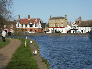
Cottage, Hemingford Abbots
Jul-15 • Sean O'Neill
swcwalk31, swcwalks, walkicon 6170665607867268754 P

| Length |
Main Walk: 18¾ km (11.6 miles). Four hours walking time. For the whole excursion including trains, sights and meals, allow at least 9 hours. Long Walk, extended via St Ives: 24¾ km (15.4 miles). Five hours 25 minutes walking time. |
|---|---|
| OS Map |
Explorer 225. Huntingdon, map reference TL234716, is in Cambridgeshire, 24 km NW of Cambridge. |
| Toughness |
2 out of 10 (3 for the Long Walk). |
| Features |
This easy circular walk leaves the historic town of Huntingdon via a linear park on the north bank of the River Great Ouse. The riverside path on this bank takes you as far as Hartford, where the walk continues along the edge of farmland to an early lunch stop in the attractive twin villages of Houghton and Wyton. At Houghton there is a choice of routes for the central leg of the walk: the original version continued with a straightforward circuit of Houghton Meadow, and this remains the Main Walk. The Long Walk replaces this section with an extended loop via the neighbouring villages of Hemingford Abbots and Hemingford Grey to the next town along the river. St Ives has been an important market town since Anglo-Saxon times, when it was the last place where the River Great Ouse could be forded before it reached the sea, 80 km away. The 15thC town bridge has several unusual features, most notably the survival of its late-medieval Bridge Chapel. The town's Norris Museum (free entry) “tells the story of Huntingdonshire from earliest times to the present day”; it is open daily (except Sundays in winter) until 4pm. Both options return via water meadows to the last working water mill on the river, Houghton Mill; this is operated by the National Trust but visits are currently by pre-booked tour only. The final leg back to Huntingdon is through a nature reserve and more water meadows which are awash with buttercups in spring. The town's old grammar school (where Oliver Cromwell and Samuel Pepys were pupils) now houses the Cromwell Museum (closed Mon; free entry but limited opening hours, especially in winter). On the Long Walk you could visit The Manor Garden in Hemingford Grey, designed and planted by the author Lucy Boston and recreated as Green Knowe in her books for children. It is open 11am-5pm (or dusk); admission is £6 (2023). A relatively high proportion of this walk is on tarmac paths and lanes, with the whole route never more than 20 metres above sea level. Water meadows are obviously prone to flooding and this walk may not be feasible in winter, or after very heavy rain. |
| Walk Options |
On the Main Walk you could save 3½ km by omitting the circuit around Houghton Meadow, or up to 2 km by taking a shorter route through it. Conversely, the Long Walk bypasses this meadow on its return route but you could switch to the full circuit around it, an additional 2 km. Towards the end of the walk a couple of short cuts are available if you are in a hurry to catch a train. |
| Transport |
Huntingdon is on the East Coast Main Line. On weekdays there is a half-hourly cross-London Thameslink service via East Croydon, London Bridge and St Pancras; on Sundays there is an hourly service from Kings Cross. The journey time is about one hour from central London. There are two bus routes from St Ives to central Huntingdon, with some services continuing to the station. Stagecoach Busway B runs half-hourly (hourly Sun & BH), with half of the services going along the A1123 to the north of Houghton; Stagecoach 904 runs hourly (Mon–Sat) and goes through Houghton and Wyton. There are no useful bus services in the Hemingfords. If driving, the station car park at Huntingdon costs £4.30 after 10am Mon–Fri, £3.40 Sat–Sun (2023). |
| Suggested Train |
Take the train nearest to 10:15 from St Pancras or Kings Cross to Huntingdon. If you are doing the Long Walk and are planning to have lunch at one of the later pubs, leave an hour earlier. |
| Train Times |
|
| Timetables |
|
| River Levels |
|
| Lunch |
The suggested lunch stop (after 6½ km) is the Three Jolly Butchers (01480-463228) in Wyton, which has a large garden and serves good home-cooked food. A little further on in Houghton, the Three Horseshoes Inn (01480-462410) is a good alternative. On the Long Walk two more options would allow you to complete more of the walk before stopping. A third of the way round (after 8½ km) the Axe & Compass (01480-463605; closed Mon & Tue) in Hemingford Abbots is a traditional village pub with a large beer garden. The most up-market choice would be the National Pub of the Year 2019, The Cock (01480-463609; closed Mon) in Hemingford Grey (1 km further on), serving excellent food until at least 2.30pm. |
| Tea |
In summer the Houghton Mill tearoom (01480-301494) is a convenient place to stop for tea, with its wholemeal scones being made from flour ground at the mill; it is open daily to 5pm from mid-March to September, Wed/Sat/Sun only in winter. There is also the tiny Houghton Tea Room (07894-950151; open to 4pm Wed–Fri, 3.30pm Sat & Sun) in the village square. On the Long Walk there are several refreshment places in St Ives for a mid-afternoon break (or a late lunch), but none have been tried. At the end of the walk there are several pubs and cafés in Huntingdon town centre, plus a small buffet at the station. The suggested watering-hole is the George Hotel (01480-432444) in George Street, an old coaching inn with a comfortable bar and a large open courtyard (used for staging Shakespeare's plays). On the way to the station the walk route also passes Sandford House (01480-432402), a JD Wetherspoons pub. |
| Profile | |
|---|---|
| Help Us! |
After the walk, please leave a comment, it really helps. Thanks! You can also upload photos to the SWC Group on Flickr (upload your photos) and videos to Youtube. This walk's tags are: |
| By Train |
Out (not a train station) Back (not a train station) |
| By Car |
Start PE29 3BP Map Directions |
| Amazon | |
| Help |
National Rail: 03457 48 49 50 • Traveline (bus times): 0871 200 22 33 (12p/min) • TFL (London) : 0343 222 1234 |
| Version |
Jun-23 Sean |
| Copyright | © Saturday Walkers Club. All Rights Reserved. No commercial use. No copying. No derivatives. Free with attribution for one time non-commercial use only. www.walkingclub.org.uk/site/license.shtml |

Walk Directions
Click the heading below to show/hide the walk route for the selected option(s).


 Walk Map
©
Walk Options
Click on any option to show only the sections making up that route, or the heading above to show all sections.
- Main Walk (18¾ km)
Walk Directions
Click on any section heading to switch between detailed directions and an outline, or the heading above to switch all sections.
- Huntingdon Station to Old Bridge (1 km)
- Cross the car park and the A1307 onto Mill Common and take the path across it, heading east. Go across a side road and round the back of Mill Common car park. Take a path which goes along the side of Castle Hills to Old Bridge and cross the road into Riverside Park.
- Arriving from London, cross the footbridge to leave the station via the ticket office on the far side. Go straight across the car park and cross the new Mill Common Link Road (the A1307) at the traffic lights. Go through a gate onto Mill Common and take the surfaced path across it, heading E.
- At the corner of some housing follow the main path briefly round to the left and then bear right onto a grassy path. On the far side of the common go through a wooden gate in the fence onto a side road. Cross this at the traffic lights and continue briefly alongside the ring road, passing a car park on the right.
-
At the back of the car park turn right onto a tarmac path signposted to houses 10·11·12 on ‘The Walks East’. Just before it comes out onto an unsurfaced lane (Castle Hill), turn left onto an enclosed path which continues along the left-hand side of another open area, Castle Hills?.
- At the far end of Castle Hills a small detour up to the prominent fire beacon would take you to an information panel about the area's history.
- The path out of Castle Hills leads back to the ring road. Bear right and follow it to traffic lights by the Old Bridge Hotel. Cross the junction into Riverside Park and take the tarmac path down to the water's edge in front of Bridgefoot House for a fine view of the medieval Old Bridge? and Riverside Mill (now converted into apartments) opposite.
- Old Bridge to Huntingdon Road (3 km)
- Go through Riverside Park and continue along a path to Hartford church, where the riverside path ends. After a short stretch on the B1514, cut through The Grove to a bus lane and cycleway leading to the A1123 (Huntingdon Road).
- You will be following the riverside path for 1½ km through this linear park, with the River Great Ouse on your right. In 400m the path takes you around the left-hand side of a children's playground; fork right on the other side to go back towards the river.
- Near the end the surfaced path goes through the centre of a small meadow, with mown paths off to both sides which you could also take. All routes lead to a short path through a copse on the far side, emerging onto Church Lane (Hartford) at a bend. Bear right onto the lane to continue in much the same direction, later passing a small car park on the right.
- At the far end keep ahead past All Saints church?, either through the churchyard or on the narrow riverside path to its right. This is as far as you can go on this bank of the river, so take the short lane (The Hollow) leading up to the B1514, with the Barley Mow pub opposite.
- Turn right and go along the main road for 125m, then turn right again into The Grove. Follow this unsurfaced road past houses, round to the left in front of the entrance to “Greyfriars” and out to a T-junction with a bus lane and cycleway. Turn right and go along this to the A1123 (Huntingdon Road).
- Huntingdon Road to Wyton (2½ km)
- Just past the Marina take the bridleway leading away from the river. Follow it round to the right to continue parallel to the A1123 before turning back to meet it. Cross over the main road and take the residential street opposite (Ware Lane) to the Three Jolly Butchers pub in Wyton.
- Veer right onto a tarmac path running parallel to the A1123, screened by a row of trees. At the entrance to Hartford Marina go back to the main road and cross it carefully at the traffic island. Continue alongside it for 75m and then turn left onto an unsurfaced track (signposted as a public bridleway). Go past a wooden fieldgate for Hartford Lake, with the fishing lake behind trees on your left.
- In 250m the track comes to the gated entrance to a house on the left. Keep ahead on a path between hedges, the continuation of the bridleway. In 150m this turns right and and becomes a broad grassy path heading E alongside a line of poplars, later with large farm fields on both sides.
- In 500m keep ahead where the path joins an unsurfaced track, and again where it joins the driveway to Manor Farm. Later, where the drive curves away to the right and there are footpaths on both sides, keep ahead on a grassy path signposted as the continuation of the bridleway. There are farm fields off to the left and a water tower visible on the horizon.
- The path makes its way back towards the A1123 and eventually swerves right to meet it. Cross the main road carefully and take a tarmac path just off to the left, through a gap in a wooden fence and out onto a residential street (Ware Lane). Go all the way along it to its T-junction with Huntingdon Road. The suggested lunch pub on the Main Walk is directly opposite, the Three Jolly Butchers in Wyton.
- Wyton to Houghton Mill (4 • 2 • ½ km)
-
 Go along Huntingdon Road into the neighbouring village of Houghton with its alternative lunch pub, the Three Horseshoes Inn. For the circuit of Houghton Meadow, head east on Thicket Road. Turn right into Sandy Lane and follow it into this large meadow. Make a clockwise circuit around it, returning on the riverside path to Houghton Mill.
- Alternatively, simply head south on Mill Street from the square to go directly to Houghton Mill. Several other short cuts allow you to bypass the meadow or take a shorter route through it.
- If coming out of the pub, turn right to head E along Huntingdon Road. In 250m this narrow street swings right and leads into Houghton's small village square, known as The Green?. The Three Horseshoes Inn is on its left-hand side, and in the opposite corner the Houghton Tea Room is behind the statue of a Victorian philanthropist, Potto Brown?.
-
Direct Route (½ km)
- To go directly to the mill take the street to the right of the statue (Mill Street), heading S. After passing St Mary's church? keep ahead where the road turns sharply left for a picturesque view of Houghton Mill across the millpond. Go up to the mill entrance and resume the directions at §I.
-
For the longer routes take the street to the left of the statue (Thicket Road), heading E and passing some attractive cottages (the old Manor House, the Miller's House, etc). In 200m ignore footpaths off to both sides, and later another on the right after the road has curved right and left. It then straightens out for 300m, passing some magnificent trees in the parkland on the left.
- Where the road swings left at the end of this stretch, veer right through a small parking area. Go past a metal fieldgate by a small pump house onto a broad track (Sandy Lane), heading S. In 300m, after going past fieldgates on both sides and before the track goes up a small slope, there is a broad path off to the right with a ‘New Public Footpath’ sign.
-
Short Cut (2 km)
- To bypass Houghton Meadow veer right onto this fenced path, which soon straightens out to head W. In 250m it swings right in front of a backwater with some rotting timber supports, all that remains of an old railway? bridge across the river. In a further 150m keep ahead where the longer route joins from across a footbridge on the left and resume the directions at [?].
-
For the main route
carry on along the track, up the slope and across Houghton Trout Stream. The track curves left and a wooden gate takes you into Houghton Meadow, with a choice of two grassy paths ahead. For the full circuit take the left-hand path, heading SE between the stream and a wire fence.
- The right-hand path provides a couple of shorter routes through this meadow. At a path junction after 200m both routes lead to the main river, where you would turn right onto the riverside path and resume the directions at [?] (if you turned right at the junction) or [?] (if you carried straight on).
- You now simply follow this meandering riverside path, keeping the fence on your right. In 600m it swings right to head S and then SW, now alongside Hemingford Grey Backwater. In 250m there is a good view of Hemingford Grey church off to the left, 200m away. In a further 300m a path joins from the right.
- Go through a metal kissing gate in the hedge ahead. After passing Six Gates Weir on the backwater the path is now alongside the main River Great Ouse. It gradually curves right and after 500m you are heading N, where another path joins from the right.
- Go over a footbridge in the hedge ahead. In 250m you cross another pair of footbridges at Trout Stream Weir, where some rotting timber supports in the backwater are all that remains of an old railway? bridge across the river. After crossing another footbridge turn left at a T-junction, where the shorter route joins from the right.
-
Follow the main path as it heads NW alongside a hedge, ignoring a path off to the right. You soon go through a wooden kissing gate by a NT sign for Houghton Mill (Water Close Meadow) and continue past a caravan site on your right. Go alongside the large millpond to come to the National Trust tearoom at Houghton Mill.
- If the NT tearoom is closed and/or you want to try an alternative place before the long stretch to Huntingdon town centre (7½ km away), go past the mill entrance into Mill Street. Follow it sharply round to the right and past St Mary's church to come to the two places you passed earlier in the village square, the Houghton Tea Room and the Three Horseshoes Inn. Return the same way.
- Wyton to Hemingford Abbots (2 km)
- Go along Huntingdon Road into the neighbouring village of Houghton and head south on Mill Street, joining the Pathfinder Way (PW). Follow the passageway through Houghton Mill and cross the river at Houghton Lock. Go straight across Hemingford Meadow and cross another branch of the river at Black Bridge. At the end of Meadow Lane turn left (leaving the PW) and go along Common Lane into Hemingford Abbots.
- Unless stopping at the pub, turn left …
- Take the street to the right of the statue (Mill Street), heading S and briefly joining the Pathfinder Way?. ….
- Take the path through the mill building in a covered passageway. Follow the path over Houghton Mill Sluice, past an information panel for the Ouse Valley Way? (OVW) and over the footbridge at Houghton Lock into Hemingford Meadow. There is a four-way signpost and a surfaced path across the meadow.
- To head for St Ives keep ahead on the surfaced path. In 500m you cross another branch of the river on Black Bridge and continue on a lane. In 200m this comes to a T-junction where you turn left, leaving the Pathfinder Way.
-
Go along this road (Common Lane) into Hemingford Abbots, passing a number of attractive old cottages. In 500m keep left at a road junction to continue along its High Street. The next possible lunch stop is on the left at the junction with Church Lane, the Axe & Compass pub.
- A detour along Church Lane would let you visit St Margaret's church? before continuing the walk.
- Hemingford Abbots to Hemingford Grey Meadow (2 km)
- From the High Street take a footpath running close to the river into Hemingford Grey. Leave the village on Church Street and turn left onto a footpath (Love Lane) heading north-east. Continue along Meadow Lane to Hemingford Grey Meadow.
- Continue along the High Street for 150m, heading SE. After passing Manor Lane and a long half-timbered thatched cottage on the left, turn left onto a public footpath signposted to the river and Hemingford Grey.
- The path goes across two meadows separated by a small copse. The river is on your left and along the way you pass an inconspicuous wooden gate on your right, the back entrance to Hemingford Manor Garden?. The path leads into the end of the High Street in Hemingford Grey.
-
Main route
- Veer left off the lane to continue on a signposted footpath between some cottages and their gardens. At the end of this short path bear right into Church Street, perhaps after a quick visit to St James' church?. In 50m the alternative route joins from Church Lane on the right.
-
Alternative route
- Bear right and go along the village High Street for 175m. The Cock is on the left, at the junction with Church Lane. From the pub go all the way along Church Lane and turn right onto Church Street to rejoin the main route.
- 75m past the junction with Church Lane turn left onto an enclosed footpath (Love Lane), signposted to St Ives. In 250m keep ahead past the end of a cul-de-sac, then go straight across a minor road into Meadow Lane. At the end of this long lane go straight ahead past the middle of three fieldgates, then through a metal kissing gate into a corner of Hemingford Grey Meadow.
- Hemingford Grey Meadow to St Ives (2 km)
-
 Take any route across the meadow (the riverside path is suggested) to the far side. Go out onto Bridge Street and turn left into St Ives. Cross over the town bridge and turn right onto the quayside. Go along an alleyway (Free Church Passage) to Market Hill.
- For the suggested route turn left to head N along the edge of the meadow. The path curves right to continue beside the river, with one or two places where you can choose to straighten out its meandering route. St Ives? is up ahead across the river and you can see two of its tall church spires, as well as a long span of low brick arches ahead on the right.
-
After you have passed the first spire and are midway between the two, the path splits. Unless you want a closer view of the town bridge, fork right to head towards the right-hand end of a low modern building (the Dolphin Hotel). Pass to the right of a small marina and go through a broad passageway under part of the hotel.
- Turn left onto the road ahead (Bridge Street) and cross the river on the town bridge, passing the famous Bridge Chapel? in the middle. On the other side turn right onto The Quay, with a fine view of the bridge and the seven-storey Old Mill? a little way downstream.
-
At the end of the short quay turn left into Free Church Passage. This alleyway goes past the United Reformed Church (one of the spires seen on the approach to the town) and leads into Market Hill, with its prominent statue of Cromwell. Turn left to continue the walk.
-
If you want to abandon the walk, the town's bus station is just beyond the other end of Market Hill.
-
If you want to abandon the walk, the town's bus station is just beyond the other end of Market Hill.
- St Ives to Houghton Mill (4 • 6 km)
-
Head north-west out of the town on the Ouse Valley Way, initially along streets to The Waits and the parish church and then along The Thicket Path. Where this becomes Thicket Road, turn left into Sandy Lane. In 300m turn right onto a footpath leading to Houghton Mill.
- Several short detours off The Thicket Path are briefly described: through meadows on the left or a park and woodland on the right. You could also extend the walk with a circuit of Houghton Meadow.
- Head NW out of Market Hill on a semi-pedestrianised street, soon passing Bridge Street on the left: you are now back on the well-waymarked Ouse Valley Way, which you will be following (more or less) all the way to Godmanchester.
- Keep ahead where the street widens, passing a memorial to Queen Victoria's Diamond Jubilee. In a further 175m you pass the Norris Museum on your left, at the start of a little open space next to a backwater called The Waits.
-
Where the road turns right at the far end, keep ahead on a broad tarmac path to reach All Saints church?, the other spire seen earlier. Go through the churchyard and bear left to find the continuation of the OVW by a white-painted footbridge leading onto Holt Island?.
- A detour around the island is recommended if the nature reserve is open. There is a circular route on boardwalks and grassy paths, with information panels and a fine view of the town from the far end.
-
To resume the walk, go past the footbridge onto a tarmac path (Barnes Walk). In 300m fork left at a path junction, now on The Thicket Path. The simplest route is to follow this broad tree-lined path for the next 2 km to Sandy Lane (staying on the OVW), but there are several detours you could try:
- Almost immediately you could fork right into Berman Park and take a parallel route along its left-hand side for 400m, returning to the OVW at the far end.
- Alternatively you could fork left after 50m into Noble's Field and take a grassy path through this riverside meadow for 250m (opposite your outward route on the opposite bank). At the far end a narrow path into the trees takes you back to the OVW, although you have to scramble up a small bank to rejoin it.
- 150m after the Berman Park detour, and just beyond a vehicle barrier, a steep little path on the right leads into The Thicket, with an information panel about this small nature reserve in the undergrowth. After a short climb there is a gently undulating narrow path running through this woodland for 500m, parallel to the OVW below. At the far end turning left would bring you back to the OVW, but the suggested continuation is to turn right uphill for 25m and then turn left, crossing a ditch on a wooden footbridge; go through a metal gate and keep ahead on a grassy path across a sloping field dotted with small trees for 200m, then down to the left to rejoin the OVW.
-
Shortly after a driveway joins the OVW from the right, a gate on the left leads into Houghton Meadows, with a Wildlife Trust information panel about this small nature reserve. This is the only public access point, so you would have to return to this gate to resume the walk.
Confusingly, this is not the same as the larger Houghton Meadow further along the walk route. There are no paths linking the two areas.
- The OVW eventually swings left where another lane joins from the right. Instead of following it round to the right bear left …
-
Main route
- ….
-
Longer route (+2 km)
- For the extension …
- …
- …
- …
- …
- Houghton Mill to Godmanchester Nature Reserve (2½ km)
- Follow the passageway through Houghton Mill and cross the river at Houghton Lock. Turn right to follow the Ouse Valley Way (OVW): initially alongside the river, then veering left opposite Hartford Marina to come to Godmanchester Nature Reserve.
- …
- For the route back to Huntingdon do not take the surfaced path but turn right to head W alongside the river, staying on the OVW. In 600m, after crossing Houghton Four Gate Sluice, bear left across the meadow on a grassy path towards a bridge over another water channel. Cross the bridge and turn right to go alongside the water.
- In 250m, where the channel curves off to the right, keep ahead across the grass towards a footbridge. Cross over and keep ahead across a meadow towards a hedge, with the main river behind it. Veer left in front of the hedge to walk along the edge of several meadows for 500m, passing through hedges at the field boundaries.
- After passing the entrance to Hartford Marina across the river follow the grassy path as it curves gently left across the meadow. Cross a footbridge in the hedge flanked by metal gates and follow the path round to the right. On the far side of this rough grassland go through a metal kissing gate, across a track and through another gate into Godmanchester Nature Reserve?.
- The Nature Reserve to Godmanchester (2½ km)
- Follow the OVW through the nature reserve and under the A1307 into Godmanchester.
-
Follow the path along a potentially muddy area of churned-up ground, soon with Cooks Backwater behind an impressive row of poplars on your right and Roman Lake (the first of several flooded gravel pits) on your left. After about 500m the OVW veers right to go through a metal gate in a hedge, crosses a small meadow and goes through another gate. Turn right in front of Island Lake.
- The path through the meadow is the right of way, but if you miss the gate in the hedge you will still come to Island Lake and can turn right to rejoin the OVW by the second gate.
- Follow the grassy path around the edge of the lake. In 500m it crosses a ditch on a footbridge and goes through another kissing gate, leaving the reserve. Turn half-left to head S across a field and go up a low embankment on the far side, the trackbed of an old railway line?.
- Turn right and go along the raised path for 300m, then turn left as indicated. Cross a bridge flanked by two metal gates to go along the left-hand edge of a field. After another gate and bridge fork right at a path junction, with yet another flooded pit behind the chainlink fence on your left. As you approach a road, follow the path as it veers left and right to go underneath it.
-
On the other side keep ahead across the grass, passing a cricket pitch on your left and then houses on your right, to reach a cycleway on the outskirts of Godmanchester.
- If you want to take a short cut along roads into Huntingdon, turn right onto this path and keep ahead when you reach a minor road. Turn right at a T-junction and follow the B1043 back under the A1307. Cross the River Great Ouse on a footbridge alongside Old Bridge and go straight ahead at the busy junction with the town's ring road, crossing over your outward route. This leads directly to the town centre via the pedestrianised High Street. Complete the directions at [?] in §L.
- Godmanchester to Mill Common (2¼ km)
- Go through St Mary's churchyard and over the Chinese Bridge by the old Town Council buildings. Go alongside Godmanchester Backwater to Godmanchester Lock, then veer right across Portholme Meadow. Go across Alconbury Brook to Mill Common on the outskirts of Huntingdon.
- Turn left onto the cycleway, then almost immediately fork right towards St Mary's church?. Enter the churchyard and take the tarmac path on its left-hand side, passing Mary Ann Weems' gravestone after 20m. Leave the churchyard by its main gate and go down Chadley Lane to a road junction.
- Turn right and carefully cross the main road at the mini-roundabout. Cross the small courtyard opposite (with its historic Town Council buildings) and go over the white-painted Chinese Bridge on the far side.
- On the other side of this attractive bridge, turn left and follow the path alongside Godmanchester Backwater. The path crosses Godmanchester Main Sluice and then two weirs. At Godmanchester Lock, go over a footbridge and through a gate into Portholme Meadow.
-
You will be leaving this large water meadow 1 km away to the right, near the left-hand end of a row of modern houses. The simplest route is to turn right (finally leaving the OVW) and take the mown path around the perimeter until you meet a wide concrete bridge.
- If you spot a faint grassy path heading directly towards the houses you could take that instead, but you might have to negotiate some boggy areas in the meadow.
-
On the far side of the meadow cross Alconbury Brook on the bridge and keep ahead on a road (Mill Common). Once past the A1307 the common itself is off to your left.
- If you want to skip the town centre you can simply retrace your outward route across Mill Common back …
- Mill Common to Huntingdon Station (1 km)
-
 For the suggested route via the historic town centre, cross the ring road and continue along Princes Street to Market Square. On the far side turn left into George Street and follow it back across the ring road to the station.
-
Go up to the junction with the ring road. Cross this busy road carefully and keep ahead on Princes Street, passing the bus station on your left.
- You could cut through a shopping precinct on the right to the pedestrianised High Street, but the shortest route is to continue along this road to the town centre.
- As you enter Market Square the Town Hall is behind you and the Cromwell Museum is in the old building to the right of All Saints church?. Go between the church and the museum and turn left into George Street, where the suggested refreshment place in the town centre (the George Hotel) is the first building on the right.
-
To complete the walk head W along George Street to its junction with the ring road. Go straight across at the traffic lights, passing an alternative refreshment place (Sandford House, a JD Wetherspoons pub) on the right. In 300m turn left down the signposted path
to the station. Through trains to London leave from Platform 2, on the near side.
- Castle Hills is the site of the town's Norman castle, built in 1068. It was destroyed in 1174 after one of the rebellions by Henry Ⅱ's sons.
- The original Old Bridge on this site was built in 1332. The builders working from each bank did not get the alignment exactly right and so it has a slight kink near the central pier. It is listed Grade Ⅰ.
- All Saints, Hartford dates from 1180 and has retained its 12thC font.
- The Green was indeed a village green in the past, as shown by old photographs on display in Houghton Mill. There is a Victorian Gothic water pump beneath the thatched clock tower.
- Potto Brown (1797-1871) was known as the “Village Philanthropist”. The owner of Houghton Mill, he founded the village school and built a nonconformist chapel.
- St Mary the Virgin, Houghton dates from the 13thC, with a fine 14thC spire. Just outside the south porch, Thomas Garner's gravestone carries a version of the famous blacksmith's epitaph My sledge and hammers lie declined…, one of several in English churchyards.
- The Godmanchester Railway opened in 1847, initially between St Ives and Godmanchester. It was extended to Huntingdon in 1882 and closed in 1962.
- The Pathfinder Way runs for 74 km through Cambridgeshire, linking airfields used by the Pathfinder squadrons in World War Ⅱ.
- The Ouse Valley Way runs for 240 km from the source of the River Great Ouse in Northamptonshire to The Wash at King's Lynn.
- St Margaret of Antioch, Hemingford Abbots dates from 1190 and still has some of its early features, but much of it was rebuilt in later centuries. It has a particularly impressive tower and octagonal spire.
- The four-acre Hemingford Manor Garden is a mix of herbaceous borders, formal lawns and topiary, with a renowned collection of old roses. The 12thC house is one of several which claims to be Britain's oldest continuously inhabited house.
- St James, Hemingford Grey is thought to date from the 12thC. The eight finials on top of the oddly-truncated tower were put there after the 1741 hurricane blew down the spire, which is supposedly somewhere at the bottom of the river.
- St Ives (along with most other Cambridgeshire towns) did not impress the poet Rupert Brooke, if one believes these lines in The Old Vicarage, Grantchester (1912): Strong men have blanched, and shot their wives / Rather than send them to St Ives.
- The Bridge Chapel was used to collect tolls from travellers as well as for church services. They were quite common in the Middle Ages but only four have survived in Britain: the others are at Bradford-on-Avon, Wakefield and Rotherham. The bridge's two southern arches are more rounded than the others because they were rebuilt in a different style many years after the Civil War, when Cromwell's army had destroyed part of the bridge to hamper the King's troops.
- The Old Mill was built in 1854 as a steam-powered corn mill. The building has now been converted into flats but in the 20thC it was used for business premises; in 1972 the first pocket calculator was designed there by Sir Clive Sinclair.
- All Saints, St Ives has been rebuilt many times, with the present church mostly dating from the late 15thC. Its spire was blown down in the 1741 hurricane and its replacement was also destroyed when a student pilot crashed into it in 1918.
- Holt Island was donated to the town in 1934 after basket-making became uneconomic (it had been planted with osiers, a kind of willow). Most of it is now a nature reserve.
- Godmanchester Nature Reserve was created from the worked-out gravel pits in the area. The nearby Peter Prince Memorial Nature Reserve (not open to the public) is named after a scientist who worked on the British Antarctic Survey.
- St Mary the Virgin, Godmanchester dates from the 13thC, although there was an earlier Saxon church here. In the churchyard, the inscription on Mary Ann Weems' gravestone “As a Warning to the Young of both Sexes” recounts the tale of her murder in 1819 and its aftermath.
- All Saints, Huntingdon dates from the 15thC, although there have been earlier churches on the site.
If you are doing the Long Walk (via St Ives), go to §E.
The full route in this central section of the walk is a clockwise circuit of Houghton Meadow to the south-east of the village, returning alongside the river. For a shorter walk you can cut out this loop entirely with the direct route below, or take one of the short cuts mentioned further on.
Continue the directions at §I.
Take the alternative route in [?] if you want to visit the up-market pub in this village, The Cock.
You could cross this large meadow on the public footpath, initially along its right-hand side and then bearing left towards the Dolphin Hotel, but the suggested route is to go around its left-hand side on a permissive path alongside the river: this slightly longer route provides a fine view of the town.
If you want to make a clockwise circuit of Houghton Meadow, take the longer route in [?].
Walk Notes
» Last updated: June 29, 2023
Return to Top | Walk Map | Walk Options | Walk Directions.