Warlingham Circular walk
Bluebell woods, fields, valleys and nature reserves on the London/Surrey border.

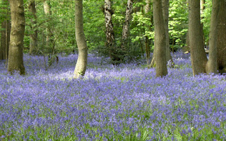
CIMG6359
Wood anemones, Selsdon Wood
May-13 • Sean O'Neill
banner, swcwalk43, swcwalks 5874925966284104626 P

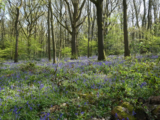
CIMG7299
St Mary the Virgin Church, Farleigh
Mar-15 • Sean O'Neill
swcwalk43, swcwalks, walkicon 6133825314030050498 P

CIMG7898
Wood sorrel (violet flowers), Ledgers Wood
Apr-15 • Sean O'Neill
swcwalk43, swcwalks, walkicon 6140189880647878994 P


CIMG4210
Copper beech leaves, Selsdon Wood
May-16 • Sean O'Neill
swcwalk43, swcwalks, walkicon 6397053872749497890 P
| Length |
Main Walk: 17 km† (10.6 miles). Four hours walking time. For the whole excursion including trains, sights and meals, allow at least 7½ hours. Short Walk, omitting Selsdon Wood: 13½ km† (8.4 miles). Three hours 10 minutes walking time. Alternative Walk, finishing at Woldingham: 14¾ km (9.2 miles). Three hours 30 minutes walking time. Short Alternative Walk, omitting Selsdon Wood: 11¼ km (7.0 miles). Two hours 40 minutes walking time. † Add 3 km (1.8 miles; 40 minutes) if extending the walk via Greatpark. See Walk Options below. |
|---|---|
| OS Maps |
Explorers 146 & 161. Upper Warlingham station, map reference TQ338585, is on the London / Surrey border, 8 km S of Croydon. |
| Toughness |
4 out of 10 (3 for the Short and Alternative Walks). |
| Features |
Although only a few miles from Croydon and well inside the M25, this part of London's border with Surrey feels anything but urban. Away from the main roads you are soon in woods, fields and isolated valleys which escaped the post-war expansion of south London's suburbs. Now part of the Green Belt, the area is protected from large-scale development and remains a rural haven, with plenty of fine bluebell woods to admire in April and May. The walk starts with a climb to the top of Riddlesdown and the adjoining Sanderstead to Whyteleafe Countryside Area, which since July 2019 have been part of a new South London Downs National Nature Reserve. It then heads east via Hamsey Green for a short stretch through King's Wood, the best of the bluebell woods. After crossing an isolated valley the full walk continues with a meandering excursion through Selsdon Wood Nature Reserve, which also has good displays of wood anemones. A tiny 11thC church and more bluebell woods are then passed on the way to a lunch pub on the edge of Great Farleigh Green. The return leg takes a different path back across the valley to King's Wood and this time goes through its full length. The walk ends with a longer stretch through the designated Countryside Area, with a flight of steps taking you down to a park café in Whyteleafe Recreation Ground and a choice of return stations. |
| Walk Options |
The Short Walk saves 3½ km by taking a direct route to Farleigh church, omitting the morning loop through Selsdon Wood. Conversely, you can extend both the Main and Short Walks with a loop around the Greatpark estate, an extra 3 km. These Extended Circular Walks take in another small nature reserve, Ledgers Wood. The original version of this walk finished at Woldingham station and its ending down the side of Halliloo valley has been retained in the two Alternative Walks, with and without the morning loop through Selsdon Wood. As you might expect for a walk near the London boundary, there are several places where you could cut the walk short by catching a bus (see Transport below). |
| Additional Notes |
This walk has been much altered over time, in response to changes in access to the area's nature reserves and the availability of suitable refreshment places. As noted above an earlier version finished at Woldingham station, originally with a longer afternoon through Woldingham Garden Village (now incorporated in the Kenley to Caterham walk, #406), but this was not well suited to the rather early closing time of Woldingham's only tea place (especially in winter and on Sundays). A circular walk returning to Whyteleafe was always the most convenient option for transport reasons, and the opening of its Pavilion Café in 2019 has allowed this even older variation to be restored as the Main Walk, with some adjustments to reduce its overlap with the Whyteleafe to Hayes walk (#38). In 2023 the route was tweaked again to simplify a confusing set of options which had been introduced in response to a request for a mid-afternoon refreshment break at Farleigh church. This made the Main Walk too unbalanced but you could do the Short Alternative Walk as an afternoon walk, with the church as a midway refreshment stop (see Lunch below). |
| Transport |
The most convenient starting point for this walk is the rather misleadingly named Upper Warlingham station (see Walk Notes), which is close to Whyteleafe station in the valley below Warlingham. The stations are on different lines but both go through East Croydon. Upper Warlingham has a half-hourly service from Victoria, taking 31 minutes; Whyteleafe has a half-hourly service from London Bridge, taking 35 minutes. Both stations are in TfL Zone 6 so a Travelcard or London Freedom Pass are sufficient for the Circular Walks. However, these options (and Oyster PAYG) are not valid at Woldingham. For the Alternative Walks a return to Woldingham is valid to both Upper Warlingham and Whyteleafe on the way out; if you have a Travelcard or pass, buy a single from Woldingham to Upper Warlingham on the way back. If driving, Upper Warlingham and Whyteleafe have large station car parks which cost around £7-8 Mon–Sat (except that Whyteleafe is only £4 on Saturday); both are around £2.50 Sun & BH (2024). There are two useful bus routes in the area. London bus 403 runs every 12-20 minutes from the Sainsbury's on Limpsfield Road through Warlingham and Hamsey Green to Croydon; Metrobus 409 (not TfL) runs hourly from Selsdon via Old Farleigh Road and Chelsham (near both lunch places) down to the stations in Whyteleafe. |
| Suggested Train |
Take the train nearest to 09:50 from Victoria to Upper Warlingham, or 10:20 for the Short Walks. If you want to do the Short Alternative Walk as an afternoon walk with just a tea stop, take the train nearest to 11:50. |
| Train Times |
|
| Timetables |
|
| Lunch |
If you are not doing the Greatpark extension the lunch pub on the Circular Walks is The Harrow (01883-627565) on Great Farleigh Green, after around 11 km if you do the longest of the suggested routes through Selsdon Wood (7¼ km on the Short Walk). Part of the Vintage Inns chain, this is a large and popular pub / restaurant with a wide range of food options and plenty of outdoor seating, but is on a fairly busy road. The Bull Inn (01883-627735) on Chelsham Common is more conveniently placed on both the Extended Circular Walks and the Alternative Walks, at about the same distance as The Harrow. It serves typical pub food and has a beer garden overlooking the common. For added flexibility directions are given for detours to The Harrow on these options, both before and after the Greatpark loop on the Extended Walks. The suggested place for a picnic lunch is at Farleigh church, which has several benches in its churchyard. Mid-walk refreshments (tea and home-made cakes) might also be available in the village hall behind the church on summer Sundays. |
| Tea |
At the end of the circular walks the suggested place in Whyteleafe is the small Pavilion Café (01883-770666; open daily to around 4pm) in the Recreation Ground, a friendly place serving hot drinks and a selection of cakes. On the A22 between its two stations stronger fare is available at the refurbished Whyteleafe Tavern (01883-624547) and the Radius Arms micro-pub (07514-916172). Neither pub does hot drinks but you could get these next to the Radius Arms at Dzerts (01883-212344), which mainly does take-away desserts but has a few tables for customers. In the same parade of shops there is also a Village Bakery and the Whyteleafe Café, but both are likely to be closed at the end of a walk. If you get there in time a good tea place on the Woldingham ending (ten minutes before the station) is The Dene (01883-653142; open to 4.30pm Mon–Sat, 4pm Sun), “an eating place for tea lovers” in Knights Garden Centre. |
| Profile | |
|---|---|
| Help Us! |
After the walk, please leave a comment, it really helps. Thanks! You can also upload photos to the SWC Group on Flickr (upload your photos) and videos to Youtube. This walk's tags are: |
| By Train |
Out (not a train station) Back (not a train station) |
| By Car |
Start CR3 0EP Map Directions |
| Amazon | |
| Help |
National Rail: 03457 48 49 50 • Traveline (bus times): 0871 200 22 33 (12p/min) • TFL (London) : 0343 222 1234 |
| Version |
Apr-24 Sean |
| Copyright | © Saturday Walkers Club. All Rights Reserved. No commercial use. No copying. No derivatives. Free with attribution for one time non-commercial use only. www.walkingclub.org.uk/site/license.shtml |

Walk Directions
Click the heading below to show/hide the walk route for the selected option(s).


 Walk Map
©
Walk Options ( Circ. | Alt. )
Click on any option to show only the sections making up that route, or the heading above to show all sections.
- Main Walk (17 km)
Walk Directions
Click on any section heading to switch between detailed directions and an outline, or the heading above to switch all sections.
- Upper Warlingham • Whyteleafe Station to Tithepit Shaw Lane (2¼ km)
- From either Upper Warlingham or Whyteleafe station, head for the Recreation Ground in Hillbury Road. Go to its top left-hand corner and take a path going uphill, parallel to the railway. At the top turn right in front of Riddlesdown Quarry onto a path leading up to Riddlesdown. Take any of the grassy paths heading roughly east across this open space to come out onto Tithepit Shaw Lane at a sharp bend.
-
Starting from Upper? Warlingham Station
- Arriving from London, go up the steps in the middle of the platform and turn right on the footbridge to come out onto Westhall Road. Turn left, go down to the bottom of the hill and turn right into Hillbury Road. In 80m turn left into Whyteleafe Recreation Ground.
-
Starting from Whyteleafe Station
- Leave the station by a path at the front of the platform and turn sharp left. Go across the roundabout on the A22 (there is a pedestrian crossing off to the left), up the B270 (Hillbury Road) and under the railway bridge. In 100m turn left into Whyteleafe Recreation Ground.
- Go through the small car park, which has an information panel about the Sanderstead to Whyteleafe Countryside Area?, and take the tarmac path to the right of a toilet block. This goes straight ahead for 150m and then turns half-left to head for a bridge under the railway line, near the bottom of a long flight of steps up the steep bank ahead (which is the return route).
-
Just before reaching the bridge, bear right onto a grassy path heading N, parallel to the railway and climbing steadily for 500m, later through woodland. At the end turn right at a T-junction in front of metal railings guarding the disused Riddlesdown Quarry?, with a belt of trees on your right.
- If the narrow path alongside the railings is too awkward you could go through a gap in the trees to walk along the field edge parallel to it.
- At the top go through a wooden kissing gate and turn half-left onto Riddlesdown? to continue with a hedge on your right. At the end keep ahead through a gap and cross over a stony path. Go up to a hedge and bear right to continue alongside it, heading ENE.
- In 150m keep ahead at a path crossing, now with a copse on your left (Dipsley's Shaw). In a further 250m turn half-right at the next path crossing onto a grassy path heading SE towards a corner of the open space. Go out through a small parking area and bear left onto a road (Tithepit Shaw Lane) at a sharp bend.
- Tithepit Shaw Lane to Farleigh Golf Club (2¾ km)
- Head east along the road, on the London Outer Orbital Path (LOOP). Cross over the B269 (Limpsfield Road) and continue in the same direction along Kingswood Lane. At the end of this long residential street turn left into King's Wood. Cut through its eastern end (briefly leaving the LOOP) and return to Kingswood Lane. Turn left briefly onto this lane, then take a footpath on the right through Mossyhill Shaw and past Elm Farm to Old Farleigh Road. Turn left and take a permissive path alongside the road to the entrance to Farleigh Golf Club.
- Go along the road for 400m, now on the London Outer Orbital Path? (LOOP). At the end cross the B269 (Limpsfield Road) carefully; behind the railings opposite there is an information panel about the long history of Hamsey Green Pond?.
-
There is 500m more road walking: go all the way along the tree-lined Kingswood Lane, starting to the right of the pond. Immediately after the last house turn left onto a track, briefly leaving the LOOP. Follow the track past some paddocks into King's Wood?, initially with a fenced-off enclosure on your right.
This section only makes a brief incursion into this large Open Access wood, which is particularly colourful in spring. In the bluebell season you might be tempted to explore it further, but note that the return leg of the Circular Walk goes through its full length.
- In 150m turn right at the corner of the enclosure to continue alongside it, now heading NE. As noted above you could detour off to the left, but for the most direct route carry on in this direction near the dilapidated fence for 250m to come to the end of a broad grassy avenue stretching off to the left. Veer right onto a narrow path which leads out to an unsurfaced track, the continuation of Kingswood Lane.
-
Turn left briefly onto the track, rejoining the LOOP and heading N. In 75m turn right onto a signposted footpath, through a metal kissing gate and along the edge of a large field. In the next corner go through a gap into Mossyhill Shaw and follow a path downhill through the wood, curving round to the right at the bottom of the valley.
You might be able to see the top of Selsdon Park Hotel? above the trees to the left, 1½ km away.
- The path winds its way up the other side of the valley, briefly merging with a farm track from the right near the top. In 250m you come out onto a grassy strip in front of Old Farleigh Road. Cross the road carefully (traffic is quite fast) and turn left to go alongside the road.
- Soon there is a tall hedge on your left which shields this permissive horse ride from the road. In 300m the path comes to the access road to Farleigh Golf Club, with a bridleway straight ahead and a signposted footpath off to the right alongside the driveway.
- Farleigh Golf Club to Selsdon Wood (exit) (2½ • 1½ • 1¼ km)
-
 Go across the golf club's access road onto a bridleway (Baker Boy Lane), joining the Vanguard Way (VGW). This comes to a fork at the entrance to Puplet Wood. The rather convoluted main route explores the northern part of Selsdon Wood and comes out at its eastern corner, but for variety you could take a shorter route through Puplet Wood or simply stay on Baker Boy Lane.
- Go straight across the golf club's access road onto a signposted public bridleway (Baker Boy Lane), joining the Vanguard Way? (VGW). In 200m this tree-lined path bends right and starts to go gently downhill. In a further 100m you come to a fork at the entrance to Puplet Wood.
-
Main route, via Selsdon Wood (up to 2½ km)
- Fork left to stay on the waymarked routes, going gently downhill. In 250m you come to a path crossing with a tall wooden kissing gate across a dip on your left.
-
Turn left to cross the dip and go through (or around) Baker Boy Lane Gate into Selsdon Wood?, leaving the VGW & LOOP.
Selsdon Wood is a pleasant place to explore and you could devise your own route from the map. You would need to leave the wood at its easternmost corner, just over 500m away at the bottom of the hill; any path going downhill in roughly the right direction leads to this exit. On the mazy route described below you can sometimes confirm your position at junctions by looking for the path names on wooden plaques high up in the trees.
- Inside the wood turn left onto the perimeter path (East Gorse). In 125m ignore a path on the right (Middle Gorse) but 25m later turn right into West Gorse.
- In 150m there is a memorial cairn and a small pond on your right (Linden Glade). Veer right at the path junction here, then immediately turn left into Smith Grove.
- In 125m turn right at a path crossing (into Bluebell Grove) and follow this for 250m, ignoring ways off. At the end turn left at a T-junction onto a broad path (Leafy Grove).
-
In 125m turn left at a major path junction (with Langfords Way, Stevens Walk and Court Wood Grove).
- For a short cut (saving 700m) you could turn right onto Langfords Way instead; this merges with the main route just before the exit from Selsdon Wood.
- Go out through a gap and along the right-hand side of an open area (Great Field), parallel with Langfords Way inside the wood. In 150m, shortly before the field narrows, veer right back into the trees.
- Bear right across Langfords Way onto a broad path (Avis Grove) into the northern part of the wood. In 150m keep ahead at a path crossing (with Beech Grove).
- In a further 200m turn right at the next path crossing (with Addington Border), rejoining the VGW & LOOP but now in the opposite direction.
- Follow this waymarked path for 500m to the exit, crossing over Court Wood Grove after 200m and merging with Langfords Way after another 200m.
-
Leave the wood through Court Wood Lane Gate and keep ahead on a signposted bridleway, leaving the VGW & LOOP which turn right into Baker Boy Lane.
-
Alternative route, via Puplet Wood (1½ km)
- Fork right onto a bridleway, leaving the waymarked routes. The simplest route is to follow it all the way through the wood, but if it becomes too muddy there is a narrow path branching off to the right which you can take, staying near the edge of the wood.
- This alternative path rejoins the bridleway as it curves round to the left (almost doubling back) near the far end of the wood. It then swings right to return to Baker Boy Lane, where you turn right for the final 250m.
- Just before Baker Boy Lane leads into a residential street turn right onto a signposted bridleway, leaving the VGW & LOOP which turn left into Selsdon Wood.
-
Direct route, on Baker Boy Lane (1¼ km)
- …
- Ignore this gate and carry on downhill for a further 500m, between Selsdon Wood and Puplet Wood.
- …
- Selsdon Wood to Farleigh Church (2¼ km)
- Take the bridleway heading east from the corner of Selsdon Wood, later going around (or just inside) Frith Wood. Turn right and head south on an enclosed bridleway through the golf course. Go across Farleigh Court Road onto Church Road (rejoining the VGW) to reach the church.
-
Head E on the chalky bridleway, climbing steadily away from Selsdon Wood with the golf course behind a hedge on your right. At the top follow the path round to the right, ignoring a narrow path into Frith Wood on your left. The simplest route is to continue along the bridleway just outside the wood.
- A little further on there are some gaps in the trees which would let you switch to a narrow path just inside the wood, which meanders around a few obstacles without straying too far from the bridleway.
- After heading S for 350m the bridleway turns left at the corner of the wood and continues just inside it. In a further 350m you come to a T-junction and turn right onto another bridleway; the woodland path mentioned above meets this bridleway just off to the left.
- Simply follow this enclosed bridleway S for just over 1 km, with the golf course on both sides. At the end go straight across Farleigh Court Road onto Church Road, rejoining the VGW.
- Go along this cul-de-sac past stables and cottages to a parking area for the church of St Mary the Virgin?. This attractive little church is usually locked, but is open on summer Sunday afternoons when tea and home-made cakes are available in the hall.
- Farleigh Golf Club to Farleigh Church direct (1¼ km)
- Turn right onto a footpath, leaving the LOOP and joining the Vanguard Way (VGW). Follow it alongside the golf club's access road, through a wood and round to the right. At the end turn left onto Farleigh Court Road, then in 150m turn right into Church Road to reach the church.
-
Turn right onto the footpath, leaving the LOOP but with a VGW waymarker indicating that you have joined the Vanguard Way?. This narrow path can be waterlogged and you might find it easier to walk along the adjacent grass verge for 150m. Where the path splits fork right to follow the waymarked footpath into a wood.
The left fork is a permissive horse ride which stays closer to the golf club's access road; the two routes rejoin in 500m.
- The woodland path goes gently downhill across a dip and back up the other side. On leaving the wood it swings round to the right, parallel to a roadway on the left. At the end the path goes through a belt of trees and comes out onto a lane (Farleigh Court Road). Turn left onto the lane, then in 150m turn right into Church Road.
- …
- Farleigh Church to Chelsham Common (1¼ • 2¼ km)
-
Go through the parking area onto a bridleway. Unless you want to visit The Harrow, follow the VGW alongside Greatpark Wood to a five-way path junction.
- To detour to the pub, … To rejoin the main route, return to the bridleway and go along it for 500m to the five-way path junction.
-
Main route (1¼ km)
- … ignore a kissing gate on the right and carry on along the bridleway, staying on the VGW.
- The bridleway goes gently downhill alongside the wood, eventually curving round to the right and coming to a path junction with a five-way footpath signpost.
-
Route via The Harrow (2¼ km)
- …
- …
- …
- From the pub retrace your steps back across Old Farleigh Road and along the fenced bridleway. Ignore all paths into Littlepark Wood (including your outward route) and follow the bridleway for 300m to a small clearing, with a cul-de-sac on the right (Daniels Lane).
- Go straight across the clearing, passing a white-painted Coal Tax post? in the undergrowth on the left. The tree-lined bridleway goes gently downhill and in 200m comes to a path junction with a five-way footpath signpost.
- From the five-way junction take the signposted footpath heading SE, with a VGW waymarker. Go past wooden barriers and follow the enclosed path along the western edge of the Greatpark estate. After a couple of bends the path comes out past more barriers onto its access road.
- Turn right and go along the road for 60m. Just before reaching a crossroads, veer left by a bus stop onto a short path cutting off the corner. Go straight across Ledgers Road and take the short cul-de-sac opposite. Follow it past some cottages into the car park for The Bull Inn, a possible lunch stop on the edge of Chelsham Common.
- Chelsham Common to Greatpark Wood (2½ km)
- Go to the eastern corner of the common and continue briefly on Church Lane, leaving the VGW. Turn left onto a footpath but instead of following it through Holt Wood, take a permissive path through Ledgers Wood. On the far side turn right onto a footpath alongside the southern edge of the Greatpark estate. Follow footpaths around the estate to come back along its northern side, returning to the five-way path junction at the corner of the estate.
- Go past a vehicle barrier at the end of the pub's car park and follow a grassy path curving round to the left, heading E parallel to a lane on the right. Where the path forks in front of a tree-lined pond you can take either route around it to reach a crossroads just beyond the far side.
- At the crossroads leave the VGW by heading E briefly on Church Lane, signposted as Cycle Route 21 (towards Greenwich). After passing a few houses turn left past a vehicle barrier onto a signposted footpath, along a driveway leading to a block of garages.
- Go through a gap to the right of the garages to come to a Surrey Wildlife Trust sign for Ledgers Wood?. Ignore a stile on the right (the continuation of the footpath) and take the right-hand of two paths ahead into this open-access wood.
-
In 50m you come to a path crossing where the suggested route is to turn right and follow a clear path which will curve gradually round to the left, staying fairly close to the edge of the wood.
- The path going straight ahead at the path crossing is an equally pleasant route, curving round to the right and eventually meeting the perimeter path at a T-junction where you would turn left. Avoid paths off to the left which lead into the ‘wrong’ part of the wood, where there is no convenient exit.
- After the perimeter path curves left there is a dilapidated wire fence on the right marking the boundary with the rather gloomy Holt Wood. The path curves left again and goes through a slightly scruffy area before coming out past another Ledgers Wood sign onto a small grassy area in front of a belt of trees.
- Turn right to go alongside these trees. At the end veer left through a gap to join a public footpath on the other side, going through a vehicle barrier and heading NE between the private Greatpark estate and the conifers of Holt Wood.
- In 200m fork left to stay alongside the estate's patch of private woodland. In a further 200m, shortly before the end of the field on your right, turn left at a path junction with yellow waymarkers on a post. Follow this woodland path past a redundant stile and keep left to stay fairly close to the estate's boundary fence.
- In 250m the footpath swings left to go back down the other side of the estate, with Greatpark Wood on the right. Opposite the estate's prominent Clock Tower? you pass a locked metal gate into the wood, with a plaque listing the previous uses of the site.
- The path eventually curves right and goes past a wooden vehicle barrier to a T-junction with a bridleway. Turn left to return to the five-way junction at the start of the Greatpark loop.
- Greatpark Wood to Old Farleigh Road (¾ • 1 km)
-
Unless you want to (re)visit The Harrow, take the footpath heading north-west across the corner of a large field to Littlepark Wood. Continue on a path just inside the wood (or along the edge of the field) to the far end. Follow the path round to the left and across Great Farleigh Green. Cross Old Farleigh Road onto a bridleway.
- To detour to the pub, take the bridleway heading west to reach the pub on Old Farleigh Road. To rejoin the main route, …
-
Main route (¾ km)
- From the five-way junction take the signposted footpath heading NW, through a gap in the tree boundary into a large field. Follow a grassy path across it, gradually approaching Littlepark Wood.
- At the edge of the wood the right of way continues along the field edge, but the suggested route is to enter the wood and turn right onto a meandering path near its edge, passing the occasional “Walkers Welcome” sign.
- At the far end the woodland path curves up to the left, climbing gently and merging with more paths coming in from the field. Go past a redundant stile onto the edge of Great Farleigh Green, with Old Farleigh Road on the far side of the common.
- Keep right initially on a mown path and then fork left where it splits. The path comes to a T-junction with another mown path where you go straight ahead on a faint grassy path, heading directly towards a bridleway signpost on the other side of the road, 75m away.
- As you approach Old Farleigh Road your path merges with a bridleway coming in from the left. Go straight across a horse ride …
-
Route via The Harrow (1 km)
- From the five-way junction take the signposted bridleway heading W. In 200m this tree-lined path passes a white-painted Coal Tax post? in the undergrowth on the right and comes to a small clearing by the corner of Littlepark Wood, with a cul-de-sac on the left (Daniels Lane).
- Go straight across the clearing onto the continuation of the bridleway, …
- …
- …
- Farleigh Church to Old Farleigh Road via The Harrow (1½ km)
- Go through the parking area onto a bridleway and take a footpath on the right after 150m, leaving the VGW. Go down across a large field and follow the footpath through Littlepark Wood. Turn right onto a bridleway on its southern edge to come to The Harrow at the junction of Old Farleigh Road with Harrow Road. From the pub take a permissive horse ride heading north along Great Farleigh Green for 300m, then go back across the road onto a bridleway.
- Take the bridleway on the far side of the parking area. In 150m, at the corner of Greatpark Wood, turn right through a wooden kissing gate onto a public footpath going down across a large field, leaving the VGW. On the far side go through a gap in the trees into Littlepark Wood.
-
Keep ahead at a path crossing just inside the wood and follow the footpath up through the trees, curving slightly to the left. In 150m you come to a major path junction, with a bridleway off to both sides. Go straight across this and take either of the two paths ahead.
The left-hand path is the continuation of the public footpath but both paths lead to a T-junction with another bridleway on the edge of the wood.
- On the far side of the wood turn right onto the bridleway, with garden fences on your left. This potentially muddy path comes out onto Old Farleigh Road by a mini-roundabout with Harrow Road, with The Harrow inn on the far side of the main road.
- From the pub retrace your steps across Old Farleigh Road. Go past the bridleway from Littlepark Wood and take a footpath (which is also a permissive horse ride) onto the southern end of Great Farleigh Green.
- Follow the horse ride for 300m, parallel to the main road and crossing a couple of private driveways. At an oblique junction with a bridleway coming in from the right, veer left and cross the road carefully onto the signposted continuation of this bridleway.
- Old Farleigh Road to Limpsfield Road (3 km)
-
 Head west on the bridleway for 800m, then turn right onto a short footpath leading to Kingswood Lane. Turn right briefly onto the lane and then turn left into King's Wood, briefly retracing a short part of your outward route. Take any route through the wood to its north-western corner. Go along Lime Meadow Avenue and Sanderstead Court Road to the B269 (Limpsfield Road).
- The bridleway soon becomes an enclosed path between a hedge and a belt of trees, with large fields off to the left. Later it starts to descend and after 500m you are going across an open valley, then climbing quite steeply up the other side. At the top of the slope the bridleway continues alongside a wood (Moseshill Shaw) for 300m.
- At the end of the wood there is a fieldgate ahead on your right, leading into a square field. Turn right off the bridleway onto a narrow footpath between the wood and this field. The path leads out past wooden barriers onto an unsurfaced lane. Turn right and go along it for 200m, passing paddocks on your left and Kingswood Lodge on the right.
-
At the end of the paddocks turn left onto an unmarked path into King's Wood, briefly retracing a small part of your outward route. The path leads into a broad grassy avenue and the simplest route is to go all the way along it, almost 1 km.
- In the bluebell season you might be tempted to take one of the paths off to the left of the main avenue and zig-zag through the wood. There is a parallel avenue 200m away with several broad connecting tracks between them, plus many smaller paths meandering through the wood.
- If you stay on the broad avenue follow it round to the left on the far side of the wood, with an open space and later a large sports ground beyond the trees on your right. The path eventually comes to the north-western corner of the wood where a short path on the right leads out to a residential street (Lime Meadow Avenue).
-
Turn left onto the tree-lined street, away from the entrance to the sports ground. At the bottom of a slope veer right and left to go up another residential street (Sanderstead Court Avenue) to the B269 (Limpsfield Road).
Buses go to Croydon from a stop across the road if you want to curtail the walk.
- Limpsfield Road to Upper Warlingham • Whyteleafe Station (2¾ km)
- Cross the main road and take a footpath past a primary school into a corner of the Sanderstead to Whyteleafe Countryside Area. Take any route across it to its south-western corner. Go down a flight of steps into Whyteleafe Recreation Ground, which has a café. To complete the walk go out through its car park and turn right onto the B270 (Hillbury Road). Turn left for Upper Warlingham station or go across the A22 for Whyteleafe station.
- Cross the road at the pedestrian lights and take the signposted footpath to the left of the entrance to a primary school. This narrow fenced path goes alongside its driveway and turns left to continue past its small playing field. At the corner of the chainlink fence leave the main path which turns right, instead turning half-right onto a faint grassy path through a lightly-wooded area.
- In 250m go through a wooden kissing gate into the corner of a large meadow, with an information panel for the Sanderstead to Whyteleafe Countryside Area. Take the broad grassy path going diagonally across the meadow, heading SW. In the far corner go through a gap in the hedge and turn right to go along the edge of the next meadow, alongside a wood (Ansley Berry Shaw).
- In the next corner go through a gap in the trees and turn left along the edge of a third meadow. Towards the far side bear slightly right to go through a gap in the trees into a large open space. Take the left-hand of two grassy paths ahead, heading S and crossing over your outward route. In 100m go straight across a stony path carrying the LOOP and carry on alongside a wire fence for 400m.
- At the corner of the fence turn half-right onto a faint grassy path, gradually approaching the woodland ahead which is at the top of a steep slope. There are several ways down through this bank of trees into Whyteleafe Recreation Ground, but by far the easiest is a path through a gap at the right-hand end of these trees, which leads to the top of a long flight of steps.
- Towards the bottom of these steps you can veer left across the grass, passing the end of a children's play area. Make your way onto the tarmac path leading to the small car park on the far side of the Recreation Ground (where you came in at the start of the walk). The suggested refreshment stop is the Pavilion Café in the low building off to the left of this path.
-
To complete the walk leave the Recreation Ground through the car park. Turn right onto the B270 (Hillbury Road) and go under the railway bridge.
- To go directly to Upper Warlingham station, turn left at the mini-roundabout and go all the way up Station Approach. If the ticket hall is locked, there is a gap onto Platform 1 (for trains to London) by the car park ticket machines.
- For other refreshment options, or the alternative station on the Caterham line, carry on down Hillbury Road and turn left onto the A22 at the large roundabout. The Whyteleafe Tavern is on the other side of the road here; the Radius Arms, Dzerts and the Whyteleafe Café are in the parade of shops ahead on the left-hand side (although the café will probably have closed).
-
Finishing at Upper Warlingham Station
- Carry on along the A22 and turn left into Station Road to come to the station at the top. …
-
Finishing at Whyteleafe Station
- Either take the alleyway from the pedestrian lights by the shops or go down the road from the roundabout. If the level crossing is down, you can reach Platform 1 (for trains to London) via the footbridge from Platform 2.
- Chelsham Common to Woldingham Station (3¾ km)
- Go to the south-western corner of the common and continue briefly on Chelsham Road. Turn left onto a bridleway going through a wood, past Chelsham Place Farm and across Limpsfield Road into High Lane. Turn right to go downhill on Plantation Lane, above a golf course in Halliloo valley. Follow the bridleway round to the left past the clubhouse, then turn right onto a horse ride running alongside Halliloo Valley Road. Turn left into Park Ley Road and go down a track to head south on Woldingham Road. For the Dene Coffee Shop, detour along the driveway to Woldingham Dene before continuing along the road to the station.
- From the corner of the pub's car park leave the VGW by taking a broad grassy path heading SW across the triangular common towards a point where two lanes meet, 125m away. Continue in the same direction along Chelsham Road, joining Cycle Route 21 (which you will be following to Woldingham Road). In 100m turn left onto a bridleway into a wood.
-
After passing Cherry Tree Cottage ignore a footpath off to the left to stay on the bridleway, near the edge of the wood. At the far end of the wood the bridleway continues alongside Greenlawn Memorial Park and later passes Chelsham Place Farm before reaching the B269 (Limpsfield Road).
Buses to Croydon start from the other side of the roundabout off to the right if you want to curtail the walk.
- Cross this main road carefully and continue on High Lane opposite, following it round to the left and gently downhill. 200m from the main road, turn right into Plantation Lane. This bridleway descends gently, with views of the golf course in Halliloo valley through the hedge on your left.
- In 800m the path curves to the left and begins to descend more steeply. Ignore a stile on the left and a couple of footpaths on the right to continue down past the clubhouse. Just before reaching Halliloo Valley Road, turn right onto a horse ride running parallel to it.
-
In 300m veer left through a gap in the hedge and cross this road carefully into Park Ley Road opposite (not the bridleway up to its left). In 30m bear right downhill on a track, following the CR 21 sign. At the bottom turn left onto Woldingham Road to come to the entrance to Woldingham Dene in 150m.
- For a possible tea place turn left into this driveway, which curves round to the left. The Dene Coffee Shop is in the conservatory of the house at the end of the drive. Afterwards you could return to Woldingham Road via a pergola and the garden centre, but it is simpler to retrace your steps along the drive.
- To complete the walk continue along Woldingham Road for 500m, passing the main entrance to Knights Garden Centre and a side road (Long Hill) on the left. The entrance to Woldingham station is on the other side of the main road where it turns sharply left uphill at its junction with Church Road. Cross the footbridge to Platform 1 for trains to London.
- The station on the Oxted line was named ‘Upper’ Warlingham when it opened in 1884 to distinguish it from another Warlingham station, lower down the valley on the Caterham line. It retained the unnecessary prefix when the other station was renamed Whyteleafe South in 1956.
- The Sanderstead to Whyteleafe Countryside Area is jointly owned by Croydon and Tandridge Councils and the Whitgift Foundation. The three owners are working with Natural England to restore the 200 acres of chalk downland under the Countryside Stewardship Scheme.
- Chalk was mined at Riddlesdown Quarry from the late 18thC to 1967, and burnt in kilns to produce lime. The site was bought by the City of London Corporation in 1996 and is part of Riddlesdown's Site of Special Scientific Interest.
- Riddlesdown is owned and managed by the City of London Corporation. It is one of the seven “City Commons” in Surrey and south London which were purchased in the 1880s to preserve the area as open countryside for Londoners.
- The London Outer Orbital Path – the ‘M25 for walkers’ – runs for 240 km around outer London, from Erith in Kent to Purfleet in Essex.
- Hamsey Green Pond would have been a watering hole for cattle on route to market when this area was farmland. Like many such ponds it dried up when the land was used for housing, but has been restored by the local council.
- King's Wood (sometimes spelt Kings or Kings') was purchased by Croydon Corporation in 1937 as public open space. The wood had originally been laid out for pheasant shooting, with broad rides dissecting the woodland in a regular grid pattern. It is carpeted with bluebells in spring.
- In the late 1960s the Conservative Party held conferences at the Selsdon Park Hotel to decide its economic policy. The Labour Prime Minister, Harold Wilson, derided Edward Heath as ‘Selsdon Man’ but the Conservative leader had the last laugh, winning the 1970 general election.
- The Vanguard Way runs for 105 km “from the suburbs to the sea”, from Croydon in south London to Newhaven in East Sussex.
- Selsdon Wood Nature Reserve was established after a local campaign to prevent development raised funds to purchase the 200 acre site. The land was donated to the National Trust in 1936 and is managed on their behalf by Croydon Council.
- St Mary the Virgin, Farleigh is a simple little church with an open bell turret. It dates from the late 11thC, with the porch being added in the 16thC.
- Cast-iron Coal Tax posts were erected in the 1860s to mark a taxation boundary. A levy on coal had been brought in to help pay for the rebuilding of London after the Great Fire of 1666, and with the growth of road and rail transport it was no longer practicable to collect it in the Port of London.
- Ledgers Wood is a small woodland reserve managed by the Surrey Wildlife Trust, with a fine display of bluebells in spring (plus some rare wood sorrel with violet flowers).
- The Clock Tower was the water tower for Warlingham Park Hospital (formerly Croydon Mental Hospital) before the site was redeveloped as the Greatpark estate. The psychiatric hospital was a pioneering centre for psychosurgery, the now discredited treatment of mental disorder by the destruction of brain tissue.
The most convenient station for this walk is Upper Warlingham, but Whyteleafe station is very close.
If you are doing a Short Walk (omitting Selsdon Wood), go to §E.
There is a choice of routes for the rest of this section. The main route goes through the eastern part of Selsdon Wood (ahead on your left), which has extensive patches of wood anemones in early spring as well as good displays of bluebells. The alternative route in [?] goes through Puplet Wood (also good for bluebells, but can be muddy in wet weather). The direct route in [?] simply remains on the bridleway running between the two woods.
If you are doing the Main Walk without the Greatpark extension, go to §I; otherwise, go to §F.
If you are doing the Short Walk without the Greatpark extension, go to §I.
The main route for this section goes directly to The Bull Inn. If you want to visit The Harrow instead, take the alternative route in [?].
If you are doing an Alternative Walk (to Woldingham), go to §L.
If you want to (re)visit The Harrow, take the alternative route in [?].
Continue the directions at §J.
Walk Notes
» Last updated: April 26, 2024
Return to Top | Walk Map | Walk Options | Walk Directions.