Salisbury to Amesbury via Old Sarum and Stonehenge walk
Up the Avon Valley from the attractive marker town of Salisbury past Old Sarum hillfort and castle site to the Stonehenge World Heritage Site and on to historic Amesbury

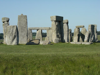
Stonehenge from footpath along northerly side
SWC 67 Salisbury to Amesbury (via Stonehenge)
Jun-16 • thomasgrabow on Flickr
swcwalks swcwalk67 banner walkicon 27844251275

Salisbury Cathedral
SWC 67 Salisbury to Amesbury (via Stonehenge)
Jun-16 • thomasgrabow on Flickr
walkicon swcwalks swcwalk67 27844286115

Woodhenge
SWC 67 Salisbury to Amesbury (via Stonehenge) Extension to Woodhenge and Durrington Walls
Jun-16 • thomasgrabow on Flickr
walkicon swcwalks swcwalk67 27232173143
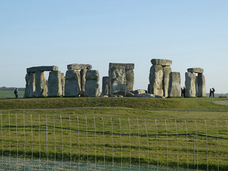
Stonehenge
Salisbury to Amesbury via Stonehenge walk
Mar-22 • Saturdaywalker on Flickr
swcwalks swcwalk67 banner 51986916213
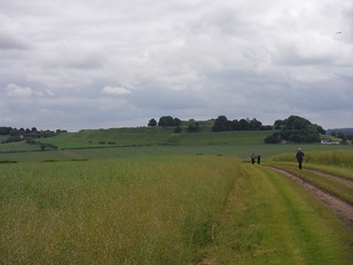
Old Sarum from bridleway to the North
SWC 67 Salisbury to Amesbury (via Stonehenge)
Jun-16 • thomasgrabow on Flickr
walkicon swcwalks swcwalk67 27844271445
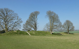
Old Sarum trees
Salisbury to Amesbury via Stonehenge walk
Mar-22 • Saturdaywalker on Flickr
swcwalks swcwalk67 walkicon 51985847307
| Length |
26.0 km (16.1 mi), with 288/268m ascent/descent. For a longer or shorter walk, see below Walk Options. |
|---|---|
| Toughness |
5 out of 10, with 6 hours walking time. For the whole outing, including trains, sights and meals, allow at least 10 ½ hours. |
| Walk Notes |
This walk mostly follows the Avon Valley upstream from the quintessentially English Cathedral City of Salisbury with its many historic buildings, to Amesbury which claims to be the oldest occupied settlement in Great Britain, having been first settled around 8820 BCE. En route you rise out of the valley to the site of Salisbury’s earlier incarnation: Old Sarum, with its impressive hilltop location, banks and ditches, ruined remains of an earlier cathedral and supreme views across the Avon Valley and to the modern town.
You then bear away from the Avon Valley to enter the very evocative Stonehenge World Heritage Site with its numerous pre-historic monuments: barrow cemeteries, large linear or non-linear earthworks and wooden and stone henges. All but two of the fifteen most prominent monuments in the Stonehenge area, as well as many more minor sites, are either passed on, or can at least be spotted from, the main walk or the various extensions and shortcuts. The Amesbury to Salisbury return is covered by three bus lines, with a frequent daily service between them. |
| Walk Options |
Cut out the out-and-back to Salisbury Cathedral and the nearby historic buildings: cuts 600m.
|
| Maps |
OS Landranger: 184 (Salisbury & The Plain)
|
| Travel |
Salisbury Station, map reference SU 136 301, is 125 km south west of Charing Cross and 51m above sea level. Amesbury, Library Bus Stop, map reference SU 155 414, is 11 km north east of Salisbury and 71m above sea level. Both are in Wiltshire. Salisbury Station is on the London Waterloo to Exeter St. David’s West of England Main Line. Journey times are 83 or 90 minutes Monday to Saturday (half-hourly) and 88 minutes on Sunday (hourly). Amesbury, Library Bus Stop is served by several lines going to Salisbury, Blue Boar Row: Activ8 (from Andover, hourly Mon-Sat and 8 buses on Sun), X4 (from Larkhill, half-hourly Mon-Sat and hourly Sun) and X5 (from Swindon, every 90 mins Mon-Sat). Journey time from 19 minutes. Saturday Walkers’ Club: Take the train closest to 9.20 hours. |
| Lunch |
The Wheatsheaf Inn Lower Woodford, Salisbury, Wiltshire, SP4 6NQ (01722 782 203). The Wheatsheaf is located 10.7 km (6.7 mi) into the walk. A Hall & Woodhouse pub.
|
| Tea |
Plenty of options in Amesbury and then in Salisbury, both around the Market Square at the bus terminus and close to the Railway Station. Check the pdf for details. |
| Profile | |
|---|---|
| Help Us! |
After the walk, please leave a comment, it really helps. Thanks! You can also upload photos to the SWC Group on Flickr (upload your photos) and videos to Youtube. This walk's tags are: |
| By Train |
Out (not a train station) |
| By Car |
Start SP2 7RS Map Directions Finish Amesbury, Wiltshire Map Directions |
| Amazon | |
| Help |
National Rail: 03457 48 49 50 • Traveline (bus times): 0871 200 22 33 (12p/min) • TFL (London) : 0343 222 1234 |
| Version | |
| Copyright | © Saturday Walkers Club. All Rights Reserved. No commercial use. No copying. No derivatives. Free with attribution for one time non-commercial use only. www.walkingclub.org.uk/site/license.shtml |

Walk Directions
Full directions for this walk are in a PDF file (link above) which you can print, or download on to a Kindle, tablet, or smartphone.
This is just the introduction. This walk's detailed directions are in a PDF available from wwww.walkingclub.org.uk