South Downs Way 5 : Amberley to Shoreham By Sea or Lancing walk
A ridge walk along the South Downs Way, passing Chanctonbury Ring.

Chanctonbury Ring
SWC Walk 26 - South Downs Way: Amberley to Shoreham-by-Sea or Lancing
Mar-20 • thomasgrabow on Flickr
swcwalks swcwalk26 banner 49652108502
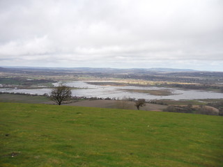
Amberley Wild Brooks on the River Arun
SWC Walk 26 - South Downs Way: Amberley to Shoreham-by-Sea or Lancing
Mar-20 • thomasgrabow on Flickr
swcwalks swcwalk26 walkicon 49651835501

Lancing College
SWC Walk 26 - South Downs Way: Amberley to Shoreham-by-Sea or Lancing
Mar-20 • thomasgrabow on Flickr
swcwalks swcwalk26 walkicon 49651833811

Old Shoreham Bridge (over River Adur)
SWC Walk 26 - South Downs Way: Amberley to Shoreham-by-Sea or Lancing
Mar-20 • thomasgrabow on Flickr
swcwalks swcwalk26 walkicon 49652107012

| Length |
25.0 km (15.5 mi) to Shoreham-by-Sea. Shorter options: 19.4 km (12.1 mi) to Upper Beeding (for a bus to Shoreham) or 22.3 km (13.9 mi) to Lancing Station Add an extra kilometre (and 25m ascent) to any ending if you detour to Washington for a safe road crossing and The Frankland Arms lunch pub. |
|---|---|
| Toughness |
7 out of 10 with 470m (1,530 ft) of ascent - 2 steep climbs, otherwise gentle gradients) |
| Maps |
OS Explorer OL10 (Arundel) and OL11 (Brighton) |
| Features |
This walk, which can be done in either direction, follows the South Downs Way (SDW). The route follows the crest of the South Downs Ridge with good views in both directions. It passes Chanctonbury Ring, a ring of beech trees planted on the remains of a prehistoric Hill Fort. This spot has beautiful 360° views and is the recommended picnic spot. Apart from the endings in Lancing or Shoreham, the route is very well way-marked. All the paths are wide, easy to walk on, and easy to follow. The route is almost entirely over an open, treeless, chalk ridge, with good views. It is very exposed in bad or windy weather though. At the halfway point, there is a break in the ridge, where the route crosses the busy A24 dual carriageway. There is a wide grassy median, so you can cross in stages. There is a longer 'via Washington alternative' which avoids this crossing and passes a walker friendly pub. There is an official South Downs Way drinking water tap just before the A24 road crossing. |
| Walk Options |
|
| Travel |
Buy a return to Ford. Amberley and Shoreham/Lancing are on different lines, but a ticket to Ford (where the two lines converge) is the same price as Lancing, and is valid for both stations.
Suggested Train: Take the train closest to 9:45 from Victoria. By car - check. Up to two changes, about an hour to return to your car (Amberley to/from Shoreham or Lancing). |
| Lunch |
The main walk is a picnic walk only. The 'via Washington alternative' passes the The Frankland Arms (01903 891405) in Washington [Jan-20 : reopened, mains ~ £10] |
| Tea |
Finish in Upper Beeding : two very nice pubs to await your bus to Shoreham, the Bridge Inn and the Kings Head. Finish in Lancing: The station is at the start of the high street. Just after it is the Farmers Lancing pub, and 600m after it is Lancing's pebble beach with the Perch cafe/bar right on the seawall / promenade Finish in Shoreham : there are several nice pubs by the river on the way to the station, with outside terraces at the back overlooking the river. There is a cop-op supermarket just before the pedestrian bridge, and a small convinience store right next to the station. Shoreham Beach : pub, convenience store selling coffee and cakes. |
| Swimming |
Lancing has a pebble beach. Its 600m further south past the station. You could walk along the very pleasent pedestrian sea wall path to Shoreham beach. Shoreham-by-Sea has a large pebble beach. Take the footbridges from the main street across the harbour/estuary, and continue on for 250m. See the end of the main walk directions for more details. |
| South Downs Way |
This walk is one of 9 stages of the South Downs Way - a 109 mile national long distance path - that traverses the South Downs National Park in South East England. |
|---|---|
| Profile | |
| Help Us! |
After the walk, please leave a comment, it really helps. Thanks! You can also upload photos to the SWC Group on Flickr (upload your photos) and videos to Youtube. This walk's tags are: |
| By Train |
Out (not a train station) Back (not a train station) |
| By Car |
Start BN18 9LT Map Directions Return to the start: Finish BN43 5WX Map Directions Travel to the start: |
| Amazon | |
| Help |
National Rail: 03457 48 49 50 • Traveline (bus times): 0871 200 22 33 (12p/min) • TFL (London) : 0343 222 1234 |
| Version |
Jul-22 Andrew |
| Copyright | © Saturday Walkers Club. All Rights Reserved. No commercial use. No copying. No derivatives. Free with attribution for one time non-commercial use only. www.walkingclub.org.uk/site/license.shtml |


Walk Directions
- Leaving Amberley station, turn left and walk down to and across the main road, then turn right along the opposite pavement and follow the road past the entrance to Amberley Museum. In 60 metres the footpath continues to the left of a hedge for 150 metres.
- In 35 metres turn right across the main road and up High Titten (lane) with the South Downs Way (SDW), signposted in 25 metres ('Washington Village 6 1/4 miles').
- Follow the waymarked SDW, leaving the road for a path, which continues for several kilometres, passing two car parks.
In more detail:- At the top of the rise (with views on the left to Amberley Castle and Amberley Wild Brooks), where a road and the Wey-South Path join from the left, keep straight on. In another 100 metres, fork left between wooden barriers up a gravel path, signposted South Downs Way on the right.
- In 50 metres go through a wooden gate and in 270 metres, where the slope levels out, a farm track joins from the right behind (a signposted restricted byway). In 50 metres go through a wooden gate to the left of a double metal field gate and follow the track straight on up the ridge (Amberley Mount), ignoring another track to the right.
- In 400 metres, at the top, you pass through a wooden gate to the left of a wooden field gate. Here you can either remain on the track, or go through the kissing gate to the left, into Access Land (Springhead Estate) which gives you a better view from the escarpment. If continuing through the Access Land, in 950 metres you cross a stile (to the side of some metal field gates) by some earthworks on the left and in 25 metres there is a gate to the right that would allow you to rejoin the main track at a signposted bridleway junction on the right. But you can if you wish stay in the Access Land for another stretch, in 50m going over another stile to the right of a metal field gate and then climbing a hill and carrying on for another 900 metres or so (passing Rackham Hill's trig point away on the right), until a wooden kissing gate to the right of a metal field gate allows you back onto the main track.
- Whichever way you have come, in 100 metres a restricted byway joins from the right behind and you follow the SDW through a wooded belt and carry on gently downhill.
- At the bottom of Springhead Hill there are a couple of car parks to the left. Again you can just stay on the SDW over the next long gentle rise (Kithurst Hill, with its top away to the left), eventually descending to another small car park in 1.7 kilometres. But more rewarding is to turn left at the end of the first car park past a double metal field gate (where a road comes up the hill to the car parks) and turn right immediately through the second car park to pick up a fenced path in 90 metres at its far end that runs parallel to the SDW you have just left. Follow this for 1 kilometre, and just over the top of the hill, just past a trig point, you get a fine view to the left. To rejoin the SDW stay on the path, with a fence to your right, until it curves right to a road. Turn right on the road and follow it a short way uphill to the car park, and turn left to resume the SDW.
- In another 800 metres you cross a cattle grid, and [!] veer left with the SDW along a car wide track, passing to the left of a barn (the more obvious route anyway).
- Just over the brow of the next hill (Barnsfarm Hill), you pass through a gate. In 200 metres more, on the left, there is a car wide path signposted "South Downs Way via A24 bridleway bridge, Washington Village 1 mile".
- Here you have a choice, the main route (shorter, crosses a busy road, no pub), or the Washington alternative (longer and with additional ascent, nice pub, no busy road crossing). Both routes meet up at Chanctonbury Ring
- Option 1) Stay on the SDW
- Continue straight on along the SDW. Head downhill to the busy A24. Just 50 metres before the final right turn to the crossing point, there is an official SDW Drinking Water Point (a tap) on the right. Follow signposts to the crossing point, where there is a wide grassy median, so you can cross safely, in two stages.
- Follow the SDW back up to the ridge again, and onto Chanctonbury Ring.
- Option 2) The longer 'via Washington' alternative
- Turn left on the "South Downs Way via A24 bridleway bridge" track.
- Follow the track as it goes over the brow of the hill and down the escarpment, and then bear right with it, initially through trees. It slants down across a big open space as a car wide fenced chalky track. On the far side of this open area fork left along a car wide track down through trees with the signposted SDW.
- At a four-way junction at the bottom of the descent (just after passing Home Farm Cottage on the right), continue in the same direction through a wooded boundary, and turn right at a T-junction just beyond it.
- Cross the A24 on a footbridge, and keep on past the church downhill on a village road (the village is called Washington, but is not named as such here), until you come to a T-junction at the bottom. Turn left and the lunchtime pub, the Frankland Arms is in 100 metres or so on the left.
- After lunch, come out of the pub and turn right on the road. In 30 metres, go left over an easily missed stile, and veer right across the field beyond to another stile in the corner. Carry on along a fenced in path around a field.
- Cross a track, and go over a stile into the next field, and bear right up across it to a stile at the top of the field. Carry on uphill beyond it, and at the far end of this field, cross a stile and turn left into a large field, with the escarpment now visible to your right.
- Keep on along the left hand edge of this field, parallel to the escarpment. Just beyond half way along the next field, by a footpath signpost on the left, bear diagonally right across the field to a metal gate (may be temporary) about 150 metres from its left hand corner.
- Carry on across the next two fields towards some trees. At the far end of this field you reach a gate. Beyond this, go right (not straight ahead, which seems more obvious) up a car wide track that starts to climb uphill.
- In 60 metres, take the path that goes left off this track, directly uphill, passing a hollow to your left. The path curves left around the top of the hollow, and flattens out for a while. But it soon starts to climb - relentlessly and steeply - and eventually brings you up to Chanctonbury Ring, an ancient hillfort now covered in trees.
- To get back on the South Downs Way, pass to the right of the Ring, and follow the obvious track.
- Both Routes continue
- Follow the SDW past Chanctonbury Ring, and along the ridge. After 3.5 kilometres, the SDW comes down to a road (the track goes up to the road and then veers away again to the right: but you go onto the road, following the SDW sign)
- Cross the road, and take the path parallel to it on the far side, signposted SDW. In 150 metres, there is a concrete track descending to the left, just before a wooden gate to the right of a metal field gate.
- Here you have the option of finishing in Upper Beeding (much shorter, nice pubs, bus to train station)
- To finish in Upper Beeding: Turn left here, downhill, along the Monarch's Way. The track becomes a tarmac lane, which leads down to a roundabout in front of Bramber Castle (worth a quick look). Cross the roundabout, go east along "The Street" road. Tea options include the Old Tollgate Hotel opposite the castle, and pubs slightly further on. Buses (Line 2) go to Shoreham Station from stops on the left hand side of the road.
- To carry on with the main walk to Lancing or Shoreham stations, however, ignore the concrete track, and keep on through the gate ahead on the SDW, parallel to the road. In 550 metres you pass through a gate.
- To finish in Shoreham via the valley: Turn left through a wooden gate and along a field boundary, soon downhill, following the South Downs Way. Turn right (signed SDW) on a lane at the bottom of the hill. Where the SDW leaves the lane to head for the river, continue on for 50m to visit St Botolph's Church. In the middle ages, there was once a major port here!. Retrace your steps, and head down to the river. Turn right and in a few hundred metres turn left over the first footbridge over the river to continue with it now on your right hand side. Now follow a mix and match of the riverside path or former railway paths for 4km into Shoreham. The two paths converge as you go under the A27. You come to the picturesque Old Shoreham Bridge, now pedestrian. Turn right across the bridge over the river and on the far side turn left along a signposted footpath that takes you out along a concrete wall along a gravel path, soon on top of the new seawall along the River Adur estuary to your left. Continue below at "Valley Route rejoins".
- Here you leave the South Downs Way. Carry straight on along the grassy verge (a signposted public bridleway) and in 120 metres continue in the same direction through a small car park and a wooden gate (with a "Private Field" sign) where the road turns right. You continue along a field edge, with a fence on the left which gently curves to the right (your direction 170°). Halfway along the field in 170 metres go through a metal field gate to join a fenced car wide track running along the left hand side of the field.
- Follow the fenced path down through a valley towards the hill ahead (Steep Down) and eventually to the car park marked on the OS map.
In more detail:- In 350 metres go through a wooden gate to the right of a metal field gate and keep straight on, heading towards the large rounded hill ahead (Steep Down) on a car wide track.
- In 400 metres, at the hill, continue in the same direction at a signposted four-way junction, and in 40 metres keep to the left of it along the signposted Restricted Byway (unless you want to go over the top along the Public Bridleway), and simply keep straight on along this track for another 2 kilometres as it follows a ridge downwards and then up towards a hill (Lancing Ring) crowned with rather scrubby woods.
- Some distance beyond the brow of the hill (just after passing two metal field gates in quick succession), you come to a fork marked by a signpost by a car park on the right.
- Here you have 2 options - finish at Lancing (shorter, 1.5 kilometres, urban road walking), or Shoreham-by-Sea (longer, about 3 kilometres, more interesting, chance to swim)
- To Finish at Lancing Station: Fork right at the signpost with the Restricted Byway. You soon come to houses and need to make your way more or less in a straight line through the town (due south) for about 1.5 kilometres to the station. Continue south, past the station, for a beach.
- To continue the main walk towards Shoreham Station, fork left at the signpost with the Public Bridleway.
- Follow the path as it curves left towards Lancing College (a famous private school). In 400 metres fork left along the fence, ignoring a right turning public footpath (as per a signpost 30 metres away in the trees). In 300 metres the path joins a tarmac drive (leading to a house on the right). Carry on in the same direction, but when the drive turns sharp right in 180 metres (as a signposted Public Footpath), keep on down a car wide track (a signposted bridleway) that passes a house and narrows to a path.
- Eventually this brings you to a tarmac drive, leading to Lancing College on the left. Turn right here, passing houses on the right. In 300 metres you come to a T-junction and turn right. In 100 metres, this road comes to a dead end, and you pass through a hedge gap to emerge on the A27 dual carriage way. Turn left along a tarmac path along its edge.
- Cross the A27 at the traffic lights, and go down the dead end Old Shoreham Road on the far side.
- You pass the lane leading to Shoreham Airport on the right and keep on down the road. In 100 metres ignore another tarmac lane to the right, but just beyond it [!] turn right on a signposted footpath that takes you out along a concrete wall along a gravel path, soon on top of the new seawall along the River Adur estuary to your left. [Valley Route rejoins] This eventually brings you under the railway bridge: beyond it turn left with the path and in 130 metres continue alogn a garvel, then tarmac drive to the right of a playground to eventually emerge onto a busy road.
- Turn left on the road and over Norfolk Bridge over the Adur. On the far side, turn right along Shoreham High Street.
- Continue along it until the 6th road on the left, East Street.
- For the beach: , go right across the harbour footbridge opposite East Street. Beyond the bridge, turn left for a short while and then right before the pub. Note that there is a convenience store to the left on the road down to the beach that sells hot coffee and cakes and is open late.
- To continue to Shoreham Station, turn left into East Street.