Brockwell Park walk
Short amble through a small but well-kept urban park in South East London on raised ground

Brockwell Hall Cafe
SWC Short Walk 39 - Brockwell Park (Herne Hill Circular or to Brixton)
Apr-18 • thomasgrabow on Flickr
swcwalks short39 banner 41536974912

Walled Garden, Brockwell Park
SWC Short Walk 39 - Brockwell Park (Herne Hill Circular or to Brixton)
Apr-18 • thomasgrabow on Flickr
swcwalks short39 walkicon 41577757331
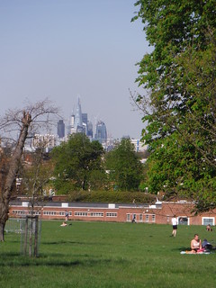
City of London from Brockwell Park
SWC Short Walk 39 - Brockwell Park (Herne Hill Circular or to Brixton)
Apr-18 • thomasgrabow on Flickr
swcwalks short39 walkicon 41537037472

19th Century Clocktower, Brockwell Park
SWC Short Walk 39 - Brockwell Park (Herne Hill Circular or to Brixton)
Apr-18 • thomasgrabow on Flickr
swcwalks short39 walkicon 40684983405
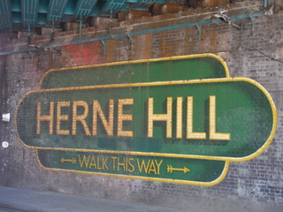
Welcome to Herne Hill! Under the Railway Bridge
SWC Short Walk 39 - Brockwell Park (Herne Hill Circular or to Brixton)
Apr-18 • thomasgrabow on Flickr
swcwalks short39 26709652017

Brockwell Park, Herne Hill Entrance
SWC Short Walk 39 - Brockwell Park (Herne Hill Circular or to Brixton)
Apr-18 • thomasgrabow on Flickr
swcwalks short39 41577920491

Brockwell Lido, Entrance
SWC Short Walk 39 - Brockwell Park (Herne Hill Circular or to Brixton)
Apr-18 • thomasgrabow on Flickr
swcwalks short39 40685312675
| Length |
3.9 km (2.4 mi) Ascent: 40m Time: 1 hour walking time. |
|---|---|
| Transport |
Herne Hill station is located on the boundary between Zones 2 and 3 and served by Southeastern trains on the Chatham Line from Victoria to Orpington, and by Thameslink services on the Portsmouth Line to Sutton. Travel time from Victoria is 9 minutes, from Blackfriars 11 minutes. Denmark Hill station (Zone 2) is on the South London and Catford Loop lines. Brixton station (Zone 2) is also on the Chatham line, same as Herne Hill but one stop closer to Victoria, and the southern terminus of the Victoria Line Underground. |
| Walk Notes |
Meandering route through a small but well-kept urban park in Southeast London on raised ground within the valleys shaped by one of London's Hidden Rivers, The Effra, and a couple of its tributaries. Created from the purchase of the existing private gardens of the Brockwell Hall estate and some smaller neighbouring properties, it is noted for its 19th century layout as a gracious public park, a clocktower, water garden, and walled garden, as much as for the Art Deco Brockwell Lido. Brockwell Hall has served as a cafe since the opening of the park in 1892. An Alternative Start from Denmark Hill Station leads through Ruskin Park and down along quiet residential streets to Herne Hill Station. This adds 2.8 km and 30m ascent to the route.
|
| Eat/Drink |
Four Hundred Rabbits at the Lido Café, Dulwich Road, Brockwell Park, Herne Hill, SE24 0PA (020 7737 8183).
Plenty of options near the stations, see text below for details. |
| Notes |
Ruskin Park Ruskin Park lies on Denmark Hill, bordering Camberwell, Herne Hill and Brixton. It was created at the start of the 20th century on 10 hectares (24 acres) of land after local residents campaigned for a new public park. The park was laid out by Lt-Col JJ Sexby, the Chief Officer for Parks for the LCC, and it included an Old English Garden, an oval duck pond, a bandstand and a bowling green. The bowling green has been replaced by a garden, but the other features remain. In 1910 Ruskin Park was enlarged by the addition of a further 5 hectares to the south west. The park has more than 870 trees. The existing houses on the site were demolished when the park was created. One of these was Dane House, where, in 1842, Felix Mendelssohn composed Spring Song. The former entrance porch to one of the demolished houses remains in the park. In 1967, the band Pink Floyd used the park for their first official photoshoot. The park is named after John Ruskin (1819 – 1900), a prolific Victorian author, artist, art critic, and social reformer. He grew up in Herne Hill and lived in Denmark Hill for nearly 50 years. https://www.friendsofruskinpark.org.uk/ River Effra The River Effra is a converted river or former large stream in south London, now mainly underground. Directionally the Effra travelled mainly NNW from Upper Norwood until north of Brixton where it then fed Lambeth Marsh and Walworth Marsh, joining Earl's Sluice and entering the Thames at Deptford Wharf. It was diverted in the 13th Century to run west from Kennington to join the Thames at Vauxhall. Due to its history and the pressing need in the late Victorian era for a surface water drainage system, its contours have been used for a combined sewer, draining for example much of the historic broadly defined areas of Peckham and Brixton. When the London sewerage system was constructed during the mid-19th century, it incorporated flows from the River Effra into the Southern High Level Sewer, also known as the Effra sewer, running from Herne Hill eastwards under Peckham and New Cross to Deptford and from Putney, the Southern Low Level Sewer picking up remaining effluent from the old depression converted to sewer at Vauxhall, passing under Kennington and Burgess Park to Deptford merging to form the Southern Outfall Sewer that runs underneath Greenwich and Woolwich to Crossness. Brockwell Park and Hall Brockwell Park is a 51ha park located between Brixton, Herne Hill and Tulse Hill, created when in 1891 Lambeth Council bought Brockwell Hall and its gardens as well as two adjacent smaller properties: Clarence Lodge and Brockwell House. Because these gardens were never developed, the park retains traces of the watercourses that used to run through them: The River Effra and a couple of its tributaries. The Park has commanding views of the skyline of the City and of Central London and is noted for its 19th century layout as a gracious public park, the clocktower, water garden, JJ Sexby designed walled garden and other monuments and links to its 18th century agricultural past in the hedge lines and mature oak trees. The Brockwell Lido is a Grade II listed art deco building. Brockwell Park is open from 07.30 to 15 minutes before sunset every day. The Park is home to the annual free Lambeth Country Show, and has hosted many large-scale music events with up to 150.000 spectators (Rock Against Racism 1978). The Grade II* listed Brockwell Hall was built between 1811-1813 when the area was part of Surrey and was the country seat of glass merchant John Blades Esq. After a campaign led by the local MP Thomas Lynn Bristowe, the land and house were acquired by the London County Council in March 1891 and the park opened to the public in the following summer. At the unveiling, Bristowe died of a heart attack on the steps of the hall. A bust of him is on display in the Hall. http://www.friendsofbrockwellpark.org/ https://brockwellparkcommunitypartners.org.uk/ |
| Profile | |
|---|---|
| Help Us! |
After the walk, please leave a comment, it really helps. Thanks! You can also upload photos to the SWC Group on Flickr (upload your photos) and videos to Youtube. This walk's tags are: |
| By Train |
Out (not a train station) Back (not a train station) |
| By Car |
Start SE24 0JW Map Directions |
| Amazon | |
| Help |
National Rail: 03457 48 49 50 • Traveline (bus times): 0871 200 22 33 (12p/min) • TFL (London) : 0343 222 1234 |
| Version |
Apr-24 Thomas G |
| Copyright | © Saturday Walkers Club. All Rights Reserved. No commercial use. No copying. No derivatives. Free with attribution for one time non-commercial use only. www.walkingclub.org.uk/site/license.shtml |

Walk Directions
- Leave the platform down some steps and exit the station past the Perks & White cafe (Mon-Fri 07.00-12.30 only) on the left and the Minus 12 craft ice cream parlour (Wed-Sat 12.00-19.30 and Sun 11.00-17.30) on the right in the ticket hall onto Railton Road, opposite The Commercial hotel and pub and with Llewellyn's restaurant and its offshoot Lulu's Wine Bar on the right (there is a farmer's market here every Sunday 10.00-16.00).
- Turn left along the road. In 100m at a junction with Dulwich Road, cross the road at a pedestrian crossing and over a traffic island, where you cross one of London's 'Hidden' or 'Lost' Rivers, The Effra (Dulwich Road was formerly called Water Lane). Proceed towards the Herne Hill Entrance to Brockwell Park and enter the park through the wrought iron gates.
- Turn right along the furthest right of three tarmac paths, initially following the tree-lined right-hand park boundary, with Dulwich Road audible behind, broadly following the course of The Effra away to the right. In 50m you pass the Herne Hill Gates station of a miniature railway (open 11.00-16.00 summer Sundays) and in 150m the far end of the railway. You turn left in 25m by the Lido/Dulwich Road Entrance to the park and in 20m pass Brockwell Lido. The recommended Four Hundred Rabbits at the Lido Café can be found along the tarmac path around the right-hand side of the Lido, 70m away.
- In 10m and again in another 30m fork right along the right of two paths and continue with the lido on your right. In 90m ignore a left turning path up an incline and in 100m at the end of the line of trees hiding a football pitch on your left, [!] you turn left up a grassy incline. In 70m, at the end of a hedge on the left and by a fence corner, turn left and follow the fence on the right. In 100m turn up to the right at a T-junction with a tarmac path.
- You pass a BMX Track on your right-hand side and then a fenced bowling green on your left-hand side. At the far end of the fence veer right a little downhill at a four-way tarmac path junction. You are descending into the shallow valley of one of the smaller tributaries of the Effra River.
- In 130m at a four-way junction with a playground away on the right and a fenced area ahead, you veer right a little and continue to the right of the fence. In 40m at the far end of the fence turn left, ignoring the continuation of the path towards the Tulse Hill Entrance of the park. In 20m turn left to cross the outflow of a pond on the right over a bridge and then weave your way through a succession of three ponds (fed by the tributary stream) by turning right, right again (re-crossing the stream) and then left and left again (re-crossing the stream), and eventually you reach a walled garden and turn right to continue with the walled garden on your left.
- In 80m at the far end of the wall around the garden, turn left back on yourself and enter the walled garden through a metal gate. After a tour of the garden, leave it through the same gate and turn up left along a tarmac path past 'The Temple', now serving as a toilet block, with an info panel on garden and temple just beyond it.
- Continue uphill along the path, soon passing Community Greenhouses, some tennis courts and a wooden shelter, enjoying some fine views to The City and Canary Wharf on the half left. At the far end of the plateau at the top of the rise turn right with the path.
- In 140m turn right along a tarmac path and in 70m you have Brockwell Hall away on the left across a grassy area. In 140m turn left at a T-junction. In 25m turn left towards a clock tower (from 1897) 20m away and continue to the right of it.
- In 90m turn right into Brockwell Hall and walk past a bust of Thomas Lynn Bristoe MP, leader of the campaign to create the park, and through Brockwell Hall Café to exit on the other side onto its terrace. [If the café is already closed for the evening, pass the hall to its left hand side.]
- Turn right on the terrace on the other side of the café and in 30m from the café exit ignore a left turn downhill. In 60m turn right with the path and in 50m, with the clock tower on the right, you have a choice:
- For the Brixton Ending pick up the directions below, for the Herne Hill Ending, turn left downhill. You curve left with the path into the valley of the Tulse Hill tributary of the Effra and in 300m at the bottom of the descent by the Brockwell Park Gardens (Vehicle) Entrance turn left at a four-way junction.
- In 80m ignore the Norwood Lodge Entrance and bear left, passing the fenced park gardener's yard on your right. In 50m a path joins from the left down the hill and in 170m an optional right fork leads you to the Rosendale Road Exit from the park, on across Norwood Road and along Rosendale Road to the recommended Bullfinch Brewery Tap Room (open to 22.00 Tue-Sun), just before the railway bridge on the left-hand side.
- Continue along the path through the park, with Brockwell Hall up on the left across the slope, and in 420m leave it through the Herne Hill Entrance. For the direct route to the station, retrace the steps from earlier, along Railton Road.
- For other tea or dinner options:
- - either turn hard right along Norwood Road: on the opposite side you'll find Saray Turkish restaurant, Canopy Beer Co. Brewery & Tap Room (in a backyard), the recommended Park's Edge bar & kitchen, Olley's fish & chips and Steve's Café;
- - or turn half right under the railway bridge and on along Half Moon Lane (sight of a devastating flood on 7 August 2013, caused by a burst water main and flooding 36 properties): you'll find Elsewhere coffee roasters, Wild + Lees wine and beer bottle shop, Peachy Goat, The Half Moon pub, Flo's café and Lombok Thai;
- - or cross Dulwich Road and turn left on the opposite pavement, in 20m passing the 500 Degrees pizza restaurant and in 60m you reach the recommended pub The Florence. By the pub turn right along Brockwell Passage and in 60m turn right towards Herne Hill station.
Denmark Hill Start
- Leave Denmark Hill Station to the right from the direction of travel from Central London, signed 'Champion Hill and Buses', as well as 'King's College Hospital and Maudsley Hospital' (i.e.: not 'Windsor Walk') onto Champion Road, with the imposing William Booth Memorial Training College building a little to the left (Salvation Army, Grade II listed, designed by Sir Giles Gilbert Scott of Battersea Power Station, Liverpool Cathedral and red phone box fame).
- Turn right along the pavement of the road, with a 'Ruskin Park' sign tied to a lamp post on the far side. At the end of the station building, you cross Windsor Walk, with FCB Coffee and The Phoenix pub away on the right in the station building.
- In 40m you pass a bus stop and the brand new Salvation Army Territorial HQ on the left and have Maudsley and King's College Hospitals away to the right beyond the railway tracks. In 50m cross Denmark Hill (road) at a set of lights (crossing from Southwark into Lambeth in the process) and turn left to an entrance in to Ruskin Park. In 20m go through a metal gate into the park.
- Ignore an immediate left turn and in 40m ignore some steps up to the left. In 60m fork left (i.e.: do not turn left) and in 50m continue either side of a bandstand (of 1911 and restored in 2006). In 40m from the far end of the bandstand, at a four-way junction, turn left and in 40m turn left again and curve to the right around most of the circumference a railed pond. In 130m you get back up to its top end.
- This pond is fed by underground springs and is considered to be the source of one of London's Lost Rivers, The Earl's Sluice. It was largely diverted into the Earl's Sewer in the 1820s, but its original course still forms the boundaries between Walworth and Camberwell, then Bermondsey/Rotherhithe and Deptford (and hence Kent and Surrey - as it was) on its route to the Thames by the South Dock.
- Turn left away from the pond along a tarmac path (ignore an earthen path across grass to the left and another one ahead up some low steps) and in 70m turn right at a multi-path junction to go up some steps and pass The Portico on the right, a remnant of one of the seven buildings that were demolished to make way for the park (Grade II listed). There is a flagpole with a Green Flag Award on the left.
- In 50m turn right off the ascending path and in 40m fork right along the more major path. In 20m you pass a broad tarmac path under a pergola on the left. This runs along the top of the Labyrinth Garden walked through next.
- In 35m, just before a crescent-shaped path leading down to the level of the pond, turn left into the graden. In 25m pass an info panel on the Mendelssohn Sundial visible in the middle of this small formal garden, formerly a bowling green. Take any route through the garden (grass paths through the centre, pavement along the sides) and leave it at the far end from where you entered it.
- At a four-way junction of tarmac paths (with the bandstand ahead and the pond away to the right), turn left along a level path, between rows of trees and through the middle of the park, with the gentle slope to the right down into the Thames Valley.
- In 70m you pass the corner of a fenced sports field away to the right and have largely left the hospitals behind. This opens up the views into the valley, with the high rises of Nine Elms most prominent. In 75m, at a fork, the BT Tower, London Eye and Shard can be spotted as well. Fork left to pass to the left of a wooden shelter and in 30m bear left uphill towards the top park boundary.
- In 70m turn right at a four-way junction to continue along a tarmac path parallel to the boundary fence, with Ferndene Road behind. In 30m you pass a toilet block and in another 320m leave the park to the left onto the road pavement and turn right along it. [But the Ruskin Park Café is to be found in the bottom corner of the park at this end.]
- In 40m cross Herne Hill Road by the beautiful Carnegie Library on the left (Grade II listed) and continue along the quiet residential road for 670m. You cross Poplar Walk (the road changes name here to continue as Fawnbrake Avenue) and late on you ignore two roads joining from the left and eventually get to a T-junction with Gubyon Avenue.
- Turn left uphill along the road. In 90m cross Shardcroft Avenue and in another 80m turn right along Woodquest Avenue. In 60m continue along a paved path between some houses of Oborne Close.
- In 25m you emerge on a raised path above Railton Road, with Herne Hill Station's platforsm on the far side of the road behind a fence. Turn left down a sloping path to continue along the pavement and drop down with the road. In 150m turn right across the road at a pedestrian crossing and enter a subway a little to the right to go under the tracks past Arcade Coffee & Co.
- In 50m you emerge on the station forecourt, where the Circular Walk begins.
Brixton Ending
- Continue in the same direction, gently descending towards some ponds. In 150m continue to the left of the walled garden and to the right of the first pond. In 90m and in another 80m ignore left turning paths and continue to the right of the ponds. In 50m curve left with the path, ignoring a fork to the right and in 30m turn right at a T-junction of tarmac paths.
- In 30m turn left at a four-way junction towards the Tulse Hill Exit from Brockwell Park and in 70m leave the park and cross Tulse Hill (road) at a set of lights to continue in the same direction through the red brick Tulse Hill Estate.
- In 220m turn left a T-junction with Leander Road, gently uphill, and in 80m turn right along Helix Road. In 50m, where the road turns right, turn left up some steps 10m away into an estate of low rise houses and turn right along Cherry Laurel Walk between rows of houses (with a 'Footpath Only'-sign on the right).
- In 60m turn right down between metal bike barriers and turn left past a metal car barrier to continue along Beechdale Road. In 60m turn right along Fairmount Road and curve left with the road.
- In 300m, cross the A 23 Brixton Hill (road) at a set of lights and continue a little to the right along Blenheim Gardens. In 125m you pass a Royal Mail Delivery Centre on the right-hand side of the road and in 110m continue to the right of a metal car barrier.
- In 30m bear left to enter Windmill Gardens through a double metal gate. Brixton Windmill is 50m away, and some info panels are mounted on a wall.
- Return the way you came back to the Royal Mail Delivery Office and turn left immediately after it along Halliwell Road. In 90m turn left along St. Saviour's Road at a T-junction and in 100m turn right along Lambert Road at a T-junction.
- In 200m turn left along Brixton Hill and in 30m at a four-way junction, turn right to cross it at a set of lights and immediately turn left to cross Brixton Water Lane to enter Rush Common and follow a tarmac path through it.
- In 400m leave the common back onto the A road's pavement and turn right along it. You pass a community orchard on your right (on the site of a Cold War Nuclear Bunker) and in 50m cross St. Matthew's Road at a set of lights.
- Continue to the left of the fenced church yard but in 50m turn right through a metal car wide gate and continue to the left of St. Matthew's. In 30m enter St. Matthew's Church Gardens through a gap in a metal fence (on the left across the road you have first Electric Brixton Concert Hall and then Lambeth Council Hall).
- In 75m leave the gardens to the right of a monument and cross Effra Road (with the river running below it) and cross Windrush Square past Brixton Library to its far-left corner by the Ritzy Cinema (you have the Black Cultural Archives away on the right as well as a War Memorial for African and Caribbean Men and Women killed in WWI and WWII).
- By the cinema cross Coldharbour Lane and continue along the right-hand pavement of the A23 Brixton Road.
- In 100m either continue down the road for 40m to go straight to Brixton Underground station, or (recommended) ,turn right along the pedestrianised Electric Avenue.
- You cross Electric Lane in 40m and curve left with Electric Avenue and in 80m cross Atlantic Road to go along Pope's Road under the first of two railway lines and in 75m reach Brixton Station Road at a T-junction.
- You have the station entrance 20m away on your left and the entrance to Pop Brixton across the road, providing numerous interesting food and drink options over two floors.
- For Brixton Underground station, turn left along Brixton Station Road and in 125m turn left along Brixton Road to in 100m reach the station.