Burgess Park (Peckham Rye to Elephant and Castle) walk
The Grand Surrey Canal and a succession of parks and open spaces in gritty inner southeast London
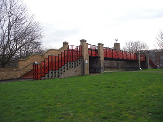
Bridge to Nowhere, Burgess Park
SWC Short Walk 59 - Burgess Park (Elephant & Castle)
15-Feb-24 • thomasgrabow on Flickr
banner swcwalks short59 53531034038
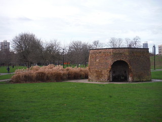
Limekiln, Burgess Park
SWC Short Walk 59 - Burgess Park (Elephant & Castle)
15-Feb-24 • thomasgrabow on Flickr
walkicon swcwalks short59 53529948517

Addington Square, Camberwell
SWC Short Walk 59 - Burgess Park (Elephant & Castle)
15-Feb-24 • thomasgrabow on Flickr
walkicon swcwalks short59 53530842046

Fishing Lake, Burgess Park
SWC Short Walk 59 - Burgess Park (Elephant & Castle)
15-Feb-24 • thomasgrabow on Flickr
walkicon swcwalks short59 53531032213

Houses on Elm Grove, Peckham
SWC Short Walk 59 - Burgess Park (Elephant & Castle)
15-Feb-24 • thomasgrabow on Flickr
swcwalks short59 53529950347

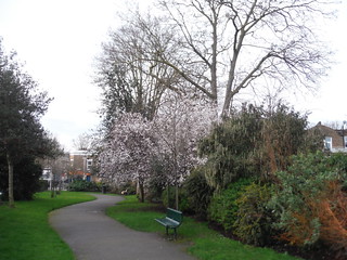
Holly Grove Shrubbery
SWC Short Walk 59 - Burgess Park (Elephant & Castle)
15-Feb-24 • thomasgrabow on Flickr
swcwalks short59 53531035723
Holly Grove Shrubbery
SWC Short Walk 59 - Burgess Park (Elephant & Castle)
15-Feb-24 • thomasgrabow on Flickr
swcwalks short59 53531276330
| Length |
7.1 km/4.4 mi with negligible ascent/descent and 1 ½ hours net walking time. |
|---|---|
| Walk Notes |
An urban route entirely in the London Borough of Southwark, leading through some gritty parts of inner southeast London but largely along green corridors or through parks. You walk through some quiet streets in North Peckham and along a linear park on the line of the Peckham Branch of the infilled Grand Surrey Canal to Burgess Park, created on land formerly filled by industry around the canal as well as dense housing but heavily bombed in WWII, and now with only a few listed remnants of its industrial and canal heritage, such as almshouses, a well-preserved limekiln and the ‘Bridge to Nowhere’.
The areas walked through are a mix not atypical of the Borough of Southwark: well-kept parks and open spaces, some old and worn council estates (often of brutalist architecture), plenty of reused or part-replaced former industrial buildings, some new and more enlightened council accommodation as well as some fully gentrified areas, culminating in the still not quite finished Elephant Park. Terrain & Access: Almost only hard surfaces. The parks and open spaces on the main walk are open 24/7.
|
| Eat & Drink (selected) |
Motown Caffé, Coal Rooms restaurant, café and bar, Persepolis Persian restaurant, The Kentish Drovers, Fowlds Café, Clubhouse Café, Stomping Grounds Café, Burgess Park Angling Club Café, Amigos, HEJ Coffee, Diogenes and the Dog wine bar, several recommended places in Elephant Park and in the railway arches, Elephant and Castle pub, The Rockingham Arms. |
| Transport |
Start: Peckham Rye Mainline and Overground
Peckham Rye Station is located in Travelcard Zone 2 and served by the East London Line (Overground), Thameslink and Sutton & Mole Valley services; trains arrive from Dartford, London Bridge, Victoria, Highbury & Islington, Blackfriars, Sevenoaks, West Croydon, Beckenham Junction and Clapham Junction. Elephant & Castle Station is located in Travelcard Zones 1 and 2 and is served by Thameslink services along the Wimbledon Loop line and by trains to Sevenoaks via Catford. The Underground station is served by the Northern Line (Bank branch) as well as being the southerly terminus of the Bakerloo Line. |
| Notes |
Grand Surrey Canal The Grand Surrey Canal (GSC) was a canal constructed during the early 19th century, with plans to link the Surrey Commercial Docks at Rotherhithe with Mitcham and later Portsmouth. It opened from Rotherhithe through Deptford and South Bermondsey to the Old Kent Road in 1807, on through Walworth to Camberwell in 1810, and the branch to Peckham in 1826. A short-lived Croydon Canal was built as a separate enterprise and linked to the GSC at New Cross. The GSC ran through flat terrain and needed no locks or inclines, while any development further south would have necessitated locks and therefore been much more expensive.
Burgess Park At 56 hectares (140 acres), Burgess Park is Southwark's largest park and the only area in South London to have been de-urbanised. The park stretches from Camberwell and Walworth to Peckham and the Old Kent Road. It is named after Camberwell's first woman Mayor, Jessie Burgess. The park was built between the 1950s and 1980s and developed as a result of the Abercrombie Plan for open spaces made in 1943.
Aylesbury Estate The Aylesbury Estate in Walworth in the London Borough of Southwark was designed in the brutalist style and built between 1963 and 1977 on an area of 28.5 hectares (70 acres).
Heygate Estate/Elephant Park The Heygate Estate in Walworth in the London Borough of Southwark was built between 1971 and 1974 between Walworth Road and New Kent Road. The estate had 1,214 dwellings, designed to house a population of more than 3,000 residents.
Elephant & Castle The Elephant and Castle was a coaching inn first mentioned in 1765, located at a major crossroads in the village of Newington in the manor of Walworth, where the old Roman road from London Bridge and other routes from Central London split into routes towards the Kent and Sussex coasts (now: New Kent Road and Newington Causeway – the A201 and A3). The name now refers to much of the surrounding area of Walworth and Newington, due to the proximity of the Underground station and traffic roundabout of the same name. |
| Profile | |
|---|---|
| Help Us! |
After the walk, please leave a comment, it really helps. Thanks! You can also upload photos to the SWC Group on Flickr (upload your photos) and videos to Youtube. This walk's tags are: |
| By Train |
Out (not a train station) |
| By Car |
Start SE15 4RX Map Directions Finish SE1 6LW Map Directions |
| Amazon | |
| Help |
National Rail: 03457 48 49 50 • Traveline (bus times): 0871 200 22 33 (12p/min) • TFL (London) : 0343 222 1234 |
| Version |
Apr-24 Thomas G |
| Copyright | © Saturday Walkers Club. All Rights Reserved. No commercial use. No copying. No derivatives. Free with attribution for one time non-commercial use only. www.walkingclub.org.uk/site/license.shtml |


Walk Directions
Full directions for this walk are in a PDF file (link above) which you can print, or download on to a Kindle, tablet, or smartphone.
This is just the introduction. This walk's detailed directions are in a PDF available from wwww.walkingclub.org.uk