Chessington Circular walk
Horton Park, Epsom and Ashtead Commons, Winey Hill, all inside the M25


Passing Chessington World of Adventures
Jan-21 • Andrew Murphy on Flickr
swcwalks short48 50939393808
| Start and Finish | Chessington South station |
|---|---|
| Length |
5.2 miles (8.4 km) with 300 feet (100 m) of ascent |
| Travel |
Chessington South (Zone 6) is at the end of a line from Waterloo. 2 trains per hour, about 35 mins. By car: Chessington: KT92JR does not have a CPZ, but parking is easier half way round the walk by the country park: KT198GW, or commons: KT187FB (both free). |
| Walk Notes |
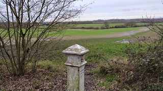
The "Chessington Countryside Walk" is a local authority promoted walk which loops around Horton Country Park, Epsom and Ashtead Commons, and Winey Hill (viewpoint). A lovely summer walk close to London, its very muddy in winter. Anti clockwise from Chessington station
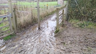
The first third of the walk is almost impassable after wet weather in winter, with lots of muddy ground water. The remainder of the walk is mainly on all weather paths. The walk passes a major attraction, Chessington World of Adventures (a Theme Park with a Zoo). Unfortunately no wild animals are visible from the footpaths as the zoo is surrounded by tall leylandii trees. There might be views from the north side of Winey Hill if you descend through the trees, but the animals are away on the far side, by the resort hotels. |
| Options |
Chessington North endingAt alternate ending, about 1km longer, that passes 2 pubs. It passes Castle Hill Nature Reserve (marked on the OS map). Just a small wooded hill, no castle (it was a manor house anyway), only some earthworks remain. |
| Wild Animals |
I had hoped to be able to warn you, that while its illeagal to keep dangerous animals in fields with public footpaths, to use common sense and not walk between a lioness and her cubs. Alas, the animals are not visible from the walk or any public footpath. Your best hope is the outside tables at the Zafari bar and Grill in the Chessington Safari hotel (with resort hotel prices). Chessington is more about the rides nowadays than the zoo. |
| Wet weather | Very muddy in winter after prolonged periods of rain. Wear waterproof boots |
| Eat |
|
| Notes |
Horton Country Park (wikipedia, Friends of) has a golf course and horse riding centre. Much of it is open land and left as a Nature Reserve. Part of it was the grounds of a former hospital with a (closed) railway line. Ashtead Common (managed by the Corporation of London for all Londoners) and Epsom Common (a local Nature Reserve) together make a single large green space in south west London. Usually quiet, they are worth exploring further if you have extra time. Neither has much of a website. |
| Profile | |
|---|---|
| Help Us! |
After the walk, please leave a comment, it really helps. Thanks! You can also upload photos to the SWC Group on Flickr (upload your photos) and videos to Youtube. This walk's tags are: |
| By Train |
Out (not a train station) Back (not a train station) |
| By Car |
Start KT9 2JR Map Directions |
| Amazon | |
| Help |
National Rail: 03457 48 49 50 • Traveline (bus times): 0871 200 22 33 (12p/min) • TFL (London) : 0343 222 1234 |
| Version |
Apr-24 Andrew |
| Copyright | © Saturday Walkers Club. All Rights Reserved. No commercial use. No copying. No derivatives. Free with attribution for one time non-commercial use only. www.walkingclub.org.uk/site/license.shtml |
