Chingford Circular walk
Varied undulating route through commons, ancient woods and wildflower meadows, with fantastic views of London Skyline and Lea Valley.
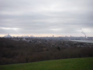
London Skyline from Yates' Meadow
SWC Short Walk 58 - Chingford Circular
Jan-24 • thomasgrabow on Flickr
swcwalks short58 banner 53495737635

Pollarded trees, Bury Wood
SWC Short Walk 58 - Chingford Circular
Jan-24 • thomasgrabow on Flickr
swcwalks short58 walkicon 53494431432

Connaught Water
SWC Short Walk 58 - Chingford Circular
Jan-24 • thomasgrabow on Flickr
swcwalks short58 walkicon 53495736960

Yates' Meadow from residential lane
SWC Short Walk 58 - Chingford Circular
Jan-24 • thomasgrabow on Flickr
swcwalks short58 walkicon 53495320516
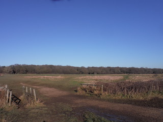
Views across the Chingford Plain
SWC Short Walk 58 - Chingford Circular
Jan-24 • thomasgrabow on Flickr
swcwalks short58 53495321796
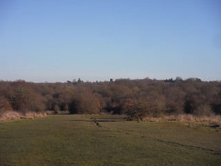
Northesasterly views across the Chingford Plain to the Forest
Jan-24 • thomasgrabow on Flickr
swcwalks short58 53495321771
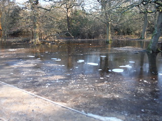
Frozen water just off path by Connaught Water (recce walk)
SWC Short Walk 58 - Chingford Circular
Jan-24 • thomasgrabow on Flickr
swcwalks short58 53495737540
| Length |
7.6 km/4.7 mi, with 109m ascent/descent and 1 ¾ hours net walking time. |
|---|---|
| Walk Notes |
A varied and undulating route through commons, ancient woods and wildflower meadows, with plenty of fascinating trees as well as fantastic views to Central London and across the Lea Valley. You leave Chingford into the Chingford Plain, heading for the main body of Epping Forest, where you cross Cuckoo Brook, the main tributary of the River Ching and then the Ching itself, before rounding most of the artificial lake of Connaught Water. Follow a meandering route along forest paths, tracks and rides through the very interesting ancient treescape, dominated by ancient, often pollarded oak and hornbeam, including stretches along the Upper Ching River and through the valley of the meandering Cuckoo Brook.
|
| Walk Options |
Cut the loop around Connaught Water (cut 750m).
|
| Eat & Drink |
Station Road is full of bars, cafés, restaurants and takeouts, but only some of them are close to the station. Passed on the optional loop through town (adds 700m) are: The King’s Head pub, The Wine Factor wine bar, Dada Café, Las Tapas, La Baita and Trattoria Ibleo (Italian), Pat Pong (Thai), Bar Sicilia.
|
| Transport |
Start & Finish: Chingford Overground Chingford Station is one of the northern termini of the Lea Valley lines from London Liverpool Street, serving Chingford, Cheshunt, Enfield Town and Hertford East. The Chingford line is operated by London Overground and the station is in Travelcard Zone 5. The journey time is from 27 minutes. |
| Notes |
Chingford and Chingford Station Chingford is a town and London suburb of about 70,000 population within the Borough of Waltham Forest. Waltham Forest Borough was created in 1965 by merging Chingford with Walthamstow and Leyton.
Chingford Station opened in 1873 as a gateway to Epping Forest. Built initially closer to Chingford’s centre and as a temporary terminus in light of plans to extend the line to High Beach in the centre of the Forest, those plans were scrapped as the Forest got protected status and instead the station was moved to the northern edge of town, much to the inconvenience of residents nowadays. Epping Forest Epping Forest is an area of ancient woodland and other habitats like grassland, heath, streams, bogs and ponds, which straddles the border between London and Essex. Stretching for 19 km (12 mi) from Manor Park in East London north to Epping, with the main body of the Forest being north of Chingford, it is never more than 4 km wide, and in most places considerably narrower. It lies on a low ridge between the Lea and Roding Valleys which were formed by arms of the Scandinavian ice sheet during the last glacial period, around 18,000 BC. It is London's largest forest and largest Open Space at 2,400 hectares (5,900 acres).
River Ching The Ching is a 9.5 km (6.0 mi) tributary of the River Lea (or Lee) and originates as a small stream from a seep at the foot of a tree in the southern part of Epping Forest (this can be seasonal). It flows through woodland to the artificial lake Connaught Water. The Water was created by damming the Ching to provide an outlet for drainage measures in the formerly swampy Fairmead area of Epping Forest.
The name of the river is a back-formation from Chingford, rather than the town being named after the river. |
| Profile | |
|---|---|
| Help Us! |
After the walk, please leave a comment, it really helps. Thanks! You can also upload photos to the SWC Group on Flickr (upload your photos) and videos to Youtube. This walk's tags are: |
| By Train |
Out (not a train station) Back (not a train station) |
| By Car |
Start E4 6AL Map Directions |
| Amazon | |
| Help |
National Rail: 03457 48 49 50 • Traveline (bus times): 0871 200 22 33 (12p/min) • TFL (London) : 0343 222 1234 |
| Version |
Jun-24 Thomas G |
| Copyright | © Saturday Walkers Club. All Rights Reserved. No commercial use. No copying. No derivatives. Free with attribution for one time non-commercial use only. www.walkingclub.org.uk/site/license.shtml |

Walk Directions
Full directions for this walk are in a PDF file (link above) which you can print, or download on to a Kindle, tablet, or smartphone.
This is just the introduction. This walk's detailed directions are in a PDF available from wwww.walkingclub.org.uk