Colliers Wood to Putney Bridge (Wandle Trail) walk
River Wandle Trail and the Thames Path
Colliers Wood to Putney Bridge
swcwalks short25 putney london walkicon 36839756321

Colliers Wood to Putney Bridge
swcwalks short25 collierswood london 36839748301

Colliers Wood to Putney Bridge
swcwalks short25 collierswood london 36808676432

Colliers Wood to Putney Bridge
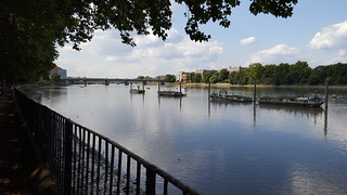
swcwalks short25 putney london 36839753571
| Start | Colliers Wood tube station | ||
|---|---|---|---|
| Finish | Putney train station or Putney Bridge tube station | ||
| Length |
5.5 miles (8.8 km) | ||
| Toughness |
Easy | ||
| Time | 1 hour 45 minutes. | ||
| Walk Notes |
This walk follows the last 4 miles of the River Wandle Trail in south west London to the River Thames, then follows a pretty stretch of the Thames Path through Wandsworth Park to Putney. The walk finishes at a large riverside pub, with options to continue along the Thames Path or explore 2 more riverside parks. To be fair, the Wandle Trail isn't the prettiest of walks, but it is a convenient stroll to nice (Thames) riverside parks and pubs for south west Londoners. The Wandle Trail section is a mix of paths alongside a narrow river, small urban parks and open spaces (some nice, some unkempt) passing back gardens and some industrial areas. The Trail is waymarked, but mainly for cyclists (blue signs with a water wheel for cyclists, green signs with a water wheel for walkers). The route is being improved over time as former industrial areas are gentrified. The river has an interesting industrial heritage, it has a very steep gradient, so it was channelled to drive water wheels, now the route's symbol. This section passes Earlsfield and Wandsworth, both have train stations and shopping areas. The Thames path section is much more picturesque, with a wide riverside promenade, and an urban park with an avenue of trees. At Putney Bridge, there are two riverside pubs, suitable for groups, with a terrace. Putney Bridge has a church at either end - St Mary's (Putney) (busy community cafe) on the southbank, and All Saints (Fulham) on the north bank. Both are free to visitors when open - just try the door. On the south side of the bridge is Putney (rail) station. On the north side is Putney Bridge tube station. Bishop's Park and Fulham PalaceAcross the bridge on the north bank, just past All Saints Church, are a Palace and 2 riverside parks. Fulham Palace and Park (free entry), used by the Bishops of London from the 11th C until 1973, is a historic building with gardens, a small museum and art gallery, and a cafe with a garden terrace. The building, gardens, and grounds were neglected in the 20th C. Now run by a Trust, it is currently being restored. Next to it is Bishop's Park, with an urban beach, and a cafe by the children's play area. Pryors Pavilion (the grand Tudor style riverside building next to All Saints Church) is not open to the public - its currently church offices. Extend the walkYou can follow the Thames Path along the north or south banks on to Hammersmith, the next bridge. Don't walk back towards central London along the north bank - there's a long inland detour. | ||
| Updates | Nov-2023:
| ||
| Travel |
Colliers Wood is near the bottom of the Northern Line in Zone 3. Putney Bridge is on the District Line. On the south side of Putney Bridge is Putney station (trains to Waterloo). On the north side is Putney Bridge tube station (District Line). For drivers, Colliers Wood has (mostly) free parking at weekends, and after 6:30 weekdays. Regular buses return from Putney to Tooting Broadway. From there, it's either 1 tube stop, a 1 km walk, or a bus. | ||
| Eat |
Colliers Wood
|
| Profile | |
|---|---|
| Help Us! |
After the walk, please leave a comment, it really helps. Thanks! You can also upload photos to the SWC Group on Flickr (upload your photos) and videos to Youtube. This walk's tags are: |
| By Car |
Start SW19 2HR Map Directions Finish SW6 3UH Map Directions |
| Amazon | |
| Help |
National Rail: 03457 48 49 50 • Traveline (bus times): 0871 200 22 33 (12p/min) • TFL (London) : 0343 222 1234 |
| Version |
Apr-24 Andrew |
| Copyright | © Saturday Walkers Club. All Rights Reserved. No commercial use. No copying. No derivatives. Free with attribution for one time non-commercial use only. www.walkingclub.org.uk/site/license.shtml |

Walk Directions
Colliers Wood to Earlsfield
- Exit Colliers Wood tube station, cross the main road, and follow the pedestrian road with the Charles Holden pub on your left. You are now on the Wandle Tail, which you more or less follow to the Thames. NB: The Wandle Trail has just been re-routed here, so isn't as shown on older maps.
- Enter Wandle Park NT. Continue ahead. Cross a railed wooden bridge, where the path curves to the left, and a little later, cross a second small wooden bridge.
- Easy Option Turn right and head towards the children's play area. Exit the park, and turn right on Byegrove Road, then, in 50m, at a road junction, turn left on a walk/cycle path. Follow it north for 500m, with houses on your right, and soon, a nature park on your left. Continue ahead, crossing North Road. Eventually, you come to a railway bridge.
- Complex Option (Map or GPS advised) Continue ahead, and leave the park, crossing the Wandle. Turn right, following the river. In 25m, a road crosses the Wandle by an old Mill building. Continue ahead to follow the riverside path. Cross a footbridge to the right bank. Cross a road (North Street), head north, then north east (veering right, away from the river bank), eventually joining a tarmac walk/cycle path. NB: Do not follow the riverside path - it peters out soon after a footbridge, becomes overgrown, and is eventually blocked by a railway line.
- The tarmac path goes under a railway bridge. In 50m you rejoin the river bank.
- In 300m, at the next bridge (Plough Lane, a main road), cross to the left bank
- In 1km, at the next bridge (Trewint Street), there is a new development with the Louis Earlsfield restaurant, and beyond a few picnic tables. There are plans to build a riverside bridge under the railway line, but for now, you have to detour away from the river.
Earlsfield
- Turn right along Trewint Street (a lane) and cross the bridge over the Wandle.
- Leaving the river path, turn left on Summerley Street.
- In 200m, you reach Garett Lane and Earlsfield town centre (shops, cafes, pubs). Just to your right is St Andrew's Church which has the nice Home Community Cafe. (weekdays only)
- Turn left on Garett Lane. Pass Earlsfield station.
- In 75m turn left on Penwith Road. This road crosses over the Wandle.
- This section is new. In 50m, take the first right on to Strathville Road. Continue straight on to cross the river again (now Duntshill Road). At the right hand bend, turn left on Flock Mill Place, and in 5m, continue straight on (leaving the road) on a footpath passing under a building overhanging the river.
- After crossing the river, turn right along the riverside path (Riverdale Drive) on the other side. You have new apartment blocks on your left, and soon enter King George's Park.
Earlsfield to the Thames
- Follow the path through the park, with the Wandle on your right. Cross Kimber road, and continue through the park. The path leaves the Wandle and veers left.
- Turn right at a three-way junction and then pass a fenced lake to its left. The back of the Southside Shopping centre is to your right (Waitrose, Decathlon, cafes).
- At the north end of the park, turn right on Buckhold Road. You soon reach the busy Wandsworth 1-way system.
- This section is new. Cross the busy road, and then cross the Wandle on a footbridge. Turn left to follow the river past the Young's Brewery redevelopment. [Mar-19] This section is likely to change. Currently you have to walk around some boarded up old Mews houses (i.e., 3 sides of a square). Turn right, and follow the hoarding. Turn left, and cross the busy road (the other side of the 1-way system) at the lights. Turn left again, and walk back to the Wandle.
- Turn right on to a lane (The Causeway), alongside the Wandle. Follow the river past an industrial area (one of the Tideway building sites, London's 'Supersewer'), and under a railway line.
- You meet the Thames Path (you can continue on for 25m to the very end of the Wandle Trail, but it's a dead end).
The Thames Path to Putney
- Turn left (west) on the Thames Path to cross a bridge over a dock.
- When the residential development is finished, you will turn right here to meet the Thames, but for now skirt around the outside of the building site. Join Enterprise Way. First right on Osiers Road. Continue ahead through the residential area (past the strategically placed planters that make it appear to be private) to the Thames. Turn left (west) along the riverside path.
- Enter Wandsworth park. At its far end, the Thames path leaves the river. Go through a wide pedestrian gate about 40m inland to enter Blade Mews. At its end, continue in the same direction along Deodar Road. Pass under a railway bridge (with a footbridge - it leads to Putney Bridge tube station). At the end, the road curves right towards the river. Continue along a lane for 20m to rejoin the Thames
- In 75m, you come to a slipway down to the riverbed, The Boathouse pub/restaurant, and The Rocket pub (a Wetherspoon's).
- Just past the pubs is St Mary's Church, Putney Pantry cafe, and Putney Bridge.
- To return to Colliers Wood : turn left on Putney Bridge Road, then left again to a bus stop. Catch a bus to Tooting Broadway. Alight by the tube station. From there, either walk 1km along the A24 (passing Sainsburys at the start), or go 1 stop on the tube, or catch a frequent bus from outside Sainsburys, back to Colliers Wood.
- To continue walking : follow the Thames Path along the south bank for 2.5 km to Hammersmith Bridge. Cross the bridge. From there it's 500m to Hammersmith tube.
Putney Bridge, Bishop's Park and Fulham Palace
- Cross the bridge. Turn right on Gonville Garden for Putney Bridge tube station.
- Or, to explore the Palace and Park, cross the road to All Saints Church.
- Walk through the churchyard, and visit the church (free entry). Exit on the far side of the churchyard, through a pedestrian gate into Fulham Palace park.
- Pass the walled garden to reach the main Palace building. Enter the palace via its cafe, and walk through it (free entry).
- Exit into Bishops Palace Park (cafe by the children's play area).
- After looking around the park, return along the riverbank to Putney Bridge, passing a mock Tudor building.