Crosby Beach - Antony Gormley's Another Place walk
Easy beach walk past Antony Gormley's public art installation “Another Place” with views of The Wirral Peninsula.
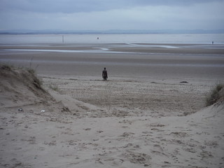
Crosby Beach: View through the dunes
SWC Short Walk 35 - Crosby Beach: Antony Gormley's Another Place
Jan-19 • thomasgrabow on Flickr
swcwalks short35 banner 46906422221

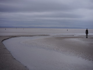
The Mountains of North Wales, and the foreshore
SWC Short Walk 35 - Crosby Beach: Antony Gormley's Another Place (Hightown Start)
Jan-19 • thomasgrabow on Flickr
swcwalks short35 walkicon 46181524404

Statue on its foundation pile
SWC Short Walk 35 - Crosby Beach: Antony Gormley's Another Place
Jan-19 • thomasgrabow on Flickr
swcwalks short35 walkicon 46854433232
Statues and the Mountains of North Wales
SWC Short Walk 35 - Crosby Beach: Antony Gormley's Another Place
Jan-19 • thomasgrabow on Flickr
swcwalks short35 walkicon 39941653963
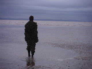
Barnacled Statue and the bubbling sea
SWC Short Walk 35 - Crosby Beach: Antony Gormley's Another Place
Jan-19 • thomasgrabow on Flickr
swcwalks short35 walkicon 39941649593

Statues and Passing Ferry
SWC Short Walk 35 - Crosby Beach: Antony Gormley's Another Place
Jan-19 • thomasgrabow on Flickr
swcwalks short35 walkicon 39941648093

The River Alt
SWC Short Walk 35 - Crosby Beach: Antony Gormley's Another Place (Hightown Start)
Jan-19 • thomasgrabow on Flickr
swcwalks short35 39941664053
| Length |
From 5.1 km (3.2 mi) to 7.2 km (4.5 mi), depending on tide and appetite for walking on sand.
Time: 1 1/4 hour or 1 3/4 hours walking time. |
|---|---|
| Transport |
Hall Road, Waterloo and Hightown stations are located on the Southport branch of the Merseyrail network's Northern Line, travelling north along the West Lancashire Coast.
|
| Walk Notes |
Fascinating, easy walk in Merseyside, from Hall Road to Waterloo stations and along Crosby Beach past Antony Gormley's world-renowned public art installation "Another Place" in its now permanent location, with views across the Mersey Estuary to The Wirral Peninsula and across Liverpool Bay to the North Wales mountains.
Note: The statues are placed on Crosby Foreshore, a wide and shallow tidal beach on the River Mersey, which has the second highest tidal range in Britain. Therefore plenty of water channels with fast-moving water and large areas of very soft sand and mud exist. And while it is generally safe within 50m of the promenade, further out it is easy to get cut off by the incoming tide or to get stuck in soft sand or mud. There are also often nesting birds near the Low Water mark (as shown on the route map). In any case, study the tide times before embarking on this walk, and - if in doubt - stick to the High Water mark (as shown on the route map) or even to the tarmac promenade at the back of the beach. |
| Eat/Drink |
Plenty of options near Waterloo station, see text below for details. |
| Notes |
River Alt The River Alt is Liverpool's second river and flows north west through Lancashire and Merseyside. It rises in Huyton at the Hag Plantation, and flows through Croxteth Park, West Derby and Maghull. It then flows out to the River Mersey at Hightown, between Crosby and Formby. St Helens Gutter, as the Alt is known between Aintree and Maghull, was once the name of the Milldam (water supply) of Sefton Mill. The river flows through a channel created around 14,000 years by glacial ice which crawled south from the Irish Sea basin. As the Alt flows towards the coast, it cuts through a plain of alluvium (river or wind deposited sand), mudstone and sandstone. At its mouth are the wide beaches and quicksand of the West Lancashire coast. For generations, people have had to fight against the Alt flooding. Today the Alt valley is a protected nature reserve. Thirty kilometres of embankments protect the farmland which lies either side. Antony Gormley's "Another Place" Crosby Beach, Merseyside now is the permanent home of Antony Gormley's art installation "Another Place". It consists of 100 figures of cast iron facing out to sea, "staring" at the horizon in "silent expectation". They are spread over a 3.2 km (2.0 mi) stretch of the beach between Waterloo and Blundellsands, and stretch out almost 1 km to the sea from the coast line. Each figure is 189 cm tall, weighs around 650 kg and stands on a metre-high foundation pile. The figures are cast replicas of Gormley's own body. As the tides ebb and flow, the figures are revealed and submerged by the sea, or - in the artists's words - "In this work, human life is tested against planetary time.". As a result, regular maintenance is needed to check the changes wrought by heavy winter storms and shifting sands. The figures were cast at Hargreaves Foundry in Halifax, West Yorkshire and the Joseph and Jesse Siddons Foundry in West Bromwich. Over the years, the statues have been colonised by sessile intertidal organisms, such as invasive species of barnacles.
Waterloo Waterloo is a residential suburb of predominately Georgian, Edwardian and Victorian villas, mews and terraces, facing the sea. A series of public gardens - built as a job creation scheme during the 1930s Great Depression - run adjacent to the esplanade that abuts the marina leading to the coast and beach.
|
| Profile | |
|---|---|
| Help Us! |
After the walk, please leave a comment, it really helps. Thanks! You can also upload photos to the SWC Group on Flickr (upload your photos) and videos to Youtube. This walk's tags are: |
| By Train |
Out (not a train station) Back (not a train station) |
| By Car |
Start L23 8TU Map Directions Return to the start: Finish L22 0LY Map Directions Travel to the start: |
| Amazon | |
| Help |
National Rail: 03457 48 49 50 • Traveline (bus times): 0871 200 22 33 (12p/min) • TFL (London) : 0343 222 1234 |
| Version |
Apr-24 Thomas G |
| Copyright | © Saturday Walkers Club. All Rights Reserved. No commercial use. No copying. No derivatives. Free with attribution for one time non-commercial use only. www.walkingclub.org.uk/site/license.shtml |


Walk Directions
Hightown Start
Directions last checked: 06/03/2024
- Arriving from Liverpool, leave the platform at the southerly end towards the back of the train, ignore the overbridge across the tracks to the station building and exit the station to the right along a tarmac path and in 20m continue along Alt Road, with The Hightown pub on the left.
- In 15m fork right along Lower Alt Road, gently curving to the left with it. In 120m at a large roundabout with a War Memorial in the middle, cross over to the memorial and pass it to either side and continue in the previous direction, still along Lower Alt Road.
- In 150m, where the road turns sharp left and continues as 'Riverside', you continue in the same direction along a tarmac cul-de-sac past a 'MOD Property - No Parking'-sign. In 50m you reach a T-junction with a the signed England Coast Path (ECP) on the banks of the River Alt with the Altcar MOD Ranges beyond it. Turn left along the Sefton Coastal Path, initially on tarmac.
- In 50m continue to the right of a fenced utility building along an earthen path, signed 'Hall Road Station 1 3/4 miles'; 'Waterloo Station 4 1/4 miles'. You have the river on your right and in 20m the fence turns to the left. In 40m you pass an info panel on 'Hightown and the Alt Estuary'.
- In 50m the river turns away to the right and you get first views of North Foyle Wind Farm, the UK's first major offshore wind farm, as well as of the distant mountains of North Wales (weather permitting). You have trees and the houses of Hightown on the left and some reed beds on the right.
- In 50m you pass the first of several ECP and footpath marker posts and in another 160m ignore a right fork towards the beach out of sight to the right, just before entering an area of dunes.
- The now sandy path meanders through a grassy area between dunes on the right and gardens on the left, and in 120m you cross a path from a residential road away to the left. In 100m pass a marker post and in 120m another one. In another 40m you have views on the right out to sea, by another marker post.
- You pass two more marker posts and in 130m reach a wide turning circle at a T-junction with a drive from the left, by Blundellsands Sailing Club on your right. At low tide, a path hard right back on yourself and signed 'Beach' and 'Submerged Forest' is worth exploring.
- There is an info panel on 'Prehistoric Altmouth' on the right. Cross the turning circle and continue in the previous direction to the left of a footpath marker post along a broad sandy track, ignoring a signed path to the right into the dunes.
- In 50m fork right with a marker post, keeping close to the dunes and beach, ignoring a left fork heading towards the last houses of Hightown, and in 100m fork left with a marker post, away from the dunes. In 35m bear right along a path joining from the left behind.
- In 100m cross a path at a marker post and continue in the same direction, when level with the last houses away on the left. You are walking along an earthen path now for 160m where you re-enter sand dunes by a marker post. In 50m the path turns to the right with a marker posts and in another 60m it turns left again with another one.
- In 15m bear right with a marker post and in 90m you get to a junction with a wide tarmac path at a bend. This is Route 810 of the National Cycle Network, also signed as the 'Sefton Circular' and a shared foot/cyle-path. Turn right along it, although there are walkable grassy margins on either side.
- In 150m there is a clear footpath about 20m to the right in the grassy area close to the cliff face.
- Soon you have the (fenced off) West Lancashire Golf Club away on the left and after 500m you pass a large red brick building on the left, presumably a pumping station for the underground drain emptying from inland marshland into the River Alt on the right, which bears right here from the cliff coast, away to join the Mersey.
- The Wirral Peninsula has now come into view across the Mersey River, as well as some of Liverpool's Docks on this side of the Mersey (weather permitting). In 1.0 km you pass a two-way signpost for the King Charles III England Coast Path, go through a squeeze gate to the right of a metal car gate and pass a Coastguard Station on the left, while walking through a car park.
- In 110m Promenade (road) joins from the left. This is a continuation of Hall Road and the main walk route from Hall Road station joins along it. On the right along Crosby Beach are the first of Antony Gormley's statues visible on the sandy foreshore. The Wirral Peninsula and some of Liverpool's Docks are visible to the half-right, and - on a good day - the mountains of North Wales in the distance beyond it.
- Turn right towards a large info panel on Another Place and pick up the directions below at number [4].
Hall Road Start
Directions last checked: 06/03/2024
- Arriving from Liverpool, leave the platform at the southerly end towards the back of the train and turn right along Hall Road West.
- In 500m you continue in the same direction along Promenade where the main road turns to the left as Burbo Bank Road North, to a large car park ahead by a Coastguard Station on the right.
- Where the tarmac lane ends, a wide tarmac path joins from the right, this is Route 810 of the National Cycle Network and the Hightown Start joins along it. You have Crosby Beach in front of you, with the first of Antony Gormley's statues visible on the sandy foreshore. The Wirral Peninsula and some of Liverpool's Docks are visible to the left, and - on a good day - the mountains of North Wales in the distance. Walk towards a large info panel on Another Place.
- Turn left from the info panel, go down a slipway onto the beach and find your way south past or through the 100 statues. The upper part of the beach should be safely walkable in all but the worst storms and the Mean High Water mark is marked on the route map as the main walk route. The alternative route follows the Mean Low Water mark and you should stay clear of that area - even at low tide - to protect the birdlife there.
- The beach is 3.5 km long and Gormley's statues are placed all the way along it, but the recommended exit from the beach comes about 600m before its end. This is about level with a beacon out to the right on the Mean Low Water line and near the shipping lane of the River Mersey.
- You leave the beach through some dunes onto the tarmac promenade at the back of the beach and (if you have picked the right spot to do so) come out at a signposted three-way junction of paths (although these may be part-blown over with sand from the surrounding dunes).
- Follow the Sefton Coastal Footpath turning away from the beach in a broadly easterly direction towards a body of water visible inland and in 140m you walk between two lakes: the narrower Boating Lake on the left, and the much larger Marine Lake on the right (both on the OS map).
- In 260m ignore a right fork and in another 90m a path joins from the left.
- In 150m - at a signposted multi-path junction - you turn left (signed 'South Road Shops 10 mins') between a row of low cafés and shops on the left and the walled Waterloo Seafront Garden on the right (the entrance is 50m ahead). You pass Crosby Marina Kiosk and the Waterloo Sunset Café and cross a main road (Marine Crescent/Terrace) to continue down South Road.
- It is 350m to Waterloo Station, and en route you pass: several restaurants, Marine Bar & Kitchen, The Raven Hotel, The Old Bank, The Queen's Picture House (Wetherspoon's), The Alexandra and Parnell's.
- If you were to continue down South Road for another 250m, you'd also find Trap & Hatch Micropub & Smoke House and The Liver (Hive Pubs/Greene King).