Dagenham Parks, Rivers and Ponds Short Walk
Exploration of several linked green areas in an otherwise densely populated suburb: a large variety of landscapes in Country Parks and Nature Reserves

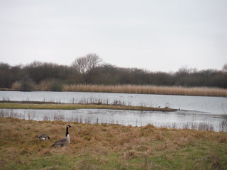
Pond by Wantz Stream, Beam Parklands
SWC Short Walk 33 - Dagenham Parks, Rivers and Ponds
Feb-18 • thomasgrabow on Flickr
swcwalks short33 walkicon 25708334807

Grassy Path through Gorse Bushes, Beam Parklands
SWC Short Walk 33 - Dagenham Parks, Rivers and Ponds
Feb-18 • thomasgrabow on Flickr
swcwalks short33 walkicon 26707068708

Through Reed, Beam Valley Country Park
SWC Short Walk 33 - Dagenham Parks, Rivers and Ponds
Feb-18 • thomasgrabow on Flickr
swcwalks short33 walkicon 26707054158
The Slack (Bird Sanctuary), The Chase Local Nature Reserve
SWC Short Walk 33 - Dagenham Parks, Rivers and Ponds
Feb-18 • thomasgrabow on Flickr
swcwalks short33 walkicon 38768666470

Millenium Centre, Eastbrookend Country Park
SWC Short Walk 33 - Dagenham Parks, Rivers and Ponds
Feb-18 • thomasgrabow on Flickr
swcwalks short33 walkicon 40536255002
| Start & Finish | Dagenham East Underground Station |
|---|---|
| Length | 10.1 km/6.3 mi. Ascent: negligible. Time: 2 ¼ hours |
| Travel |
Dagenham East Underground Station is in Zone 5, on the District Line to Upminster. Journey time from Aldgate East is 32 minutes, from Victoria 49 minutes. You can shave off a few minutes by taking mainline trains from Fenchurch Street (or from Limehouse or West Ham) to Barking for part of the journey. |
| Features |
This is an exploration of several linked green areas in an otherwise densely populated East London suburb, leading through some Local Nature Reserves, two Country Parks, an ex-landfill site and ex-quarry, a river floodplain and along the recently restored beds of the Wantz Stream and the Beam and Rom Rivers. This walk has a large variety of landscapes, from acid grassland, fenland and woodland to marshland and sandy shrubland via woods and a tranquil meandering valley. Beam Parklands provides functional flood prevention and public open space for the community, while the Beam Valley Country Park was formerly derelict land after having been partly worked for gravel, leaving a wide diversity of habitats, with wet and dry grassland, tall herbs and scrub, and one small area of willow woodland, a scarce habitat in London. The Chase Local Nature Reserve has large areas of marshland and contains 6 of only 600 mature female Black Poplar trees left in the UK as well as a fenced off Bird Sanctuary (The Slack). Eastbrookend Country Park, now an interesting, undulating landscape, was formerly a gravel quarry then a dumping ground for the rubble left over from the blitz. A shortcut at the northerly end of the walk reduces the length by 2.3 km. |
| Eat |
|
| Notes |
Beam Parklands Beam Parklands is a 53 hectare site which provides functional flood prevention and public open space for the community. The site is a floodplain of the River Beam and is used for flood storage, protecting homes, businesses, schools and the nearby Barking power station (which supplies 1/3 of London’s power). Archaeological excavation of Beam Parklands discovered that the site had previously been used in the late Iron Age and Roman era for settlement and to manufacture pottery. Later the site was the origins of Dagenham which sprawled out from these early Saxon developments, which were also one of the earliest in Essex. It was used for wide scale agricultural purposes throughout history and resulted in the construction of a windmill next to the river (no longer standing). In 1894 West Ham County Borough Council purchased the Rookery Farm in the area as a site for a smallpox hospital, which opened in 1899. It consisted of single-storey brick buildings surrounding a quadrangle. [The quadrangle of trees is still on site today and surrounds the mound in the centre of Beam Parklands.] In 1912 the smallpox hospital was converted into a TB hospital and renamed the Dagenham Sanatorium, later Dagenham Hospital, but remained a specialist TB hospital. In 1980 it had become a geriatric hospital and in 1989 it closed for good and was subsequently demolished. The site was then badly neglected for many years and became a magnet for anti-social behaviour before the Land Trust took it on and opened it up to the public in 2011. Now Beam Parklands is the newest park in Dagenham with a variety of habitats including grassland, fenland and woodland along the recently restored parts of both the Wantz stream and the River Beam, while also providing flood storage washland (holding 450,000m3) & improved flood banks. Open daily till dusk. https://thelandtrust.org.uk/space/beam-parklands/ Romford Canal The first of many proposals for the Romford Canal was made in 1809 although construction work did not commence until 1875 and then only to cease permanently 2 years later after the company was unable to raise sufficient capital to complete the work. In the early 19th century the Romford area was one of the main sources of potatoes for the London market and a canal was proposed from the Thames to Romford and Collier Row to take the crops into London and bring back manure on the return journey. Surprisingly, in 1875, at a time many when many canals had already closed or were closing under the threat of railway competition, an act was obtained for the construction of a canal to Romford. Part of the canal had been used for WWII defences and was infilled soon after the war. Remnants of tank traps and pillboxes can still be seen though only very limited evidence of the former canal has survived. River Rom/River Beam The River Rom, also known as the River Beam below its confluence with the Ravensbourne, is a tributary of the Thames that flows through east London suburbs. Starting in Essex, the Rom is the continuation of the Bourne Brook after Bournebridge, Stapleford Abbotts in the Epping Forest which rises 5 km northeast in Brentwood. Throughout the northern section, its valley has been designated as a Site of Importance for Nature Conservation. It then takes an almost straight south-flowing course and further downstream in the Beam Valley is a mixture of woodlands, acid grassland, ponds and marsh areas, a habitat for many types of wildlife. The Boroughs of Barking and Dagenham and of Havering plan to develop the area to further improve the conservation interest and to create new opportunities for recreation and education. The River Beam is home to the water vole, while the grassland in the valley includes rare and endangered plants. Rom is a back-formation from the name of the town of Romford, which is located on a crossing of the river. The name 'Romford' is first recorded in 1177 as Romfort, which is formed from 'rūm' and 'ford' and means "the wide or spacious ford". The name of the river is first recorded in the 13th century as le Markediche, meaning 'boundary ditch' and referring to the ancient boundary between the parishes of Dagenham and Hornchurch. A more recent name for part of the river of the Beam originated from an early bridge over the river, consisting of a beam of wood and first mentioned in 1299. Beam Valley Country Park Beam Valley Country Park is a 74 hectare park in Dagenham. Most of it is designated as a Local Nature Reserve (LNR) called Beam Valley. The park was formerly derelict land after having been partly worked for gravel, leaving a wide diversity of habitats, with wet and dry grassland, tall herbs and scrub, and one small area of willow woodland, a scarce habitat in London as well as the River Beam and the Wantz Stream. Birds found on the site include kingfishers, reed warblers, reed buntings and skylarks. There is archaeological evidence that the site has been used since the Stone Age, and it also has a Roman pottery kiln. Eastbrookend Country Park & The Chase Local Nature Reserve From the 1920's to the 1960's the area was a gravel quarry, then through to the 70's, it was used as a dumping ground and filled with the rubble left over from the blitz. The creation of Eastbrookend Country Park started in the 1990s with large scale earth moving and tree planting to develop an interesting, undulating landscape. The park officially opened in 1995. The Chase Local Nature Reserve contains 6 of only 600 mature female Black Poplar trees left in the UK. An area called The Slack is fenced off to ensure that the birds and wildlife are not disturbed. |
| Profile | |
|---|---|
| Help Us! |
After the walk, please leave a comment, it really helps. Thanks! You can also upload photos to the SWC Group on Flickr (upload your photos) and videos to Youtube. This walk's tags are: |
| By Car |
Start Map Directions |
| Amazon | |
| Help |
National Rail: 03457 48 49 50 • Traveline (bus times): 0871 200 22 33 (12p/min) • TFL (London) : 0343 222 1234 |
| Version |
Aug-22 Thomas G |
| Copyright | © Saturday Walkers Club. All Rights Reserved. No commercial use. No copying. No derivatives. Free with attribution for one time non-commercial use only. www.walkingclub.org.uk/site/license.shtml |


Walk Directions
Full directions for this walk are in a PDF file (link above) which you can print, or download on to a Kindle, tablet, or smartphone.
This is just the introduction. This walk's detailed directions are in a PDF available from wwww.walkingclub.org.uk