Hampton Court and Bushy Park walk
2 deer parks and a royal palace


| Start | Hampton Wick station |
|---|---|
| Finish | Hampton Wick station |
| Length |
7km. |
| Time | 2 hours |
| Travel | National Rail. Hampton Wick is in Travelcard Zone 6 and part of the Kingston Loop line with trains from Waterloo. (The loop section via Wimbledon is the shorter journey time.) |
| Walk Notes |
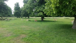
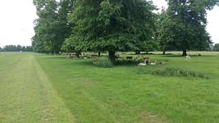
Through Hampton Court and Bushy Parks. This walk is best avoided from mid June to mid July. (The Hampton Court Flower show which is held in early July, necessitates large sections of Hampton Court Park being blocked off for the two weeks prior, during and at least one week after the show.) |
| Eat |
The Foresters, 45 High Street KT1 4DG T: 020 8943 5379. Food served until 22:00. |
| Profile | |
|---|---|
| Help Us! |
After the walk, please leave a comment, it really helps. Thanks! You can also upload photos to the SWC Group on Flickr (upload your photos) and videos to Youtube. This walk's tags are: |
| By Train |
Out (not a train station) Back (not a train station) |
| By Car |
Start KT1 4DQ Map Directions |
| Amazon | |
| Help |
National Rail: 03457 48 49 50 • Traveline (bus times): 0871 200 22 33 (12p/min) • TFL (London) : 0343 222 1234 |
| Version |
Apr-24 DAC |
| Copyright | © Saturday Walkers Club. All Rights Reserved. No commercial use. No copying. No derivatives. Free with attribution for one time non-commercial use only. www.walkingclub.org.uk/site/license.shtml |

Walk Directions
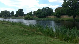
- Coming out of Hampton Wick station, turn left along the High Street. In 300 metres you reach a roundabout with Kingston Bridge off to your left. Turn right and after 30 metres, turn left (immediately before the Old Kings Head pub), through Kingston Gate into Home Park. In 70 metres go through a gate to the left of a cattle grid, and turn right along a path with Hampton Wick Pond on your right hand side, to then continue in the same direction through an avenue of trees towards Hampton Court Palace.
- Alternative possible route: Once over the cattle grid continue south for 1km to then turn right to go alongside The Long Water on your right hand side for 1km to then reach the immediate Palace Grounds.
- Depending on the time of year, as you approach the Palace there may be a charge to go through the immediate Palace Grounds. [A] Alternatively you may skirt around the Palace Grounds. [B]
- [A] Through the Palace Grounds
- Cross over a wooden bridge to enter the Palace Grounds, and veer right to pass by the Palace and Maze on your left hand side to exit via Lion Gate, and cross over the main road via a zebra crossing, to then go through Hampton Court Gate into Bushy Park. Resume the directions at the asterisk [*] below.
- [B] Skirt around the immediate Palace Grounds.
- As you approach the Palace, there is a 2.5 metre high brick wall on your right hand side. Go through the gate (Paddock Gate) in the brick wall, to follow a path through the Paddock area to come out after 200 metres, onto the main road, where you turn left. In 250 metres you reach the Lion Gate entrance on your left hand side. If you do not want to explore the grounds outside the paid for area, turn right to cross the main road via a zebra crossing, to go through Hampton Court Gate into Bushy Park.
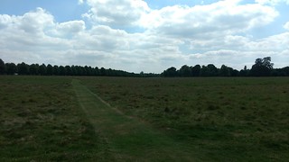
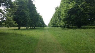
- [*] Continue in a northerly direction along an avenue towards the Diana Fountain. On reaching the fountain, turn left along Lime Avenue in a westerly direction. After 600 metres, turn right in a northerly direction to cross a brick bridge along Ash Wood, to head between two fenced in woods. After 50 metres, turn right to go through a gate, to follow the London Loop through this wood with river / ponds on your left hand side.
- In 500 metres, immediately before a footbridge off to your left, turn right (marked by a London Loop sign) through a gate to exit the wood, and turn left to continue along the London Loop in the same easterly direction. After 160 metres cross over a road, to then pass by an old water pump mounted on a brick plinth after 80 metres.
- Continue in this easterly direction along the London Loop, (the spire of St. John the Baptist in the distance, which you will pass by later on is a useful landmark - however difficult to see from a distance against background buildings. A white concertinaed block of flats just to the left of the spire is easily visible), to eventually exit through a tall black metal gate onto Church Grove Passage, a car wide tarmac track.
- In 270 metres you come out to a main road opposite St. John the Baptist Church. Cross this road, to go along the road to the left of the Church, (St. Johns Road). In 150 metres you reach The Forrester’s pub, the recommended refreshments stop. (To reach Hampton Wick station, turn left along the High Street for 100 metres.)