Harrow on the Hill walk
The playing fields of Harrow School and the historic buildings of Harrow village on its ridge
View along High Street
SWC Short Walk 40 - Harrow-on-the-Hill (South Kenton or Northwick Park to Harrow-on-the-Hill)
Apr-18 • thomasgrabow on Flickr
swcwalks short40 banner 27708593358

Central London and Wembley Stadium from (Private) Viewpoint
SWC Short Walk 40 - Harrow-on-the-Hill (South Kenton or Northwick Park to Harrow-on-the-Hill)
Apr-18 • thomasgrabow on Flickr
swcwalks short40 walkicon 41537548182

Hanging Cemetery
SWC Short Walk 40 - Harrow-on-the-Hill (South Kenton or Northwick Park to Harrow-on-the-Hill)
Apr-18 • thomasgrabow on Flickr
swcwalks short40 walkicon 27708672278
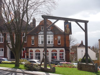
King’s Head Gantry
SWC Short Walk 40 - Harrow-on-the-Hill (South Kenton or Northwick Park to Harrow-on-the-Hill)
Apr-18 • thomasgrabow on Flickr
swcwalks short40 walkicon 27708626358

Harrow on its Hill, from the Playing Fields
SWC Short Walk 40 - Harrow-on-the-Hill (South Kenton or Northwick Park to Harrow-on-the-Hill)
Apr-18 • thomasgrabow on Flickr
swcwalks short40 40685721925

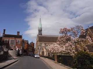
Church and Chapel on the Hill
SWC Short Walk 40 - Harrow-on-the-Hill (South Kenton or Northwick Park to Harrow-on-the-Hill)
Apr-18 • thomasgrabow on Flickr
swcwalks short40 26710056837

The contentious Tennis Courts, built over existing Right of Ways
SWC Short Walk 40 - Harrow-on-the-Hill (South Kenton or Northwick Park to Harrow-on-the-Hill)
Apr-18 • thomasgrabow on Flickr
swcwalks short40 26710043747
| Length |
5.0 km (3.1 mi) Ascent: 160m Time: 1 ½ hours walking time. |
|---|---|
| Transport |
South Kenton (Zone 4) is served by the Bakerloo Line to Harrow & Wealdstone (journey time 35 minutes from Oxford Circus) and by the Overground from Euston to Watford Junction (journey time 25 minutes). Northwick Park (Zone 4) and Harrow-on-the-Hill (Zone 5) are on the Metropolitan Line, journey time from Baker Street to Northwick Park is 17 minutes, and from Harrow to Baker Street is from 17 minutes. Harrow-on-the-Hill is also served by Chiltern Railways trains into Marylebone, journey time from 15 minutes. |
| Walk Notes |
This is a short excursion in Northwest London through a park and then the playing fields of Harrow School, one of the country's leading ‘public’, i.e. fee-paying independent schools, up onto the hill that’s dominated by the school buildings, its chapel and Harrow’s church. You walk down from the hill through the hanging cemetery and skirt around the hill to re-ascend through residential streets to the High Street, lined by historic school buildings and tea options. The walk finishes with a descent along a wood and across a grassy open space down to ‘modern’ Harrow and its busy station. A diversion to the Indian Gastro Kitchen at the Kingsfield Arms is shown on the route map. |
| Walk Options |
An Alternative Start from Northwick Park station on the Metropolitan Line is described. Buses take you from the High Street in Harrow-on-the-Hill down the hill to Harrow-on-the-Hill or Sudbury Park (Piccadilly Line) stations. |
| Notes |
Harrow School The School was founded in 1572 under a Royal Charter of Elizabeth I, and is one of the original seven public schools that were regulated by the Public Schools Act 1868. Harrow is the fourth most expensive boarding school in the Headmasters' and Headmistresses' Conference.
|
| Profile | |
|---|---|
| Help Us! |
After the walk, please leave a comment, it really helps. Thanks! You can also upload photos to the SWC Group on Flickr (upload your photos) and videos to Youtube. This walk's tags are: |
| By Car |
Start South Kenton Map Directions Finish Harrow-on-the-Hill Map Directions |
| Amazon | |
| Help |
National Rail: 03457 48 49 50 • Traveline (bus times): 0871 200 22 33 (12p/min) • TFL (London) : 0343 222 1234 |
| Version |
Apr-24 Thomas G |
| Copyright | © Saturday Walkers Club. All Rights Reserved. No commercial use. No copying. No derivatives. Free with attribution for one time non-commercial use only. www.walkingclub.org.uk/site/license.shtml |

Walk Directions
- Start from Northwick Park station: Descend some steps from the platform and turn left along an underpass, signed Northwick Park Hospital. In 25m emerge from the underpass and bear left along the furthest left of several tarmac paths through a grassy area (signed ‘Proyer’s Path’, a shared cycle-/footpath).
- You can see Wembley Stadium in the distance a little to the left and in 400m ignore a right turning concrete bridge over a ditch to a car park.
- In 180m just before a fenced playground on the left and 40m before some bollards, you turn right over a bridge across the ditch with the signposted Footpath 36 - Leading to Watford Road. Pick up the directions below at paragraph 6.
- Start from South Kenton station: Descend some steps from the platform and turn left out of the station, signed Nathans Road & Northwick Park. In 30m you pass a Capital Ring (CR) sign on a lamp post ('Greenford 5 ½')and in 25m turn right with a CR sign along a residential cul-de-sac (The Link). In 40m walk between metal bollards into a large grassy area (Northwick Park) and turn left along its left-hand boundary with a marker post.
- In 250m at a junction with a tarmac lane, turn right with a footpath sign and a CR signpost. In 180m you pass the Northwick Park car park and in 50m ignore a left turn through a hedge, signed ‘Watford Road’. In another 20m walk through some bollards and continue in the same direction along a tarmac path, with a fenced playground on the right. In 40m turn left over a bridge across a ditch with the signposted Footpath 36 - Leading to Watford Road.
- You walk through a gap to the right of a metal fence and past a footpath and Capital Ring marker post and follow the narrow, newly engineered gravel path with a wire fence on the left and trees on the right. There is a golf course behind the fence on the left and Northwick Park Hospital on the right behind the trees.
- In 360m ignore a gate in the fence on the left and continue in the same direction. In 100m ignore a signposted left turning footpath to ‘Norval Road’ and in 60m walk through a usually open metal gate by a marker post. You enter a wooded area (this can be a muddy) and in 80m curve left with the path, away from the hospital.
- In 125m cross the busy Watford Road (the A404) a little to the left uisng a median and continue in the same direction, with a ‘Footpath 58 to Peterborough Road’ signpost, through a wooden kissing gate followed by a railed duckboard, into a large grassy area.
- With Harrow-on-the-Hill visible ahead with its prominent church and chapel spires, you follow the left-hand boundary of the grassy area. In 140m pass a marker post away to the right and in 30m veer left through some younger trees towards a two-way signpost 50m away.
- Turn right at the CR signpost along a car wide gravel lane.
- In 220m cross another car wide gravel lane and in 20m turn left at a T-junction with an engineered gravel path. The path parallels the gravel lane, separated by a hedge and a fence.
- In 150m, by a four-way footpath signpost, you turn right through a gap to the right of a double wooden gate and up along a tarmac path (Football Lane) with a ‘Footpath 59 to Peterborough Road’ sign.
- On the ascent you pass various buildings belonging to Harrow School and in 150m go up some steps by a marker post and pass to the left of a metal barrier to continue in the same direction along a tarmac lane at a bend.
- In another 100m you reach Peterborough Road, the main road across the hill. From the right-hand side of Football Lane you have fine (partial) views back to Wembley Stadium and Central London.
- Turn left along the road, still uphill. In 50m turn right across teh road at a pedestrioan crossing and rigth again along Grove Hill (road) [Grove Hill was the scene of the first recorded motor accident in Great Britain involving the death of the driver, see the plaque on the right where the roads meet.] In 100m turn left up a tarmac path with a ‘Public Footpath 71 - Leading to Church Hill’ signpost.
- In 60m you reach the end of Church Hill (road) by the grand entrance to The Grove (a large house) on the right. Continue up some steps a little to the left into the churchyard of St. Mary on the Hill.
- Turn right to pass the church to its right-hand side along a paved path (passing to the left of the church hall) and turn left with the path towards a T-junction with a tarmac path. The church entrance is on the left [!] but you turn right along the path (the route passes the church again later on).
- In 30m at a T-junction with a tarmac track at the exit from the churchyard by some steep steps leading down from the hill, turn left towards some benches and a plaque, indicating Lord Byron’s Favourite Spot. There is also a toposcope on the wall on the right.
- Go back to the churchyard exit and continue in the same direction past the steps along a signposted ‘Footpath to Bessborough Road’, with the hanging cemetery on your left-hand side. The path descends gently with the cemetery on your left and there are 4 paths turning left into the cemetery. Take any of them and at the end of the path turn right downhill, with the stepped tarmac path down from the church parallel on your left.
- Leave the cemetery in its bottom left-hand corner through a gap in the growth into a grassy slope with a bench away on your right. Bear left down across the slope along a clear path towards the near left corner of the slope by some houses and to the right of a birch tree (215°).
- In 150m you turn left along a tarmac path and follow it through the houses.
- In 90m turn left up along West Street. In 70m, by The Castle pub, turn right along Crown Street. In 50m, Waldron Road turns up left. This is a Shortcut to the High Street (at the top turn left along High Street and pick up the directions at paragraph 25).
- In 200m turn left at a three-way junction along Byron Hill Road and in 140m bear left with the road, where West Hill joins from the right. In 100m you reach the top of the rise by the Old Fire Station on your right and a triangular green ahead with a large gantry on it: this is the King’s Head Gantry. [The King's Head Hotel was located in the white building on the left, see the caption at the top of the house.] You have Eightysix restaurant and bar on the left and Grove on the Hill Italian restaurant, The Connoisseur Inidian restaurant and Coffee2Cocktails bar and restaurant (on the site of a former cinema) across the green on the right.
- Turn left along High Street. In 25m Waldron Road (the Shortcut) joins from the left.
- In the next 200m the views ahead are better from the right-hand side pavement, as you pass Battels gallery, café and creperie and The Dolls House on the Hill café and then veer right with the road where West Street comes up from the left.
- In 80m [!] fork left off the High Street up along Church Hill (road).
- In 40m you have a metal gate on the left with a tarmac plateau behind it (with The Hundred Steps leading steeply down the hill on the other side). If the gate is open (this is Private Ground), you might as well turn left briefly onto the plateau for the good views to both sides of the hill, and with the Old Speech Room Gallery up on your right.
- Continue up Church Hill (road) past the original Harrow School building from 1615 (plaque on the wall) and in 70m go through the lychgate, back into the churchyard passed through earlier. Pass the church on its left-hand side past its entrance and in 50m at the far side turn right down the tarmac footpath walked along earlier, again ignoring the steps down the hill.
- This time ignore all paths to the left into the hanging cemetery and in 100m at the bottom end of the cemetery continue in the same direction along a residential road (Roxborough Park).
- In 15m turn right along a signposted footpath to Harrow, also the route of the Capital Ring, along a tarmac path with a wooden fence on the left and a wood (The Grove) on the right. In 120m you turn left with the path into the grassy Grove Open Space.
- Follow the left-hand boundary of the open space, a signposted ‘Footpath to Whitehall Road’, ignoring the tempting gravel path straight down the middle. In 170m by a three-way footpath signpost, pick up a tarmac drive and continue downhill towards the main road and in 30m continue in the same direction along the right-hand pavement of Landsdowne Road.
- In 110m cross Lowlands Road (the A 404) across a traffic island and continue in the same direction along a tarmac path through a grassy area (The Lowlands Recreation Ground) to the right of the Station Approach Road towards Harrow-on-the-Hill station. En route you pass the Arc House Café.
- Fast Chiltern Railway trains to Marylebone depart from platform 2. Metropolitan Line trains to Finchley Road, Baker Street and all stations to Aldgate depart from the far platforms 5 and 6.
- At the far end of the station building you’ll find a couple of coffee shops, a bakery and a sandwich shop.