The London Wall walk
What have the Romans ever done for us? Through the City of London past all publicly accessible pieces of the Roman Wall and its city gates

Salters’ Garden with large piece of the Wall
SWC Short Walk 47 - The London Wall
Aug-20 • thomasgrabow on Flickr
swcwalks short47 banner 50273593913

The Wall, Tower Hill
SWC Short Walk 47 - The London Wall
Aug-20 • thomasgrabow on Flickr
swcwalks short47 walkicon 50274427222

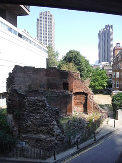
Ruined Tower of St. Elsyng Spital and St. Alphage Highwalk
SWC Short Walk 47 - The London Wall
Aug-20 • thomasgrabow on Flickr
swcwalks short47 walkicon 50273593253
![Large Piece of the London Wall by Bay 52 of London Wall Car Park SWC Short Walk 47 - The London Wall [Underground Car Park Extension]](https://live.staticflickr.com/65535/50274268146_95f3d1cb99_n.jpg)
Large Piece of the London Wall by Bay 52 of London Wall Car Park
SWC Short Walk 47 - The London Wall [Underground Car Park Extension]
Aug-20 • thomasgrabow on Flickr
swcwalks short47 walkicon 50274268146
Bastion 14 of the London Wall with the Museum of London and parts of the Barbican Estate
SWC Short Walk 47 - The London Wall
Aug-20 • thomasgrabow on Flickr
swcwalks short47 walkicon 50274430527
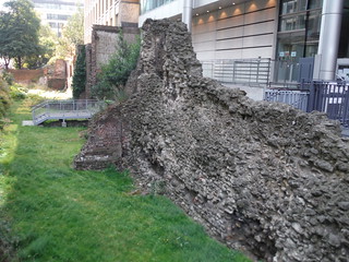
Very large piece of the London Wall, from Noble Street Viewing Walkway
SWC Short Walk 47 - The London Wall
Aug-20 • thomasgrabow on Flickr
swcwalks short47 walkicon 50274267686
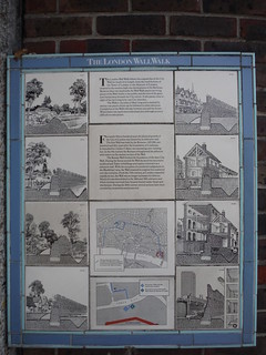
Panel 1 of The London Wall Walk, Tower Hill
SWC Short Walk 47 - The London Wall
Aug-20 • thomasgrabow on Flickr
swcwalks short47 50274271646
| Length |
4.5 km (2.8 mi). Cumulative ascent/descent: negligible. |
|---|---|
| Toughness |
1 out of 10 Time: 1 ½ hours walking time. |
| Transport |
Tower Hill Underground Station is a stop on the Circle and District lines between Monument and Aldgate/Aldgate East stations respectively and only a short distance from Tower Gateway DLR and Fenchurch Street Main Line stations as well as the Tower Millennium riverboat pier. Blackfriars Station is on the Thameslink line through Central London and also a starting point for limited commuter services to Kent run by Southeastern Railway. It is also a stop on the Circle and District Lines of the Underground and close to Blackfriars Millennium riverboat pier. Both stations as well as the whole route are within Zone 1. |
| Walk Notes |
This highly interesting walk follows as closely as possible the course of the London Wall as it would have run during Roman times around the settlement of Londinium, starting at the (medieval) fortress of the Tower of London and leading through the modern-day City of London past the sites of the former city gates to the westerly wall end at modern Blackfriars. It also passes the site of the much older first Roman Fort (built AD 120) at the north westerly corner of the city, whose walls were later incorporated into the Wall (built ca. AD 190-230). Street levels would have been up to 7 metres lower than today, so many remaining parts of the Wall are now hidden from view in the basements of buildings or under roads, but the route still passes a surprisingly large number of publicly accessible exposed sections of the Wall above ground (plus one section below ground on an optional extension). Wall parts as seen today have been much altered during the Middle Ages and some of the info panels or the walk directions point out these alterations. The route initially closely follows a signed London Wall Walk established by the Museum of London in 1984 for the section from the Tower to the Museum and passes the remaining info panels from that time plus several modern-day replacement panels. At the end of the 3rd century, following a series of raids by Saxon pirates, an additional riverside wall along the Thames was added, but no evidence of it survives today. Nevertheless, two options are described to make this a circular walk, either along the modern-day waterfront or along the line of the Roman Era waterfront, which ran further inland. |
| Walk Options |
Dropout points are aplenty along the route at tube stations or bus stops. An Extension leads to a large section of the Wall in the underground London Wall Car Park (320m each-way). The route can be made into a circular walk by following a choice of routes back to the Tower, both add 2.3 km to the route:
|
| Refreshments |
En route
Near the end of the circular route, back at Tower Hill
|
| Notes |
London Wall Walk The London Wall Walk was devised by the Museum of London in 1984 and over a length of 2.8 km it follows the original line of the City Wall for much of its length, from the Tower of London to the Museum of London. It passes many surviving pieces of the Wall visible to the public and the sites of the gates now buried deep beneath the City streets. The Walk was marked by twenty-one info panels, some of whom have disappeared though over the years due to building works – although some of the missing panels have been adequately replaced by similar panels in different design. The surviving original panels can be followed in either direction, as they are showing in some detail the routes to the previous and subsequent panels. The section west of the Museum of London is not covered by the London Wall Walk, as there are no surviving pieces of the Wall in the public sphere anyway. The Roman Fort/Roman Wall/London Wall The London Wall was the defensive wall first built by the Romans around Londinium, their strategically important port town on the River Thames, and subsequently extended and maintained until the 18th century. It is now also the name of a road running along part of the course of the old wall between Wormwood Street and the Rotunda junction where St. Martin's Le Grand meets Aldersgate Street. Until the later Middle Ages, the wall defined the boundaries of the City of London. Nowadays its line is still evident in the names of churches or churchyards: -within- or -without-. Although the exact reason for the wall's construction is unknown (occasional attacks by Picts, Scots and Saxons are prime suspects though), it appears to have been built between AD 190 and AD 230. This was around 80 years after the construction of the legionary fortress in AD 120, whose north and west walls were thickened and doubled in height to form part of the new city wall. The incorporation of the fort's walls gave the walled area its distinctive shape in the north western part of the city near modern-day Cripplegate. As well as providing defence, the construction of a stone wall represented the status of the city. The wall's gateways coincided with their alignment to the British network of Roman roads. The original four gates (plus one into the legionary fortress), clockwise from west to east were: Ludgate (for Westminster), Newgate (for Watling Street to Verulamium/St Albans as well as Calleva Atrebatum/Silchester and on to The West), Cripplegate (for the fortress), Bishopsgate (for Ermine Street to Eboracum/York and The North) and Aldgate (for The Great Road to Camulodunum/Colchester and The East). Aldersgate, between Newgate and Cripplegate, was added around AD 350. Moorgate, initially just a postern (i.e. pedestrian) gate, was enlarged later still: in 1415. When finished, the wall was 3.2 km long, enclosing an area of 135 hectares, and up to 3m wide and up to 6m high. In front of the eastern face of the wall was a ditch, which was up to 2m deep and 5m wide. The Wall was built of rubble (mostly Kentish ragstone brought by barge from quarries near Maidstone) bound in a hard mortar, and faced on either side by roughly squared ragstone blocks. At every fifth or sixth course the wall incorporates a horizontal band of red Roman tiles, intended to ensure the courses remained level over long stretches of masonry. This gives the wall its distinctive striped appearance. The wall was originally built without the external D-shaped bastions or turrets that can be seen in several places around the city: these were added in the 4th century AD, almost certainly as emplacements for catapults or stone-throwing engines. After several raids by Saxon pirates in the late 3rd century, construction of an additional riverside wall began in AD 275, and this was repaired around AD 390 (no evidence of this survives in the current streetscape though). The riverside wall had 13 water gates where goods were unloaded from ships. The Roman wall remained standing after the departure of the Roman army in AD 410, through a long period during which the city seems to have been largely abandoned. It was repaired in the late Anglo-Saxon period and survived to be an important feature of the city plan at the time of the Norman Conquest of 1066. Large parts of the wall were incorporated into the medieval defences of the city and additional fortifications were added (chiefly more bastions, the building of the Tower of London and a westerly extension to the Fleet River, enclosing Black Friars Priory, as well as extensions towards the changing Thames riverfront, following land reclamation). The wall continued to influence the development of the city street plan through the Middle Ages and beyond. By the mid-17th century buildings had been erected against sections of the wall on either side. In time it was obscured and, later, partly destroyed during the construction of new buildings and railway lines. River Walbrook The Walbrook is a subterranean river in the City of London that gave its name to the Walbrook ward and a minor street in its vicinity. It played a very important role in the Roman settlement of Londinium, and flowed between the two low hills in it: Ludgate Hill to the west, and Cornhill to the east. The brook flowed southwards through the walled city, bringing a supply of fresh water whilst carrying waste away to the Thames, at Dowgate near modern day Cannon Street Station. During Roman times it was also used for transport, with the limit of navigation some 200m from the Thames. It was there that the Romans built a port and temple to Mithras on the east bank of the stream, ca. AD 250 (https://www.londonmithraeum.com/temple-of-mithras/). The London Wall seems to have had unintended consequences though, impeding the flow of the river and creating the marshy conditions which characterised the open space at Moorfields. Nowadays, as is true for most other central London rivers, the waters of the Walbrook are diverted into the sewage system, so only a storm overflow drain remains to be seen entering the Thames. River Fleet The River Fleet is the largest of London's subterranean rivers. Its headwaters are two streams on Hampstead Heath either side of Parliament Hill, each of which was dammed into a series of ponds in the 18th century – the Hampstead and Highgate Ponds. At the southern edge of Hampstead Heath, the rivers continue underground as sewers and join in Camden Town. The waters flow 6 km from the ponds to the Thames. In Roman times, the Fleet formed the western boundary of Londinium, and in Anglo-Saxon times it served as a dock for shipping, navigable up to where Holborn Viaduct now stands. The river's modern name is thought to derive from the Anglo-Saxon flēot "creek/tidal inlet". It gives its name to Fleet Street, the eastern end of which is at the site of the former Fleet Bridge, now Ludgate Circus. The lower reaches of the river were known as the Holbourne (or Oldbourne), from which Holborn derived its name. Billingsgate Roman House and Baths Billingsgate Roman House and Baths is an archaeological site in Roman London. The best-preserved parts of the house are a bath with hypocausts. Its ruins were discovered in 1848 while the Coal Exchange was built and the remains were preserved in the cellar of the building. Further excavations were made in 1967 to 1970, when the Coal Exchange was replaced by a new building and Lower Thames Street was enlarged. The remains were incorporated into the cellar of the new building. The Roman house was erected in the late 2nd century along the then waterfront of the Thames and had a north and an east wing around a courtyard. There was most likely also a west wing but nothing of it survived. The rooms in the east wing had underfloor heating. The whole complex was in use until the early 5th century. |
| Profile | |
|---|---|
| Help Us! |
After the walk, please leave a comment, it really helps. Thanks! You can also upload photos to the SWC Group on Flickr (upload your photos) and videos to Youtube. This walk's tags are: |
| By Car |
Start EC3N 4DJ Map Directions Finish EC4V 4DD Map Directions |
| Amazon | |
| Help |
National Rail: 03457 48 49 50 • Traveline (bus times): 0871 200 22 33 (12p/min) • TFL (London) : 0343 222 1234 |
| Version |
Apr-24 Thomas G |
| Copyright | © Saturday Walkers Club. All Rights Reserved. No commercial use. No copying. No derivatives. Free with attribution for one time non-commercial use only. www.walkingclub.org.uk/site/license.shtml |

Walk Directions
Full directions for this walk are in a PDF file (link above) which you can print, or download on to a Kindle, tablet, or smartphone.
This is just the introduction. This walk's detailed directions are in a PDF available from wwww.walkingclub.org.uk