Regents Park and Primrose Hill walk
A royal park and citiscape viewpoint
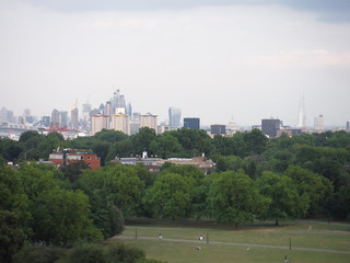
View from Primrose Hill: Shard to Canary Wharf
SWC Short Walk 6 - Regent's Park and Primrose Hill
Jul-18 • thomasgrabow on Flickr
swcwalks short6 banner 42750994174

Frieze Sculpture Park 2018: Sean Scully, ‘Shadow Stack’
SWC Short Walk 6 - Regent's Park and Primrose Hill
Jul-18 • thomasgrabow on Flickr
swcwalks short6 walkicon 29596586838
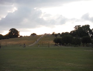
Primrose Hill
SWC Short Walk 6 - Regent's Park and Primrose Hill
Jul-18 • thomasgrabow on Flickr
swcwalks short6 walkicon 42750996204


| Start | Regents Park underground station. |
|---|---|
| Finish | Chalk Farm underground station. |
| Length |
5.9 km. |
| Time | 1 hour 30 minutes. |
| Travel | Regent's Park is on the Bakerloo line and Chalk Farm is on the Northern line and both are within Travelcard Zone 2. |
| Walk Notes |
Stroll through Regent's Park and along the Grand Union Canal, to then climb Primrose Hill for fine views over London. |
| Eat |
The Queen's , 49 Regents Park Road, NW1 8XD. T: 020 7586 0408. The Princess of Wales , 22 Chalcot Road, NW1 8LL. T: 020 7722 0354. The Engineer , 65 Gloucester Avenue, NW1 8JH. Gastro-pub food until 22:00. T: 020 7483 1890. The Pembroke Castle , 150 Gloucester Avenue, NW1 8JA. T: 020 7483 2927. |
| Profile | |
|---|---|
| Help Us! |
After the walk, please leave a comment, it really helps. Thanks! You can also upload photos to the SWC Group on Flickr (upload your photos) and videos to Youtube. This walk's tags are: |
| By Car |
Start NW1 5HA Map Directions Finish NW3 2BP Map Directions |
| Amazon | |
| Help |
National Rail: 03457 48 49 50 • Traveline (bus times): 0871 200 22 33 (12p/min) • TFL (London) : 0343 222 1234 |
| Version |
Apr-24 DAC |
| Copyright | © Saturday Walkers Club. All Rights Reserved. No commercial use. No copying. No derivatives. Free with attribution for one time non-commercial use only. www.walkingclub.org.uk/site/license.shtml |

Walk Directions
- Coming out of Regent's Park underground station, turn right (Great Portland St. Station exit) to go east along Marylebone Road for 80 metres, to then turn left (crossing Marylebone Road via pedestrian lights) along Park Square East. After 120 metres cross over Outer Circle (road) to enter the south east corner of Regents Park, and turn left along a tarmac path towards a fountain. In 80 metres pass by this fountain and then after a further 40 metres at a second fountain, turn right, along a tarmac path in a northerly direction.
- After 300 metres (having passed by two fountains along the way), you reach a fountain ahead, where you veer right to continue in the same direction along the main tarmac path. In 40 metres you cross over Chester Road via a zebra crossing to go along Broad Avenue, passing by a café on your left. In 80 metres fork left along a broad tarmac path. After 200 metres with a cream painted building (St. Johns Lodge) 80 metres off to your left, ignore a turn to the left, to continue ahead, 290°, with a metal fenced on your left, (with a wooded area and then a boating pond beyond).
- In 400 metres ignore a bridge over the pond to your left, to turn right towards the north west corner of the park. In 40 metres ignore a right fork, to veer left in a north westerly direction. After 550 metres cross over Outer Circle (road) and in a further 70 metres cross over Regents Canal.
- [!] Immediately over the canal bridge, turn right to go along Regents Canal, with the canal down to your right. (You may choose to go along an upper path from the towpath which eventually comes down to join the canal towpath.) After 550 metres (where the upper path comes down to join the towpath), you go under a second bridge, with the canal now going through London Zoo. In 200 metres (having passed by Snowdon Aviary on your left), you go under a bridge. After 220 metres you go under another bridge shortly followed by another bridge in a further 50 metres. Immediately past this bridge, fork left up a footpath (signposted London Zoo, Regents Park), to leave the canal, to come out onto Prince Albert Road with St. Marks Church opposite.
- Turn left along the road, passing by an entrance to London Zoo on your left after 25 metres. In a further 100 metres, cross over Prince Albert Road at the traffic lights to enter the south east corner of Primrose Hill Park.
- For a gentle ascent up the hill, turn left along a tarmac path, towards the west side of the park to then follow a route round to the right to the top of the hill.
- From the top of the hill, take the path heading easterly (with a line of trees on its left hand side) downhill. After 250 metres at the north east corner of the park, ignore a park exit to turn right along the edge of the park across grass, bordered by a metal railed fence (if wet, leave the park through the gate and turn right along the road pavement). After 160 metres turn left to exit the park to cross over Regent's Park Road via a zebra crossing, to go along Fitzroy Road. In 160 metres at a cross roads (with The Prince of Wales pub on the right hand corner), turn right along Chalcot Road. In 180 metres at a T-junction with Princess Road, turn left to reach The Engineer pub after 120 metres on the right side of the T-junction with Gloucester Avenue.
- Route to Camden Town station from The Engineer : Coming out of the Gloucester Avenue entrance of The Engineer, cross over the road and pavement to then turn right down an alleyway leading to the canal. In 40 metres turn left along the canal. After 130 metres pass by The Pirate Castle and in a further 120 metres follow the path up and over the canal to cross over to the opposite bank, passing by The Ice Wharf pub (a possible pub stop) on your right, to continue along the right bank of the canal. In 70 metres at a T-junction with Camden High Street, turn right to reach Camden Town station on your left after 160 metres (entrance at the back of teh building around the right).
- Route to Chalk Farm station from The Engineer : Coming out of the Gloucester Avenue entrance of The Engineer, turn left along Gloucester Avenue, NW. In 320 metres, just after where Gloucester Avenue has curved to the right, turn right over a car wide bridge (blocked to road traffic) to cross the railway. Immediately across this bridge, turn right down Regents Park Road. After 120 metres you reach a T-junction with Chalk Farm Road, with Chalk Farm underground station off to your left.