Rotherhithe walk
Parks and waterways on the Rotherhithe peninsula
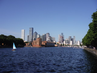
View across Greenland Dock to Canary Wharf
SWC Short Walk 54 - Rotherhithe (away from the river)
Jun-22 • thomasgrabow on Flickr
swcwalks short54 banner 52170559184

View from Stave Hill: Canary Wharf
SWC Short Walk 54 - Rotherhithe (away from the river)
Jun-22 • thomasgrabow on Flickr
swcwalks short54 walkicon 52170557759
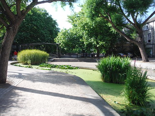
Albion Channel
SWC Short Walk 54 - Rotherhithe (away from the river)
Jun-22 • thomasgrabow on Flickr
swcwalks short54 walkicon 52170318533

Figurines on the Old School House, Rotherhithe Village
SWC Short Walk 54 - Rotherhithe (away from the river)
Jun-22 • thomasgrabow on Flickr
swcwalks short54 walkicon 52169293732

Southwark Park Bandstand
SWC Short Walk 54 - Rotherhithe (away from the river)
Jun-22 • thomasgrabow on Flickr
swcwalks short54 52170311986

Jabez West Drinking Fountain, Southwark Park
SWC Short Walk 54 - Rotherhithe (away from the river)
Jun-22 • thomasgrabow on Flickr
swcwalks short54 52169291892

The Caryatides of Rotherhithe Old Town Hall, Southwark Park
SWC Short Walk 54 - Rotherhithe (away from the river)
Jun-22 • thomasgrabow on Flickr
swcwalks short54 52170317293
| Length |
7.3 km/4.5 mi (up to) Ascent: negligible Time: 1 ¾ hours |
|---|---|
| Toughness | 1 out of 10 |
| Walk Notes |
This varied route explores parks and waterways on the Rotherhithe peninsula rarely seen by occasional visitors, who tend to follow the Thames Path. Start from Bermondsey tube near the boundary with Rotherhithe, following a meandering route through the well-kept Southwark Park, then cut across to Greenland Dock, one of the few remnants of the once ubiquitous ponds and water channels of the Surrey Commercial Docks, used mainly for timber and grain trading, before walking along the spine of the peninsula through the enchanting Russia Dock Woodland, an infilled dock with plenty of visible reminders of its past. A short loop through the Stave Hill Ecology Park leads up to one the finest low viewpoints in town: Stave Hill, a 9-metre artificial mound with surround views to the Olympic Park, Canary Wharf, the City of London, Westminster and most high points in South East London. You then skirt around Surrey Water and follow the well-maintained Albion Channel (more remains of the former docks and quays) to Canada Water, currently one of London’s largest regeneration sites, before a final loop through the historic Rotherhithe village and – for a short stretch – along the Thames River, passing some famous pubs and ending back in Bermondsey. Southwark Park closes at night, check page 2 for the exact times. Russia Dock Woodland is open 24 hours. |
| Walk Options |
Surrey Quays, Canada Water and Rotherhithe stations are passed en route, as are several bus stops, enabling later starts/earlier finishes. |
| Eat / Drink |
Southwark Park Pavilion Café, lakeside, Southwark Park; The Yellow House, Lower Road, Surrey Quays; The Moby Dick (Fuller’s), Greenland Dock; Leadbelly’s Bar & Kitchen, Deal Porter Square, Canada Water; The Brunel, Swan Road, Rotherhithe; The Mayflower (The Black Dog Pub Company), Rotherhithe Street, Rotherhithe Village; Simplicity Café & Restaurant, Tunnel Road, Rotherhithe Village; The Watchhouse Café, St. Marychurch Street, Rotherhithe Village; The Ship, St. Marychurch Street, Rotherhithe Village; The Angel (Sam Smith’s), Bermondsey Wall East, Rotherhithe; The Old Justice, Bermondsey Wall East, Bermondsey; The Gregorian (Antic Collective Pub Company), Jamaica Road, Bermondsey. |
| Travel |
Bermondsey and Canada Water Underground stations are served by the Jubilee Line. Canada Water lies at the junction with the former East London Line, now part of the Overground, which also stops at Surrey Quays and Rotherhithe. All those stations are passed en route and in Travelcard Zone 2. |
| Notes |
Bermondsey Station … is in the eastern part of Bermondsey and also serves the western part of Rotherhithe. It has been built as part of the Jubilee Line Extension between London Bridge and Canada Water stations and is notable for its extensive use of natural light, achieved by latticed concrete beams letting light penetrate to the platforms. Rotherhithe Rotherhithe lies on a peninsula in a bow of the Thames River on formerly marshy land unsuitable for farming, opposite Wapping, Shadwell and Limehouse on the north bank and Poplar and Millwall on the Isle of Dogs. The name derives from the Anglo-Saxon Hrȳðer-hȳð, meaning "landing-place for cattle". In the past Rotherhithe was also known as Redriff/Redriffe and it borders Bermondsey to the west and Deptford to the south east. Originally the most north easterly part of Surrey, it became part of the Metropolitan Borough of Bermondsey from 1900 to 1965. The Borough of Bermondsey was then amalgamated with Southwark and Camberwell Boroughs to become the modern-day London Borough of Southwark. Rotherhithe has a long history as a port, with many shipyards from Elizabethan times until the early 20th century and with working docks until the 1970s. All but a few of these have since been demolished, infilled and developed for housing. Famously, in 1620 The Mayflower sailed from Rotherhithe with its cargo of Pilgrims, and in the 19th century, the Brunels (father and son) built the Thames Tunnel, the first underwater tunnel in the world, linking Rotherhithe to Wapping (it is now part of the Overground railway). As a legacy of the former strong trade links to Scandinavia and the Baltic region, the area is still home to a thriving Scandinavian community and to Norwegian, Finnish and Swedish churches, which were originally established as seafarer’s missions. During WWII, Rotherhithe housed the Norwegian Government-in-Exile. Southwark Park Southwark Park is located in Rotherhithe, and is managed by the London Borough of Southwark. It was first opened in 1869 by the Metropolitan Board of Works as one of its first parks and covers 250,000 m2. Although now within the modern-day London Borough of Southwark, at the time of its opening Rotherhithe was part of Surrey, so it is thought that the park’s name was chosen to reflect the then Parliamentary constituency of Southwark. Facilities include: a bandstand (from 1884), originally sited in the Royal Horticultural Society grounds at South Kensington, an Old English Cottage-garden, a rose garden, a wildlife garden, a café, a boating lake and Southwark Park Galleries (split over two buildings). Sports facilities include an athletics track, a bowling green, football pitches, a cricket pitch and tennis courts. The park also has a children's playground on the site of a former lido. http://www.friendsofsouthwarkpark.co.uk/ Closing times: 17.00 Jan, 18.00 Feb, 18.30/20.00 Mar, 20.30 Apr, 21.00 May, 21.30 Jun & Jul, 21.00 Aug, 20.00 Sep, 19.00/17.00 Oct, 17.00 Nov, 16.30 Dec. Greenland Dock/Surrey Commercial Docks The Surrey Commercial Docks were a large group of docks in Rotherhithe, located on the south bank (the Surrey side) of the River Thames. The docks operated in one form or another from 1695 to 1969. Most were subsequently filled in and redeveloped for residential housing, and the area is now known as Surrey Quays, although the name Surrey Docks is retained for the electoral ward. The area had long been associated with maritime activities: in July 1620 the Mayflower sailed from Rotherhithe to New England, and a major Navy dockyard was located just down the river at Deptford. The oldest of London's riverside wet docks, Howland Dock (after the family who owned the land) was laid out between 1695 and 1699 to form the largest dock of its time, able to accommodate 120 ships. By the mid-18th Century, the dock had become a base for Arctic whalers and was renamed Greenland Dock. By the 19th century an influx of commercial traffic from Scandinavia and the Baltic (principally timber) and Canada (foodstuffs) led to Greenland Dock being greatly expanded and more docks being dug for the increasing number of vessels. Eventually, 85% of the peninsula (1.9 km2), was covered by a system of nine docks, six timber ponds and the Grand Surrey Canal. Several of the docks were named after the origins of their cargos, hence Canada Dock, Quebec Pond, Norway Dock, Russia Dock. The decline set in after massive bomb damage in WWII, and was then hastened by the containerisation of global trade. The surviving areas of open water are: Greenland Dock, Surrey Dock (now Surrey Water), South Dock (a marina), remnants of Canada Dock (now Canada Water) and Norway Dock (re-dug after infill). Russia Dock Woodland Russia Dock Woodland is a long narrow park of 140,000 m2, created by the infilling of Russia Dock, save for a thin 'stream' through the woodland. The dock was originally used for importing softwood timber from Norway, Russia and Sweden. Known as "deal wood", it was mostly used for newsprint and for manufacturing furniture. The woodland still contains surviving dock features including the retaining wall capstones, depth gauges, bollards, mooring chains and crane tracks. Stave Hill Ecology Park Stave Hill Ecology Park is a 21,000 m2 nature area located on the infilled site of the former Stave Dock in the centre of the former Surrey Commercial Docks. |
| Profile | |
|---|---|
| Help Us! |
After the walk, please leave a comment, it really helps. Thanks! You can also upload photos to the SWC Group on Flickr (upload your photos) and videos to Youtube. This walk's tags are: |
| By Car |
Start SE16 4RX Map Directions Finish Deal Porter Way, Surrey Quays, London, SE16 Map Directions |
| Amazon | |
| Help |
National Rail: 03457 48 49 50 • Traveline (bus times): 0871 200 22 33 (12p/min) • TFL (London) : 0343 222 1234 |
| Version |
Apr-24 Thomas G |
| Copyright | © Saturday Walkers Club. All Rights Reserved. No commercial use. No copying. No derivatives. Free with attribution for one time non-commercial use only. www.walkingclub.org.uk/site/license.shtml |


Walk Directions
Full directions for this walk are in a PDF file (link above) which you can print, or download on to a Kindle, tablet, or smartphone.
This is just the introduction. This walk's detailed directions are in a PDF available from wwww.walkingclub.org.uk