Severn Bridge Short Walk
Walk the Severn Bridge from England to Wales over the Severn Estuary
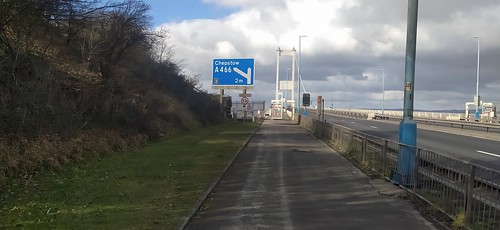

Severn Bridge - east side path, looking to Wales
Feb-23 • Andrew Murphy on Flickr
swcwalks short37 52712358705

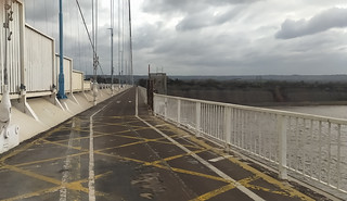
Severn bridge - looking back to England
Feb-23 • Andrew Murphy on Flickr
swcwalks short37 52711942266
| Start and Finish | Severn Bridge Services (M48 J1) in England or Thornwell (M48 J2) in Wales |
|---|---|
| Length | 5 miles / 8 km |
| Time | 2 hours |
| Walk Notes |
This is a walk from England to Wales, over the grade I listed (old, M48) Severn Bridge, an iconic suspsnsion bridge high over the Severn Estuary, with far reaching views throughout. The walk is unusual but spectacular, with a motorway on one side, and an amazing view on the other. Would be great to break up a long journey to/from South Wales. The 2.5 mile long River Severn suspension bridge is high (50 to 60m, depending upon the tide) over the Severn Estuary. It has walk/cycle path on the 'sea' side, and a footpath on the inland side. Walk out on one side of the bridge, back on the other. The walk is great on a sunny or partly cloudy day with 'big sky', but is very exposed. Don't do it on a rainy or windy day. If you fancy company, there is a Severn Bridge Parkrun every Saturday @ 9am which starts from the Welsh side (but it turns back in the middle, as its 5km, not 5 miles) The paths are occasionally closed for bridge maintainance, during a 'critical incident' or 'severe storm' (there is an 'open or closed' sign at the start). Check @2SevernBridges (Twitter) Note : The newer M4 bridge does not have footpaths. |
| Walk Options |
You could do a shorter out-and-back walk from the Severn Services (England side) which is the best bit. The Wales side has a 1 mile long viaduct at the start over the River Wye leading to the main bridge, but the England side is straight out over the Estuary to the highest part of the bridge. |
| Travel |
English side : Severn Services (M48 J1) in England, BS35 4BH, is closest to the path. 2 hours free parking (not enough time to do the entire walk), but perfect for a quick out-and-back. Keep left on the way in until a few spaces by a car barrier to an insurance company offices. Or try BS35 4BG (the other exit from the Motorway Junction, opposite the services road), and walk along the maintainence access road to the bridge. Thornwell (M48 J2) in Wales, NP16 5GH : free on street parking, but further from a motorway junction. It is now free for cars to cross the bridge - the toll has been abolished. Public transport: Train to Chepstow, then follow the start of the signed Wales Coast Path (WCP) for 2.5km to Thornwell. The WCP passes under the M48 at the start of the walk). |
| Eat/Drink |
England : Severn Bridge services, and a pub in Aust village Wales : Tesco Express and Thornwell Football Club Pavillion Cafe (evenings, all day Wed-Sun, NP16 5GH) has a terrace with a nice view |
| Notes |
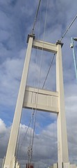
The first Severn Estuary crossing was the 1886 Severn rail tunnel on the Paddington - South Wales mainline. It was the world's longest underwater tunnel for over 100 years. The tunnel has a very corrosive atmosphere with diesel fumes and humidity - the track has to be replaced every 6 years. The tunnel suffers from water infiltration - nearby springs - large pumps have run continuously since it was opened to pump water out. From 1924, until the opening of the Severn Bridge, a car ferry operated across the river. In 1966, the Severn Bridge (this walk's bridge) opened, carring the 4 lane M4 Motorway, and 2 walk/cycle paths. As of Jan-20, it has the world's 43rd longest span (between the towers distance). The motorway has been renamed the M48. The 1996 Second Severn Crossing (now the Prince of Wales Bridge) carries the 6 lane M4 motorway was built to replace the original which was approaching full capacity, and needed weight limits due to corrosion. It does not have footpaths. Due to its design, it can stay open in windier weather than the original. It is downstream of the first bridge, and has a shorter route. When the new bridge opened, the M4 motorway was diverted over it. The motorway over the old bridge was renamed the M48. Its usually fairly quiet. The bridge consists of 4 structures, from west to east: (River) Wye Bridge, Beachley (peninsular) Viaduct, (River) Severn Bridge, Aust Viaduct The Severn Bridge Services isn't the original building on the cliff edge with a view, but a new inland building closer to the Junction without a view. The toll over both bridges was removed in 2018 The Severn Estuary has the second highest tidal range in the world - 14.5m / 48ft. |
| Profile | |
|---|---|
| Help Us! |
After the walk, please leave a comment, it really helps. Thanks! You can also upload photos to the SWC Group on Flickr (upload your photos) and videos to Youtube. This walk's tags are: |
| By Car |
Start Map Directions |
| Amazon | |
| Help |
National Rail: 03457 48 49 50 • Traveline (bus times): 0871 200 22 33 (12p/min) • TFL (London) : 0343 222 1234 |
| Version |
Feb-23 Andrew |
| Copyright | © Saturday Walkers Club. All Rights Reserved. No commercial use. No copying. No derivatives. Free with attribution for one time non-commercial use only. www.walkingclub.org.uk/site/license.shtml |


Walk Directions
Starting in England, at the suggested parking just past the Motorway Services.
- Walk on, past the offices, to the Severn viewpoint (no access to the bridge path). Return.
- Follow the signed walk/cycle to cross over the motorway to the 'sea' side, and follow the access walk/cycle path to the bridge. Continue to Wales.
- In Wales, follow the steps down, and walk through a tunnel under the motorway, very briefly joining the Wales Coast Path. Go left to access the bridge path, or turn right, north for Thornwell.
- Then back up onto the bridge, and walk back to England.
- Annoyingly, at the end of the bridge, you have to continue 500m inland, to a junction to cross back to the other side (i.e. the bridge over the Motorway only connects to the services, not to the 'inland side' path. You could scramble up the embankment, but it's pretty overgrown.
- Follow the start of the acces path, and cross back over the bridge to the services.