Stanmore Circular walk
Undulating route through various parks, commons and nature reserves in leafy North London, including the London Viewpoint
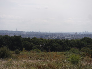
View from The London Viewpoint, Wood Farm, Stanmore: Shard, BT Tower and Nine Elms
SWC Short Walk 56 - Stanmore Circular
Jul-23 • thomasgrabow on Flickr
swcwalks short56 banner 53077623415

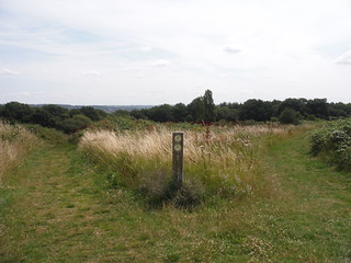
Stanmore Country Park
SWC Short Walk 56 - Stanmore Circular
Jul-23 • thomasgrabow on Flickr
swcwalks short56 walkicon 53077212681
Wood Farm, Stanmore
SWC Short Walk 56 - Stanmore Circular
Jul-23 • thomasgrabow on Flickr
swcwalks short56 walkicon 53076640202
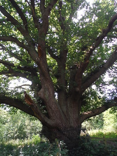
The Master Oak, Bentley Priory Nature Reserve
SWC Short Walk 56 - Stanmore Circular
Jul-23 • thomasgrabow on Flickr
swcwalks short56 walkicon 53076642782
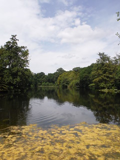
Summerhouse Lake, Bentley Priory Nature Reserve
SWC Short Walk 56 - Stanmore Circular
Jul-23 • thomasgrabow on Flickr
swcwalks short56 walkicon 53077714313
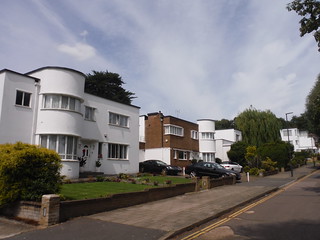
Kerry Avenue, Warren Estate, Stanmore
SWC Short Walk 56 - Stanmore Circular
Jul-23 • thomasgrabow on Flickr
swcwalks short56 53077407894
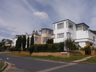
Kerry Avenue, Warren Estate, Stanmore
SWC Short Walk 56 - Stanmore Circular
Jul-23 • thomasgrabow on Flickr
swcwalks short56 53077407934
| Length |
8.7 km/5.4 mi Ascent/Descent: 154m Time: 2 ¼ hours |
|---|---|
| Transport |
Start & Finish: Stanmore Underground Stanmore station is the northern terminus of the Jubilee Line and in Travelcard Zone 5. The journey time from Baker Street is 28 minutes, but shorter if using the Metropolitan Line to Wembley Park. |
| Walk Notes |
This undulating route in a leafy part of North London almost completely eschews roads and housing to lead through three separate large Nature Reserves or Commons with a couple of smaller green areas in between, providing for a large variety in ecologies, including secondary and ancient woodlands, streams and ponds, coarse grassland, unimproved neutral grassland, acid grassland, heathland, scrubland, open glades and wetlands. Many areas are rich in wildflowers, butterflies and moths. You rise up through the fine Modernist Warren Estate and through the wooded Stanmore Country Park to Wood Farm Local Nature Reserve with the London Viewpoint and its panoramic views across London from Alexandra Palace to Heathrow via The City, Wembley and Harrow and out to the North Downs. Descend through grassland and reascend through Cloisters Wood to reach the ridge of Stanmore Hill at Little Common. You pass Stanmore Common’s Brewer’s Ponds and in the decidedly wilder Common proper have a choice of routes through it. Lastly, the descent through Bentley Priory NR, location of RAF Fighter Command during WWII, enchants with quiet grasslands and varied woods, as well as more vistas to parts of London. Also passed are a large artificial pond with a very old oak tree and a private deer park (on a shortcut). |
| Walk Options |
Bus Line 142 travels along The Common (the A4140) and its Stanmore Priory Drive stop is passed 4.3 km into the walk. This connects to Stanmore and Edgware Tube Stations or to Watford Junction. Extensions are described in Stanmore Country Park (add 350m), Stanmore Common (add 1.0 km) and in Bentley Priory NR (add 400m). The longest version of the route has 10.5 km. Shortcuts are possible by cutting out the loop through Stanmore Common and by taking a more direct route through Bentley Priory Park, along the Deer Park on tarmac rather than through the grasslands and woods and past the ponds on partly mud-prone paths, or by taking a clockwise route around the pond. An Alternative Ending leads along the main road through Stanmore (the A410), past more tea options. Bus Lines travelling along the A410 through Stanmore to the Station cut up to 1.1 km on this option. |
| Eat |
Main Walk: Bistro 101 and Everest Abercorn and Agra Indian Restaurants. Town Option: Spice Rack Lounge; Costa Coffee; The Oak Caffe (to 16.00 daily); Sahara Lounge; Barracuda restaurant; Caffé Nero (to 17.30 daily); Pizza Express; Cartons of Stanmore boulangerie. There are no pubs in Stanmore. |
| Notes |
Stanmore and Stanmore Station Stanmore is most likely named after a couple of stony ponds or "Stane Meres". The likely candidates – now referred to as Spring Ponds – are passed on the route at the highest point of the walk. The ancient Brittonic grassy trackway from Dover to Wroxeter (and on to the land of the Picts), paved by the Romans and named Watling Street by The Saxons, runs east of Stanmore along what is now the boundary to Edgware. Stanmore Station was opened in December 1932 by the Metropolitan Railway (now the Metropolitan Line). The station building and others on the branch were designed in the suburban style used on the company's other post-WWI stations such as those on the Watford branch. The branch line and station presented competition for the London, Midland and Scottish Railway’s train service from Stanmore Village Station approximately 1 km away. The LMS trains connected to the West Coast Mainline at Harrow & Wealdstone (then ‘Harrow’), for London-bound services. This branch line ceased operations in 1952. The Stanmore to Baker Street Metropolitan Line suffered from severe congestion on the Finchley Road to Baker Street section, so that in the late 1930s new tunnels and stations were built and the new line was run as a branch of the Bakerloo Line. In the 1970s, similar congestion problems for the Bakerloo line caused by two branches converging at Baker Street led to the creation of the Jubilee line, initially by connecting the Stanmore branch to new tunnels bored between Baker Street and Charing Cross via Green Park, later still extended from Green Park via Waterloo, the Southbank and the Docklands to Stratford. Stanmore Country Park and Wood Farm In 1813, Sir Robert Smirke purchased Warren House (now Springbok House) and the surrounding estate. In 1922, this was acquired by Sir John Fitzgerald, who introduced Kerry Black cows from County Kerry, his native lands. He sold off some of the land near Stanmore Station to be developed into the Warren House Estate, built in Modernist design, while naming the roads there after places in Kerry. In 1940, Fitzgerald sold the rest of the land to Middlesex County Council as Green Belt Land, the future Stanmore Country Park. The underlying soil consists mostly of London Clay in the lower parts, so several paths are mud-prone there, but of Claygate Beds and Stanmore Gravel Beds in other parts. This means that very different ecologies can be seen, i.e.: open grassland (some of which acid grassland), streams and ponds, young secondary woodland but also a fragment of ancient, i.e.: bluebell wood and some ancient oaks (remnants of former field boundary hedges). The park is rich in butterflies and moths. Wood Farm lies north of Stanmore CP and is continuous with it. It was a working farm until around the end of the 20th century and was only opened to the public in 2015. The farm buildings have disappeared bar the Old Dairy which now serves as a visitor centre. Notable is the London Viewpoint with some panoramic views and a toposcope: on a clear day you can see from Alexandra Palace in the east to Heathrow in the southwest, and over Central London to the North Downs around Box Hill 44 kilometres away. Stanmore Common The 49 hectare-sized Stanmore Common is an open space in Harrow with a great sense of wildness, made accessible through a network of winding paths. The subsoil ranges from London Clay in the lowest sections through Claygate Beds to the quickly draining Stanmore Gravels. It contains good examples of acid grassland and heath, mature woodland and wetlands. Some of the paths can be muddy. The first recorded mention of Stanmore Common dates back to AD793, when land in the area was granted to St Alban’s Abbey by the King of Mercia. The abbey held onto the land until the Norman Conquest when it was seized by the Crown Estate. Before the Enclosure Act, Stanmore Common was largely heathland, which was used by people for collecting fuel and rough pasture. The area had poor soil, which made it unsuitable for agricultural improvement, and so it remained largely untouched. As livestock numbers dwindled in the early 20th century, the heathland began to convert to secondary woodland. It is maintained by volunteers. The Common contains a Bronze Age tumulus and a Pillow Mound (a medieval rabbit warren). Bentley Priory House, Park and Nature Reserve Bentley Priory was an Augustinian priory of Canons in the Middle Ages, but it ceased to exist before the Dissolution of the Monasteries in the 1530s. In 1775 Sir John Soane designed a new house which stood north of the original priory, called Bentley Priory House. The name Bentley is derived from the Anglo-Saxon ‘leah’ for clearing, combined with ‘Beonet’, a place covered in coarse grass. This remains a feature of much of the site today, and includes traditional grassland which has never been treated with fertilisers, and hence is rich in wild flowers. Bentley Priory has a number of woods, including Heriot’s Wood. Its dominant tree is hornbeam, and there are wild service trees as well, both species characteristic of ancient woodlands. It probably dates back to the end of the last Ice Age 11,500 years ago. The Stanburn (further downstream called Edgware Brook), a tributary of the Silk Stream and thence the Brent, was dammed to form Summerhouse Lake. The grounds and house were separated when the house became RAF Bentley Priory, the headquarters of Fighter Command during WWII. They are now maintained as the 66 hectares Bentley Priory Nature Reserve, a SSSI and Local Nature Reserve. It contains an unusual combination of habitats for Greater London, namely ancient woodland, unimproved neutral grassland, scrub, wetland and streams (plus a private deer park: the deer were originally introduced in the 18th century). |
| Profile | |
|---|---|
| Help Us! |
After the walk, please leave a comment, it really helps. Thanks! You can also upload photos to the SWC Group on Flickr (upload your photos) and videos to Youtube. This walk's tags are: |
| By Car |
Start HA7 4PD Map Directions |
| Amazon | |
| Help |
National Rail: 03457 48 49 50 • Traveline (bus times): 0871 200 22 33 (12p/min) • TFL (London) : 0343 222 1234 |
| Version |
Apr-24 Thomas G |
| Copyright | © Saturday Walkers Club. All Rights Reserved. No commercial use. No copying. No derivatives. Free with attribution for one time non-commercial use only. www.walkingclub.org.uk/site/license.shtml |

Walk Directions
Full directions for this walk are in a PDF file (link above) which you can print, or download on to a Kindle, tablet, or smartphone.
This is just the introduction. This walk's detailed directions are in a PDF available from wwww.walkingclub.org.uk